(India, Punjab, Sikh Empire.) a collection of 21 titles, including Syad Muhammad Latif, Khan Bahadur: 'Agra Historical & Descriptive, with an Account of Akbar and His Court and of the Modern City of Agra.', Calcutta, Calcutta Central Press Company Ltd, 1896, 1st edition, large folding map frontis + 41 (of 47) b/w illustrations, 308pp, original cloth gilt, 'The Great Temples of India, Ceylon, and Burma', London, Madras & colombo, The Christian Literature Society for India, 1904, 96pp, full page and in text b/w engraved ills. throughout, orig. cloth backed printed card wraps (worn), K.M. Panikkar: 'The Indian Princes in Council : a record of the chancellorship of His Highness, the Maharaja of Patiala, 1926-1931 and 1933-1936', London, Milford, 1936, 1st edition, signed & inscribed by the author on FFEP, original cloth gilt, Kirpal Singh: "Akal Sahai" A Catalogue of Punjabi and Urdu Manuscripts', Amritsar, Sikh History Research Department Khalsa College, 1963, 251pp + [1]pp advert at end, orig. cloth, Sir Gokul chand Narang: 'Transformation of Sikhism', Lahore, New Book Society, 1945, 2nd edition revised and enlarged, portrait frontis + 9 full page b/w ills., 400pp + [8]pp adverts at end, lacks FFEP, orig. cloth, Rev. henry F.W. Lester: 'Indian Village Pictures', L, London Missionary Society, 1910, frontis + 75 b/w illustrations (many from photographs) as called for, orig. pictorial cloth gilt, K.M. Sarkar: 'Punjab Government Record Office Publications. Monograph No. 1 - The Grand Trunk Road in the Punjab', [Lahore] : Punjab Government Record Office, [1927?], [12],49,[3]pp, 4 maps as called for, orig. quarter cloth, 'Struggle for Independence 1857-1947 A Pictorial Record', Karachi, Pakistan Publications, March 1958, 49pp, 100+ b/w ills. from photographs, orig. cloth gilt, Mohamed Akbar Khan Haidari: "The Munshi" A Standard Hindustani Grammar', Delhi : Haidari's Oriental Book Depot, 1921, 4th edition, original cloth, Charles Bruce: 'John Lawrence "Saviour of India" The Story of His Life', Edinburgh, Nimmo, 1893, port. frontis + 3 b/w plates, original decorative cloth gilt, all edges gilt, Loehlin: 'The Sikhs and Their Scriptures', Lucknow Publishing House, 1958, b/w ills., maps etc., original cloth backed boards, Ved Mehta: 'Daddyji', L, Secker & Warburg, 1972, 1st edition, later copy of the armorial bookplate of Lieutenant-Colonel David Waters Sutherland, married Princess Bamba 1915, mounted on FFEP, orig. cloth, dust wrapper, plus 9 others (21)


![(Classics, Ancient Greece, Rome.) A collection of 29 volumes, including Xenophon; [William Smith]: 'Xenophon's History of the](https://cdn.globalauctionplatform.com/b3c2c738-19d0-4d60-8532-b0c100bdc003/bcd0b26c-7ffa-4b90-ba44-b0c101090935/468x382.jpg)


![(London.) David Hughson [i.e. David Pugh]: 'London; being an accurate history and description of the British metropolis and i](https://cdn.globalauctionplatform.com/b3c2c738-19d0-4d60-8532-b0c100bdc003/c587a682-d7ba-42e3-8d38-b0c101097df9/468x382.jpg)


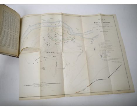
![[John Stacy]: 'A Topographical and Historical Account of the City and County of Norwich', London, Longman, 1819, 1st edition,](https://cdn.globalauctionplatform.com/b3c2c738-19d0-4d60-8532-b0c100bdc003/73751380-73ec-413b-b016-b0c10109934e/468x382.jpg)