We found 109182 price guide item(s) matching your search
There are 109182 lots that match your search criteria. Subscribe now to get instant access to the full price guide service.
Click here to subscribe- List
- Grid
-
109182 item(s)/page


Lot 268
CAPTAIN COOK'S VOYAGES ROUND THE WORLD in four volumes printed by M Brown at The Bible, in the Flesh Market, Newcastle Upon Tyne, 1790 including `Captain Furneaux's Journal of his Proceedings During the Separation of the Ships`, the title page with portrait of Captain James Cook, original map incomplete, with reproduction map and two reproduction plates, volume two with one reproduction plate, volume three with two reproduction plates, bound in tan leather with marbled ends in slip case (4) Condition Report: Available upon request
![Saxton (Christopher) Westmorlandiae Comitatus [Cumbria], engraved map by William Kip with early hand colour for Camden's Brit](https://cdn.globalauctionplatform.com/7ab3a4f9-004c-4553-bdfa-aa8900ba1876/c8036b79-7f88-4220-ab5d-aac800d992cd/468x382.jpg)
Lot 1125
Saxton (Christopher) Westmorlandiae Comitatus [Cumbria], engraved map by William Kip with early hand colour for Camden's Britannia [1637], framed and glazed [with] Wainwright (A.) Wharton Hall, [1975], original printing plate for 'Westmorland Heritage', displayed alongside a printed impression on paper, the two mounted in one frame (2)
Lot 882
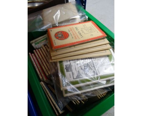
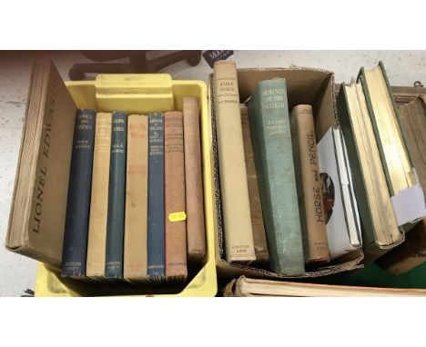
A collection of volumes on the subject of hunting, including LIONEL EDWARDS "Sketches in Stable and Kennel", published 1933, "Bridle Wise", "Songs and Verses", illustrated by Lionel Edwards, "Scattered Scarlet", "Hunting Songs", "Galloping Shoes" and "A Handful of Leather", all illustrated by Lionel Edwards, together with a box of books including K F BARKER "Just Dogs", sketches in pen and pencil, published Country Life 1933, tooled paper board bound, G D ARMOUR "Sport and There's the Humour of it", published Hutchinson & Co. London, SABRETACHE "Stand to your Horses", published Ocean Publishing Company 1932, SIR JOHN BUCHANAN JARDINE "Hounds of the world", published Methuen & Co.1937, JOHN BOARD "Horse and Pencil", published Christopher Johnson London 1950, JOHN DORMAN "It Could Have Been a Hound - Hunting with Ronnie Wallace" and an Old Berkshire Hunt map (folding)


Lot 520
A collection of vintage hunt maps to include map of the Duke of Beaufort's Hunt country, Swiss & Co's No 5 hunting map Gloucestershire, Monmouthshire & Wiltshire District, Verderer's map of the Beaufort Hunt, together with two large framed and glazed maps, various meet passes and a set of Dumfriesshire Fox Hounds hunt buttons, together with two large framed Swiss and co hunting maps


Lot 301
A collection of predominantly Third Reich era ephemera including a book entitled 'Sieg Über Frankreich, Wehrpas' and related documentation including part of a map featuring Minsk with hand written notes and annotations, an English language linen double sided map of Norther Egypt stamped 'Restricted', further booklets and maps, one titled 'Strassenzustands-karte von Deutschland', a book entitled 'Stolz und Trauer' by R.B. Binding, a small group of postcards promoting the Aryan race, etc.Additional InformationPostage of this lot would be £17 + VAT within the UK.


Lot 1142
A large 19th century map, 'Stafford-shire', with some later colouring, inscribed to lower border 'James Wyld, Geographer to The Queen, 11 & 12 Charing Cross, London.' and titled to lower wooden roller, approx 180 x 145cm including border.Additional InformationDirty, especially to lower section, fading of colours, staining, surface losses and tears in numerous places, particularly the right hand side but with further small tears in various places, surface scuffs, marks, heavy creasing and wear and tear, particularly to corners and edges, again will need attention, please view illustrations and request additional if necessary, sold as seen.
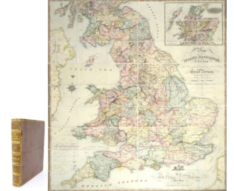
Lot 1144
J WALKER OF WAKEFIELD; 'Map of the Inland Navigation, Canals and Rail Roads with the Situations of the Various Mineral Productions Throughout Great Britain, from Actual Surveys Projected on the Basis of the Trigonometrical Survey Made by Order of the Honourable Board of Ordnance [...] Published by Richard Nichols, Bookseller, Wakefield [...] January 1st 1830 [...] to the King's Most Excellent Majesty this Map (With His Gracious Permission) is most Respectfully Dedicated by His Majesty's Most Obedient and Devoted Subjects, Nichols, Priestley and Walker', large coloured linen backed folding map, approx 190 x 156cm, housed in apparently original calf bound book form case with gilt tooled title to spine 'Map of Inland Navigation and Rail Roads'.Additional InformationOuter case worn, map with some discolouration, some surface marks, scuffs, small areas of loss, some spotting, please refer to illustrations and request additional if necessary.

Lot 1023
STANLEY, HENRY M; 'In Darkest Africa or the Quest Rescue and Retreat of Emin Governor of Equatoria', two volumes with illustrations and maps, Sampson Low Marston, Searle and Rivington, London 1890, in illustrated red cloth boards, also two volumes of William Shakespeare featuring illustrations, Charles Knight, one with publication detail of sixth edition, H.G. Bohn, London 1854 (4). Additional InformationVolume one of Darkest Africa apparently missing map, maps to second volume seemingly present, both worn condition, some tears to maps, pages, illustrations, etc. Please view illustrations and request additional if necessary, wear and tear to the boards of all volumes, please refer to photographs and request additional if necessary, we cannot guarantee presence of all illustrations, maps, inserts, etc.

Lot 1018
TOLKIEN, J.R.R; 'The Lord of the Rings' trilogy, comprising 'The Fellowship of the Ring', fourth impression November 1955, 'The Two Towers', second impression 1955, and 'The Return of the King', second impression November 1955, George Allen & Unwin Ltd, London (3).Additional InformationFellowship jacket only one present and is damaged with loss to spine, tears, creasing, discolouration and staining throughout, Christmas gift inscription to Fellowship, other two named to inside front page, all with maps to back, Return of the King map with a red residue and staining, some foxing and yellowing to pages particularly to Return of the King. The bindings are stretched, discoloured and scuffed at the edges. Some rippling to pages, the top of the pages is very dirty, heavy wear throughout.
![THOMAS HARGREAVES; 'To The Most Noble George Granville, Marquess of Stafford [...] This Map of the Staffordshire Potteries, &](https://cdn.globalauctionplatform.com/8fd1f7ac-92ba-46b2-9ac9-aac700970451/23910a01-7104-4ff6-bba6-aacb0104974a/468x382.jpg)
Lot 1147
THOMAS HARGREAVES; 'To The Most Noble George Granville, Marquess of Stafford [...] This Map of the Staffordshire Potteries, & Newcastle, Including their Vicinities Shewing the Limits of the Boroughs, Parishes, Townships, & see Engraved from a Minute Trigonometrical Survey [...] Thomas Hargreaves Land Surveyor and Engineer, Burslem 1st May 1832 [...] Engraved by James Wyld Geographer to His Majesty', with scale, reference and explanation tables, some later shading, approx 149 x 115cm, with wooden 'pediment' stencilled 'Hargreaves' Staffordshire Map of the Potteries.'Additional InformationMap heavily discoloured, appears to have been laminated or some similar process as it has a glossy finish, tear to outside border upper left with further fraying, scuffs, wear throughout, particularly to corners and edges, some surface losses, tears to lower centre section wooden 'pediment' also heavily worn with large gouge to centre, further losses, scuffs and scrapes, fading to colours and stencilling, in general map will need attention, please judge from illustrations and request additional if necessary.


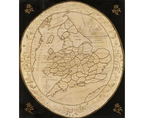
Lot 719
A REGENCY EMBROIDERED OVAL SILK MAP SAMPLER OF ENGLAND AND WALES M F EYRE 1816 worked in coloured silks with the figure of Britannia upper right, compass rose and parts of Scotland, Ireland and France framed by trailing foliage, 50 x 44cm, verre eglomise mount and beaded giltwood frame++Long undisturbed in the frame, the sampler in good condition with some creases and slight fading/light staining
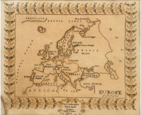
Lot 718
A VICTORIAN LINEN MAP SAMPLER OF EUROPE MARY SHAKESPEARE BRITISH SCHOOL BANBURY AGED 13 YEARS, 1855 50 x 60cm, stained wood frame++Generally faded to green, pale brown and black, the support browned and requires cleaning/conservation. No pulled threads, moth holes observed or darned repairs. Glass cracked, lower left corner


Lot 1426
WRIGHT (Paul) The New and Complete Life of our blessed Lord and Saviour Jesus Christ, London, printed for Alex. Hogg, n.d., engraved map and plates, original full calf, with a morocco label pasted inside 'Henry Jones 1779', The Holy bible Oxford: 1774, printed by T Wright and W Gill, original gilt red morocco, SOLOMON (S) A Guide to Health, 57th edition, Henry's Bible, 2 volumes, full leather and two other theological volumes (7).


-
109182 item(s)/page