We found 109182 price guide item(s) matching your search

Refine your search

Year

Filter by Price Range
  • List
  • Grid
  • 109182 item(s)
    /page

Lot 100

1. Wild Sports of Southern Africa, C. Struik, 1963. 8vo. Original harcover binding with dust jacket. xvi + 359pp. Facsimilie reprint of the 1852 edition, with 26 plates in colour, and a map.2. Portraits of the Game and Wild Animals of South Africa, Sable Publishers, 1986. Fo. Original harcover binding with dust jacket. vi + 175pp. Facsimilie reprint of 1840 edition.Wild Sports: Some rubbing and edgewear to dust jacket. Previous owner's name stamp to front pastedown. Some offsetting to front and rear free endpapers and pastedowns. A well bound copy, with clean plates and text.Portraits of the Game: Slight rubbing to dust jacket, and small indentations to rear of dust jacket. A well bound copy, internally clean and clear.

Lot 283

A RARE JAPANESE WOODBLOCK PRINT MAP OF THE WORLD BY HARAME SADAKIYO (ACT. 18TH CENTURY) EDO PERIOD, DATED 1720 Entitled Yochi zu or Yochi no zu (Picture of the World), depicting Europe, Asia and Africa on the left-hand side and the Americas to the right, with hand-coloured details later added in watercolour, together with a modern protective cover, 73.5cm x 147cm. (2) This map is based on an original design by Matteo Ricci (1552-1610), a famous Jesuit and polymath who was the first Westerner to translate the works of Confucius and to be admitted into the Forbidden City.

Lot 72

ÆŸ Pierre Albert de Launay, Remarques sommaires faites sur la maison d'Aerssen, in French, Latin and Dutch, a de luxe manuscript produced for Cornelis van Aerssen van Sommelsdijck, the first governor of Surinam, on paper [Northern Netherlands (North Brabant), dated 26 August 1684, and probably also 1688 and immediately after]57 leaves (plus 2 endleaves at front and 4 at back), complete, single column of 25 lines in a professional hand (some sections italic), titles in simple capitals, major initials in gold with gold foliage on blue grounds, frontispiece with large architectural inscription within female figures who hold the rod of Asclepius and the scales of justice, and cornucopia, arms of van Aerssen at head (with three helms and an ornamental collar) and another somewhat oxidised crowned coat-of-arms at foot (most probably those of St. André Montbrun, over which the family from Cornelis van Aerssen van Sommelsdijck onwards held a marquisate), one large two-page map in pen and colour wash, eight pages of coats-of-arms in colour, nine fine drawings of seals and a tomb in pen and colour wash, one double-page opening of coloured and illuminated arms arranged in genealogical tree, seal covered with paper on last page, a few loose leaves neatly rejoined to volume, a few spots and stains, but overall in excellent condition and on heavy paper, 436 by 282mm.; bound in contemporary green patterned silk over pasteboards, gilt edges (some wear to edges, and old repair to binding), prints of Cornelis van Aerssen (1545-1627), and his father Francois van Aerssen (1572-1641), both by "A. Schouman", loosely inserted in volume (but note these members of this family not associated with content of this book), along with a Dutch newspaper article (Algemeen Handelsblad, 3 August 1963) on Cornelius van Aerssen van Sommelsdijck (1637-88) A fine seventeenth-century manuscript principally produced for an important member of the Dutch nobility, who served as first governor of Surinam in the Dutch Guianas; in outstanding condition and still in its contemporary green silk covered binding Provenance: 1. Produced on commission for Pierre Albert de Launay (d. 1694), the Brabant Herald of Arms, for presentation to Cornelis van Aerssen van Sommelsdijck (1637-88): details recorded in inscription in cartouche on frontispiece, and with the completion date, de Launay's official seal on p. 96 and signatures at end of some sections. Cornelis van Aerssen van Sommelsdijck, lord of Sommelsdijk, Bommel, de Plaat and Spijk (in Zuid-Holland and Gelderland), was a prominent member of one of the wealthiest families of the 'Golden Age' of Netherlandish history. He was fundamental in the founding of the Surinam Society (a private trade company), and was elected by the West-India Company and the city of Amsterdam as the first governor of the colony of Surinam (founded 1667, gaining independence in 1975) in the Dutch Guianas. He left Europe in 1683 for Paramaribo. He is remembered as an authoritarian but efficient governor, and was killed by a band of mutinous Dutch soldiers in 1688, during an argument over alleged poor food and wages. As this volume specifically addresses him at the opening of the text as "Corneille D'Aerssen ... Seigneur en partie de Surinam, Gouverneur & Capitaine General de toute de Colonie" and its closing address is dated 1684, it may have been commissioned as a gift to honour his appointment as governor. However, the arms at the head of the frontispiece are those of his son, François (1669-1740), and the armorial genealogy on pp. 75-76 also terminates in the arms of this figure. The research for the volume may have taken some years, and it was perhaps not complete or bound when Cornelius was murdered, and it was finished for Cornelius' son. François had accompanied his father to Surinam, returning briefly to Europe in 1687, before travelling back to settle his father's affairs there. He then took up a post as director of the Society of Surinam.2. Still in the library of the Baron van Aerssen in 1838, when on 15 December that year it was shown to a meeting of the Belgian royal historical commission (see Compte-Rendu des séances de la Commission Royale d'histoire, VII, 1844, pp. 299-300).3. Janna Carla van der Veen-Hondius (1929-2001) of Duinbeek house in Oostkapelle, Zeeland: her printed armorial bookplate affixed to front endleaf.4. Sold in Christie's, 15 July 2015, lot 35 (but there misidentified as produced for the wrong Cornelis van Aerssen) for £5625. Text:This gargantuan codex is a triumph of seventeenth-century manuscript production. It celebrates the descent of the van Aerssen family to Cornelis van Aerssen van Sommelsdijck and his son François, collecting together relevant accounts and documents from a wide variety of sources. After an address by de Launay, the volume includes "Remarques sommaires sur la maison d'Aerssen" (p. 1); a genealogical table showing the links of the family to the house of Moers/Meurs and their dynastic founder Wallerand de Limbourgh (p. 5), followed by a tract on the same (p. 15); a hand drawn and coloured map of the Duchy of Guelders showing the holdings of the family (pp. 22-23), after the work of Nicolaes van Geelkercken, and probably copied from Joannes Janssonius (1639); extracts from an account of the nobility of Guelders in Henricus Aquilius' printed Compendio Chronici Geldrici (Cologne, 1566; here p. 25); followed by charters apparently copied from originals in the archives of the towns of Venlo and Nijmegen and the Cistercian abbey at Kamp/Campen, with skilfully drawn and hand-coloured depictions of their seals, parts of an armorial from the time of "Comte Reinault de Gueldres" dated 1330, with over 140 coats-of-arms in colour, and extracts from a martyrology of Kamp Abbey, and a drawing of the late fifteenth-century tomb of Theodore d'Aerssen and Marguerite de Carpen from the church in that monastery; an armorial tree of descent of the van Aerssen family down to François (1669-1740), the reigning head of the family in the 1680s (pp. 75-76); followed by further documents and a final address by de Launay (p. 93), dated at its end. 

Lot 122

MAP OF TURKEY IN EUROPE APP.SIZE: 37cm x 25cm (60cm x 42cm)

Lot 71

JOHN SPEDE MAP WOODEN GLASS TRAY

Lot 106

JOHN SPEDE HAND COLOURED MAP OF ESSEX

Lot 72

USAF 1966 DOUBLE SIDED SILK MILITARY MAP OF CHINA PART ONC H-10 & H-11

Lot 124

MAP OF ALEXANDER THE GREAT EMPIRE APP.SIZE: 40cm x 28cm (47cm x 32cm)

Lot 10

17th century, A hand coloured map of the East of England, 5" x 6.5". unframed.

Lot 396

A. HENRY SAVAGE LANDOR 1865-1924 TWO VOLUMES OF 'ACROSS WILDEST AFRICA', 'an account of the country and people of Eastern, Central and Western Africa as seen during a twelve month' journey from Djibuti to Cape Verde', illustrated by 160 half-tone reproductions of photographs and a map of the route, published by Hurst and Blackett Ltd. 1907, repaired paper-ends, bound with blue cloth with gilt lettering (some damage to spine).

Lot 397

ELEPHANT HUNTING IN EAST EQUATORIAL AFRICA' BY ARTHUR H. NEUMANN, copy no. 247 of 575, facsimile re-print by Rowland Ward, with slip sheet authenticated by Timothy Best, zebra print end papers with folded 'Map of a Portion of East Equatorial Africa Illustrating Journeys of A.H. Neumann during 1894-95&96', 455 page, bound with maroon red cloth and matching slipcase.

Lot 39

MAP OF NORFOLK AND BOTANICAL FLORAL PRINT

Lot 532

A MAP OF THE COUNTY OF CHESTER by Robert Morden, 35.5cm x 42cm together with a George III sampler my Mary Bromfield aged 13 years dated 1815 with motto and floral border, 30.5cm x 34.5cm; a map of Derbyshire; needlework map of Derbyshire and a needlework floral wreath (5) Condition: the Morden map not stuck down, with some slight foxing; the Bromfield sampler with some brown stains and marks, much later frame; the Derbyshire paper map with areas of foxing and staining; the Derbyshire needlework map with some slight stains, the needlework in moderate condition

Lot 1774

A box containing a collection of black and white photographs in several albums, a further album containing pictures of submarines, a famed map, of Winterbourne, etc (1)

Lot 402

An oak framed map depicting South Wales

Lot 209

A gilt framed map entitled "Commencement of the Roads to Glasgow and Edinburgh, as Far as Stamford with Roads to Uppingham and Market Deeping"

Lot 144

A large quantity of various pictures, prints and a map of Yorkshire

Lot 2476

An Omega Speedmaster 'Apollo-Soyuz' ref 145.022 stainless steel chronograph wristwatch with bracelet, circa 1976, caliber 861 seventeen jewel movement numbered 39181340, the screw down caseback with Apollo-Soyuz emblem with a stainless steel Omega bracelet, the ends numbered 633 and folding clasp numbered 1168, case diameter 40mm, the pushers measure 5.5mm diameter, with an associated red Omega box.Footnote:Amidst the Cold War era, on the 15th of July 1975, the American and Soviet space teams joined forces and embarked on the historical Apollo-Soyuz Test Project (ASTP).On July 17th, the ambitious mission resulted in a successful docking of the American Apollo and Soviet Soyuz spacecrafts.This international achievement was then commemorated the following year by Omega who issued a limited series of 500 special Speedmaster timepieces targeted at the Italian market.The dial of the present piece bears the mission emblem painted on the dial without the Speedmaster Professional inscriptions and long hour markers crossing the outer minute track. The exclusive Apollo-Soyuz watches were distributed by Fratelli De Marchi in Turin, the sole Italian distributor at the time. The offered timepiece bears the number 161 on its caseback, flanked by the circled "I" (standing for the Italian market) and Omega logo. Furthermore, the special engraving of the Saturn IB American launching vehicle can be seen over a world map background. This treasured Speedmaster accommodates a set of larger 5.5 mm pushers and a modified caseband which differentiate it from the regular ref. 145.022 models. As for all the examples of this limited series, the present Speedmaster utilises a cal. 861 numbered between 39.180.XX and 39.181.XXX.Instantly recognisable among collectors, the Apollo-Soyuz Speedmaster is the second limited edition ever released by Omega. Condition Report Movement and chronograph function both currently running. Dial in good condition. Watch crystal has scratches. Bezel, case and bracelet all with general wear, marks and scratches in keeping with age and use. Rubber gasket has perished under the case back. Please see all additional images.Bellmans do not guarantee the working order or accuracy of any lots sold.

Lot 117

Pictures and prints, to include M Barker, Dittisham Ferry, map of Surrey, landscape scenes, cattle etc. (qty)

Lot 87

Pictures and prints, to include map depicting the Jockey Club training ground, spaniels, horses etc. (qty)

Lot 401

A BOX OF FOLDED MAPS, including Bacon's Map of Great Britain, Ordnance Survey, Philips, London bus and rail maps, time tables, Ordnance Survey Godfrey Edition maps, Bacon's Atlas and Guide to London, etc

Lot 422

LONDON TRANSPORT MAPS AND SUNDRY EPHEMERA, to include London and suburbs mainline railways 1947, visitors London maps, London Underground maps, including number 1 1941, number 2 1938, seven tickets including 1951 Festival of Britain, British Empire Exhibition 1924 map, limited edition print of Buster Keaton in the General, indistinct signature, Players football cigarette cards, Monet print etc, largest size approximately 82cm x 62cm including frame

Lot 426

MAPS OF LONDON, to include 'A Plan of the City and suburbs of London as fortified by order of Parliament in the years 1642 &1643', by George Virtue 1738, Middlesex country map by Pigot and Slater, Theatreland map, John Walker national Geographical, Environs of London (7 Frames)

Lot 586

PAINTINGS AND PRINTS ETC, comprising a still life study of flowers in a vase, signed M.A.Hemus, watercolour on paper, approximate size 70cm x 47cm, some foxing, unsigned early 20th century watercolour of a thatched cottage beside water, a pair of framed illustrations of wild flowers, Counties of England map of Derbyshire and two foil pictures of birds of prey (7)

Lot 145

John Speede, 17th century hand coloured engraved map of 'Stafford Countie and Towne' with plans of Stafford and Lichfield, 38cm x 50cm, glazed frame

Lot 6

Hand Tinted Map of Devonshire - Visible Picture 35cm x 31cm

Lot 2718

Karte des Russischen Kaiserreiches "Imperii Russici et Karte des Russischen Kaiserreiches "Imperii Russici et Tatariae Universae tam majoris et Asiaticae quam minoris et Europaeae Tabula". Originaltitel Kupferstich/Papier. Gestochen von Sebastian Dorn nach Johann Matthias Hase, erschienen bei Homann Erben, Nürnberg dat. 1739. 49 cm x 55 cm (Passepartoutausschnitt). Rahmen. A copper engraved map of the Russian empire by Sebastian Dorn published in Nuremberg by Homann heirs in 1739.

Lot 2735

"Special-Karte der Gegend um Göttingen bis Höxter, Herzberg, "Special-Karte der Gegend um Göttingen bis Höxter, Herzberg, Cassel und Dingelstedt. Nebst einem Plane und 14 Ansichten". Originaltitel Stahlstich/Papier, mit alter Grenzkolorierung. Gezeichnet und gestochen von "W. Wagner in Hannover"; verlegt bei den Gebr. Rocca in Göttingen, 1826. Überaus detailreiche Karte, umrahmt von Titelkartusche, Göttingen-Plan, Erklärung der Zeichen und Abkürzungen sowie folgenden Ansichten: Göttingen, "Gross Lengden und die Gleichen", "Das innere der Plesse", Mariaspring, Schloss Berlepsch in Witzenhausen, Bad Karlshafen ("Carlshaven"), "Der Hardenberg", Northeim, Ruinen der Burg Plesse, "Capelle am Fuss der Gleichen", "Ruinen des Hansteins", Hannoversch Münden, "Die Rasemühle", "Die Gleichen". Ca. 44 cm x 52,5 cm (Passepartoutausschnitt). Biedermeier-Rahmen. A steel engraved map of the surrounding of Göttingen with 14 views published in 1826.

Lot 2717

Karte des Amts Steinburg mit Wilstermarsch und Krempermarsch Karte des Amts Steinburg mit Wilstermarsch und Krempermarsch "Newe Landtcarte von dem Ampte Steinborg, der Kremper undt Wilstermarsch. Anno 1651." Originaltitel Altkolorierte Kupferstichkarte von M. und N. Peters nach J. Mejer aus Danckwerths "Newe Landesbeschreibung der zwey Hertzogthümer Schleswich und Holstein", Husum 1652. Insetkarte mit Grundriss der Festung Glückstadt, zwei Rollwerkkartuschen und sitzende Bäuerin, mittig Itzehoe. Bis an die Plattenkante beschnitten, partiell ger. stockfleckig. Darstellung ca. 40,5 x 56,5 cm. Rahmen. A hand-coloured copper-engraved map of Schleswig-Holstein depicting the district of Steinburg with Glückstadt and surrounding. Cut to the platemarks, some fox stains.

Lot 1063

John Speed - County map of Buckinghamshire, showing inset town plans for Buckingham and Redding, and coats of arms of honourable families, 17th century engraving with later hand-colouring, in double glazed frame, 40 x 52cm

Lot 1090

A mixed lot to include reproduction map of the British Isles, 20th century school, still life, oil on board, oriental silkwork print, reproduction wall clock etc

Lot 1075

Assorted pictures and prints, to include Morris Ultrillo, Railway & Station Map of Suffolk etc

Lot 1020

A circa 1700 engraved map of Belgium and Holland, later hand-coloured, 39 x 50cm; together with a reproduction monochrome map of Northern Europe, 40 x 50cm (2)

Lot 1005

J. Cary - A map of the East Riding of Yorkshire with Ainsty Liberty, later hand-coloured engraving, 42 x 52cmCondition report: This is a later reproduction, but it does have some age.

Lot 1073

Assorted pictures and prints, to include maritime topographical interest, reproduction map of the Virgin Islands etc

Lot 1084

A collection of prints to include botanical examples, sporting examples, the Duke of Beaufort stage coach outside the Bull & Mouth Western Coach Office, map of Newmarket, reproduction county map of Suffolk etc

Lot 1057

Thomas Kitchin - A new map of the County of Surrey, hand-coloured engraving, 20 x 26cm; one other of Sussex; and a late Encyclopaedia Britannica map of Suffolk (3)

Lot 799

A collection of Edwardian and later postcards to include military examples, Brooklyn New York navy yard, pig sellers Barbados, map of Haiti and Tantah bizarre etc.

Lot 179D

A Vintage 1970's Lord of the Rings map poster.

Lot 312C

Two antique etchings together with an old printed map.

Lot 360B

Antique style map of Scotland

Lot 168

Small 18th C map of Yorkshire Divided into Ridings and sub divided into Wapontakes by Eman. Bowen, engraved for Magazine at Heart and Science W Owen at Temple Bar1762 (18cm x 20cm) and a small watercolor of poppies (2)

Lot 90

19th C hand coloured map of York and the surrounding area (33cm x 40cm), 19th C engraving "Yorkshire, Part Of The North Riding", engraved and drawn by J Archer (39cm x 34cm) and two other hand coloured maps, Surrey & Lincolnshire (4)

Lot 12

JOHN SPEED coloured antiquarian map of Cardigan Shyre 'described with the due forme of the Shire-town as it was surveyed by J S Anno. 1610', with inset of Cardigan, edition by John Sudbury and George Humble, 40 x 52.5cms Provenance: private collection Cardiff Condition Report: in old wooden frame, not glazed at back, colours are fresh, paper has aged quality, clear margins inside glazing, no notable damage

Lot 10

POSTER FOR THE ALL WALES CONFERENCE IN SUPPORT OF MINING COMMUNITIES two colour print, advertising the event at Maesteg Town Hall, June 1st (1984), information in English and Welsh, produced by Wales Congress, with map of Wales containing photographic images of strike supporters, one with sign 'Save my Daddy's Job', 57 x 40cms Provenance: private collection south Wales Condition Report: no apparent problems, later framed and glazed

Lot 11

JOHN SPEED coloured antiquarian map of Anglesey 'Antiently called Mona' dated 1610, with inset of Beaumaris, edition by John Sudbury and George Humble, 41 x 51cms Provenance: private collection Cardiff Condition Report: in old carved wooden frame, not glazed at back, colours are fresh, paper has aged quality, tears at top and bottom of fold, clear margins inside glazing, no notable damage

Lot 556

Manner of Annabel Ridley, abstract, screen print, 39 x 44cm, together with a map of Lavenham, print (2)

Lot 339

A 20th century hand coloured map of Huntingtonshire after Robert Morden, print, 37 x 42cm

Lot 1098

Arthur Hogg after Thomas Gainsborough, mother and child, together with two further mezzotints and a small collection of other prints of a botanical nature ''Melbourne Cricket Ground'', ''View of Playing Fields'', another after Lilian Cheviot, a map of the North Riding of Yorkshire, a print after Herring or similar etc

Lot 1117

A large group of historical engravings, two prints after George Morland, a map of Switzerland and two modern decorative prints (12)

Lot 111

Republic of Guinea, a Set of 5 x Gold Proof 1000 Guinean Francs, issued in a series minted in several African countries entitled 'THE BIG FIVE' (the five most difficult animals to hunt on foot): each obverse depicts one of the 'Big Five' different animals: lion, elephant, cape buffalo, leopard & rhinoceros, each with the legend 'BIG 5' & a small circle enclosing a map of Africa; revs: national arms of Guinea; each coin 11mm, 0.5g .999 gold, with certificate of authenticity, individually encapsulated in case of issue (some light scratches on lid) FDC, together with Canada gold proof maple leaf 25 cents 2019 issued to commemorate the 40th anniversary of the gold maple leaf; obv. Queen's portrait by Susanna Blunt, rev. maple leaf; diameter 11mm, 0.5g .999 gold, reverse proof; with certificate of authenticity, encapsulated in Royal Canadian Mint case of issue FDC

Lot 1220

A rolled ''Bacon's new survey Map of the counties of Hereford, Monmouth, Radnor, Brecknock and Glamorgan'', a/f with some distress

Lot 1016

A 'Saxon's map of Herefordshire 1577' printed in 1964, 23 1/2" x 18 1/2"

Lot 1058

A framed map of Pembrokeshire circa 1600's by John Speed, possibly reproduction, 20'' x 24''

Lot 524

William Garfit R.B.A. (contemporary British), Watercolour on paper, Original artwork for chapter 8 'The Farmer's Fox - Fell Pack' from PAGE (R), THE HUNTING GENE*, Signed lower right, hand written label verso, 27cm x 22cm, Framed and glazed, With a limited edition framed and glazed point-to-point map by Rosemary H. Coates, numbered '250/500' *A copy of the book is included with this lot (3)

Lot 142

Twenty powder compacts/mirrors by Stratton, Kigu etc including butterfly wing, Paua shell, mother-of-pearl, petit point, Ohio state map etc, four in boxes; and a L'Aimant commemorative porcelain box - Condition Report

Lot 130

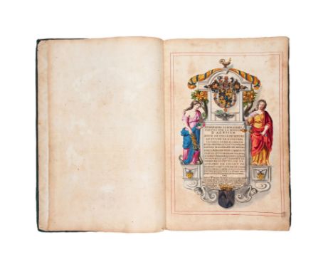
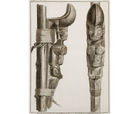
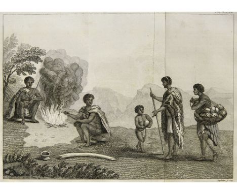
Südsee - Pazifik - - Étienne Marchand. Voyage autour du monde, pendant les années 1790, 1791, et 1792, précédé d'une introduction historique, auquel on a joint des recherches sur les terre australes de Drake, et un examen critique du voyage de Roggeween ... par C. P. Claret Fleurieu. 3 Textbde. u. Atlas in 4 Bdn. Mit 15 (10 gefalt.) Kupferstichkarten, 1 Kupfertafel u. Falttab. XII, CXLIV, 628 S., 2 Bll, Errata, Typogr. Tafel; 2 Bll., 676 S., XVI, Inhaltsverzeichnis, XI, 431 S., 1 Bl., I 2 Bll., VIII, 158 S., 1 Bll., Paris, Impr. de la République, (1798-1800) 1841. 4°. Zweite Aufbindung der Ersten Ausgabe. - Originale Quartausgabe auf großem Papier, die 1841 mit einem neuen Titel mit der fiktiven Erwähnung "Neuausgabe" wieder in den Handel kam (einige wenige Exemplare, die 1798 gedruckt wurden, hatten noch immer keinen Käufer gefunden). Es erschien auch eine sechsbändige Oktavausgabe. Cox I, 68 - Henze III, 370 - Sabin 44491 - Cat. National Maritime Museum 146 - Cat. Scheepvaart Museum 140 - Griep-L. 855 (Anm.) - Dinse 229 - Graesse IV, 382 - "Einzigartig" (Henze). Der krönende Abschluß der großen Reisewerke der Aufklärung über den pazifischen Raum. Verfaßt vom Compte de Fleurieu, dem damals besten Kenner pazifischer Entdeckungsgeschichte, unter Auswertung der Tagebücher von Kapitän Chanal und Schiffsarzt Roblet, besticht der Bericht über die Weltumsegelung Marchands (1755-1793) durch größte historische Genauigkeit und "straffe, vergleichende Zusammenfügung aller damals bekannten geographisch- ethnographischen Daten" (Henze). Ausgeführt im Auftrag einer Marseiller Handelsgesellschaft, sollte die Reise dem Pelzhandel Frankreichs mit dem pazifischen Nordamerika dienen. Marchands Expedition erforschte mehrere ozeanische Inselgruppen und erreichte die nordamerikanische Küste bei über 50° Nord. - Eindrucksvoller und umfassender Bericht der zweiten französischen Weltumsegelung und die erste französische Handelsreise in den pazifischen Nordwesten. Etienne Marchand, Leiter der Expedition, hatte vom britischen Kapitän Portlock vom lukrativen Potenzial für den Pelzhandel in dieser Region erfahren. Er segelte über Kap Hoorn, machte bei den Marquesas Halt und handelte und segelte im Sommer 1791 entlang der Nordwestküste. Er liefert detaillierte Beschreibungen von Norfolk Sound und Sitka, gefolgt von einem besonders detaillierten Bericht über die Queen-Charlotte-Inseln und weiteren Erkundungen bis zum südlichen Ende von Vancouver Island. "Ein sehr wichtiges und maßgebliches Werk für die Geschichte der Nordwestküste" - (Vgl. Lada-Mocarski). Von Nordamerika segelte Marchand nach Hawaii und dann nach Macao. Auf den Marquesas Inseln nahm Marchand zwei Inseln in Besitz, Uapou und Nukuhiva (die er Ile Baux nannte), ohne von Ingrahams Besuch auf der "Hope" zwei Monate zuvor zu wissen. Dann kehrte er nach Frankreich zurück, wo die Revolutionsregierung seine Ladung Pelze, die nicht verkauft werden konnte beschlagnahmte. Die Reise war ein Verlust für seine Investoren (Vgl. Forbes). Marchand starb 1793, und Graf Fleurieu, selbst ein erfahrener Pazifikforscher, übernahm die Redaktion und Veröffentlichung der Manuskripte der Reise und fügte eine maßgebliche Historiographie der Pazifikforschung und der Entdeckungen an der amerikanischen Küste hinzu. Ein beträchtlicher Teil des Textes ist der Erforschung der Naturgeschichte während der Reise gewidmet: "un vaste travail de compilation, où les observations géographiques, nautiques, ethnographiques et zoologiques sont confrontées avec celles des voyages espagnols (Mendaña, Quiros), hollandais (Roggeween), anglais et américains (Cook, Ingraham, Roberts, Hergest)" (Vgl. O'Reilly, Bibliographie de Tahiti). Der letzte Band enthält eine kritische Analyse von Roggeveens Reise, und die detaillierten Karten von Alaska und der Nordwestküste (5), vier von den Marquesas Inseln (Französisch Polynesien) und eine Karte von Hawaii, während die Karte des Chinesischen Meeres wichtige Korrekturen enthält. - Gute Exemplare Second binding of the first edition. Original quarto edition on large paper, which came back into circulation in 1841 with a new title with the fictitious mention "new edition" (a few copies printed in 1798 still had not found a buyer). A six-volume octave edition was also published. - 4 vols. including atlas. With 15 (10 folding) engraved maps, 1 engraved plate, and folding table. - Fine contemp red half leather with gilt edges, spine richly gilt. - Unique; brilliant; comprehensive (Henze). Marchand's circumnavigation in eighteen months was promoted by the French commercial firm of Baux at Marseilles, to secure furs from the American Northwest coast. The narrative was drawn up by Fleurieu from the journal of Captain Chanal, the second in command of the expedition. - Original edition put back on sale in 1841 with a relay title bearing the fictitious mention "New Edition" (a few copies printed in 1798 had still not found a buyer). Impressive and comprehensive report of the second French circumnavigation of the world and the first French trade voyage to the Pacific Northwest. Etienne Marchand, head of the expedition, had learned from British Captain Portlock about the lucrative potential for the fur trade in this region. He sailed via Cape Horn, stopped at the Marquesas and traded and sailed along the northwest coast in the summer of 1791. He provided detailed descriptions of Norfolk Sound and Sitka, followed by a particularly detailed report on the Queen Charlotte Islands and further exploration to the southern end of Vancouver Island. "A very important and authoritative work for the history of the Northwest Coast" - (Cf. Lada-Mocarski) From North America Marchand sailed to Hawaii and then to Macao. On the Marquesas Islands, Marchand took possession of two islands, Uapou and Nukuhiva (which he called Ile Baux) without knowing of Ingraham's visit to the "Hope" two months before. He then returned to France where the revolutionary government confiscated his cargo of furs that could not be sold. The trip was a loss for his investors (see Forbes). Marchand died in 1793, and Count Fleurieu, himself an experienced Pacific explorer, took over the editing and publication of the voyage's manuscripts, adding an authoritative historiography of Pacific exploration and discoveries on the American coast. A considerable part of the text is dedicated to the study of natural history during the voyage: "un vaste travail de compilation, où les observations géographiques, nautiques, ethnographiques et zoologiques sont confrontées avec celles des voyages espagnols (Mendaña, Quiros), hollandais (Roggeween), anglais et américains (Cook, Ingraham, Roberts, Hergest)" (cf. O'Reilly, Bibliography de Tahiti). The last volume contains a critical analysis of Roggeveen's voyage, and the detailed maps of Alaska and the northwest coast (5), four of the Marquesas Islands (French Polynesia), and a map of Hawaii, while the map of the China Sea contains important corrections. - Good copies

Lot 65

Afrika - - Besitzstands-Karte von Deutsch-Südwestafrika in 3 Blättern. Maßstab 1:800,000. Stand am 1. Oktober 1911. Bearbeitet im Bureau der Kaiserlichen Landesvermessung. Berlin, Reimer (Vohsen), (1912). 2 x 10 und 1 x 12 Segmente (Format je ca. 32 x 24 cm) auf Lwd. aufgezogen. Format je Blatt ca. 123 bzw. 147 x 64 cm. Gefalt. in Lwd.-Mappe d. Zt. mit mont. Titel auf VDeckel u. Bindebändern (etwas berieben u. angeschmutzt). Sehr selten. Im Handel nicht nachweisbar. 4 Treffer in Worldcat. - Kolorierte lithographische Karte in 3 Teilen (Nordblatt (Angola), Mittelblatt (Britisch Betschuana Land), Südblatt (Kap-Land). - Exlibris, die 3 Teile jeweils mit 3 Metallösen zum Aufhängen versehen (angerostet), tls. etwas stockfleckig, 1 kl. Läsur, stellenw. etw. berieben, insg. gut erhalten. Very rare coloured lithogr. map in 3 parts (2 x 10, and 1 x 12 segments mounted on cloth). Fold. In contemp. cloth folder with ties and mounted title to front board (some rubbing and soiling). - Bookplate, each part with 3 metal loop hangers (slightly rusty), some foxing, 1 small defect, occ. slight rubbing, overall good condition.

Lot 69

Afrika - - William Paterson. Wilhelm Patterson's Reisen durch das Land der Hottentotten und der Kaffern in den Jahren 1777, 1778 und 1779. Aus dem Englischen übersetzt und mit Anmerkungen begleitet von Johann Reinhold Forster. Mit 15 (2 gefalt.) Kupfertafeln u. 1 gestoch. gefalt. Karte. Berlin, 1790. 7 Bl., 170 S., 1 Bl. 8°. Dekor. HLdr. d. Zt. mit Rotschnitt, 2 goldgepr. RSchildern u. reicher RVerg. (etwas angeschmutzt, berieben u. bestoßen). Erste Ausgabe der seltenen deutschen Übersetzung der "Narrative of Four Journeys into the Country of the Hottentots, and Caffraria" (London 1789) von William Patterson (1755-1810). - Die Kupfertafeln mit ethnographischen und botanischen Darstellungen, die Karte zeigt die südliche Spitze von Afrika. - Besitzeintrag, Exlibris, 1 Textbl. mit Fleck, Karte mit kl. Randeinriss, sonst insg. wohlerhalten. First edition of the rare German translation. With 15 (2 fold.) copper engraving plates and 1 fold. engr. map. Contemp. half leather with red edges, 2 gilt stamped labels to spine and rich spine gilt (some soiling, rubbing, and bumping). - The plates with botanical and ethnographic illustrations, the map shows the southern land tongue of Africa. - Ownership entry, bookplate, 1 text leave with stain, map with small margibal tear, otherwise overall well preserved.

Lot 124

Schweiz - - Johannes Stumpf. Gemeiner loblicher Eydgnoschafft Stetten, Landen und Volckeren Chronic wirdiger thaaten beschreibung ... Teile 5-13 in 1 Band. Mit 9 Holzschnittkarten (davon 8 ganzseitig u. 1 doppelblattgroß), mehr als 500 Holzschnittabbildungen im Text und zahlreichen Wappenholzschnitten (davon 13 blattgroß). (Zürich, Chr. Froschauer, 1548). 467 num. Bl., 10 nn. Bl. Folio. Prachtvoller Lederband der Zeit auf 4 Bünden und Holzdeckel mit reicher Rollstempelornamentik mit christlichen Motiven u. Bildnisse von Martin Luther und Philipp Melanchthon, 2 Deckel- u. 8 Eckbeschläge mit Nieten u. Akantusblättern und 2 Metallschließen (hinterer Deckel fleckig, kleine Fehlstelle am Rücken und hinteren Deckel, vorderer Deckel minimal wurmstichig). Zweiter Teil der ersten Ausgabe. - VD 16 S 9864. - BM STC German 839. - Vischer C 396. - Barth 10216. - Haller IV, 396. - Lonchamp 2819. - Feller/B. S. 180 ff. - Leemann-van Elck, Froschauer S. 106ff. - Zweiter Teil der bedeutendsten gedruckten Schweizer Chronik des 16. Jahrhunderts mit mit den großartigen Holzschnitten von Hans Asper, Heinrich Vogtherr, Rudolf und Johann Wyssenbach u.a. Dieser Teil behandelt die historisch-topographische Beschreibung der einzelnen Orte bis 1540, die Stumpff auf Grund seines Aktenstudiums und seiner anlässlich einer ausgedehnten Schweizerreise (1544) gemachten Studien darlegt. "Mit dieser Chronik erreicht die Reihe der schweizergeschichtlichen Druckwerke ihren Höhepunkt, sie zeichnet sich durch eine bis anhin nie gebotene Fülle an hochwertigem Bildschmuck aus. Sie überbietet darin selbst die berühmte 1493 in Nürnberg erschienene Weltchronik von Hartmann Schedel. (...) die Fülle der Abbildungen ist überwältigend" (L.-v. E.). - Beigelegt: 2 Autographen von alter Hand. - Karte Bl. 277 abgerissen (mit Klebeband unprofessionel befestigt), Besitzstempel auf Spiegel und Bl. 200, Eintragungen von alter Hand auf Spiegel u. Vorsatzblatt recto, einige Blätter eingerissen, wenige Seiten mit Fehlstellen am Rand (Bl. 74 u. 298 mit kleinem Textverlust). Bl. 108 mit Tintenfleck, Bl. 2-3 mit größeren Braunflecken, durchgehend etwas gebräunt. Insg. noch in gutem Zustand. Part 2 in first edition. - With 9 woodcut maps (8 full-page and 1 double-page sized), more than 500 woodcut illustrations in text and numerous woodcuts with coats of arms (13 of them in full-page size). - Splendid contemporary leather over wooden boards with 4 raised bands, with rich blindtooling representing christian motives, Martin Luther and Philip Melanchthon, 2 metal clasps (back cover stained, small missing parts on spine and back cover, front cover slightly wormed). - Second part of the most important printed Swiss chronicle of the 16th century with the magnificent woodcuts by Hans Asper, Heinrich Vogtherr, Rudolf and Johann Wyssenbach and others. This part deals with the historical-topographical description of the single places up to 1540, which Stumpff presents on the basis of his studies made on the occasion of an extended trip to Switzerland (1544). - Enclosed: 2 old autographs. - Map sheet 277 torn (fixed unprofessionally with tape), ownership stamp on mirror and sheet 200, entries by old hand on the endpapers, some sheets with tears, some pages with missing parts at margins (sheets 74 and 298 with small loss of text). P. 108 with ink spot, throughout a little bit brownish. All in all in good condition.

Loading...Loading...
  • 109182 item(s)
    /page

Recently Viewed Lots