We found 109182 price guide item(s) matching your search
There are 109182 lots that match your search criteria. Subscribe now to get instant access to the full price guide service.
Click here to subscribe- List
- Grid
-
109182 item(s)/page


![LATE 17TH/EARLY 18TH CENTURY MAP OF INDIA,'L'Inde de la le Gange Suivant les Nouvelles Observations [...]', published Pierre](https://cdn.globalauctionplatform.com/028bf106-e0bf-410a-bbb3-ade400c375ab/6eacc617-f4d9-4489-a57e-aed700cef6b8/468x382.jpg)
![EARLY 17TH CENTURY MAP OF SUSSEX,by John Speed, 'Sussex described and divided [...]', circa 1610, later hand coloured, with A](https://cdn.globalauctionplatform.com/028bf106-e0bf-410a-bbb3-ade400c375ab/8968008b-9153-42ef-b6a2-aed700cef428/468x382.jpg)

![MID-17TH CENTURY DUTCH MAP OF THE BRITISH ISLES,'Pas-Caart van T Canaal [...] T'Amsterdam, Bij Hendrick Doncker [...]', later](https://cdn.globalauctionplatform.com/028bf106-e0bf-410a-bbb3-ade400c375ab/7baa9967-5e94-4d76-8d7b-aed700d1cf9d/468x382.jpg)

![EARLY 18TH CENTURY MAP OF SCOTLAND,by Peter Schenk, Novisima Regni Scotiae [tabula]', circa 1708, 57.5cm x 49cm, mounted, fra](https://cdn.globalauctionplatform.com/028bf106-e0bf-410a-bbb3-ade400c375ab/1612fed6-30e0-43e4-83ad-aed700d1e4cd/468x382.jpg)

Lot 77
COLLECTION OF FIFTEEN BRITISH AND OVERSEAS MAPS,circa 17th to 19th century, engraved maps, including Morden (Robert), The East Riding of London [and] South Wales, [1695 or later], two hand coloured engraved maps, each approximately 360 x 430 mm, together with Kitchin (Thomas), Cornwall drawn from an actual survey..., circa 1760, uncoloured engraved map, 200 x 235 mm, with Schmollinger (William)), Environs of London, circa 1836, hand coloured engraved oval map of London, 200 x 240 mm, plus Porcacchi (Tomaso), Candia, [1572 or later], hand coloured engraved map, Italian text below and on verso of map, map size 110 x 145 mm, with another ten maps, including examples by Moule, Kitchin, Hogenberg, Van en Keere, Ogilby, Cary and Beighton, various sizes and conditionA Private Scottish Highlands CollectionAn original and period map(s)


Lot 93
THREE BOOKS,comprising Sikhim and Bhutan by White (J. C.), pub. Edward Arnold, London 1909, with map, in green cloth boards; A Time of Gifts by Fermor (P. L.), signed with dust jacket, pub. John Murray, London 1978; Road to Rakaposhi by Band (G.), signed with dust jacket, pub. Hodder and Stoughton, London 1955 (3)Sikhim and Bhutan likely rebound, additional images available


Lot 100
British County Maps. A collection of 80 maps, 16th - 19th century, engraved county maps, road maps and maps of the British Isles, including Magini (Giovanni). Tabula Europae Prima [and] Britanicae Insulae, Venice, circa 1596, two uncoloured engraved Ptolemaic maps, one on a trapezoidal projection, each approximately 135 x 180 mm, Latin text on verso, together with Bill (John). Shropshire [1626], uncoloured engraved map, slight toning, 90 x 125 mm, English text on verso, with another 77 British county and road maps by or after Blome, Moule, Phillips, Van den Keere, Owen & Bowen, Seller/Grose, Owen & Bowen, Perrot, Mercator/Hondius (small format), Whittaker, A. & C. Black and Lewis, occasional duplicates, various sizes and conditionQTY: (approx. 80)

Lot 101
British County Maps. A collection of approximately 100 maps, 17th - 19th century, engraved and lithographic county maps, road maps and town plans, including examples by or after, Jansson, Moule, Blome, Cary, Fullarton, Dawson, Bacon, Lewis, Archer, Duncan, Hall, Cole & Roper, Langley, Saxton/Hole, Bartholomew, Dower, Morden, Owen & Bowen, Mercator/Hondius (small format), Conder, Badeslade & Toms, Van Langeren, Paterson/Mogg, Seller/Grose and Nichols, occasional duplicates, together with another 9 foreign maps, including Robert Sayer's large scale two-sheet map of Europe, various sizes and conditionQTY: (approx.110)

Lot 102
British Isles. Boisseau (Jean). Carte generalle de la Grande Bretagne jadis Albion et du Royaume d'Irlande ou Hybernie avec les Isles circonuoisines despandantes des dits Royaumes, Paris, 1644, hand-coloured engraved map, inset map of the Orkney islands, two blocks of descriptive text, 380 x 510 mmQTY: (1)NOTE:R. W. Shirley, Early Printed Map of the British Isles, no. 535. An uncommon map, separately published and derived from the outline used by Johannes Blaeu, but with very different decorative features and cartouche

Lot 103
British Isles. Danckerts (Justus). Novissima et Accuratissima Totius Angliae Scotiae et Hiberniae Tabula..., Amsterdam, circa 1690, engraved map with contemporary outline colouring, some oxidisation to old watercolour causing cracking and flaking, repaired on verso, lower margin extended, 500 x 580 mm, together with Accuratissima Angliae Regni et Walliae Principatus Descriptio..., circa 1700, engraved map with contemporary outline colouring, central fold strengthened and repaired on verso, lower margin extended, 505 x 530 mmQTY: (2)NOTE:Rodney W. Shirley, Printed Maps of the British Isles 1650 - 1750. Danckerts 2, state 3 & Danckerts 3.
![British Isles. Jansson (Jan & Hondius Henricus), Magnae Britanniae et Hiberniae Tabula, 1631 [or later], hand-coloured en](https://cdn.globalauctionplatform.com/7857d780-0570-41b1-a879-aebc011e27de/bd484017-6ba2-4815-ada5-aecc011ad8b7/468x382.jpg)
Lot 105
British Isles. Jansson (Jan & Hondius Henricus), Magnae Britanniae et Hiberniae Tabula, 1631 [or later], hand-coloured engraved map, inset map of the Orkney Islands, decorative cartouche and mileage scale,380 x 510 mm, mounted, framed and glazedQTY: (1)NOTE:R. W. Shirley. Early Printed Maps of the British Isles, 1477 - 1650, no. 435.

Lot 107
British Isles. Lotter (Tobias Conrad), La Grande Bretagne ou Les Royaumes D'Angleterre et D'Ecosse comme aussi le Royaume D'Irlande Divisée par Provinces..., Augsburg, circa 1764, engraved map with bright contemporary hand-colouring, large uncoloured allegorical cartouche and three heraldic shields representing the three nations in the upper left corner, 495 x 580 mm, together with Sanson (Nicolas). Le Royaume D'Angleterre distingué en ses Provinces..., Paris, H. Jaillot, 1693, engraved map with contemporary hand colouring and some later enhancement to the the cartouche and mileage scale, title repeated above the map, slight staining, 790 x 585 mmQTY: (2)NOTE:The second map described. R. W. Shirley, Printed Maps of the British Isles 1650 - 1750, Jaillot 2 state 1.

Lot 108
British Isles. Seutter (Matthaus), Tabula Novissima Accuratissima Regnorum Angliae, Scotiae, Hiberniae..., Augsburg, circa 1736, engraved map with contemporary hand colouring, uncoloured cartouche, mileage scale and heraldic shields, slight staining to the upper right margin, 580 x 495 mm, together with Britanniae sive Angliae regnum tam secundum prisca Anglo-Saxonum Imperia..., Augsburg, circa 1740, engraved map with contemporary outline colouring with some later enhancement to the cartouche, 575 x 500 mmQTY: (2)NOTE:R. W. Shirley. Printed Maps of the British Isles 1650 - 1750. Seutter 1. state 2. [and] Seutter 2, state 2.
Lot 11
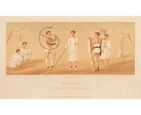
Gell (William, and John P. Gandy). Pompeiana. The Topography, Edifices, and Ornaments of Pompeii, 2nd edition, London: printed for Rodwell and Martin, 1821, half title, additional engraved title, 80 engraved maps, plates and plans including a colour and bistre plate, errata slip tipped-in at end (with tears), double-page plan at front torn without loss, some light offsetting and spotting, rear hinge broken, bookplate of William Dowdeswell (1804-1870, Conservative politician), Pull Court, Worcestershire, contemporary half morocco, joints and edges rubbed, large 8vo, together with Evans (Arthur J.) Through Bosnia and the Herzegovina on Foot, 1st edition, London: Longmans, Green and Co., 1876, folding map, wood-engraved illustrations, publisher's catalogue at end, Cobham Hall Estate Library stamp to front endpaper verso, front hinge breaking, original cloth gilt, upper joint split, lower joint splitting, spine a little faded and rubbed at ends, 8vo, plus Forester (Thomas, editor). Norway and its Scenery. Comprising the Journal of a Tour by Edward Price, Esq. With considerable additions and a road-book, with hints to anglers and sportsmen, 1st edition, London: Henry G. Bohn, 1853, 21 mezzotint plates, frontispiece detached, endpapers a little toned, previous owner signature, original cloth, spine toned, slight fading, 8vo, together with William Hepworth Dixon's Free Russia, 2 volumes, 3rd edition, 1870 QTY: (5)
![British Isles. Waldseemuller (Martin), Untitled map of the British Isles, Melchior & Gaspar Treschel, Lyons [1535], uncol](https://cdn.globalauctionplatform.com/7857d780-0570-41b1-a879-aebc011e27de/08e7f9fb-7ce7-4c99-991d-aecc011adc12/468x382.jpg)
Lot 110
British Isles. Waldseemuller (Martin), Untitled map of the British Isles, Melchior & Gaspar Treschel, Lyons [1535], uncoloured woodblock map on a trapezoidal projection, 300 x 440 mm, Latin text on versoQTY: (1)NOTE:R. W. Shirley. Early Printed Maps of the British Isles. Number 24. A further issue of number 15 - the Lorenz Fries edition of 1522 - with a reverse title of 'Europae Regionum'.
Lot 111
British Isles. Wells (Edward), A New Map of the British Isles, Shewing their Present Genl. Divisions, Cities and such other Towns or Places..., circa 1700, hand-coloured engraved map, 380 x 500 mm, together with Sanson (Nicolas), Brtiannicae Insulae in quibus Albium sive Britannia Major Ivernia sive Britannia Minor tum et Orcades, Ebudes Cassiterides..., M. Tavernier, Paris, 1641, engraved map with contemporary outline colouring, 400 x 530 mm, with Laurie (Robert & Whittle James, publishers). Britanniae Antiquae Tabula Geographica ex Aevi Romani Monumentis..., 1794, engraved map with contemporary outline colouring, slight staining, 555 x 505 mm, plus Migeon (J. publisher). Iles Britanniques, Paris circa 1850, engraved map with contemporary outline colouring, inset map of the Shetland Islands and two uncoloured vignettes of the Thames Tunnel and the Tower of London, 405 x 295 mm, and a folding engraved map of Yorkshire and a map of the Isle of Man and the Channel Islands by John Cary, various sizes and conditionQTY: (7)
![Buckinghamshire. Speed (John), Buckingham Both Shyre and Shire Towne describ. Roger Rea [1662], hand-coloured engraved map, i](https://cdn.globalauctionplatform.com/7857d780-0570-41b1-a879-aebc011e27de/3d32e1d0-86c3-4568-aa63-aecc011add7c/468x382.jpg)

Lot 117
Cardiganshire. Speed (John), Cardigan Shire Described with the due forme of the Shiretown as it was surveyed by J. S. Anno 1610, Roger Rea [1662], uncoloured engraved map, slight dust soiling, 385 x 510 mm, English text on verso, mounted, together with Merioneth Described, George Humble, circa 1627, uncoloured engraved map, slight 'show-through' 380 x 510 mm, English text on verso QTY: (2)

Lot 118
Celestial Chart. Homann (Johann Baptiste), Hemisphaerium Coeli Australe, Nuremberg, circa 1730, hand-coloured celestial chart after J. G. Doppelmayr, with tables to the vertical margins listing the names of constellations and the magnitudes and coordinates of stars within, hemispheres flanked by putti holding astronomical instruments, some water staining, occasional repaired marginal closed tears, 490 x 580 mmQTY: (1)NOTE:The map is an example of one of a number of collaborations between Dopplemayr and Homann gathered together for inclusion in the 'Atlas Novus Coelestis in quo Mundus Spectabilis'.
![Channel Islands. Von Reilly (Franz Johann Joseph), Die Insel Jersey [and] Die Englaendischen Inselin an der Küste von Frankre](https://cdn.globalauctionplatform.com/7857d780-0570-41b1-a879-aebc011e27de/5ec855bf-68e5-4f34-86e6-aecc011ae250/468x382.jpg)
Lot 119
Channel Islands. Von Reilly (Franz Johann Joseph), Die Insel Jersey [and] Die Englaendischen Inselin an der Küste von Frankreich, Vienna, circa 1799, together two engraved maps with contemporary outline colouring, each approximately 205 x 340 mm, mounted, together with Collins (Captain Greenville). Untitled sea chart of the western tip of Cornwall and the Scilly Isles, circa 1790, hand-coloured engraved sea chart, 455 x 575 mm, with Sayer (Robert & Bennett J., publishers). A New Chart of Mounts Bay in Cornwall with the Adjacent Coast from Cape Lizard to Cape Cornwall, 1780, hand-coloured engraved sea chart, compass rose and numerous rhumb lines, five inset horizon profiles, 490 x 695 mm, plus Bonne (Rigobert). Carte Particuliere des Isles Jersey, Grenesy et Aurigny, circa 1770, engraved miniature map with contemporary outline colouring, inset map of Alderney, 105 x 130 mm, with two other similar by or after Lewis and Millar, various sizes, good condition QTY: (7)


Lot 121
Cuba. Ruscelli (Girolamo), Isola Cuba Nova, Venice, circa 1561 uncoloured engraved map, slight toning to the central fold, 190 x 260 mm, Italian text on versoQTY: (1)NOTE:One of the earliest separately published maps of Cuba. The map also shows Jamaica and northwestern Hispaniola and the Cayman Islands. Based on an earlier map of 1548 by Gastaldi.
Lot 123
England & Wales. A collection of 60 Maps, 18th & 19th century, engraved and lithographic maps, including examples by or after Rapkin, Archer, Virtue, Walker, Wilkes, Wilkinson, Whittaker, Weigel, Laurie, Langley, Leigh, Lucas, Lizars, Kitchin, Tindall, Thomson, Paterson, Wyld, Andrews, Perrot, Arrowsmith, Morden, Moll, Mackenzie, Meyer and Lewis and one manuscript map of England & Wales, occasional duplicates, various sizes, good conditionQTY: (60)

Lot 124
England & Wales. Allard (Carol), Regni Angliae et Walliae Principatus Tabula..., J. Covens & C. Mortier, Amsterdam, circa 1730, engraved map with contemporary outline colouring and some later enhancement to the cartouche, 505 x 590 mm, together with Regnum Magnae Britanniae sive Angliae, Scotiae nec non Hiberniae Nuperrima Delineatio..., circa 1721, engraved map with contemporary outline colouring, inset map of the Orkney Islands, slight overall spotting and toning, 505 x 590 mmQTY: (2)NOTE:R. W. Shirley, Printed Maps of the British Isles 1650 - 1750, Allard 3 state 2 & Allard. 4 state 3.

Lot 125
England & Wales. Ortelius (Abraham & Lhuyd Humphrey), Angliae Regni Florentissimi nova descriptio auctore Humfredo Lhuyd Denbygiense, circa 1592, engraved map with contemporary hand-colouring and some later enhancement, short split at base of the central fold, repaired on verso, 390 x 475 mm, Latin text on verso QTY: (1)NOTE:Marcel Van den Broecke. Ortelius Atlas Maps, no. 19. R. W. Shirley. Early Printed Maps of the British Isles, no. 98.
Lot 126
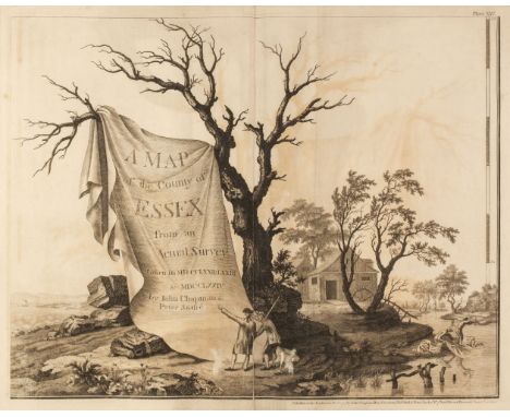
Essex. Chapman (John, and André, Peter). A Map of the County of Essex from an actual survey taken in MDCCLXXII: LXXIII & MDCCLXXIV by John Chapman and Peter André, October 1st, 1777, large-scale engraved map of 25 sheets (complete, including the list of subscribers), plus the double-page key map, large compass rose, inset plan of Harwich Harbour and map of Colchester, slight spotting and offsetting, each sheet approximately 470 x 600 mm, 19th century half morocco gilt, with a heraldic motto and crest to the upper siding, worn and rubbed, folioQTY: (1)NOTE:Chapman and André's meticulously detailed and accurate survey of Essex resulted in the finest large-scale map of the county. It was the first to depict minor roads and included every country house and cottage, milestone, bridge, turnpike, creek, ferry, cliff and even a duck decoy. It is unlikely that more than 300 copies of the first edition were sold, though there was a second smaller edition issued in 1785.The crest on the front cover is that of Joseph Cockfield Dimsdale, 1st Baronet (1849 - 1912), a resident of Essex, knighted in 1894 and was Lord Mayor of London on the occasion of the coronation of Edward VII in 1902. He was created a Baronet and a Knight Commander of the Victorian order and was a Member of parliament from 1900 - 1906. His library was sold by Christie's in April 1913.

Lot 127
Europe. Blaeu (Willem Janszoon), Europa recens descripta à Guilielmo Blaeuw, Amsterdam, circa 1630, engraved carte-a-figures map of Europe with ten costumed figures to the vertical margins and nine oval vignettes of the principal cities displayed along the upper margin, large margins, slight spotting but confined to the margins, 410 x 555 mm, Latin text on versoQTY: (1)NOTE:A striking and highly decorative map in the 3rd state (of 4), with the title cartouche amended but retaining the mythical island of Frisland to the southwest of Iceland. Published in Blaeu's 'Atlas Appendix'.

Lot 128
Europe. Bünting (Heinrich), Europa Prima pars Terrae in Forma Virginis, Magdeburg, 1581, woodcut map with contemporary hand-colouring, heightened in gold, originally published in Bünting's 'Itinerarum Sacrae Scripturae', old folds, vertical margins and central fold professionally restored on verso, Latin text below image, German text on the verso, 270 x 370 mm, mountedQTY: (1)NOTE:Bünting's map is based upon the map of Europa by Sebastian Munster which appeared in his 'Cosmographia'. The map depicts Europe as a Virgin Queen, holding a crown, orb and sceptre. Iberia forms her head and crown; Denmark her right arm and Italy her left arm, with Sicily as her orb. Greece, the Balkans and Russia form her skirts; and Bohemia, positioned in the centre of her torso could be her heart, or, a medallion on a chain around her neck. Scarce.
Lot 13
Hamilton (John, Successor to Daniel Lizars, publisher). The Edinburgh Geographical and Historical Atlas, comprehending a sketch of the History of Geography ... and History of each Continent, State, and Kingdom, delineated and a tabular view of the principal mountain chains in the World, Edinburgh circa 1830, printed title page, contents list, folding engraved plate of a 'Table of Mountain Chains' with a long closed tear along the old fold, 58 engraved double-page and folding maps with contemporary hand-colouring (lacking map 32, correct as list), some maps with offsetting and slight toning, index bound at rear, closed tear and later ownership signatures to the front blank, hinges cracked, marbled endpapers, contemporary half calf gilt, worn at extremities, boards a little rubbed, folioQTY: (1)

Lot 134
Greenwood (C. & J.). Atlas of the Counties of England made from Actual Surveys made from the years 1817 to 1833..., 2 volumes, 1834, calligraphic title with an engraved map of England & Wales, 41 (only) engraved double-page maps, with contemporary outline colouring, each with an ecclesiastical vignette, table of explanation, compass rose and calligraphic title, some damp staining affecting the lower part of the maps, each map re-guarded and backed with linen, slight dust soiling, creasing and spotting, a few maps trimmed to the neatline, map of Durham with long repaired closed tears and a small area of loss, each map approximately 590 x 690 mm, modern half morocco gilt with contrasting calf labels to spines, slight wear to extremities, folioQTY: (2)NOTE:The maps consist of Bedford, Berkshire, Buckinghamshire, Cambridge, Cumberland, Dorset, Durham, Essex, Gloucester, Herefordshire, Hertford, Huntingdon, Kent, Lancaster, Leicester, Lincolnshire, Middlesex, Norfolk, Northampton, Northumberland, Nottingham, Oxford, Rutland, Salop (Shropshire), Somerset, Southampton (Hampshire), Suffolk, Surrey, Sussex, Warwick, Westmorland, Wiltshire, Worcestershire, East Riding of Yorkshire, West Riding of Yorkshire, North Riding of Yorkshire, Glamorgan Brecon & Radnor, Anglesey Caernarfon & Merioneth, Flint Denbigh & Montgomery, Cardigan Pembroke & Caermarthen [and] Monmouth
![Hampshire. Speed (John), Hantshire described and devided, Thomas Bassett & Richard Chiswell [1676], uncoloured engraved m](https://cdn.globalauctionplatform.com/7857d780-0570-41b1-a879-aebc011e27de/764f942f-ba28-405b-94c5-aecc011aefd0/468x382.jpg)
Lot 136
Hampshire. Speed (John), Hantshire described and devided, Thomas Bassett & Richard Chiswell [1676], uncoloured engraved map, inset town plan of Winchester, occasional marginal closed tears, slight spotting, central fold partially split from the lower margin 380 x 510 mm, English text on versoQTY: (1)

Lot 137
Holy Land. Jaillot (Alexis-Hubert), Judaea, seu Terra Sancta quae Hebraeorum sive Israelitarum in suas Duodecim Tribus Divisa..., G. Sanson, Amsterdam, 1691, large format map showing the 12 tribes of Israel, contemporary hand-colouring and some later enhancement to the cartouches, the title cartouche supported by the figures of Moses and Aaron, the mileage cartouche decorated with a depiction of Adam and Eve in the Garden of Eden, title repeated above the map, 575 x 850 mmQTY: (1)

Lot 138
India. Seutter (M.). Imperii Magni Mogolis sive Indici Padschach..., Augsburg, circa 1738, hand-coloured engraved map, large decorative cartouche and mileage scale, 500 x 570 mm, together with Covens (J. & Mortier C.). Carte des Côtes de Malabar et de Coromandel, Amsterdam, circa 1730, hand-coloured engraved map, title repeated above the map in Latin, 475 x 585 mm, with Moll (Herman). India proper, or the Empire of the Great Mogul, circa 1740, hand-coloured engraved map, 260 x 195 mmQTY: (3)

Lot 14
Hodson (T.C). The Nãga Tribes of Manipur, 1st edition, London: Macmillan & Co, 1911, colour frontispiece, half-title, monochrome illustrations, slight dust-soiling, hinges tender, original blue cloth gilt, figure blocked in gilt to front board, slightly rubbed, 8vo, together with:Gregory (C.J). To the Alps of Chinese Tibet, an account of a journey of exploration up to and among the snow-clad mountains of the Tibetan frontier, 1st edition, London: Seeley, Service & Co. limited, 1923, monochrome frontispieces, folding map to rear, monochrome illustrations throughout, advertisements to rear, lightly spotted, original orange pictorial cloth, worming to spine base, worn, 8vo, Russell (William Howard). A Diary in the East during the tour of the Prince and Princess of Wales, 1st edition, London: George Routledge and Sons, 1869, chromolithographic frontispiece, chromolithographic plates, further illustrations to text, lightly spotted, front hinge tender, original red cloth gilt, rubbed and shaken, 8vo, with 13 others related including 3 volumes of the Asiatic Register (1799-1801)QTY: (16)

Lot 140
Indian Ocean. Bertelli (Ferrando), Seconda Ostro Tavola, Venice, circa 1565, uncoloured map engraved by Niccolo Nelli (to whom the map is sometimes attributed), the map is inverted and shows India, Arabia, the Maldives, Persia and Pakistan, thread margins, laid on later wove paper, some water staining to the backing paper, 280 x 390 mmQTY: (1)NOTE:A rare map from the Antonio Lafreri school. The map is based upon Ramusio's map of 1554, which appeared in his 'Delle Navigation e Viaggi' and updates Gastaldi's map of 1548.
![Ireland. Speed (John), The Province of Connaugh with the City of Galwaye, Thomas Bassett & Richard Chiswell [1676], hand-](https://cdn.globalauctionplatform.com/7857d780-0570-41b1-a879-aebc011e27de/0d097033-e198-4e97-80c9-aecc011af316/468x382.jpg)
Lot 141
Ireland. Speed (John), The Province of Connaugh with the City of Galwaye, Thomas Bassett & Richard Chiswell [1676], hand-coloured engraved map, inset town plan of Galway, large strapwork cartouche, compass rose and mileage scale, slight worming to the lower margins, 385 x 510 mm, English text on verso, mounted, framed and double-glazedQTY: (1)

Lot 142
Irish Sea. Van Keulen (Johannes), Nieuwe Pas-Kaert vande Oost Kust van Yrland, d, Beginnende van de Hoeck van Waterfoort tot aen de Mayds, als mede de West Kust van Engeland van S. David tot Moul van Galoway..., Amsterdam, circa 1680, hand-coloured engraved sea chart orientated to the east, large decorative cartouche and mileage scale, very slight staining, 505 x 585 mm, together with Depot de la Marine (publisher). Carte Particuliere de la Mer D'Irlande appellée communement Canal St. Georges..., circa 1805, large hand-coloured engraved sea chart, 885 x 610 mm, with another uncoloured example (blue-backed) dated 1797, with an ink library stamp to the lower right, plus Bellin (Jacques Nicolas). Carte du Canal de S. Georges ou Mer D'Irlande..., 1757, hand-coloured engraved sea chart based on an earlier map by Captain Greenville Collins, trimmed with slight loss to the lower printed margin, 445 x 580 mmQTY: (4)

Lot 143
Isle of Wight. Blaeu (Johannes), Vectis Insula Anglice, The Isle of Wight, Amsterdam, circa 1660, engraved map with contemporary outline colouring, slight creasing, slight staining but confined to the margins, slight 'bleeding' of old watercolour, 385 x 505 mm, Spanish text on verso, together with Haywood (John). A Map of the Isle of Wight..., 1781, engraved map with contemporary outline colouring, slight staining, repaired closed tears affecting the printed image, old folds, strengthened on verso, 495 x 595 mm, with Bellin (Jacques Nicolas). Carte de L'Isle de Wight, circa 1764, engraved map with contemporary outline colouring, 230 x 360 mm, plus Van den Keere (Pieter). Wight Island, circa 1627, hand-coloured engraved map, 85 x 125 mm, English text on verso, with another six maps of the Isle of Wight, including examples by or after Moule, Kitchin, Sayer, Hermannides and 'The Illustrated London News', various sizes and condition, and Buck (S. & N.). The West View of Cows Castle in the Isle of Wight, 1733, uncoloured engraved panorama, 190 x 370 mm, QTY: (11)

Lot 144
Japan & Korea. A collection of seven maps, 18th & 19th century, including Zatta (Antonio). L'Impero del Giapon Diviso in Sette Principali Parti..., Venice, circa 1785, engraved map with contemporary outline colouring and some later enhancement to the cartouche, 330 x 425 mm, together with Albrizzi (Giambatista). Imperio del Giappone, circa 1740, hand-coloured engraved map, 255 x 335 mm, with Sanson (Guillaume). De Eilanden van Japan, circa 1705, uncoloured map, engraved by A. D' Winter and originally published in 'Algemeene Weereldtbeschryving', 190 x 245 mm, plus Bellin (Jacques Nicolas). Carte des Isles du Japon et la Presqu'Isle de Coree avec les Costes de la Chine..., [and] Carte de la Province de Quan-tong ou Lyau-tong et du Royaume de Kau-Li ou Corée..., circa 1760, together two hand coloured engraved maps, old folds, each approximately 215 x 295 mm, and Thomson (John & Co. publishers). Corea and Japan, 1815, double-page engraved map with contemporary outline colouring, 510 x 635 mm, with Bellin (Jacques Nicholas). Plan de Jedo, circa 1750, uncoloured engraved city plan, old folds, 255 x 255 mmQTY: (7)

Lot 146
Kent. Lea (Philip), To His Grace ... John Tillotson ... Lord Archbishop of Canterbury ... this New Map of Kent, is Most Humbly Presented and Dedicated by P. Lea, circa 1693, engraved map with contemporary outline colouring, inset map of Canterbury and decorated with 8 heraldic shields, central fold discoloured and strengthened and repaired on the verso, 415 x 530 mm QTY: (1)

Lot 148
Livonia. Mercator (Gerard), Livonia, circa 1595, engraved map with contemporary outline colouring, large strapwork cartouche, 365 x 475 mm, mounted, framed and glazed, together with another later example from circa 1636, mounted, framed and glazed, with De Wit (Frederick). Ducatuum Livoniae et Curlandiae nova Tabula..., circa 1720, engraved map with contemporary hand colouring, 420 x 500 mm, mounted, framed and glazed, plus Hondius (Jodocus). Livonia, circa 1625, hand-coloured engraved map with English text above and below the map, map size 150 x 190 mm, mounted, framed and glazed, with three other small-scale maps of Livonia by Ortelius and De La Feuille (one duplicate), various sizes, good conditionQTY: (7)

Lot 149
London. Weller (Edward), London, circa 1863, uncoloured lithographic map on nine double-page sheets, some spotting, each sheet approximately 475 x 640 mm, bound in contemporary half morocco gilt, worn and rubbed, spine with small area of loss, slim folioQTY: (1)NOTE:Originally published in 'The Dispatch Atlas'

Lot 150
Maps. A mixed collection of 22 maps, 17th - 19th century, British and foreign maps, including Blome (Richard). To the Hon.ble Sr. Robert Vyner of the Citty of London, Alderman, Kt. and Baronet..., [1673], hand-coloured map, etched by Wenceslaus Hollar, decorated on three margins by the arms of livery companies, slight spotting, 175 x 280 mm, mounted, framed and glazed, together with Blaeu (Johannes). Monumethensis Comitatus vernacule Monmouth Shire, Amsterdam, circa 1648, hand-coloured engraved map, large decorative cartouche and mileage scale, some spotting and dust soiling, 380 x 500 mm, framed and double-glazed, Latin text on verso, with Morden (Robert). Derbyshire, Oxfordshire, Northamptonshire, Leicestershire (2 copies) and Staffordshire [1685 or later], together six hand-coloured engraved maps, some staining and spotting, four framed and glazed, each approximately 360 x 415 mm, plus another fifteen unframed maps of British counties and foreign countries and regions, including examples by or after Pigot, Cary, Moule, Seller/Grose, Cowley, Schmolliger, Lewis, Neele, Visscher and Brion de la Tour, various sizes and conditionQTY: (22)

Lot 155
Middlesex. Speed (John), Midle-Sex Described with the most famous Cities of London and Westminster, Thomas Bassett & Richard Chiswell [1676], uncoloured engraved map, inset town plans of Westminster and London, inset views of Saint Peters and Saint Pauls, small closed tear in the lower margin but not affecting the printed image, short split along the central fold, 385 x 515 mm, English text on versoQTY: (1)

Lot 157
Monmouthshire. Speed (John), The Countye of Monmouth with the situation of the Shire-Towne Describe, Thomas Bassett & Richard Chiswell [1676], hand-cloured engraved map, inset town plan of Monmouth, large strapwork cartouche and mileage scale, slight staining, 385 x 510 mm, English text on versoQTY: (1)
Lot 159
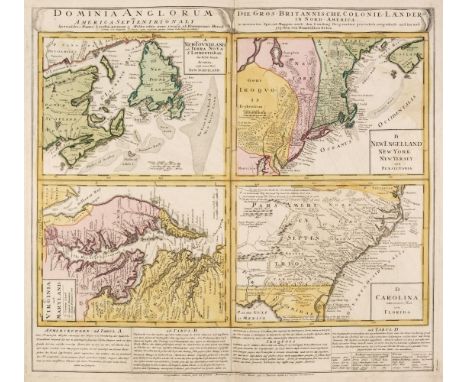
North America. Homann (Johann Baptiste), Dominia Anglorum in America Septentrionali..., circa 1740, four engraved maps on one sheet (Virginia & Maryland, New England, Carolina, Newfoundland & Nova Scotia), contemporary hand colouring, title repeated in Latin & German, very slight dust soiling and staining, 510 x 560 mm, together with Robinson (G. G. & J. publishers). Chart of the North West Coast of America explored by Boussole & Astrolabe in 1786, 3rd Sheet [but published circa 1798], an engraved chart showing San Francisco, sparse outline colouring, old folds, published as a reduced English edition of a La Perouse chart, 395 x 495 mm, with Albrizzi (Giambatista). Carta Geografica del Messico o sia della Nuova Spagna, Venice, circa 1750, hand-coloured engraved map, 335 x 445 mm, plus Bonne (Rigobert). Carte de la Partie Sud des Etats Unis de L'Amerique Septentrionale, Paris, circa 1780, uncoloured engraved map, slight spotting, 220 x 325 mm, with another nine maps and charts of North America, including examples by or after Buffon, J & C Walker (S. D. U. K. atlas), U. S. Coastal Survey charts, Cook charts and Le Sage, various sizes, good conditionQTY: (13)
Lot 160
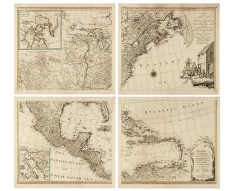
North America. Lotter (M. A. & G. F.). A New and Correct Map of North America, with the West India Islands. Divided According to the last Treaty of Peace, concluded at Paris, the 20th. of Jan. 1783 wherein are particularly Distinguished the Thirteen Provinces wich (sic) Compose the United States of North America..., large engraved four-sheet wall map (not conjoined) with contemporary outline colouring, inset maps of Baffin & Hudson Bays and the Kino map of the land passage to California, compass rose and table of explanation, large uncoloured title cartouche of a wharf scene with merchants supervising slaves moving cargo, large margins, slight dust soiling, but confined to the margins, each sheet approximately 510 x 585 mm, if joined approximately 1020 x 1170 mm QTY: (4)NOTE:A scarce pirated edition of Thomas Pownall's map of 1755.
-
109182 item(s)/page