We found 109182 price guide item(s) matching your search
There are 109182 lots that match your search criteria. Subscribe now to get instant access to the full price guide service.
Click here to subscribe- List
- Grid
-
109182 item(s)/page


Lot 308
After Christopher Saxton (British c.1540-c.1610): 'Anglesey Mona Insula', hand-coloured map pub. 1637, After Robert Morden (British c.1650-1703): 'A New and Correct Map of North Wales', hand-coloured map pub. 1695, and two further 18th century maps of Wales, max 38cm x 45cm (4) - Condition Report


Lot 497
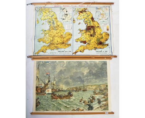
Two vintage 20th century School room / Classroom educational posters. The first being a Dutch poster showing the ' Landing Of Prince William III At Brixham ', by J.W. De Jongh and the second being a map of England from 1700 to 1911, published by Denoyer-Geppert Co, Chicago. Both with wooden mounts to top and bottom. Approx; 76cm x 109cm.


Lot 195
Voyages.- Olearius (Adam) The Voyages & Travels of the Ambassadors sent by Frederick Duke of Holstein, to the Great Duke of Muscovy, and the King of Persia... containing a Compleat History of Muscovy, Tartary, Persia...whereto are added the Travels of John Albert de Mandelslo...into the East-Indies, translated by John Davies,2 parts in 1 vol., first edition in English, engraved additional title, 7 folding or double-page maps (1 large) and 3 portraits, woodcut initials, head- and tail-pieces, large map with holing to centre partly repaired, T4 with tear to lower margins, F2, Z2 and 2F4 with small rust or burn-holes, occasional light foxing and some light soiling, contemporary calf, rebacked, upper joint cracked, corners bumped, rubbed and scuffed, [Wing O269], folio, for Thomas Dring, and John Starkey, and are to be sold at their shops, at the George in Fleet-street, neer Clifford's-Inn, and at the Mitre, between the Middle-Temple-gate and Temple-Barr, 1662.⁂ Translated from the French edition of 1659. Olearius acted as secretary on two embassies for the Duke of Holstein with the overall aim of establishing a trade route with Persia. The first was to Russia in 1633-54 in order to secure right of passage through the Tsar's lands. The second was to Persia itself in 1635.
![Second Anglo-Dutch War.- [Codrington (Robert)] His Majesties Propriety, and Dominion on the British Seas asserted. Together w](https://cdn.globalauctionplatform.com/8e7370c0-3712-4c08-a6fe-ac2500c7bd24/4e6b7cde-6ea8-4c54-a4c4-ac2600a98642/468x382.jpg)
Lot 207
Second Anglo-Dutch War.- [Codrington (Robert)] His Majesties Propriety, and Dominion on the British Seas asserted. Together with a true account of the Netherlanders insupportable insolencies, first edition, title within double-rule border, engraved portrait frontispiece of Charles II, folding engraved map of the British Isles with parts of France, the Netherlands and Norway, occasional very minor staining to head, folding map creased with neatly repaired tear from inner margin running an little into image, contemporary sheep, sympathetically rebacked, [Wing C4876A], 8vo, by T. Mabb, for Andrew Kembe, near St. Margarets-Hill in Southwark, and Edward Thomas, at the Adam and Eve in Little Brittain; and Robert Clavel, at the Staggs-Head in Ivy-Lane, 1665.⁂ Previously attributed to Robert Clavell, His Majesties Propriety was written partly as justification for the Second Anglo-Dutch War and the English actions leading up to it including the capture of New Amsterdam. Rare at auction, we can trace only a handful copies in the last 50 years.
Lot 210
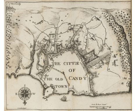
Crete.- Palmer (Roger, Earl of Castlemaine) An Account of the Present War between the Venetians and Turk; with the State of Candie: (In a Letter to the King, from Venice.), first edition, engraved portrait frontispiece of the Earl of Castlemaine by Faithorne (trimmed at head), engraved folding map of the Eastern Mediterranean, engraved folding plan of Old Candy Town (present-day Heraklion) by Wenceslaus Hollar, lacking final blank f., E4 with neat marginal repair, light damp-staining to first few ff., bookplate to pastedown, contemporary calf, gilt, neatly and sympathetically rebacked, [Blackmer 1239; Wing C1239], 12mo, by J.M. for H. Herringman, at the Anchor on the lower walk of the New-Exchange, 1666.⁂ "Charles II had asked the Earl of Castlemaine to keep him informed of events while he toured Europe, and on Castlemaine's arrival in Venice he sent the King a long letter of information on the war in Crete between the Venetians and the Turks, which was then entering its final phase. When Castlemaine returned to England he received permission to print the letter, which is a basic source of information on the 20-year battle in Crete." - Blackmer. Provenance: "Ex P. G. Libris" (bookplate).
Lot 226
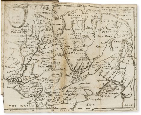
India.- Bernier (Francois) The History of the Late Revolution of the Empire of the Great Mogol: together with the Most Considerable Passages for 5 Years Following in that Empire, translated by Henry Oldenburg, 2 parts in 1 vol., first edition in English, folding engraved map at end, title within double-rule border, woodcut initials, rust-hole to E2, touching text, K5 with small hole to lower margin affecting catchword, the odd spot or patch of browning, but very good generally, later calf-backed boards, joints cracked, wear to extremities, [Wing B2043], small 8vo, sold by Moses Pitt at the White Hart in Little Brittain, Simon Miller at the Star in St. Pauls Church-Yard, and John Starkey at the Miter near Temple-Bar, 1671.⁂ Scarce, with a section on Kashmir and map at the end covering the Indian peninsula as far south as Golconda.
Lot 237
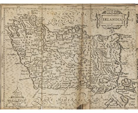
Ireland.- Present (The) State of Ireland: Together with some Remarques upon the Antient State thereof. Likewise a Description of the Chief Towns, first edition, title within double-rule border, engraved folding map, woodcut initials and head-pieces, 2 advertisement ff., lacking final 2 blank ff., closely shaved, touching title border, a few headlines and affecting some text on L6, maps with a 2 short tears at folds and chip to foot, occasional damp-staining to fore-margin, bookplate to pastedown, 19th century calf, gilt, gilt arms to upper cover, some scuffing to lower cover, [Wing P3267], 8vo, by M. D. for Chr. Wilkinson at the Black-Boy in Fleet-Street, and T. Burrell at the Golden-Ball under St. Dunstans Church, 1673.⁂ A scarce work that includes a few references to America and is principally concerned with arguing English dominion over Ireland. Provenance: David Constable (1795-1857, gilt arms to upper cover); Kinnaird (armorial bookplate).
Lot 26
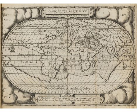
Broughton (Henry) A Concent of Scripture, second edition, engraved architectural title, engraved folding world map after the 1570 Ortelius oval map and 4 plates by William Rogers after Jodocus Hondius the Elder, woodcut initials and headpiece, title with some dampstaining and restoration to corners, dedication f. with restoration to margins, dampstainng, modern panelled calf, gilt, [STC 3851], small 4to, [?For Gabriel Simson and William White?], [?1590].⁂ Second edition of a tract first published c. 1588-90. Includes early example of English copperplate engravings.
Lot 291
Middle East.- Chardin (Sir John) The Travels...into Persia and the East-Indies..., 2 parts in 1 vol., first edition, engraved portrait by D.Loggan and additional pictorial title, engraved title-vignette, head- & tail-pieces and initials, folding engraved map and 14 plates only (of 16), most double-page and/or folding, Directions to Binder and half-title to Coronation of Solyman III at end of first part, 4G2 with portion torn away from margin and tear running into text, 4H1 with small hole and loss to 2 or 3 letters of text, a few plates closely shaved, some with tearing or fraying to margins, occasional light foxing or browning, contemporary calf, rebacked, corners worn, new endpapers, [Wing C2043], folio, for Moses Pitt, 1686.⁂ Published concurrently with the French edition. Chardin was born in Paris but emigrated to England with the persecution of the Protestants, where he became court jeweller to Charles II.
![Atlases.- Morden (Robert) [Geography Rectified: or, A Description of the World], maps only, no title or text, comprising doub](https://cdn.globalauctionplatform.com/8e7370c0-3712-4c08-a6fe-ac2500c7bd24/4515f86d-f206-44c6-b9f1-ac2600a9a6c7/468x382.jpg)
Lot 299
Atlases.- Morden (Robert) [Geography Rectified: or, A Description of the World], maps only, no title or text, comprising double-page engraved 'Catalogue of Mapps in This Booke' and 77 double-page engraved maps only (of 78, lacking map of Bermudas), all with attractive bright outline hand-colouring in contemporary hand, all mounted on stubs, some offsetting and foxing, 2 maps with repairs to margins, 1 map closely shaved at foot, just within plate margin, ink inscription to front endpaper, faint ink stamp to rear endpaper, contemporary calf, neatly rebacked, retaining much of original backstrip, 8vo, n.p., [c.1688]⁂ Bound volume of maps from Morden's Geography Rectified including a twin hemisphere map and 16 maps of the Americas, with a general map of America showing California as an island. The work was first published in 1680 with 62 maps and a second, enlarged, edition in 1688 with 78 maps. Provenance: Susanne Simond Louise (ink inscription).
Lot 338
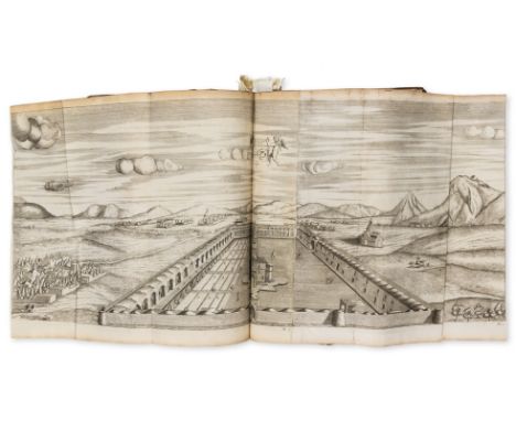
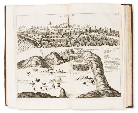
Asia.- Fryer (John) A New Account of East-India and Persia, first edition, title printed in red and black with double-rule border, half-title with engraved portrait on verso, 7 engraved maps and plates, 3 double-page, one full-page engraved map in text, with printed slip pasted below, occasional browning, a few ff. heavily, bookplate to pastedown, contemporary speckled calf, spine gilt in compartments, spine rubbed, joints splitting at head and foot, [Wing F2257], folio, R.R. for Ri. Chiswell, at the Rose and Crown in St. Paul's Church-Yard, [1698].⁂ In 1672 Fryer embarked on a 10-year tour to India, Goa, the Arab Gulf and Persia then returned to England. The work includes a detailed account of Surat and Muscat and mentions pirates in the Gulf, and the natural history of the region.Provenance: Sr. John Wentworth of North Elmes Hall (armorial bookplate).
Lot 36
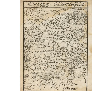
Kent.- Lambarde (William) A Perambulation of Kent: Conteining the Description, Hystorie, and Customes of That Shire, second edition, black letter, title within elaborate typographic border, woodcut initials, woodcut Heptarchy map (closely shaved at foot as often), folding woodcut map of the Beacons in Kent (a little chipped at foot), title a little darkened, occasional dampstaining and some soiling (heavier at end), but a good, well-margined copy generally, restoration to front free endpaper, ink inscriptions to endpapers, contemporary calf, upper joint restored, [STC 15176], by Edm. Bollifant, 1596.Provenance: T Craddock; Rd. Twopenny; Edwd. Twopenny (ink inscriptions).
Lot 58
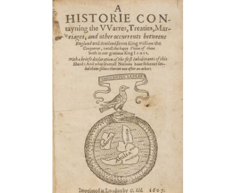
Ayscu (Warres) A Historie Contayning the Warres, Treaties, Marriages, and other occurents betweene England and Scotland, first edition, title with woodcut device depicting map of the British Isles within an uroboros border, woodcut initials and headpieces, with blank A8 but lacking blank A1, blindstamp to title, occasional light foxing or staining, ink ownership inscription to foot of P8 verso, bookplate to pastedown, 19th century half calf, extremities rubbed, [STC 1014], small 4to, by G. Eld, 1607.⁂ An abridgement of earlier histories, this work seeks to glorify King James I and defend his claim to the united crown. Provenance: Joseph Swayne (ink inscription); William Fuller Maitland (bookplate); Westminster College Library, Fulton, Missouri (blindstamp).


Lot 233
PETER JAMES; watercolour, 'Boats at Rest', signed and dated 1991 lower right, 16 x 31.5cm, framed and glazed, together with an engraved map of Derbyshire by J. Cary, 15 x 10cm, framed and glazed (2). (D)Additional InformationThis lot qualifies for Artist Resale Rights. For further information, please visit http://www.dacs.org.uk or http://artistscollectingsociety.org


Lot 376
AFTER HERMANN MOLL "Glocestershire", a later coloured black and white engraved map, published circa 1733 for "A New Description of England and Wales" with map of Kent uncoloured verso, image size 22 cm x 32 cm, together with AFTER CHRISTOPHER SAXTON "Glocestriae", a later coloured black and white engraved map by Willliam Hole, image size 29 cm x 31 cm


Lot 258
Collection of 15 antique maps of Derbyshire, mostly 18th & 19th century, to include an Ogilby road map from London to Derby, 1675 or later, and others (including Cary, Walker, Owen & Bowen, Kitchin), all framed & glazed. Together with a folded, linen-backed map of South Derbyshire, 1836 (16)

Lot 144
A Colonial Map Powder-Horn In 18th Century Style, And Fifteen Miniature CannonThe Last 19th Century And LaterThe first formed from a section of cowhorn and incised in scrimshaw work depicting the forts, townships and settlements along the coast of New England including Dorchester, Fort Alban, Fort Moor, Port Hunt, Great Egg Harbor, Bear Hole and Delawar Bay, and two ships at anchor, and with turned wooden nozzle; the last mostly of brass and of characteristic form, one on brass carriage of garrison type, the others each on a stepped wooden base (16)The first 36.5 cm., the last 3 cm. to 16.2 cm. barrels For further information on this lot please visit Bonhams.com


![[PHILIPPINES] CHRISTIE (E. B.) The Subanuns of Sindangan Bay, 4to, map frontis & photo plates, rebound in black cloth, Ma](https://cdn.globalauctionplatform.com/7e61c0c4-4f4c-488f-9e39-ac3000af2982/3f18fa97-50d0-4279-ad0b-ac3000d04a18/468x382.jpg)
![[MAP] BOWEN (E.) mapmaker / surveyor: A New Map of the County of York...shewing also by Concentric Circles the Distances...,](https://cdn.globalauctionplatform.com/7e61c0c4-4f4c-488f-9e39-ac3000af2982/e5230f70-4bb4-49df-aadc-ac3000d077bf/468x382.jpg)
![[MAPS] q. of mostly UK town and country maps Duplex Map of London "and 25 miles around", some foreign guidebooks, etc. (Q).](https://cdn.globalauctionplatform.com/7e61c0c4-4f4c-488f-9e39-ac3000af2982/e47b31f6-1954-4730-98d7-ac3000d09791/468x382.jpg)
![[BIG GAME / AFRICA] BUCHANAN (Angus) Exploration of Air. Out of the World in Nigeria, 8vo, photo plates, map, pictorial clo.,](https://cdn.globalauctionplatform.com/7e61c0c4-4f4c-488f-9e39-ac3000af2982/f5e9361c-9bda-4a1f-bf49-ac3000d104ba/468x382.jpg)
Lot 220
[BIG GAME / AFRICA] BUCHANAN (Angus) Exploration of Air. Out of the World in Nigeria, 8vo, photo plates, map, pictorial clo., L., 1921; DRAKE-BROCKMAN, Mammals of Somaliland, 8vo, 1910; SWAYNE (Major H.) Seventeen Trips through Somaliland and a Visit to Abyssinia, 8vo, plates, maps., illus., clo., L., 1903; WHITE (S.E.) The Rediscovered Country, 8vo, photo plates, L., n.d. (4).
-
109182 item(s)/page