We found 109182 price guide item(s) matching your search
There are 109182 lots that match your search criteria. Subscribe now to get instant access to the full price guide service.
Click here to subscribe- List
- Grid
-
109182 item(s)/page


Lot 102
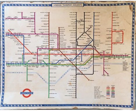
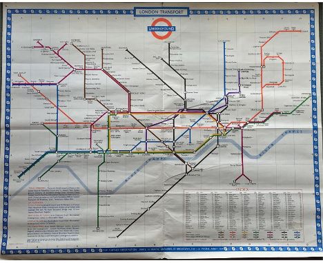
1949 London Underground quad-royal POSTER MAP designed by Harry Beck and mounted on hardboard, probably for official use. Shows the planned Northern Line extensions to Bushey Heath & Alexandra Palace and of the Bakerloo to Camberwell, none of which transpired. Scuffed edges with one or two small losses & some damp stains. The hardboard is bent in places & the backing paper on the reverse is coming away. [1] NB: this item measures 50" x 40" (101cm x 127cm).

Lot 110
London Underground linen-card POCKET MAP from the Stingemore-designed series of 1925-32. This is the last issue in 1932 with mustard cover and showing all the new lines completed with opening dates on the reverse. In very good condition and would be mint but for light vertical creasing near the r/h edge. [2]

Lot 119
c1909 Central London Railway POCKET MAP. The cover and reverse side are CLR's own, including their traditional map of their line superimposed on a street-map but the main map is the then standard London Electric Railways version which had been made available to non-Group companies as a gesture of support for a network approach. A well-used copy with wear to the cover and short fold-partings in places but still quite reasonable. [1]

Lot 128
1924 British Empire Exhibition at Wembley official fold-out PLAN & MAP designed by Kennedy North in a style similar to MacDonald Gill with an Underground map with calligraphed station names and elaborate, colourful illustrations plus a 1920s Metropolitan Railway MAP of 'Extension Lines into Metro-Land' with a map of London area lines on the reverse. Both in used condition with a little wear but good overall. [2]

Lot 131
1912 London Underground POCKET MAP "London's Guiding Star" printed by George Philip & Son Ltd and featuring the vertical UndergrounD logo. This issue marks stations with black-outlined white circles and shows the Met station as Hammersmith (Grove). The reverse shows a theatre plan, places of amusement etc. The 'Guiding Star' version of this map is quite uncommon. A little age-darkening but otherwise in very good condition. [1]


Lot 148
Pre-1914 London & North-Western Railway fold-out MAP OF THE BRITISH ISLES with inset London Tube Railways map. A high-quality linen-backed map of the national rail network (opens out to 34" x 42" - 87cm x 107cm) inside leathercloth covers with gilt lettering. Undated but first owner has written May 27/14 inside the cover and the Underground inset map shows the CLR from Shepherds Bush to Bank only (extended to Liverpool St in 1912). In very good condition. [1]
Lot 149
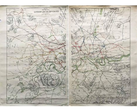
1927 Railway Clearing House 'Official Railway MAP of London & its Environs'. These highly detailed, coloured maps were produced to help the office staff of the RCH to apportion the revenues to the railway companies from the operation of services over each other's tracks. This London area poster map is produced in two sections, each measuring 28.5" x 42" (73cm x 107cm). In used condition with some short edge tears, a small edge loss and light creasing. [2 parts]
Lot 152
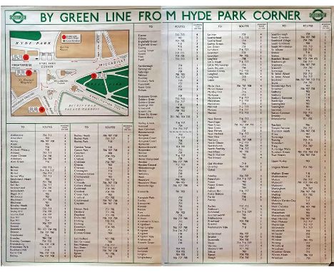
1947 London Transport POSTER 'By Green Line from Hyde Park Corner'. A pair poster (2 x double royal) issued in April 1947 for the start of the first summer of the fully re-instated coach network after WW2. Has the pre-war style 'bullseye' logo plus a map of Hyde Park Corner and an alphabetical list of towns/places served by Green Line from there. R/h poster is scuffed at the r/h edge & has a small loss at the bottom r/h corner, otherwise the pair is in good condition. [Pair]


Lot 162
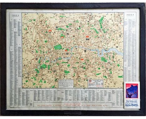
1939 London Transport POSTER MAP of Central Bus Routes with index of places served. Map is contained in an official glazed, wooden frame marked 'London Transport' (in contemporary style with over and underlining) at the lower edge. Measures 36" x 28" (92cm x 72cm) in total and is in good condition. Lot includes a copy of the May 1931 LCC Tramways MAP & TIMETABLE in good condition. [2]

Lot 170
1919 London Underground MAP OF THE ELECTRIC RAILWAYS OF LONDON 'What to See & How to See it' with print-code 209-500M-18-6-19. Has the black, open, bullseye circle on the cover and opens out in 8 panels to 13.7" x 10.9" (34 x 28cm). Some age-darkening and a bit fragile at the folds with a couple of short partings but overall a very reasonable copy. [1]

Lot 175
October 1911 London General Omnibus Company pocket MAP AND GUIDE TO OMNIBUS SERVICES. Featuring a B-type bus on the cover, this is the 8th edition of the London bus map, a series that ran from 1911 to 1993. This is a fine example, a little weak at some folds and corners but still good overall. [1]

Lot 179
c1898 London Underground MAP 'The District Railway Map of London, 6th edition'. 1st issue of this edition, shows Putney Bridge & Wimbledon section as inset, line to Bow & Southend etc dotted in red & Great Western extension to Park Royal dotted in blue. Tube lines are shown dotted in blue (under construction) except for the C&SLR between King William St & Stockwell, shown as solid line. Opens out to 43" x 26" (109cm x 66cm). In good, used condition with some wear & a few short fold-partings. [1]
Lot 188
1909 London Underground POCKET MAP 'What to See and How to See it, The Excursionists' Guide with Map'. This is the map with numbers referring to points of interest listed on the reverse. Ex-guidebook example with the usual printer's cut-out at the bottom r/h edge and folded accordingly. A trace of adhesive on the reverse edge where once attached to the guidebook but otherwise in good condition. [1]

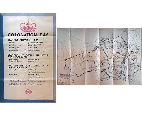
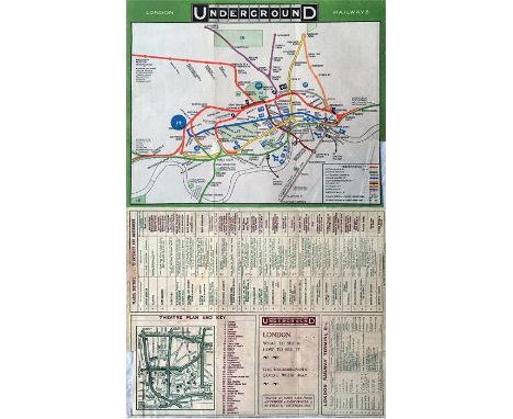
Lot 212
Original 1953 London Transport double-royal POSTER 'Coronation Day' detailing closed and restricted Underground stations plus a POSTER MAP (36" x 24" or 91cm x 60cm) 'Coronation 1953 - Royal Route - Bus Arrangements' showing areas closed to traffic etc and presumably produced for official use either by LT or the Metropolitan Police. Both have been folded and have some edge-scuffs and chafing but are in very reasonable condition. [2]

Lot 223
London Underground linen-card POCKET MAP from the Stingemore-designed series of 1925-32. This is a special edition of the c1928-9 issue with pale green cover, with cover over-print in German re North Sea crossings to England via Flushing and Hook of Holland. In very good, unmarked condition. [1]


Lot 25
1919 London Underground MAP OF THE ELECTRIC RAILWAYS OF LONDON 'What to See & How to See it' with print-code 209-500M-18-6-19. Has the black, open, bullseye circle on the cover and opens out in 8 panels to 13.7" x 10.9" (34 x 28cm). A couple of short partings at the folds but overall a good copy. [1]

Lot 257
1922 London Underground MAP OF THE ELECTRIC RAILWAYS OF LONDON 'What to See & How to Travel' with issue date 1-3-22. Designed by MacDonald Gill with calligraphed station names, the map opens out to 13.5" x 11" (34 x 28cm). In very good, unmarked condition, just a trace of adhesive on the spine and a small parting at one fold-corner. [1]

Lot 262
Early London Underground double-sided ADVERTISING CARDS comprising 'Strip Tickets' (reduced price tickets bought in strips) and 'Avoid the Weather, Shop in Comfort' with advertising for Barrett Bros store in Clapham around the map on the reverse. Neither dated but both c1910. Both in very good condition. [2]

Lot 264
1930s London & North Eastern Railway (LNER) PUBLICITY MATERIAL comprising 15pp, high-quality 1935 BOOKLET 'The Silver Jubilee - Britain's First Streamline Train' (very good condition), late-20s/early 30s 40pp BOOKLET 'On Either Side...features of interest...on East Coast Route' (good, used condition, folded), 12pp 1933 BOOKLET 'Interesting Notes for Passengers..London to Scotland' (light cover stains} & c1930s FOLD-OUT MAP of LNER & Connections (good). [4]


Lot 277
A British Railways CARRIAGE MIRROR MAP 'Southern Region Suburban Services' (glass). Undated but thought to be 1970s/early 1980s. Shows the Elmers End to Sanderstead and West Croydon to Wimbledon lines as well as the North London line to Broad Street. Lines colour-coded according to London terminal, including Holborn Viaduct. Measures 24" x 16" (61cm x 41cm). In very good, ex-carriage condition. [1] Picture is angled in order to reduce reflections.


Lot 295
1924 British Empire Exhibition at Wembley official fold-out PLAN & MAP designed by Kennedy North in a style similar to MacDonald Gill with an Underground map with calligraphed station names and elaborate, colourful illustrations. Lightly used with a little staining to covers and original owner's name on front but map-side is in good condition. [2]


Lot 297
London Underground linen-card POCKET MAPS from the Stingemore-designed series of 1925-32. These are two copies of the last issue in 1932 with mustard covers and showing all the new lines completed with opening dates on the reverse. One copy in very good, lightly-used condition, the other is worn with a small hole on the fold and the map parting from the card. [2]
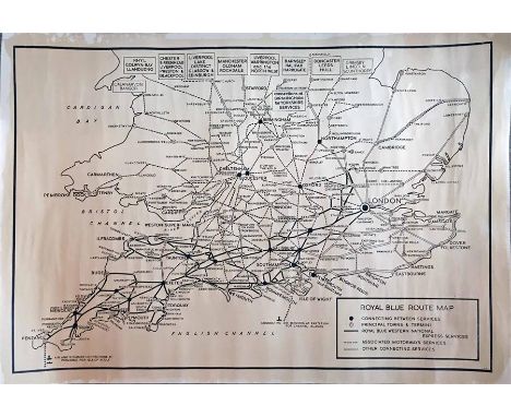
Lot 298
A Royal Blue Coaches ROUTE MAP POSTER thought to have been made for office use. Dated 1970, it shows the company's services as well as those of Associated Motorways and other connecting services as well as air and steamer connections at Penzance and Eastleigh. Very detailed with all connecting points shown. Measures 43" x 30 " (109cm x 76cm) and is in very good condition aside from a little age-darkening. [1]

Lot 324
1908 London Underground POSTCARD MAP. These cards were produced for promotional purposes and this example advertises the Liverpool Street Hotel on the reverse. Believed to be the first item of publicity which showed the word UndergrounD in a 'logo' format. Postally used and in good condition. [1]


Lot 327
1913 London Underground POCKET MAP 'What to See and How to See it'. Issued at Electric Railway House on 1-6-13. Opens out to 14" x 11" (35cm x 28cm) and shows the extensions of the Hampstead Tube to Edgware, the Central London to Ealing Bdwy and the Bakerloo to Queen's Park, all as under construction. Cover features an early example of the 'bullseye' logo. An excellent copy - crisp, clean and firm - with no significant blemishes. [1]

Lot 339
August 1911 London General Omnibus Company pocket MAP AND GUIDE TO OMNIBUS SERVICES. Featuring a B-type bus on the cover, this is the 6th edition of the London bus map, a series that ran from 1911 to 1993. This is a fine example, some weaknesses at the folds and the start of some partings but very good overall. [1]


Lot 349
c1908 Central London Railway POCKET MAP. Although the cover and reverse side are purely CLR, the map itself is the standard Underground Group map of the time and this had clearly been offered to non-members of the group (the CLR was finally absorbed into the Group in 1913) in an effort to portray a unified network. This is a used copy of this scarce map. The covers have light stains and there is wear at the folds but it is still a very reasonable example. [1]
Lot 356
1925 London Underground linen-card POCKET MAP from the Stingemore-designed series of 1925-32. This is the first edition, dated 11-5-25, and is in the smaller size of the first 5 editions. Crisp, firm and unmarked, this example is in excellent condition, one of the best we have seen of the first edition. [1]

Lot 358
1930s BUS TIMETABLE BOOKLETS comprising Brighton, Hove & District dated May 1936, Chesterfield Corporation dated September 1939 and West Riding (Tramway and Motor Omnibus Services) dated July to September 1935, complete with fold-out map. Light wear but generally in good to very good condition. [3]

Lot 366
1898 District Railway COUNTRY MAP OF THE ENVIRONS OF LONDON. A pocket map, paper contained in card covers, that folds out to 12.5" x 17" (32cm x 43cm) and covers from Hatfield in the north to Guildford in the south. This is the 3rd (and final) edition of a series which began in 1883. Lightly-used with short fold-partings and some creasing to the cover but still a good example of a very scarce map. [1]

-
109182 item(s)/page