

Mark Schuler (American, B. 1951) "First American Satellite 1958" Signed lower left. Original Mixed Media painting on Illustration Board. Provenance: Collection of James A. Helzer (1946-2008), Founder of Unicover Corporation. This artwork was originally published on the Republic of the Marshall Islands 45c First American Satellite stamp issued November 24, 1989. By the early 1950s, rockets were widely employed in studying the upper atmosphere. Scientists realized, however, that artificial satellites could perform the same duties much more efficiently. On July 29, 1955, President Eisenhower announced that the United States planned to launch "small unmanned earth-circling satellites." On October 4, 1957, the Soviet Union became the world's first nation to successfully launch an artificial satellite --Sputnik 1. On January 31, 1958, the U.S. launched Explorer 1, the first American space satellite. Explorer 1 discovered Earth was surrounded by ionized particles of energy. On March 17, 1958, the U.S. orbited Vanguard I, which demonstrated that Earth is almost imperceptibly pear-shaped with a slight bulge in the Southern Hemisphere. On October 1, 1958, the U.S. established the National Aeronautics and Space Administration (NASA) to manage the country's fledgling space program. On February 17, 1959, NASA launched Vanguard II, which was designed to provide information about Earth's cloud cover. Vanguard III followed several months later and was used to map Earth's magnetic field. The birth of the Space Age provided mankind with new insights into the mysterious universe and our place in it. Image Size: 12 x 12 in. Overall Size: 20 x 20 in. Unframed. (B12232)
We found 109182 price guide item(s) matching your search
There are 109182 lots that match your search criteria. Subscribe now to get instant access to the full price guide service.
Click here to subscribe- List
- Grid
-
109182 item(s)/page

Hodges Soileau (American, B. 1943) "Red Cloud" Signed lower right. Original Oil painting on Canvas laid on foam board. Provenance: Collection of James A. Helzer (1946-2008), Founder of Unicover Corporation. This painting was originally published on the Fleetwood First Day Cover for the U.S. 10c Red Cloud stamp issued August 15, 1987. Born in 1822 on Blue Creek in Nebraska, Red Cloud earned a reputation as a warrior, diplomat and leader. Described as a natural born gentleman, Red Cloud led an independent band in the 1860's, and was eventually accepted as leader of the Oglala Sioux -- the largest Teton Sioux tribe. Throughout this period the Oglala dominated the rich Powder River hunting grounds of Wyoming and Montana. Meanwhile, as the Civil War raged eastward, John Bozeman was sent to map a trail through Oglala territory to the Montana gold fields. Red Cloud strongly opposed the route, and, in hopes of peaceably stopping its use, he attended a council at Fort Laramie in June 1866. There he discovered a column of soldiers leaving to build three forts for protection of travelers to the gold fields. Red Cloud immediately left the council, and during the next few months gathered two thousand warriors to constantly harass the forts. On December 21, 1866, the Indians set an ambush that annihilated Captain W.J. Fetterman and his eighty men. During the following months, Red Cloud kept relentless pressure on the three forts until he succeeded in forcing their abandonment. He won both victory and peace with the treaty he signed on November 6, 1868. In his later years, Red Cloud continued to lead the Oglalas, while heading the Red Cloud Agency at Fort Robinson. On October 7, 1878, he established the Sioux Agency. Blind and ailing, Red Cloud died December 10, 1909. Image Size: 14 x 12 in. Overall Size: 18.25 x 16.25 in. Unframed. (B11201)


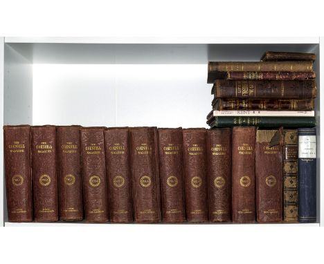
NO RESERVE Cornhill Magazine (The),11 vol., comprising first series vol.1-9, 15 & 17, plates and illustrations, some folding, occasional foxing, uniform original blind-stamped cloth, rubbed and soiled, 8vo, 1860-68 § Nevill (Ralph) Old Cottage and Domestic Architecture in South-West Surrey, illustrations and plates, folding map, occasional light spotting, original cloth, gilt, extremities rubbed, 1889; and 8 others, miscellaneous (20) ⁂ The first is an important Victorian literary journal containing the first appearnces of works by Anthony Trollope, Alfred Tennyson, Henry James, Elizabeth Gaskell, Thomas Hardy, George Eliot and Wilkie Collins.


China.- Martini (Martino) De bello Tartarico Historia; in qua quo pacto Tartari hac nostra aetate Sinicum Imperium inuaserint, engraved pictorial title, folding map of China and 8 folding plates, small worm traces / holes, mostly marginal, but just within text towards end, affecting (part of) the odd letter in those instances, occasional spotting, contemporary calf, head of spine repaired, backstrip with new gilt and double morocco labels, lower cover detached, corners little worn, rubbed, [Cordier, Sinica, 623], 12mo, Amsterdam, J. Jansson, 1655.

NO RESERVE Iraq.- Government of 'Iraq. Maps of 'Iraq with Notes for Visitors, revised and enlarged edition, frontispiece, 9 folding colour maps of roads, ancient sites etc., some frayed at edges, map of Baghdad split into two at one fold, old ink stamp and pencil Arabic inscription to front free endpaper, original cloth, rubbed, lower cover stained, spine nibbled at foot, preserved in modern rexine slip-case, 1929 § Gadd (C.J.) History and Monuments of Ur, second impression, plates, lightly browned, original cloth, slightly rubbed, 1929, folio & 8vo (2)
NO RESERVE Polar.- Whaling.- Reste (C.Bernard de, translator) Histoire des Pêches, des Découvertes et des Établissemens des Hollandois dans les Mers du Nord, 3 vol., half-titles, with 5 folding engraved maps (of 6) and 11 plates only (of 22), most folding, one map in vol.3 slightly frayed at fore-edge, some light browning and marginal staining, old ink library stamp to upper outer corner of half-title of vol.2 (torn away in vol.1 & 3), contemporary tree calf with central gilt monogram "BM" or "MB", red roan and paper labels to spines, rubbed, corners worn, some splits to joints, [Sabin 70100], 8vo, Paris, Nyon, 1801; sold not subject to return⁂ A translation of de Jong's Nieuwe beschryving der walvisvangst en haringvisscherij of 1791, including much information on the polar region but particularly whaling and fishing.

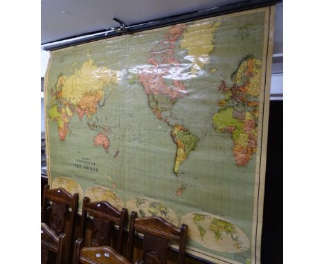
NO RESERVE World.- Guthrie (William) Guthries Atlas, engraved frontispiece and 30 maps, 1 folding, ink annotations to 30 maps, tear to final map, neatly repaired, occasional spotting, previous owner's ink signature to title, contemporary half-calf, a little rubbed, 1827 § Caumount (M. de) Cours d'Antiquités Monumentales ... Atlas, 9 plates and 1 hand-coloured map, previous owners pencil and hand-coloured sketches of map and plates to title map versos, previous owner's signatures to half-title and title, spotting, contemporary half-calf, rubbed, Paris, 1830; ob.4to (2)
Dorset.- Hutchins (John) The History and Antiquities of the County of Dorset, 2 vol., first edition, list of subscribers, large folding engraved map, 58 engraved plates and plans including the unlisted views of Dorchester and Woolcombe Hall, many folding or double-page, 10 folding pedigrees and folding letterpress leaf of first page of Domesday Book, engraved illustrations, with additional engraved portrait of the author by Collimore after Bestland tipped in at beginning of vol.1 (slightly water-stained and frayed at edges, reinforced), also with large folding aquatint of 'South East View of Shaftsbury' by Pollard & Jukes after Samuel Marsh Oram mounted on stub at beginning of vol.2 (a little soiled, frayed and trimmed at foot affecting imprint, laid down), contemporary ink signature of W.L.Bowles at head of title to vol.1 and to final leaf, a few leaves creased, some light browning but generally clean, occasional marginal soiling or water-staining, plate of Critchill House in vol.2 with tear to fold slightly affecting image, contemporary half diced russia, uncut, rubbed, some wear to corners and foot of spines, folio, W. Bowyer and J. Nicholls, 1774.


Astronomy.- Unentbehrlicher dreyfacher Leit-Stern der Reisenden, 2 parts in 1, engraved frontispiece, folding map and 7 plates, 2 with volvelles, map with short tear without loss and creases, some mostly light foxing and staining, lightly browned throughout, black straight-grain morocco, upper cover stamped 'C.E.D, 1787', metal clasps, spine repaired, rubbed, 12mo, Leipzig, Christian Friedrich Gessner, [?1724]. sold not subject to return.

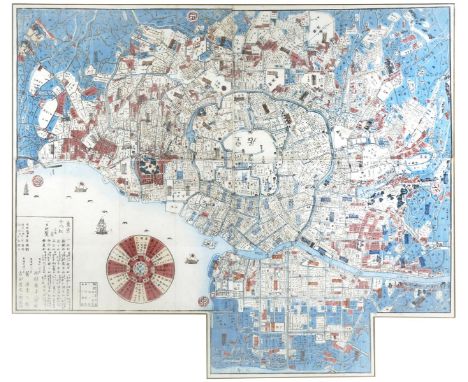
A LARGE JAPANESE PRINTED MAP OF TOKYO MEIJI PERIOD, 19TH CENTURY Orientated to the West and printed on four sheets of paper, showing the old centre of Edo with the Imperial palace and the mouth of the river Sumida, with areas and details picked out in red and blue and with a compass rose device, framed and glazed, 91cm x 64cm. The inscription in the lower left corner lists 'the eighteen most famous pine trees of Tokyo' with their locations and so this map was probably aimed at Japanese visitors sightseeing in the city.


RNSC (6) 11. Operation Neptune, D-Day, 6th June 1944 'Pre-Assault Royal Navy Bombardment. Cover design shows a map of the Navy approach and assault on the beaches. 50th Anniversary postmark 'Battle for Caen' 5 June 1994. Signed by Reginald J. Bettis RM (Marine (Signalman) 46 Commando, came ashore Juno Beach). Good Condition. All signed pieces come with a Certificate of Authenticity. We combine postage on multiple winning lots and can ship worldwide. UK postage from £3.99, EU from £5.99, Rest of World from £7.99.


Various postcards with related ephemera, etc., Famous Farmhouse Recipes Book, Quinton (AR) The England Of.... , printed postcard scenery, Within near Oxford, Betchworth near Reigate, Ludlow, various other postcards, related ephemera, Owen Bowen map of Essex, Dyson (Wil) Cartoons, after Starwood caricature, related ephemera, etc. (a quantity)

Various continental cover envelopes, some ungummed, unused etc. to include Hier 2nd Class Kolner, On Her Majesty's Service envelope, Aero Gramme, various other air letters, mid 20thC with sixpence stamp, Packet-Verkehr envelopes, various others, Great Britain map envelopes, shaped ungummed examples, many others House of Commons, Sandringham Norfolk letterhead handwritten dated 1935 to Cecil signed Veronica Forester, various Inland registered letter post envelopes, etc. (a quantity)

Stamps and philately, an album of various 1950s and later collectors stamps to include Portuguese Scientist sheets of four December 1st 1966, September 26th 1960 Europa, other Portuguese Lisbon, March 28th 1960 Congress Lisbon, December 1st 1965, various other 1953, etc. a quantity of various other loose GB related postal items, Canadian postcards, various others unused, a quantity of various collectors stamps, unused examples, other Portuguese items, black ceres proof with large margins and frame, 40c blue ceres, various envelopes, telegram envelopes, etc. Robbialac Hotel Atlantico Lisbon, a quantity of other mid 20thC and other, Examiner 1292, various other dates, Porto 1945, other handwritten envelopes with stamps for 1953, etc., other Portuguese related stamps, map, handwritten letters. (a quantity)


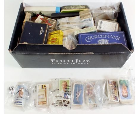
A varied and interesting collection of 18thC and other ephemera, an unusual Miss Fatima The Famous Bare Dancer advertising card with removable section, From The House of Questa ephemera, a quantity of pocket maps to include Bacons County Map of Suffolk, CWS Road Atlas Motorist and Cyclist Compendium of England and Wales, Collectors Club French Morocco The 1943-44 Tour Hassan Issues, various cigarette trade cards, etc., horse racing related various players, Ogdens, Churchman Cigarettes, In Town Tonight, Steve Donoghue Sporting Champions cigarette card, Anstie Devizes Racing cards Downland, Players Cigarette large racing card, various others, small quantity of racing ephemera, Boguslavsky Turf Cigarettes Big Events on The Turf cards, My Magazine, International 1939 Luik envelope, Aeronautics magazine, various others, other aviation ephemera, The Modern Boy magazine, Meccano magazine, Aircraft Identification, printed ephemera on The Schneider Trophy, horse racing programmes to include Newton Abbot 1963, vacant stamp pages, Kay Boots and Shoes vintage calendar 1914, Paton's Threads Give Satisfaction Scottish advertising booklet, Anderson (Tod) Come and See The Performing Rabbits pamphlets, various prints, pictures, world stamps, Peach (Jack) Machine Marks UK paperback, a Derby County Vs Manchester United football programme 22nd January 1966, notice No Delivery 10th March 1863, reproduction Marriage of Prince of Wales leaflet, Income Tax and House Duty report, Inland Revenue letter, London City and Midland Bank Ltd letter, various late plans and maps of seaside towns Scarborough, etc. reproduction and others, various printed information on coins, postmarks, etc., artist's pad, early newspapers The Derby Mercury Thursday January 21st 1808, Harrison's Derby and Nottingham Journal 25th November 1779, The Pilot 1810, The Newcastle Journal June 6th 1801, The CTC Gazette, The Cyclist Touring Club Gazette, books, various prints aeroplanes etc., quantity of others of French Surcouf and other vessels Japanese etc., 1830 returned letter, postal orders, various printed ephemera on postal order history, a quantity of other ephemera, Free Vehicle Security, stickers, bill of sale from Maple & Co 1904, House of Commons letters, a further letter dated 1845 for a James McKenzie, collectable and other postcards, a quantity of Philatelic Society ephemera, recipe cards, various postal related ephemera with some advertising, etc. (a quantity)


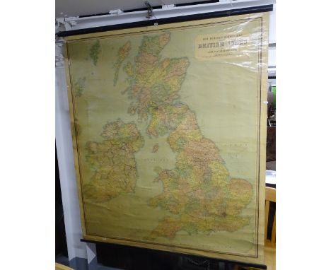
Two maps comprising 'Bowles's Reduced New Pocket Plan of the Cities of London and Westminster, with the borough of Southwark, exhibiting the buildings to the year 1793', framed, a late 19th century map of North Riding, framed, also three indentures two date mid-1840s and of Somerset interest, the other dated 1704/5 (5).


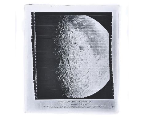
A large-format vintage gelatin silver print, medium resolution, numbered IV-173M, captioned in margins: 'NASA-LRC LUNAR ORBITER PROJECT - MISSION IV SPACECRAFT FRAME NO 173, 1 OF 1 MEDIUM RESOLUTION SITE 31B GRE05041310, KI 4131 PHOTOGRAPHED: DATE 24 MAY 1967 TIME 05:32:43:24 READOUT: MAY 29 1967 SHUTTER 02 SECOND REASSEMBLED BY: ARMY MAP SERVICE, CORPS OF ENGINEERS, U.S. ARMY, 7 JUNE, 1967' 51 x 61cm (20 x 23 ½ inches), image 43 x 49cm (17 x 19 1/3 inches) Striking image of a large portion of the lunar disc. Condition Report: Some creasing and small bends to the corners, otherwise fine. Condition Report Disclaimer
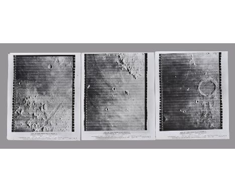
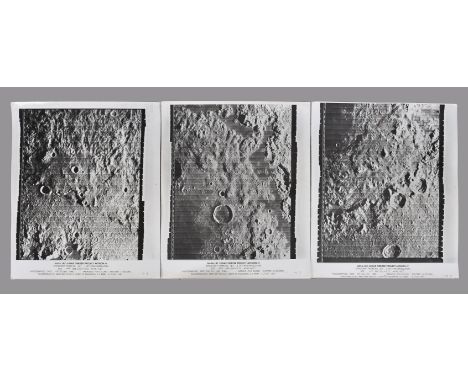
A set of three large-format vintage NASA gelatin silver prints, high resolution, frame number IV-115 H1, H2 and H3, each print captioned in margins with its respective number: 'NASA-LRC LUNAR ORBITER PROJECT - MISSION IV SPACECRAFT FRAME NO 115, 1 OF 1 HIGH RESOLUTION SITE 21D GRE04041063, KI NO 4063 PHOTOGRAPHED: DATE 19 MAY 1967 TIME 06:22:12:41 READOUT: 20 MAY 1967 SHUTTER 02 SECOND REASSEMBLED BY: ARMY MAP SERVICE, CORPS OF ENGINEERS, U.S. ARMY, 28 MAY, 1967' 51 x 61cm (20 x 23 ½ inches), image 43 x 53cm (17 x 21 inches) The high resolution images feature detailed views of portions of Mare Imbrium. Condition Report: Print H1: small loss to the top left and bottom left corners; corner bends and pin holes in top corners; small 0.5 cm tear to the bottom edge; 13 cm long strip of tape residue on the reverse along the bottom edge, not affecting the front of the print; blue marks to the top of the reverse, not affecting the front of the print. Print H2: expected wear to the corners; hand annotations in consignors hand 'PITON, SMYTH P & KERCH' on the reverse; fine Print H3: expected bends to the corners, two pin holes to the top corners, otherwise fine Condition Report Disclaimer
A set of three large-format vintage NASA gelatin silver prints, high resolution, frame number IV-187 H1, H2 and H3, each print captioned in margins with its respective number: 'NASA-LRC LUNAR ORBITER PROJECT - MISSION IV SPACECRAFT FRAME NO 187, 1 OF 1 HIGH RESOLUTION SITE 33B GRE04041270, KI NO 1427 PHOTOGRAPHED: DATE MAY 25 1967 TIME 05:26:16:88 READOUT: MAY 29 1967 SHUTTER 02 SECOND REASSEMBLED BY: ARMY MAP SERVICE, CORPS OF ENGINEERS, U.S. ARMY, 4 JUNE, 1967' 51 x 61cm (20 x 23 ½ inches), image 43 x 52cm (17 x 20 ½ inches) The high resolution images feature detailed views of Mare Orientale basin. Condition Report: Expected wear and bends to the corners. Print H2 also features a 0.5 cm deep bend to the left edge and more significant bend to the bottom left corner. Otherwise fine. Condition Report Disclaimer

Ɵ An exceptional set of seven volumes related to photography and mapping during the four Apollo missions. Includes twenty-seven folded maps featuring plots for photography from the lunar orbit: Apollo Mission 14 Lunar Photography Index Maps. Department of Defence, Aeronautical Chart and Information Center, United States Air Force for NASA. 15th June 1971. First Edition. Bound by staples into a soft cover. Contains three sheets: Sheet 1 of 3: film 16mm colour (Lunar Module descent and pre-descent, lunar module ascent and post-ascent, sextant landmark tracking); Sheet 2 of 3: film 70 mm colour (orbital science); Sheet 3 of 3: film 70 mm black and white and 5 inch black and white (landing site selection, stereo-strip, zero phase, orbital science, landing site selection). The maps unfold to the size of 145 x 35.5 cm (57 x 13 inches). Apollo Mission 15 Lunar Photography Index Maps. Department of Defence, Aeronautical Chart and Information Center, United States Air Force for NASA. 1st March 1972. First Edition. Ten folded maps bound by staples into a soft cover. The maps unfold to the size of 145 x 48 cm (57 x 19 inches) Apollo Mission 16 Lunar Photography Index Maps. Department of Defence, Aeronautical Chart and Information Center, United States Air Force for NASA. October 1972. Six folded maps bound by staples into a soft cover. First edition maps dated 28th August 1972. The maps unfold to the size of 138 x 35.5 cm (54¼ x 14 inches). Apollo Mission 17 Lunar Photography Index Maps. Department of Defence, Aeronautical Chart and Information Center, United States Air Force for NASA. November 1973. Eight folded maps bound by staples into a soft cover. First edition maps, 31st October 1973. The maps unfold to the size 145 x 48 cm (57 x 19 inches). Each map has a legend which lists a group of camera frame numbers associated with each orbital pass using different colours, either red, purple, green and black. This method enhances the clarity of the maps when images overlap. The camera types include large format panoramic large format mapping, 70mm Hasselblad and the 16mm Maurer motion picture. Apollo 17 also has coverage of the flown 35 Nikon camera. Also included are the following three volumes which provide technical information on the photography equipment, data transfers and method: Data Users Note. Apollo 15 Lunar Photography. NSSDC 72-07. National Space Science Data Center, Goddard Flight Center. December 1972. Staple bound in soft covers. Data Users Note. Apollo 16 Lunar Photography. NSSDC 73-01. National Space Science Data Center, Goddard Flight Center. May 1973. Staple bound in soft covers. Data Users Note. Apollo 17 Lunar Photography. NSSDC 74-08. National Space Science Data Center, Goddard Flight Center. December 1974. Staple bound in soft covers.
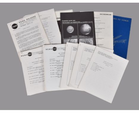
A substantial collection of material related to the Mariner and Viking space programs, comprising (among other printed material): (Mariner 2) Mariner Spacecraft, NASA News Release. Release no: 62-182. For release Wednesday PM, August 15, 1962. 38 pages, staple bound. Describes the technical specification of the spacecraft and the mission's scientific objectives. Together with America in Space. (Mariner 4) News Conference. Mariner IV Interim Science Findings. NASA News. For immediate release Monday 19 April 1965. 42 pages, staple bound. Contains the script of the press conference. (Mariner 4) Mariner IV. 2nd Birthday; Doing Fine. NASA News. Release no 66-304. For release Monday AM, November 28, 1966. 3 pages, staple bound. (Mariner 4) News Conference on initial Scientific Interpretation of Mariner IV Photography. NASA News. For immediate release 12:00 Noon EDT, July 29, 1965. 34 pages, staple bound. (Mariner 4) A set of five scripts of press conference related to Mariner IV's mission. Office of Public Educations and Information/JPL/NASA. Dates: 15, 16, 17 and 29 July 1965. (Mariner 5) Mariner Spacecraft. Planetary Trailblazers. NASA Facts. NF - 39/2-68. For Sale by the Superintendent of Documents, U.S. Government Printing Office, Washington D.C. 20402, price 20 cents. 12 pages. (Mariner 5) Return to Venus. James H. Wilson. JPL Technical Memorandum 33-393. JPL/NASA. July 1, 1968. 36 pages, soft covers. (Mariner 6 and 7) Mariner Six and Seven. NASA Mission Report MR-6. 29 November 1969. 8 pages. (Mariner 6 and 7) Mariner Mars 1969. Status Bulletin. JPL. Numbers 27-33. July/August 1969. (Mariner 6 and 7) Mariner Mars 1969. Pictures and Results from Mariner VI and VII. NASA/JPL. December 15, 1969. Large poster size publication, 91 x 95cm 37 x 37 ½ inches) when unfolded. (Mariner 9) Mariner Mars 1971. Status Bulletin. JPL/NASA, 1971-1972. Numbers 1-46 (Number 43 not included). (Mariner 9) Status of Availability of Mariner 9 (1971-051A) TV Picture Data, Supplement no 1 to NSSDC. Data Announcement Bulletin. NASA National Space Science Data Center Code 601, Goddard Space Flight Center. March 1974. 14 pages. (Mariner 9) Mars - Our New Frontier, Mariner 9 Result. JPL/NASA. Large publication in a format of large a poster, including shaded relief map of Mars. (Mariner 10) Mariner Venus/Mercury 1973. Status Bulletin. JPL/NASA, 1973/1974. , Numbers 1-36 (Numbers 26 and 29-34 not included). (Mariner 10) The Planet Mercury: Mariner 10 Mission. Journal of Geophysical Research (reprinted), Vol. 10, No. 17. June 10, 1975. Soft covers. (Mariner 10) A collection of press prints, including seven vintage gelatine silver prints featuring images of Mars as taken during the Mariner 10 mission, with copies of press captions affixed to the reverse. (Viking) Viking Project. Mission Operations Status Bulletin. NASA/Langley Research Center. 1975-1976. Numbers 1-38. (Viking) The Viking Mission to Mars. William R. Corliss. NASA SP-334. 1975. 79 pages, soft covers. (Viking) The Viking Mission to Mars. Martin Marietta Corporation. 1975. Describes the objectives of the mission and provides technical specification of the spacecraft. Other printed items are also included in the collection. Viewing recommended. Mariner program was conducted by NASA in conjunction with Jet Propulsion Laboratory, consisted of ten interplanetary probes launched between 1962 and 1973, and intended to investigate Mars, Venus and Mercury.
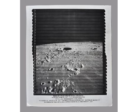
A large-format vintage NASA gelatin silver print, high resolution, frame number III-162 medium resolution, captioned in margins (containing a date error): 'NASA-LRC LUNAR ORBITER PROJECT - MISSION III SPACECRAFT FRAME NO 162, 1 OF 1 MEDIUM RESOLUTION SITE III -S-26 GRE03030490, KI NO 3049 PHOTOGRAPHED: DATE FEB 25 1967 TIME 05:02:01:35 READOUT: FEB 22 1967 SHUTTER 04 SECOND REASSEMBLED BY: ARMY MAP SERVICE, CORPS OF ENGINEERS, U.S. ARMY, MARCH 9, 1967' 51 x 61cm (20 x 23 ½ inches), image 43 x 50cm (17 x 19 ½ inches) The print features a striking image of the Kepler crater. Condition Report: Pin holes and bends to the corners - defects which can be framed out. On reverse a 21 cm long tape glue residue along the bottom edge, not affecting the front image. Small annotation in owner's hand 'KEPLER'. Otherwise fine. Condition Report Disclaimer


Commemorative Historical Polish Medals, including; 1968 restrike of the 1821 original 'Death of Napoleon on St. Helena, “Il Mourut Sur Un Rocher'; Poland / Great Britain, Lord Dudley Stuart, Bronze Memorial Medal, 1859, by J F A Bovy, bust of Stuart right, rev map of Poland in relief, 63mm. Good very fine - Lord Dudley Coutts Stuart (1803-1854), Liberal politician and advocate of Polish independence. He married a scion of the Bonaparte family;


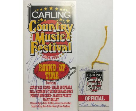
JOHNNY CASH SIGNED ITEMS. Collection of memorabilia from the 1985 'Carling Country Music Festival' in Cork, Ireland to include: programme/map signed by Johnny Cash and band members, an official pass signed by Johnny Cash, matchbooks, programme. Also a CD recording made during the Johnny Cash and band concert a The Cork Opera House, which is believed to be the only copy of the recording from the concert. All obtained by the vendor who organised and booked the festival.
-
109182 item(s)/page