We found 109182 price guide item(s) matching your search
There are 109182 lots that match your search criteria. Subscribe now to get instant access to the full price guide service.
Click here to subscribe- List
- Grid
-
109182 item(s)/page


Lot 256
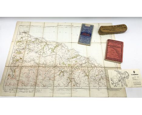
Jollie's Cumberland Guide & Directory: containing a Descriptive Tour Through the County, and a list of persons in public and private situations, in every principal place in the county : illustrated with maps and views. Also a list of the shipping, Jollie & Sons, Carlisle, 1811. (one map badly damaged)
Lot 312
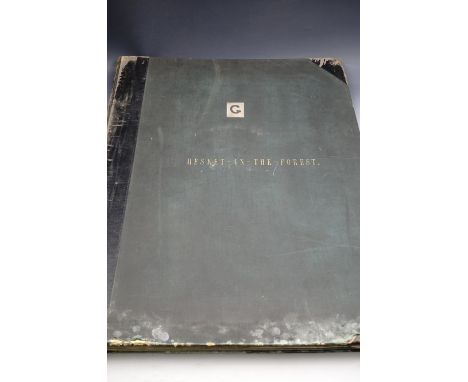
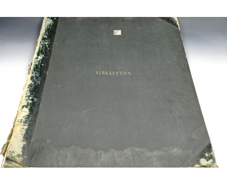
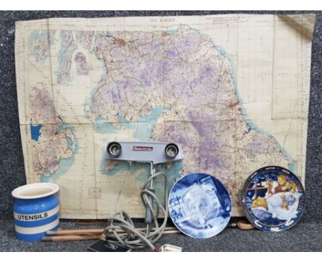
Large scale Victorian bound Ordnance Survey map, 'Ordinance Plan of the Parish of, Hesket in the Forrest, Ward of, Leath, in the County of Cumberland, Eastern Division', Surveyed by Captn. James R.E., Lithographed under the Direction of Lieut. H H Jones R.E., at the Ordinance Map Office Southampton, Published by Col. Sir H James R.E. F.R.S. M.R.I.A.&C., superintendent, July 1863, cloth bound front and back with calf spine and corners. 68 cm x 53.5 cm


Lot 434
BR(S) Suburban Services Mirror British Railways Southern Region Suburban Services Route Map mirror showing all the routes from London Bridge, Victoria, Waterloo, Charing Cross & Cannon Street, and Holborn Viaduct Stations in a coloured diagrammatic map. Measures 24in x 16in and is in excellent condition.


Lot 31
PARDOE (Miss): 'The Beauties of the Bosphorus...illustrated in a series of views of Constantinople and its environs..', London, George Virtue, 1838: with 80 steel engraved plates and map, tissue guards, later calf backed cloth covered boards, recently rebacked, occasional waterstains to corners, light toning and scattering foxing, a good copy. (1)


Lot 226
RIVER THAMES: MAP: 'The Oarsman's and Angler's Map of the River Thames', London, published by James Reynolds & Sons, 1893: new edition: folding col. litho chart in 25 sections, 8pp text loosely inserted, within original brown publisher's cloth boards, blind stamped with gilt title to upper, rubbed and frayed, contents generally sound. (1)

Lot 126
NATIVE AMERICAN INDIANS: 'Dictionary of the Chinook Jargon, or Indian Trade Language, of the North Pacific Coast...', Victorian, T N Hibben & Co, 1899: 35pp, original printed wrappers, chipped and with repairs: together with George Lloyd's 'Account of Koonawur, in the Himalaya..', London, 1841, period dark green morocco gilt, aeg, lacking the map. (2)


Lot 30
Jan and Willem Blaeu - 'Ducatus Eboracensis pars occidentalis; The West Riding of Yorke Shire' (Map of the County), 17th century engraving hand-coloured in outline on laid paper, 39.5cm x 50.5cm, within a Hogarth style frame, together with a map of Devonshire by Robert Morden.Buyer’s Premium 24.5% (including VAT @ 0%) of the hammer price. Lots purchased online via the-saleroom.com will attract an additional premium of 5% (including VAT @ 0%) of the hammer price.

Lot 32
Pieter van der Keere - 'A New Mape of Ye XVII Provinces of Low Germanie' (Map of Germany), 17th century engraving on laid paper with later hand-colouring, 9.5cm x 12.5cm, together with another 17th century map of Egypt by Robert Morden, both within gilt frames.Buyer’s Premium 24.5% (including VAT @ 0%) of the hammer price. Lots purchased online via the-saleroom.com will attract an additional premium of 5% (including VAT @ 0%) of the hammer price.

Lot 84
Jodicus Hondius - 'Tartaria' (Map of Tartary), 17th century engraving with later colour, 33.5cm x 49cm, within a metal frame.Buyer’s Premium 24.5% (including VAT @ 0%) of the hammer price. Lots purchased online via the-saleroom.com will attract an additional premium of 5% (including VAT @ 0%) of the hammer price.

Lot 89
J & H Hondius - 'La Principauté D'Orange (Map of the Principality), 17th century engraving with later colour, 39cm x 50.5cm, within an ebonized frame, together with another map 'Comitatus Bellovacum Vernaculè Beauvais'.Buyer’s Premium 24.5% (including VAT @ 0%) of the hammer price. Lots purchased online via the-saleroom.com will attract an additional premium of 5% (including VAT @ 0%) of the hammer price.

Lot 88
Abraham Ortelius - Palestinae Sive Totius Terrae Promissionis Nova Descriptio Auctore Tilemanno Stella Sigenens', (Map of Palestine), engraving with later colour, 34.5cm x 46cm, within a gilt metal frame, together with another map by Jan Bleau, 'AEthiopia Inferior, vel Exterior'.Buyer’s Premium 24.5% (including VAT @ 0%) of the hammer price. Lots purchased online via the-saleroom.com will attract an additional premium of 5% (including VAT @ 0%) of the hammer price.

Lot 33
Robert Morden - 'Staffordshire' (Map of the County), late 17th/early 18th century engraving hand-coloured in outline on laid paper, 43cm x 37.5cm, within a Hogarth style frame.Buyer’s Premium 24.5% (including VAT @ 0%) of the hammer price. Lots purchased online via the-saleroom.com will attract an additional premium of 5% (including VAT @ 0%) of the hammer price.

Lot 81
Jodicus Hondius, John Speede and John Norden - 'Sussex' (Map of the County), 17th century engraving with later colour, 'sold...by I.S. and George Humble', 40cm x 50cm, double glazed within a Hogarth style frame.Buyer’s Premium 24.5% (including VAT @ 0%) of the hammer price. Lots purchased online via the-saleroom.com will attract an additional premium of 5% (including VAT @ 0%) of the hammer price.

Lot 31
Pieter Van den Keere and John Speed - 'Southampton' (Map of the County of Hampshire), 17th century engraving with later hand-colouring in outline on laid paper, 9cm x 13cm, within a gilt frame.Buyer’s Premium 24.5% (including VAT @ 0%) of the hammer price. Lots purchased online via the-saleroom.com will attract an additional premium of 5% (including VAT @ 0%) of the hammer price.

Lot 74
C.R. Conder & H.H. Kitchener - 'Map of Western Palestine from Surveys conducted for the Committee of The Palestine Exploration Fund', engraved folding map in twenty-four sections and backed onto linen in six sheets, overall 150.5cm x 86cm, within a slipcase.This lot is subject to a Buyer’s Premium of 24.5% (including VAT @ 0%) of the hammer price. Purchased online via the-saleroom.com, this lot will attract an additional premium of 5% (including VAT @ 0%) of the hammer price.

Lot 29
John Norden and John Speed - 'Sussex Described and Divided' (Map of the County), engraving on laid paper, published circa 1610-1612, 40cm x 52.5cm, within a Hogarth style frame.Buyer’s Premium 24.5% (including VAT @ 0%) of the hammer price. Lots purchased online via the-saleroom.com will attract an additional premium of 5% (including VAT @ 0%) of the hammer price.

Lot 85
Abraham Ortelius - 'Romaniae, quae olim Thracia dicta' (Map of Romania), engraving published 1584 with later colour, 36cm x 50cm, within a metal frame.Buyer’s Premium 24.5% (including VAT @ 0%) of the hammer price. Lots purchased online via the-saleroom.com will attract an additional premium of 5% (including VAT @ 0%) of the hammer price.

Lot 82
C & J Greenwood - 'Map of the County of Sussex', engraving with later colour, published 1829, 58cm x 69.5cm, together with a 19th century aquatint, 'The Grand Review'.Buyer’s Premium 24.5% (including VAT @ 0%) of the hammer price. Lots purchased online via the-saleroom.com will attract an additional premium of 5% (including VAT @ 0%) of the hammer price.

Lot 237
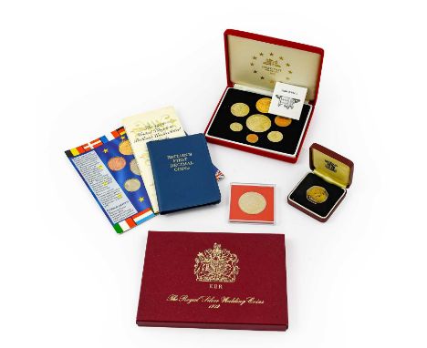
United Kingdom Piedfort Proof Ecu Set 1992, a 7-coin set of trial patterns, designed by Raphael Maklouf, for a proposed EU coinage, each with a common obverse of Neptune & Europa alongside a globe with a map of Europe & the EC’s 12 star symbol & with reverses depicting various aspects of the UK; the set comprises 10 ecu St George & Dragon (gold-plated nickel-silver), 5 ecu ‘The Three Graces’, 2 ecu Britannia with shield & trident, 1 ecu helmeted bust of Britannia, ½ ecu Lion Passant, ¼ ecu Houses of Parliament & 1/10 ecu The Mayflower, with certificate of authenticity, in fitted case of issue FDC; a similar set of 7 ecu coins, card-mounted, non-proof UNC & a 5 ecu in a plastic case, together with ‘The Royal Silver Wedding Coins’ 1972, a set of 6 sterling silver commemorative medalets with obverses depicting conjoined busts of the Queen & Prince Philip, & busts of Prince Charles, Princess Anne, Prince Andrew, Prince Edward & a Royal Corgi & all with rev. Royal Shield of Arms & Supporters; struck by the Franklin Mint Surrey, no certificate, in case of issue, some light peripheral toning o/wise FDC; lot also includes a set of 2 x £2 coins 1989 ’Tercentenary of the Bill of Rights’ & ‘Claim of Right’ in Royal Mint presentation pack BU, proof 50p 1973 & Britain’s First Decimal Coins
Lot 56
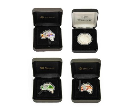
Australia, 5 x 1oz Silver Coins comprising: 3 x 1 dollar coins from the Map-Shaped Series, all struck in the shape of Australia, each 1oz .999 silver, obverses with Rank-Broadley portrait of the Queen & each with a different colourised reverse depicting an iconic Australian mammal: 1) 2013, a platypus against a background of a tropical waterfall, 2) 2013, a kangaroo against a sunset scene at Picnic Rocks, Tasmania & 3) 2014, a koala bear carrying its young against a background of bush scenery; each with a maximum mintage of 6000, together with a 1oz silver proof square 1 dollar coin from the Australian Seasons series, obv. Rank-Broadley portrait of the Queen, colourised reverse depicting an Australian possum against the background of an autumn bush sunset, maximum mintage of 5000; all struck by the Perth Mint, in cases of issue with certificates of authenticity, all BU & a 1oz frosted relief silver proof 'Kangaroo' dollar 2008, obv. Rank-Broadley portrait of the Queen, rev. a kangaroo holding a rugby ball, designed by Reg Mombassa, with certificate of authenticity, in Royal Australian Mint case of issue FDC

Lot 67
Soviet Union, 4 x Silver Proof Sets, struck to commemorate the XXII Olympiad Moscow 1980; each set comprises 3 coins: 10 roubles 33g, .900 silver & 2 x 5 roubles each 16.7g, .900 silver; 3 sets have reverses depicting views of Moscow (10 roubles), Leningrad & Tallinn (5 roubles) & one set depicting a map of Russia (10 roubles) & views of Minsk & Kiev (5 roubles), all with certificates of authenticity, individually encapsulated in cases of issue FDC, together with 4 x BU sets 1976 each 9 coins: 1, 2, 3, 4, 5, 15, 20 & 50 kopecks & 1 rouble, in cases of issue BU, 8 x cupro-nickel roubles: 1977(x7) commemorating the 60th Anniversary of the Bolshevik Revolution & 1975 ‘30th Anniversary –Victory in WW11’ all UNC, 3 x sets, each 5 coins 10, 15, 20 & 50 kopecks & rouble commemorating the 50th Anniversary of the Bolshevik Revolution & 5 x uncirculated sets: 1962 7 coins 1, 2, 3, 5, 10, 15 & 20 kopecks, 1964 4 coins 1, 2 & 50 kopecks & 1 rouble, 1965 9 coins 1 kopeck to 1 rouble & 1967(x2) 9 coins 1, 2, 3, 5, 10, 15, 20 & 50 kopecks & 1 rouble, all UNC

Lot 272
A fine Second War 1943 ‘Tunisia Campaign’ M.M. group of six awarded to Regimental Sergeant Major F. G. Findlay, Royal Army Service Corps, attached No. 6 Commando, who was decorated for his actions at the assault on Djebel Azag, 6 January 1943 Military Medal, G.VI.R. (T/5041667 W.O. Cl.3. F. G. Findley. R.A.S.C.); 1939-45 Star; Africa Star; France and Germany Star; Defence and War Medals 1939-45, good very fine (6) £3,000-£3,600 --- M.M. London Gazette 23 September 1943: ‘In recognition of gallant and distinguished services in North Africa’. The original recommendation states: ‘During the withdrawal from Djebel Azag on 6 January 1943, T.S.M. Findley repeatedly showed complete disregard for his own safety by covering his section by advancing under fire and throwing grenades. I consider that T.S.M. Findley’s actions were responsible for numerous men reaching safety. Throughout the action he showed a most excellent example to his men. He is over 40 years of age and put up a remarkable performance.’ Frederick George Findley was born in Attleborough, Warwickshire, on 24 August 1902 and attested for the North Staffordshire Regiment at Lichfield in May 1921, seeing service in Gibraltar, Turkey and India before transferring to the Army Reserve in 1928. During the Second World War, Findley served in the Royal Army Service Corps attached to 6 Commando and was decorated for his actions at Djebel Azag where an attempt was made by the British 36th Brigade Group to capture the feature known to the British as Green Hill, on 5 to 7 January 1943. Commanding the Sedjanane to Mateur road in Northern Tunisia, Green Hill was held by men from Fallschirmjäger Regiment Barenthin (German Parachute Infantry) and Witzig’s Parachute Engineers who had fortified the hill with concrete machine gun emplacements, barbed wire and mines. In his report on the ‘Attack on Djebel Azag’, Captain J. A. D. Mayne, Som. L.I., describes how ‘Mand Force’ from No. 6 Commando, comprising Force HQ, No. 1 Troop (complete), 1 Section from No. 2 Troop and one partial section from No. 5 Troop (commanded by Findley) were tasked with the following objectives: i) To capture and hold “Djebel Azag.” ii) To assist, by supporting fire, the attack on “Greenhill” and “Si Ayed”. iii) To establish an Observation Post for a Forward Observation Officer to cover targets on and behind ‘Greenhill” area. Hilary St. George Saunders’ narrative of this action in the Green Beret describes the struggle between No. 6 Commando and the elite German paratroops dug in on the hill: ‘On the 5th January they took part in yet another attack on Green Hill, carried out by the 36th Brigade. Headquarters with one and a half Troops occupied Point 277 to the north-west, the object being to protect the Brigade’s left flank and to harass the enemy’s rear; while a detachment made up of two Troops under Captain Mayne seized Djebel Azag, a height which commanded the main position. To do this they made a ten mile approach march over sodden country, the men carrying heavy loads of ammunition and food for forty-eight hours. They reached their positions soon after dawn and then dug in on the summit as deeply as the rocky ground would allow. Soon after midday the enemy made two attempts to attack them, but were beaten off at long range by accurate and well-sustained small arms fire. The Germans then resorted to mortars, in the handling of which they were exceptionally proficient, and the Commando began to suffer casualties but held on. During the afternoon Mayne observed that the enemy were forming up to deliver a counter-stroke against the brigade then engaged upon the main assault of Green Hill. His messages brought artillery fire on them and the attack did not develop. At dusk his small force, which had not been reinforced, was concentrated on the summit of the hill. At dawn Mayne’s position soon became serious, for as Lieutenant Cowper and his section were moving to their daylight positions, they were attacked at close range by Germans who had crawled up during the night. Cowper was soon engaging about two companies of the enemy strongly supported by mortars which fired a very accurate barrage. The remainder of the force was now under equally severe pressure and almost completely surrounded. Captain Davies was ordered by Mayne to withdraw headquarters and then cover a general retreat of the force, a manoeuvre which he ‘carried out extremely well.’ That evening they were all back in the tunnel near Sedjenane, the men very tired but cheerful, ‘having done magnificently.’ With a loss of thirty-five of their number they had held a key position for forty eight hours against ‘first-class troops who had been put in as stiffening.’ Though the attack on Green Hill had failed, the small action fought by Mand Force, as Mayne’s detachment was called, provides a good example of what men can accomplish who have passed through Commando training. They had been isolated for two days, in a most exposed position, and subject to galling mortar fire; but they had occupied the attention of four or five times their number who might very well have been employed elsewhere.’ Findley was a parachutist, who during his para course, landed in the top of another soldier’s parachute during a training decent which caused an injury to Findley’s back (a copy of his course report is included with the papers). Post-War he was a member of the Commando Association whose records state that his last rank attained was Regimental Sergeant Major and that he also served in No. 12 Commando. He died in 1960 in Hessingford, Cornwall. Sold with the recipient’s Soldiers’ Service and Pay Book inside which is a hand traced map of Floro, Norway with important sites and German positions marked. This map is suggestive of Findley’s participation in Operation Kitbag, a raid by British Commandos of No. 6 Commando and No. 12 Commando on the town of Floro in Norway during the Second World War - ‘Kitbag’ embarked from Scapa Flow on H.M.S. Prince Charles on 9 December 1941 but after navigational difficulties the raid was eventually called off; the recipient’s Old Comrades Association of the Special Service Brigade membership booklet, signed by the recipient and dated 9 July 1943; Pay Form No. 48 for the recipient’s Military Medal Gratuity of £20; the recipient’s Service and Casualty Form (Part I) dated 9 October 1928.


Lot 286
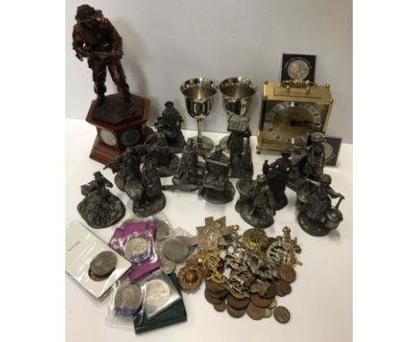
A collection of twelve Franklin Mint Cries of Old London figures by Peter Jackson circa 1977 together with certificates of authenticity together with a box containing Staiger quartz mantel clock, two plated goblets, study of World War II soldier on plinth base set with coins together with various cap badges, Royal commemorative and other crowns and British copper and white metal coinage and a framed and glazed map of Leicestershire after Robert Morden and a framed and glazed map of England and Wales after Christopher Saxton

Lot 205
After Thomas Moule. Framed map of Leicestershire, with engraved panels of Belvoir castle, Wolverscroft Abbey and Donnington Castle, in modern frame with Richard Nicholson of Chester Antique Map certificate to back, guaranteeing it to be at least 150 years old, 26cm x 18.5cm, framed and glazed.
-
109182 item(s)/page