We found 109182 price guide item(s) matching your search
There are 109182 lots that match your search criteria. Subscribe now to get instant access to the full price guide service.
Click here to subscribe- List
- Grid
-
109182 item(s)/page


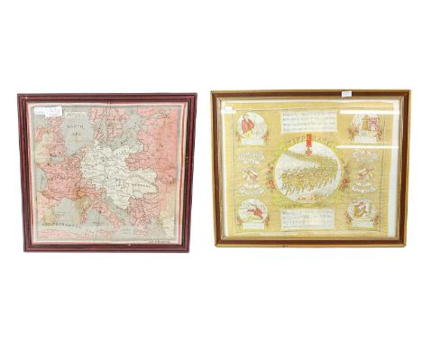
Lot 103
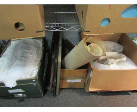
A Quantity of Militaria, including a framed First World War linen tea towel printed with the musical score of It's a Long Way to Tipperary", regimental embroidered and printed handkerchiefs, silk panels, two Union Jacks, a leather map case, three pieces of First World War brass trench art, two 1942 20mm shells converted to cigarette lighters, a milk can, a portable stove, a gas mask, a folder of printed Victory messages to evacuees and those who cared for them
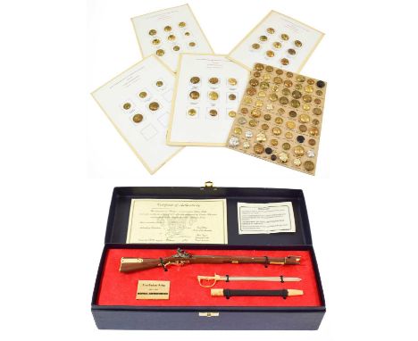
Lot 136
A Small Quantity of Militaria, comprising twenty seven officer's and five other ranks buttons to the East Yorkshire (Duke of York's Own) Regiment from 1883-1957, loosely mounted on four display cards, sixty four various other buttons loosely mounted on a display card, a silk escape map of France and Germany, and a boxed limited edition replica of "Sharpe's" Baker rifle and bayonet with Royal Armouries certificate no.551/2500
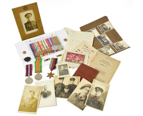
Lot 35
A Second World War Group of Five Medals, awarded to Temporary Major Ian Gray McKnight, R.E.M.E., comprising 1939-45 Star, Africa Star with 1ST ARMY clasp, Italy Star, Defence and War Medals, with MID oak leaf and War Office letter stating it will be published in the London Gazette 11.11.43, together with Medal slip, a Map of the Mediterranean with hand drawn cartoons and inscribed My Journey in the Med., also a theatre programme and ephemera including a hand written lecture on Discipline; a Second World War Trio, awarded to DVR. T/39737 A J Tompsett R.A.S.C., comprising 1939-45 Star, Defence and War Medals, with Soldier's Service and Pay Book, Release Book and economy plastic cap badge (af), together with photographs and ephemera (qty)


Lot 1419
A pair of mirrored frames a/f together with a framed photographic portrait of three gentlemen, an embroidered picture of two parrots, tapestry of a bouquet of flowers, painting on silk of flowers, print entitled English Landscape depicting an umbrella, rolled map of Norwich and two prints (10)


Lot 3264
Great Western Railway Rules and Regulations to be observed by all persons in the service of the company, 1877, South Wales Railway, General Instructions to Superintendents, Clerks, Guards, Policemen, Porters &c. 1851, T.V.R, District Plan 1890-1, Taff Vale Railway Session 1911, District Map, together with a collection of books on the subject of Railways


Lot 3232
SAMUEL RUDDER. A New History Of Gloucestershire. dated Dec 1st 1778, two double page engravings, one fold out and several other further engravings, 855 pages together with Appendix and Index, Folio. Finely bound, large fold out map of Gloucestershire to front, includes a History of the City of Gloucester, one further fold out plate to the text, with several illustrations.This is possibly one of the very early editions, which is believed were sold with plates missing as they were not ready.


Lot 295
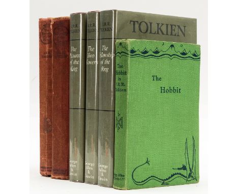
Tolkien (J.R.R.) The Lord of the Rings, 3 vol., comprising: The Fellowship of the Ring, The Two Towers and The Return of the King, second impressions,half-titles, folding map at end of each vol., first vol. with ink ownership signature to front free endpaper, original cloth, spines a little faded, slight shelf-lean, 8vo, 1954-55.

Lot 265
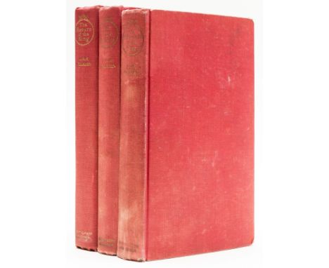
NO RESERVE Sackville-West (Vita) The Dark Island, first edition, map pastedown, original cloth, some minor bumping, else fine, dust-jacket, spine ends and corners a little chipped with neat tape repair to head of spine and upper corner verso, chip to head of upper panel, light surface soiling, an excellent example, [Cross & Ravenscroft-Hulme A30a; Woolmer 351], 8vo, Hogarth Press, 1934.
Lot 296
Tolkien (J.R.R.) The Return of the King, first edition, folding map, small library stamp to title and front endpaper, original cloth, slightly soiled, spine toned and a little worn, 1955; The Fellowship of the Ring, fifth impression, upper hinge weak, original cloth, slightly soiled, spine head and extremities rubbed, 1956; The Hobbit, third impression, colour frontispiece, ink ownership inscription to front endpaper, 1942; The Lord of the Rings, 3 vol., 3 folding maps, bookplates to front pastedowns, original cloth, dust-jackets, 1971, 8vo (6) ⁂ Return of the King with signature mark '4' and text block sagging.


![[CHILDRENS] Milne, A.A. Now We Are Six, second edition, Methuen, London, 1927, maroon cloth gilt, top edges gilt, pink picto](https://cdn.globalauctionplatform.com/40614dcd-9cf3-4a31-839d-ade900d4b512/1fc2db33-ca2e-4312-8d0c-adec01096135/468x382.jpg)
Lot 499
[CHILDRENS] Milne, A.A. Now We Are Six, second edition, Methuen, London, 1927, maroon cloth gilt, top edges gilt, pink pictorial endpapers, illustrations by Ernest Shepard, octavo; with The House at Pooh Corner, second edition, Methuen, 1928, pink cloth gilt, top edges gilt, pink pictorial silhouette endpapers, illustrations by Ernest Shepard, octavo; Winnie the Pooh, eighth edition, Methuen, 1929, dark green cloth gilt, top edges gilt, green map endpapers, illustrations by Ernest Shepard, octavo; and When We Were Very Young, sixteenth edition, Methuen, 1927, blue cloth gilt, top edges gilt, yellow pictorial endpapers, illustrations by Ernest Shepard, octavo, (4). Condition Report : All with an ink gift or ownership inscription; The House with a slightly faded spine and dulled gilt blocking. Condition reports are offered as a guide only and we highly recommend inspecting (where possible) any lot to satisfy yourself as to its condition.
![[TRAVEL] Cherry-Garrard, Apsley. The Worst Journey in the World, Antarctic 1910-1913, first edition, volume two (only), Cons](https://cdn.globalauctionplatform.com/40614dcd-9cf3-4a31-839d-ade900d4b512/cbc1d458-2a89-4a6b-9195-adec01096fbe/468x382.jpg)
Lot 515
[TRAVEL] Cherry-Garrard, Apsley. The Worst Journey in the World, Antarctic 1910-1913, first edition, volume two (only), Constable, London, 1922, original cloth-backed boards, thirty-two plate illustrations (including frontispiece, as called for), some folding, map, octavo; together with Franklin, Capt. John. Narrative of a Journey to the Shores of the Polar Sea, in the Years 1819-20-21-22, third edition, volume one (only), Murray, London, 1824, full diced black leather gilt, folding map frontispiece, folding chart, octavo, (2). Condition Report : Cherry-Garrard: Covers lightly soiled; spine with horizontal tear towards foot; Franklin: scuffed; spine head torn; lacking title label. Condition reports are offered as a guide only and we highly recommend inspecting (where possible) any lot to satisfy yourself as to its condition.
![[MAP]. KENT Blome, Richard (English, 1635-1705), 'A Mapp of Kent with its Laths and Hundreds', engraved map, hand-coloured i](https://cdn.globalauctionplatform.com/40614dcd-9cf3-4a31-839d-ade900d4b512/771d3347-05ab-4758-8dbf-adec01198b7f/468x382.jpg)
Lot 525
[MAP]. KENT Blome, Richard (English, 1635-1705), 'A Mapp of Kent with its Laths and Hundreds', engraved map, hand-coloured in outline, 27.5cm x 33cm, framed and glazed; together with two further maps of Somerset and Devon interest, each framed and glazed, (3). Condition Report : Blome: Generally good condition; no obvious holes, browning, staining, tears or repairs; fresh colours. Condition reports are offered as a guide only and we highly recommend inspecting (where possible) any lot to satisfy yourself as to its condition.
![[MAP]. SUSSEX Morden, Robert (English, c.1650-1703), 'Sussex', engraved county map, hand-coloured in outline, sold by 'Abel](https://cdn.globalauctionplatform.com/40614dcd-9cf3-4a31-839d-ade900d4b512/3c270715-6917-471c-a016-adeb011c939d/468x382.jpg)
Lot 527
[MAP]. SUSSEX Morden, Robert (English, c.1650-1703), 'Sussex', engraved county map, hand-coloured in outline, sold by 'Abel Swale Awnsham & John Churchill', 37cm x 44cm, framed and glazed. Condition Report : Generally good condition; minor staining to right upper margin; no obvious tears or repairs; fresh colours. Condition reports are offered as a guide only and we highly recommend inspecting (where possible) any lot to satisfy yourself as to its condition.
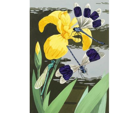
Lot 175
YUNGE-BATEMAN (JOHN) - ORIGINAL ARTWORKThree large illustrations of insects (Ruby Tail Wasp; Icheumon wasp; ?purple winged damselflies on a yellow lily), pen, watercolour and gouache on artist's pasteboard, 2 with the artist's name on verso (one with his address of 'The Long House, Angley Park, Cranbrook, Kent'), all with stamp of the 'B.L. Kearley Ltd.' agency, damselfly 390 x 275mm., others 380 x 260mm., undated; [BEES] 'What Insects Do', a complete manuscript maquette of a picture book on bees, attributable to Yunge-Bateman, 46 pages (including pictorial title, double-page map 'Where to look for...[17 types of bees and wasps]', endpapers, etc.), each with illustrations of bees or wasps, 10 in ink with watercolour and gouache, the remainder in pencil, original cloth, 4to (250 x 170mm.), [?1950s/early 60s] (4)Footnotes:Yunge-Bateman (1897-1971) is perhaps best known for the artwork he provided for several Golden Cockerel Press publications (including the Rubaiyat of Omar Khayyam), but from the late 1940s onwards illustrated many children's natural history books, including two devoted to the subject of the bee, as in this mock-up for a book seemingly never to come to press.For further information on this lot please visit Bonhams.com
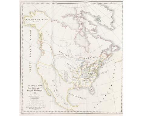
Lot 66
TOCQUEVILLE (ALEXIS DE)Democracy in America, 2 vol., FIRST EDITION IN ENGLISH, translated by Henry Reeve, half-titles, one folding engraved 'Statistical Map of the Continent of North America' (short tear at innter margin), without the 2pp. of advertisements, nineteenth century half calf over marbled boards, marbled edges, rebacked preserving original gilt-tooled spines (small repairs at extremities), later red and green gilt morocco spine labels [Howes T278; Sabin 96062], 8vo, Saunders and Otley, 1835Footnotes:First edition in English of 'One of the most important texts in political literature' (PMM 358).This lot is subject to the following lot symbols: •• Zero rated for VAT, no VAT will be added to the Hammer Price or the Buyer's Premium.For further information on this lot please visit Bonhams.com

Lot 312
WADSWORTH (EDWARD)WINDELER (BERNARD) Sailing-ships and Barges of the Western Mediterranean and Adriatic Seas, number 111 of 450 copies, copper-engraved additional title, 17 plates, map and several vignettes by Edward Wadsworth, many hand-coloured, publisher's cloth, slipcase (split at one edge), 1928--SITWELL (SACHEVERELL) A Book of Towers and Other Buildings of Southern Europe, ONE OF 12 COPIES WITH AN ADDITIONAL 3 PLATES, SIGNED ON THE COLOPHON BY THE AUTHOR AND ARTIST, from an overall edition of 350 copies, etched pictorial title and plates by Richard Wyndham, original vellum, gilt-blocked on upper cover, rebacked and recornered by Lester Capon, modern solander box, 1928; idem, number 220 of 350 copies, original half vellum over boards, 1928--DEFOE (DANIEL) The Life and Strange Surprizing Adventures of Robinson Crusoe, number 222 of 535 copies, colour pochoir illustrations by E. McKnight Kauffer, publisher's cloth, some fading to spine, 1929, 4to, Frederick Etchells & Hugh Macdonald (4)This lot is subject to the following lot symbols: •• Zero rated for VAT, no VAT will be added to the Hammer Price or the Buyer's Premium.For further information on this lot please visit Bonhams.com

Lot 33
PARISTURGOT (MICHEL ETIENNE) AND LOUIS BRETEZ. Plan de Paris commencé l'année 1734, folding double-page index map, and 20 map sheets by Claude Lucas after Louis Bretez, plates 18/19 with large cartouche are joined and folded, plates 13 and 18 quite heavily toned, occasional light spotting, contemporary calf gilt, sides with decorative roll-tool border enclosing the Arms of Paris, and fleur-de-lis corner-pieces, spine tooled in ten compartments within raised bands, gilt dentelles, g.e., worn, lower joint splitting, some loss to spine ends [Cohen-de Ricci 807], folio (555 x 430mm.), Paris, Levé et dessiné par Louis Bretez, gravé par Claude Lucas, 1739Footnotes:A magnificent detailed bird's-eye view of the whole of Paris, prepared between 1734 and 1739. If pasted together the map would have a complete decorative border with a vignette containing a description at the foot of the map.This lot is subject to the following lot symbols: •• Zero rated for VAT, no VAT will be added to the Hammer Price or the Buyer's Premium.For further information on this lot please visit Bonhams.com

Lot 24
COMIC MAPROSE (FREDERICK W.) John Bull and His Friends. A Serio-Comic Map of Europe, chromolithographed pictorial map, inset map of Europe, splitting at a few folds, old tape repairs on verso (resulting in some discolouring on recto), one ragged tear in lower blank area, folding into original printed wrappers, sheet size 532 x 725, G.W. Bacon, 1900Footnotes:A pictorial map depicing the Russian Empire as a vast octopus (with the face of Nicholas II) reaching across the continent and beyond - 'China feels the power of her suckers, and two of her tentacles are invidiously creeping towards Persia and Afghanistan'.This lot is subject to the following lot symbols: •• Zero rated for VAT, no VAT will be added to the Hammer Price or the Buyer's Premium.For further information on this lot please visit Bonhams.com

Lot 32
PALESTINE - BRITISH MANDATE AND INSURGENCYArchive relating to Jewish and Arab resistance to British Mandatory Rule in Palestine, c.1938-1946, including a rare poster, annotated map and documentary photographs, compiled by a member of the British Police or Military, comprising:[JEWISH TERRORIST ACTIVITIES]. 'Palestine North Sheet... Gridded with Palestine Transverse Mercator Military Grid', large colour-printed map of Palestine, printed 'Restricted', overlayed with 17 typed labels noting 'Terrorist activities and illegal immigration between October 1945 and March 1946', annotated in red ink with thirteen areas of conflict (from Nahiriya and Haifa in the north, to Aqir, Qastina and Jerusalem in the south) identified with red circles, fold folds, 855 x 620mm., [c.1946]SCOTT (ROBERT, Acting Chief Secretary) Proclamation by the Officer Administrating the Government. For the public good and avoidance of unnecessary suffering, of all people in Palestine should carefully note the following solemn WARNING [against unlawful possession of 'firearms, bombs, grenades... the possession of such articles is punishable with imprisonment for LIFE... or using them is punishable with DEATH...', incitements to violence, armed resistance, etc.], LARGE POSTER, royal coat-of-arms top centre, text in three columns printed in Hebrew, English and Arabic, old fold creases, 635 x 704mm., Jerusalem, 15 November 1945[IRGUN - BROADSIDE]. 'Warning! 1. The Government of oppression should WITHOUT ANY DELAY evacuate children, women, civilian persons... throughout the country. 2. The civilian population, Hebrews, Arabs and others are asked... to abstain... from visiting or nearing Government offices... YOU HAVE BEEN WARNED!', broadside on paper, headed with emblem (hand-held rifle over map of 'Israel'), text in Hebrew, English, and Arabic, 300 x 130mm., [15 May 1945][PHOTOGRAPHY - ARAB AND JEWISH UNREST AND BRITISH MILITARY]. A collection of 48 photographs including views of street unrest ?in Haifa (3), body searches (3), derailed train, dead insurgents (7), 'a public execution, Jerusalem', British armoured cars and buildings, a military funeral (c.7), Arab troops, prisoners, etc.; together with 37 photographs of views of Palestine, gelatin silver, a few captioned on the verso in a later hand, one in a contemporary hand ('Tulkarm M.P.S.7... whilst procuring rifles. Oct. 1941'), several of the views stamped 'Copyright The Matson Photo Service...'), typically 75 x 95mm., [c.1938-1941],Footnotes:'HAIFA. 20 FEB 4. SECOND ATTEMPT TO BLOW UP RADAR...19 JAN 46. ATTEMPT BY STERN GANG TO FREE IMPRISONED TERRORIST AT THE CENTRAL PRISON' - an archive relating to both Jewish and Arabic uprisings against the governing British Mandate, including a rare poster issued by the British stating that the death penalty would be imposed on 'all people in Palestine' found carrying or using firearms, a 'Warning!' to 'the civilian population, Hebrews, Arabs and others... from visiting or nearing Government offices...' issued by the Jewish group Irgun, a map of Palestine marked 'restricted' and annotated by the British with thirty incidents of Jewish resistance (attacking police, RAF and coast stations, illegal immigration, sabotage of railways, etc), and a group of photographs illustrating British military activities, atrocities, funerals, Arab soldiers, etc.The archive comes with four pictorial postcards written by 'Ernest' to his aunt near Bristol, postmarked Haifa or Jerusalem, 1938-1939, in one mentioning '... am still busy working for the military...'.For further information on this lot please visit Bonhams.com

Lot 266
GOLDEN COCKEREL PRESSNELSON (HORATIO) Letters from the Leward Islands and Other Original Documents, NUMBER 45 OF 60 SPECIALLY BOUND COPIES, from an overall edition of 300, wood-engraved map and illustrations by Geoffrey Wales, full morocco in red, white and blue with gilt-blocked decoration on upper cover, 1953--DE CHAIR (SOMERSET) The Story of a Lifetime, NUMBER 2 OF 100 COPIES, from an overall edition of 110, signed by the author, woodcut illustrations by Clifford Webb, bookplate of Micheline and Mervyn Parkhouse, original white sheepskin gilt by Sangorski & Sutcliffe, 1954--GHOSE (SUDHIN N.) Folk Tales and Fairy Stories from India, NUMBER 16 OF 100 SPECIALLY BOUND COPIES, from an overall edition of 500, illustrations by Shrimati E. Carlile, full morocco gilt by Hiscox, 1961--JONSON (BEN) A Croppe of Kisses, GEORGE BERNARD SHAW'S COPY, NUMBER 14 OF 50 SPECIALLY BOUND COPIES,from an overall edition of 250 copies, Sotheby & Co. auction catalogue of Bernard Shaw's library (25 July 1949) loosely inserted, original red morocco gilt by Sangorski & Sutcliffe, soiled, some rubbing, 1937--GRAY (THOMAS) Elegy Written in a Country Church-yard, NUMBER NUMBER 36 OF 80 SPECIALLY BOUND COPIES, from an overall edition of 750 copies, woodcut illustrations by Gwenda Morgan, bookplate of Christian Heuer, full green morocco gilt, 1946, all but the fourth mentioned in slipcases, the last mentioned 8vo, the others small folio, Golden Cockerel Press (5)This lot is subject to the following lot symbols: •• Zero rated for VAT, no VAT will be added to the Hammer Price or the Buyer's Premium.For further information on this lot please visit Bonhams.com
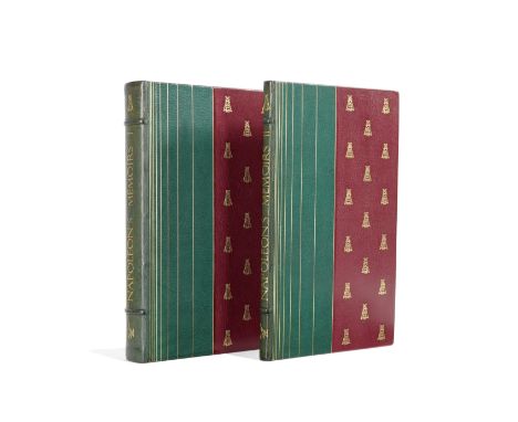
Lot 249
GOLDEN COCKEREL PRESS - JOHN BUCKLAND WRIGHTNAPOLEON I. Memoirs... Edited by Somerset de Chair, 2 vol., NUMBER 35 OF 50 SPECIALLY BOUND COPIES, from an overall edition limited to 500, signed by the editor, title-page vignette by John Buckland Wright, portrait, untrimmed in original two-tone morocco by Sangorski & Sutcliffe, left-hand green panels with 9 vertical gilt rules, right-hand dark red panels with gilt Napoleonic bees, gilt lettered spines with bee and cockerel tools and 2 raised bands, morocco turn-ins and map endpapers (slightly browned at edges), t.e.g., folio, Golden Cockerel Press, 1945This lot is subject to the following lot symbols: •• Zero rated for VAT, no VAT will be added to the Hammer Price or the Buyer's Premium.For further information on this lot please visit Bonhams.com
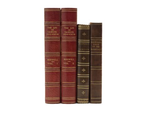
Lot 55
BOSWELL (JAMES)An Account of Corsica. The Journal of a Tour to that Island, FIRST EDITION, engraved vignette on title, folding engraved map (old tear), modern calf gilt, Glasgow, Edward and Charles Dilly, 1768; The Journal of a Tour to the Hebrides, sixth edition, engraved portrait, later half calf, T. Cadell and W. Davies, 1813; idem, limited to 2000 copies, publisher's quarter morocco, slipcase, New York, Limited Editions Club, 1974; The Life of Samuel Johnson, 2 vol., edited by Roger Ingpen, red crushed half morocco gilt by Bayntun of Bath, t.e.g., George Bayntun, 1925; Private papers from Malahide Castle in the collection of Ralph Heyward Isham, 18 vol. (of 19, lacking volume 4, and with 'Journal of a Tour to the Hebrides'), bookplate of Sir Frederick Richmond, publisher's cloth-backed boards, paper label on spines, volume 4 lacking spine, some fading, Privately Printed, [1928-1934-1936]--James Boswell's Book of Company at Auchinleck 1782-1795. Edited by The Viscountess Eccles [Mary Hyde] and Gordon Turnbull, publisher's cloth, Roxburghe Club, 1995--POTTLE (FREDERICK A.) Boswell and the Girl from Botany Bay, limited to 500 copies, publisher's cloth-backed boards, slipcase, New York, Viking Press, 1917, various sizes; and approximately 45 others by or about James Boswell (c.70)Footnotes:Provenance: The Library of the late A.J. Karter.This lot is subject to the following lot symbols: •• Zero rated for VAT, no VAT will be added to the Hammer Price or the Buyer's Premium.For further information on this lot please visit Bonhams.com
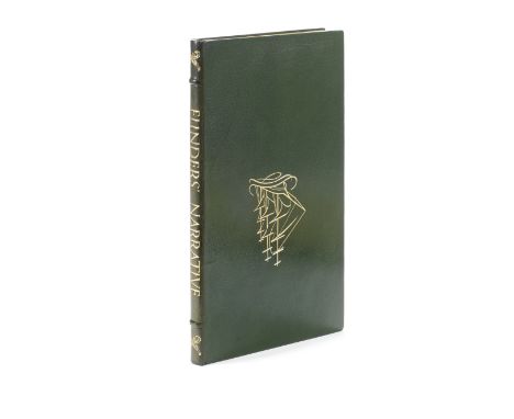
Lot 245
GOLDEN COCKEREL PRESS - JOHN BUCKLAND WRIGHTFLINDERS (MATTHEW) Narrative of his Voyage in the Schooner Francis: 1798..., NUMBER 100 OF 100 SPECIALLY BOUND COPIES, from an edition overall edition of 750 copies, printed in green and black, wood-engraved illustrations by John Buckland Wright, map, original pictorial green morocco, gilt, by Sangorski & Sutcliffe, t.e.g., cloth slip-case (a little soiled) [Cockalorum 170], small folio, Golden Cockerel Press, 1946This lot is subject to the following lot symbols: •• Zero rated for VAT, no VAT will be added to the Hammer Price or the Buyer's Premium.For further information on this lot please visit Bonhams.com

Lot 37
WORLD MAPHONDIUS (HENRICUS) Nova totius terrarum orbis geographica ac hydrographica tabula, hand-coloured double-page engraved twin-hemisphere World map, decorated with scenes of the four elements and portraits of Jodocus Hondius, Gerard Mercator, Claudius Ptolemy and Julius Caesar, French text on verso, short tear and repair at lower part centre-fold, strengthened with old paper at vertical margins on verso [Shirley 336, State 1], 380 x 550mm., [Amsterdam], 1630 [1633]Footnotes:Hondius' 'new world map is a fine ornate example of the decorative cartography of the time' (Shirley).This lot is subject to the following lot symbols: •• Zero rated for VAT, no VAT will be added to the Hammer Price or the Buyer's Premium.For further information on this lot please visit Bonhams.com

Lot 36
WELLS (EDWARD)A New Sett of Maps both of Ancient and Present Geography, AUTHOR'S PRESENTATION COPY, 39 engraved maps (of 41, lacking 'Modern' World, and Europe), 'Ancient' World map defective, 4 maps with minor loss at old fold, all maps laid down, the title and list of contents laid down on one sheet, modern half morocco [ESTC R12668; cf. Phillips Atlases, 531], folio (415 x 555mm.), Oxford, at the Thetare, 1700Footnotes:AUTHOR'S PRESENTATION COPY, inscribed on the contents leaf 'Liber Scholae Southton 1700. Donum Authoris'. Maps include North America, 'English Plantations in America', South America, Great Tartary and China, East Indies, and Turkey in Europe.This lot is subject to the following lot symbols: •• Zero rated for VAT, no VAT will be added to the Hammer Price or the Buyer's Premium.For further information on this lot please visit Bonhams.com
-
109182 item(s)/page