We found 109182 price guide item(s) matching your search
There are 109182 lots that match your search criteria. Subscribe now to get instant access to the full price guide service.
Click here to subscribe- List
- Grid
-
109182 item(s)/page


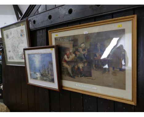
Lot 400
John Speed, 'Britain as it was divided in the tyme of the Englishe Saxons especially during their Heptarchy', sold by Thomas Bassett and Richard Chiswell, hand-coloured engraved map, 38.5cm x 51.5cm, framed and double-glazed to show the text to the reverseCONDITION REPORTS & PAYMENT DETAILSIMPORTANT * Descriptions do not include condition reports. Please contact us to if you require further information or images. * Please consider shipping costs before bidding as this may affect your decision to bid * Please familiarise yourself with our payment methods. Our preferred method of payment is by bank transfer. We do not take cash or card payments.

Lot 401
John Speed, 'The Invasions of England and Ireland with al their Civill Wars since the Conquest', sold by Thomas Bassett and Richard Chiswell, hand-coloured map engraved by Cornelius Danckerts, 38.5cm x 52cm, framed and double glazed to show text to the reverseCONDITION REPORTS & PAYMENT DETAILSIMPORTANT * Descriptions do not include condition reports. Please contact us to if you require further information or images. * Please consider shipping costs before bidding as this may affect your decision to bid * Please familiarise yourself with our payment methods. Our preferred method of payment is by bank transfer. We do not take cash or card payments.

Lot 402
John Speed, 'Sussex Described and divided into Rapes, with the situation of Chichester the cheife citie thereof and the armes of such nobles as have bene dignified with the title of Earles since the conquest and other accidents therein observed' after John Norden, sold by Thomas Baysitt and Richard Chiswell, engraved hand coloured map with inset city plan of Chichester, 39cm x 51.5cm, framed and double-glazed to show the text to the reverse.CONDITION REPORTS & PAYMENT DETAILSIMPORTANT * Descriptions do not include condition reports. Please contact us to if you require further information or images. * Please consider shipping costs before bidding as this may affect your decision to bid * Please familiarise yourself with our payment methods. Our preferred method of payment is by bank transfer. We do not take cash or card payments.

Lot 403
William Kip, 'Cornwall Olim pars Danmoniorum', after Christopher Saxton, published in 1607 (first edition) for Camden's Britannia, hand-coloured engraved map, with inset view of Launceston, 30cm x 39.5cm, framed and glazedCONDITION REPORTS & PAYMENT DETAILSIMPORTANT * Descriptions do not include condition reports. Please contact us to if you require further information or images. * Please consider shipping costs before bidding as this may affect your decision to bid * Please familiarise yourself with our payment methods. Our preferred method of payment is by bank transfer. We do not take cash or card payments.

Lot 404
William Kip, 'Somersettensis Comitatus Vulgo Somersettshyre Qui olim pars suit. Bel Garum', after Christopher Saxton, published for Camden's Britannia, early 17th century hand-coloured engraved map, 28.5cm x 39cm, framed and glazedCONDITION REPORTS & PAYMENT DETAILSIMPORTANT * Descriptions do not include condition reports. Please contact us to if you require further information or images. * Please consider shipping costs before bidding as this may affect your decision to bid * Please familiarise yourself with our payment methods. Our preferred method of payment is by bank transfer. We do not take cash or card payments.
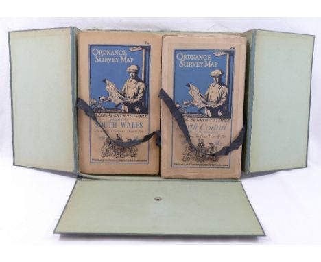
Lot 406
A collection of vintage Ordnance Survey folding maps comprised of a cased set of 10 maps of Scotland, scale 4 miles to 1 inch, another similar cased set of maps of England,and Wales (maps 2 and 12 lacking), with an additional Midlands map from the same series, published by Colonel Sir Charles Close, a Bartholomew's 'Sussex' map and another 'Kent' and one other folding map of North DartmoorCONDITION REPORTS & PAYMENT DETAILSIMPORTANT * Descriptions do not include condition reports. Please contact us to if you require further information or images. * Please consider shipping costs before bidding as this may affect your decision to bid * Please familiarise yourself with our payment methods. Our preferred method of payment is by bank transfer. We do not take cash or card payments.


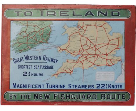
Lot 890
GWR Pictorial Enamel Map TO IRELAND BY THE NEW FISHGUARD ROUTE GREAT WESTERN RAILWAY SHORTEST SEA PASSAGE MAGNIFICENT TURBINE STEAMERS 22 1/2 KNOTS. This is the extremely rare, small version measuring approximately 15in x 11.25in. In very good condition with some small areas of restoration mainly around the edges.


Lot 1226
INDIANA JONES AND THE DIAL OF DESTINY (2023) - Crew Cap & Travel BagA crew cap and bag from James Mangold's adventure sequel, Indiana Jones and the Dial of Destiny, that were gifted to a production team member. The six-panel mid-crown baseball cap is made of navy-blue cotton. Embroidered in gold across the front is "Indy" and across the back "Crew Xmas 2021".The rectangular travel bag is made of beige canvas polyester with stitched leather trim and dual leather handles connected to vertical buckle straps. Also featured are vertical and horizontal side and top zippers; a canvas shoulder strap; and leather zip pulls engraved "Indy". The inside of the bag has fabric inlay displaying filming locations on a world map. Dimensions: (bag) 68 cm x 46 cm x 23.5 cm (27" x 18" x 9.5")Estimate: £300 - 600 †Δ View all lots from INDY 5Bidding for this lot will end on Saturday, November 11th. The auction will begin at 3:00PM BST and lots are sold sequentially via live auctioneer; tune in to the live streaming broadcast on auction day to follow the pace. Note other lots in the auction may close on Thursday, November 9th, Friday, November 10th or Sunday, November 12th.
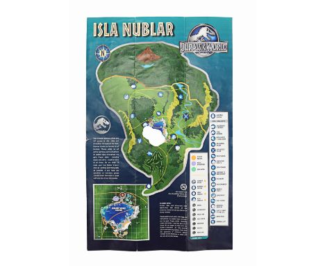
Lot 1327
JURASSIC WORLD (2015) - Brochure With Island MapA brochure that includes an island map from Colin Trevorrow's action-adventure sequel Jurassic World. Guests visiting the titular theme park were seen holding brochures as they explored the different attractions. The brochure features the park's logo on the front, along with its name printed in five different languages. Inside, the brochure lists multiple rides, exhibits, activities and other details about the park. It also includes a labelled map of the island of Isla Nublar, with a key. The logos of Jurassic World's sponsors, such as Coca-Cola, Samsung, Starbucks and American Airlines, can also be found inside the brochure. Dimensions: 44 cm x 28.5 cm (17 1/4" x 11 1/4")Estimate: £1,500 - 3,000 M View all lots from JURASSIC WORLD (2015)View all lots from JURASSIC PARK FRANCHISE (1993 - 2022)Bidding for this lot will end on Sunday, November 12th. The auction will begin at 3:00PM BST and lots are sold sequentially via live auctioneer; tune in to the live streaming broadcast on auction day to follow the pace. Note other lots in the auction may close on Thursday, November 9th, Friday, November 10th or Saturday, November 11th.

Lot 1497
THE RETURN OF THE MAN FROM U.N.C.L.E. (1983) - Peter Nelson Collection: J.B.'s (George Lazenby) Light-up Car GadgetsJ.B. 's (George Lazenby) car gadgets from Ray Austin's secret agent action film The Return of the Man from U.N.C.L.E. In a cameo appearance, J.B. (intended as James Bond but, due to legal reasons, couldn't explicitly be named as such) used the gadgets in his Aston Martin DB5 to take out the cars chasing Napoleon Solo (Robert Vaughn). The cameo was a nod to Ian Flemming, who had a hand in creating the original 1964 television series.The car gadgets feature a control panel with bulbs and functioning switches disguised inside a black leather-covered wooden box and a Sat Nav box (ultimately unseen on screen) which includes two bulbs hidden in the interior and an exterior screen made up of green tinted plastic and hand-drawn map lines and printed grids on acrylic sheets. The electronics in each gadget are connected by wiring to an AC/DC adapter which lights up the bulbs when plugged into mains. The gadgets exhibit areas of dirt, and a corner of rubber is missing from the Sat Nav. Dimensions: 36 cm x 36 cm x 22.5 cm (14 1/4" x 14 1/4" x 9")Contains electronics; see electronics notice in the Buyer's Guide.From the personal collection of Peter Nelson, previously displayed at his two museums, "The Cars of the Stars" and "The Bond Museum" in Keswick, Cumbria, until they closed in 2011.Estimate: £600 - 1,200 M View all lots from RETURN OF THE MAN FROM U.N.C.L.E. (1983)Bidding for this lot will end on Sunday, November 12th. The auction will begin at 3:00PM BST and lots are sold sequentially via live auctioneer; tune in to the live streaming broadcast on auction day to follow the pace. Note other lots in the auction may close on Thursday, November 9th, Friday, November 10th or Saturday, November 11th.

Lot 268
THE MUMMY (1999) - Hamunaptra MapA Hamunaptra map from Stephen Sommers' fantasy adventure The Mummy. After stealing the map from Rick O'Connell (Brendan Fraser), Jonathan Carnahan (John Hannah) presented his sister and aspiring Egyptologist, Evelyn Carnahan (Rachel Weisz), with a map. The map led the explorers to Hamunaptra, the "City of the Dead", but it was later destroyed in a fire when the Medjai ambushed their boat.The map features ancient Egyptian hieroglyphs, images of mythological gods, and significant landmarks that form the map, such as the River Nile. It has been printed on a piece of thin rectangular paper, intentionally stained and distressed so that it resembles ancient papyrus. Dimensions: 42.5 cm x 29.5 cm (16 3/4" x 11 1/2")Estimate: £4,000 - 8,000 M View all lots from MUMMY, THE (1999)View all lots from MUMMY - ALL ITEMSBidding for this lot will end on Thursday, November 9th. The auction will begin at 3:00PM BST and lots are sold sequentially via live auctioneer; tune in to the live streaming broadcast on auction day to follow the pace. Note other lots in the auction may close on Friday, November 10th, Saturday, November 11th or Sunday, November 12th.

Lot 278
PADDINGTON 2 (2017) - Landmarks of London Pop-up BookA Landmarks of London pop-up book from Paul King's 2017 comedy sequel Paddington 2. Paddington (Ben Whishaw) was falsely accused of stealing a valuable pop-up book from Mr Gruber's (Jim Broadbent) antique shop. Unbeknownst to Paddington, the book was a treasure map of clues, with a letter at each landmark corresponding to a musical note, which, when played on the Steam Fair organ, revealed a hidden treasure. This handmade pop-up book has a printed illustrated cover and decorative brass-toned metal corner protectors applied over a canvas hardback exterior. The interior contains two illustrated pop-up scenes made from hand-cut pieces of printed card, each featuring a letter handwritten in pencil; the Buckingham Palace scene features a "G", while the Houses of Parliament scene features an "E". The book exhibits intentional distressing to appear antique. Additional scuffs, scratches and canvas tears are present from production use. Dimensions: 32 cm x 26 cm x 3 cm (12 1/2" x 10 1/4" x 1 1/4")Estimate: £6,000 - 12,000 M View all lots from PADDINGTON 2 (2017)Bidding for this lot will end on Thursday, November 9th. The auction will begin at 3:00PM BST and lots are sold sequentially via live auctioneer; tune in to the live streaming broadcast on auction day to follow the pace. Note other lots in the auction may close on Friday, November 10th, Saturday, November 11th or Sunday, November 12th.
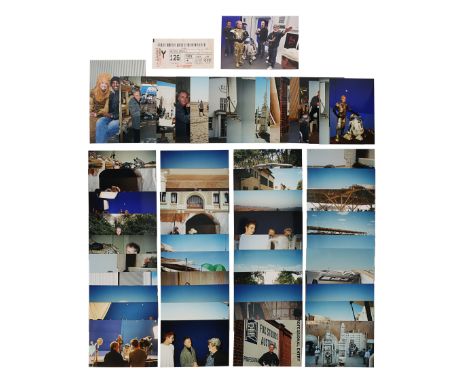
Lot 706
STAR WARS: ATTACK OF THE CLONES (2002) - Anthony Daniels Collection: Anthony Daniels' Personal On-set Photographs and Plane TicketAnthony Daniels' personal on-set photographs and a plane ticket from the production of George Lucas' Star Wars: Attack of the Clones. This lot comprises 72 colour photographs taken behind the scenes of Lucas' second Star Wars prequel. Many feature Daniels himself, while some also show other members of the cast and crew, including Lucas, Ewan McGregor, Christopher Lee, Hayden Christensen and Natalie Portman. Also included is Daniels' Tunisair plane ticket and an invitation to a pre-shoot drinks with an accompanying map to the venue. Dimensions (largest photo): 19 cm x 12.5 cm (7 1/2" x 5") Sold without copyright; see copyright notice in the Buyer's Guide.Additional Provenance: This lot comes from the personal collection of actor Anthony Daniels. Daniels plays loyal protocol droid C-3PO in the Star Wars saga. He first appeared in the role in 1977 and is the only actor to appear in all Star Wars feature films to date.Estimate: £500 - 1,000 M View all lots from STAR WARS: ATTACK OF THE CLONES (2002)View all lots from STAR WARS - ALL ITEMSBidding for this lot will end on Friday, November 10th. The auction will begin at 3:00PM BST and lots are sold sequentially via live auctioneer; tune in to the live streaming broadcast on auction day to follow the pace. Note other lots in the auction may close on Thursday, November 9th, Saturday, November 11th or Sunday, November 12th.

Lot 10
Mazzella (Scipione) Sito, et Antichita della Citta di Pozzvolo e del Suo Amenissimo Distretto, second edition, folding woodcut map tipped in, illustrations, modern cloth, morocco spine label, [Adams M954], 12mo, Naples, nella stamparia dello Stiglioloa, 1593.⁂ The rare second edition of a detailed Italian account of archaeological discoveries in and around the city of Pozzuolo in central Italy, between Rome and Florence, with a large folding map and numerous illustrations of the archaeological sites, buildings, objects excavated, etc., and transcriptions of inscriptions, by the Naples historian Scipione Mazzella, famous for his Descrizione dello Regno di Napoli.
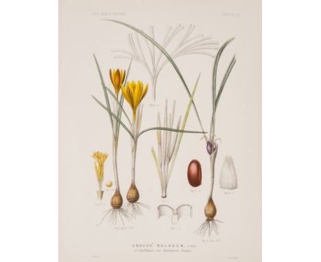
Lot 259
Maw (George) A Monograph of the Genus Crocus, first edition, 81 hand-coloured lithographed plates, double-page colour map and two double-page tables, hinge cracked, light foxing to half-title, contemporary green morocco with gilt letter title to upper cover, lightly rubbed, g.e., [Nissen BBI, 1316; Stafleu & Cowan 5721], 4to, 1886.⁂ "George Maw (1839-1912) was the industrious author and illustrator of his great 'Monograph of the Genus Crocus' (1886)...His monograph, the result of ten years of inquiry, was the most complete work of its kind that has been published on any genus. The plates of this work are marvels of comprehensive detail and put to shame those of many more skilled draughtsmen. From a botanical point of view this work is a landmark." - Blunt & Stearn, pp.277 & 279.

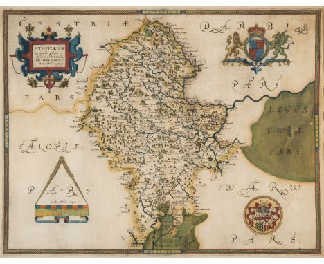
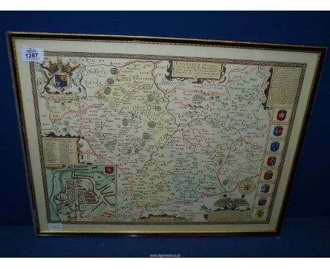
Lot 278
Staffordshire.- Saxton (Christopher) Staffordiae Comitatu pfecte et absolute elaboratu haec tibi tabula exhibit, county map with strapwork title cartouche upper left, royal arms of Elizabeth I upper right, arms of Thomas Seckford lower right, large compasses and scale lower left, engraved map by Francis Scatter, with original hand-colouring, 390 x 510 mm (15 1/8 x 20 in), under glass, two large repairs to loss within the green pigment at centre right and lower centre, some careful pen facsimile additions to both, minor surface dirt, framed, [1579].
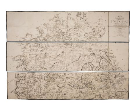
Lot 279
Wiltshire.- Andrews (John) and Andrew Dury. A Topographical Map of the County of Wilts, Describing the Seats of the Nobility and Gentry, Turnpike and Cross Roads, Canals, &c., Surveyed Originally in 1773..., Second edition, large scale county map in six horizontal sections, calligraphic title, large vignette after Cipriani in the lower left, table of the market towns and villages, separate engraved general index map, engravings with outline hand-colouring, each map section approx.480 x 1925 mm (18 7/8 x 75 3/4 in), dissected and mounted on linen, edged with green-coloured linen, some offsetting, minor toning, a few splits to folds on the general index map sheet, folding with blue end-panels, modern slipcase, 4to, William Faden, 1810.
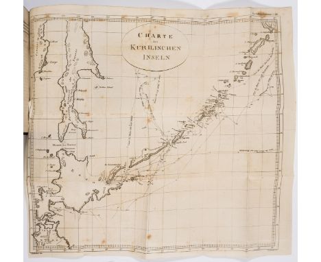
Lot 283
Japan.- Golovnin (Vasily Mikhailavich) Begebenheiten des...Gesangenschaft bei den Japanern..., 2 vol. in 1, translated by Carl Johann Schultz, engraved portrait and 6 folding map and plans (1 with small tear), browned, contemporary half calf, new leather label on spine, [Cordier, BJ 464; Henze II, 366], 8vo, Leipzig, Gerhard Fleischer, 1817-18.⁂ Captain Golovnin (1776-1831) was captured by the Japanese while mapping and exploring the coast of Kamchatka, Alaska and the Kurile Islands to which he had been sent by the Russian authorities in 1807 (he was the first to provide an accurate map of the Kurile Islands). He was kept imprisoned in Japan for two years (1811-1813). The work contains notes written by Golovnin of his imprisonment, based on his experience and observations.

Lot 8
Bible, French.- La Bible, qui est toute la saincte escriture, 2 parts in 1, double column, 5 woodcut maps, of which 4 folding, folding woodcut table, woodcut illustrations, music, head- and tail-pieces and decorative initials, NT title within ornate woodcut floral and foliage border, RR6 blank, ruled throughout in red, map of Mediterranean in Numbers with some loss and laid down, map of Holy Land at start of NT with short tear within image, without loss, map in Acts with a couple of short tears without loss and laid down, *4 trimmed just within printed side-notes, NT DD2 neat short tear at head within printed side-notes, heavily water-stained at start (including Eden map), some water-staining or soiling elsewhere, occasional spotting, lightly browned, [Adams B1145; D&M 3730; cf. Renouard, Estienne, 159:7], [Geneva], François Estienne, 1567 bound with Calendrier historial, printed in red and black, title within ornate woodcut floral and foliage border, woodcut illustrations, *v with very short tear without loss, some spotting or staining, lightly browned, [cf. Adams C195], [Geneva], François Estienne, 1567, together 2 works in 1 vol., 19th century blind-stamped calf, spine in compartments and with gilt title, upper cover detached, corners worn, rubbed and marked, 8vo
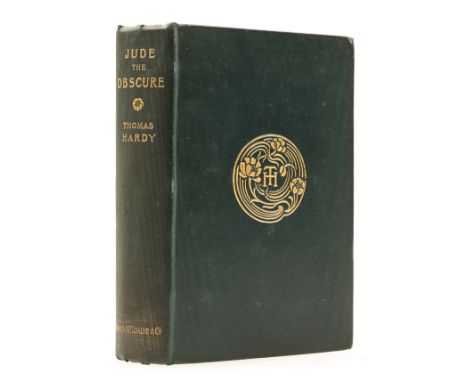
Lot 88
Hardy (Thomas) Jude the Obscure, first edition in book form, etched frontispiece by H. MacBeth-Raeburn, tissue guard, map of Hardy's 'Wessex' at end, W.W.Greg's copy with his ink inscription "W.W.Greg River 1949" to front free endpaper, original dark green cloth, gilt, t.e.g, others uncut, slightly rubbed and marked, a little cocked but a good copy, [Purdy pp.86-87], 8vo, 1896 [but 1895].⁂ Hardy's final novel, ahead of its time. Aimed at Victorian institutions such as the Church, marriage and education, and with a modern heroine in the "new woman" Sue Bridehead, this tragic story was vilifed by many whose moral indignation was roused by Hardy's controversial themes. It has been suggested that he was so distressed at how the book was received and misunderstood that he gave up writing novels and concentrated on poetry.Sir Walter Wilson Greg (1875-1959), bibliographer and Shakespeare scholar.

Lot 404
Amerika - Nordamerika - - Hondius, Henricus & Johannes Janssonius. America septentrionalis. Kolorierte Kupferstichkarte. Amsterdam, 1638. Plattenmaße: 46,5 x 55 cm. Blattgröße: 50 x 59 cm.Die berühmte Nordamerika-Karte aus dem "Atlas Novus" in schönem zeitgenössischen Flächenkolorit, erste Fassung ohne Text in der kleineren der beiden Kartuschen. Lateinischer Rückentext. - "Hondius' beautifully engraved map of North America had greater influence than any other to date in perpetuating the theory of California as an island." (Burden). - Umlaufend kleine Randeinrisse, am Falz und einmal rechts bis in die Platte, eine Ecke mit Knickspur knapp am Plattenrand.
Lot 54
Geologie - - Tjäder, J. J. Karta öfver Fahlu eller Stora Kopparbergs grufwor sammandragen och utgifven �r 1845. (Map of the Falun or Great Copper Mountain Mine). Mit gestochenem Titel und 39 kolorierten gestochenen Karten. Falun, Akerblom, 1845. 4 Bl. 37 x 27 cm. Halbleinwand der Zeit (Rücken mit Fehlstellen).Mit jeweils 2 Blatt (6 Spalten) Textanhang auf Schwedisch: "Korta underrättelser om Stora Kopparbergs Grufva" und auf Deutsch: "Kurze Nachrichten über Stora Kopparbergs Grube", gedruckt bei Hörberg, Stockholm. - Textblätter teils gebräunt.


Lot 1790
A collection of books on mixed themes in one tray to include A Short History of the English People by John Richard Green., Two Vols. The Studio Yearbook of Decorative Arts 1907 & 1911., Five Centuries of Maps and Map-Making., The Roman Wall in Scotland, George Macdonald, 1934., A Short History of the Port of Bristol by Charles Wells, 1909. Also includes several small pamphlets relating to surveying.


Lot 540
TRAVEL: three antiquarian/vintage books in need of some attention/restoration. First, PLAYNE, Somerset, 'Southern Indian History, Commerce and Industrial Resources'. 766 pp in a very clean ed. The Foreign & Colonial Compiling Publishing Co., 1916; with HELPS, Arthur (ed.), 'Leaves from the Journal of our Life in the Highlands [Scotland] from 1848-1861' etc. Illus. ed., Smith Elder 1868, Nice plates/pictures but a no. of loose pages. Then, McCALLUM, Pierre F., 'Travels in Trinidad During the Months of February, March and April 1802 in a Series of Letters etc.' Front board detached (present), map present. Liverpool, 1805.


-
109182 item(s)/page