We found 109198 price guide item(s) matching your search
There are 109198 lots that match your search criteria. Subscribe now to get instant access to the full price guide service.
Click here to subscribe- List
- Grid
-
109198 item(s)/page


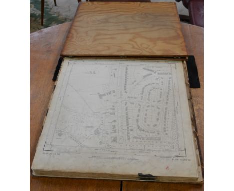
Lot 300
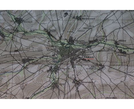
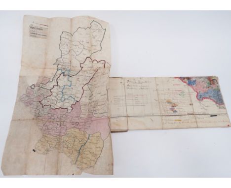
Late 19th Century Military Campaign Maps of India. The first map is printed covering the area Balaghat, This printed in 1882 Calcutta. The map has been hand coloured and bears a large amount of hand written notes etc. ... The second map is hand drawn and coloured on a wax vellum paper. Titled Pregnant. GC some service wear. (2 items)Used by Major Charles Hanford Baldwin Clark York & Lances Regiment & Indian Army See lot 484 for his medals and ephemera and lot 970 for his sword.

Lot 125
A G. F. Cruchley's table 10" globe, 12 hand coloured engraved gores, The Catourche 'Cruchley's new terrestrial globe showing the latest discoveries towards the North Pole, equatorial Africa, Australia, New Zealand & C. London G.F. Cruchley map seller, globe maker and publisher, 81 Fleet Street, London. Dated 1867. The globe is seated in a replacement mahogany stand. Globe Diameter 24cm. Height with stand 32cm.


Lot 960
Collection of Shropshire and Staffordshire Golf Club Handbooks (5) - Shifnal Golf Club by Tom Scott, Bridgnorth Golf Club - how things have changed ; Shrewsbury Golf Club by J W Walker (now municipal) ; Oswestry Golf Club (showing the old club house) and Enville Golf Club before the club house moved over to the other side of road and additional 18 holes and a later road map showing the new positon of the club house (6)

Lot 962
Collection of Golf Club Handbooks (5) -Ganton Golf Club by Robert H.K Browning post Ryder Cup with photgraph of Ben Hogan and c/w folding course plan and map; North Cliff Golf Club Scarborough by Tom Scott; Southport & Ainsdale Golf Club by Robert H.K. Browning covers stained and soiled (AF); Shifnal Golf Club see p. 7 (which will put anyone off from playing there!!) and How to Play Little Aston Golf Course by Charlie Ward covers soiled and one page has a sellotape repair


Lot 4
John Owen & Emanuel Bowen (fl.1714 - 1767), an eight-page ogilby-type strip road map, plates 13 -20 from Thomas Bowles Britannia Depicta, 18th century copper plate engravings, coloured, armorial vignettes of the Arms of Huntingdon, Hartford, Grantham, Newark, Stamford, Durham and Newcastle, framed, 18cm x 97.5cm


Lot 196
Books: Bucklebury, a Berkshire Parish by Arthur L. Humphreys, F.S.A., published at York Lodge, Reading 1932, leather bound spine, uncut edges, map now loose; The Foresters Guide and Profitable Planter by Robert Monteath 1824 2nd edition; the Rubaiyat of Omar Khayyam, London Kegan Paul Trench, Trubner & Co 1912 and Alice's Adventues in Wonderland, Lewis Carroll Centenary edition (4)


Lot 1603
20th century AD. A pair of wooden spears painted in black pigment with white tips and a white and ochre net pattern to the body with collars of ochre and white; one long straight point tapering to both ends; one with a series of five barbs to the side and tapering to a point. See Jelinek, J. The Great Art of the Early Australians: The Study of the Evolution and Role of Rock Art in the Society of Australian Hunters and Gatherers, Brno, 1989. 66 grams total, 42.5cm (16 3/4"). Property of a European collector; formerly from the collection of Prof. RNDr. Jan Jelínek, DrSc., anthropologist, and Director of the Moravian museum, and the president of the International Committee of Museums (ICOM) for eight years; thence by descent 2004; collected by Professor Jelínek during the Moravian Museum expedition collaboration with Department of Aboriginal studies in Canberra, to Arhnem Land in the Northern Territory of Australia, in 1969. Accompanied by copies of expedition photographs, map and Dr Jelinek's biography. [No Reserve, 2] Very fine condition.

Lot 201
20th century AD. A wooden figure of a male(?) with drum-shaped head painted in black pigment to the face with the facial details in white pigment with dark ochre for the nose; to the top of the head half in dark ochre the other half in light, a collar of light ochre to the neck; long arms to the side of the body with a panel to the centre of geometric motifs; to the back a series of three figures with spears; long straight legs painted in dark ochre with white to the feet, painted rectangles to the side of the legs with net pattern. See Jelinek, J. The Great Art of the Early Australians: The Study of the Evolution and Role of Rock Art in the Society of Australian Hunters and Gatherers, Brno, 1989; Isaacs, J. Tiwi, Melbourne, 2012. 748 grams, 50cm (19 1/2"). Property of a European collector; formerly from the collection of Prof. RNDr. Jan Jelínek, DrSc., anthropologist, and Director of the Moravian museum, and the president of the International Committee of Museums (ICOM) for eight years; thence by descent 2004; collected by Professor Jelínek during the Moravian Museum expedition collaboration with Department of Aboriginal studies in Canberra, to Arhnem Land in the Northern Territory of Australia, in 1969; from Tiwi Island, Australia. Accompanied by copies of expedition photographs, map and Dr Jelinek's biography. The Tiwi Islands are eighty kilometres north of Darwin, where the Arafura and Timor Seas meet. They are comprised of Melville and Bathurst Islands and are Australia’s second and fifth largest islands respectively. Contemporary Tiwi artists draw on the elaborate decoration of traditional ceremonies, including painting patterns on the body, carving and decorating ceremonial hollow log funeral poles, the creation of elaborate head-dresses and other body adornments, weaving and printmaking borne from the tradition of ceremonial Pukamani poles. Tiwi art differs from that of the people of nearby Arnhem Land in its vibrant colour and emphasis on pattern. This figure represents an ancestor figure and these traditionally feature geometric patterns along with depictions of spirits and ancestors, and are placed around gravesites. Very fine condition.

Lot 202
20th century AD. A wooden figure of a goanna (Australian monitor lizard) with long head, slit to the front for the mouth, eyes drilled, painted in black pigment with white dot pattern; short legs to the front and back and short tail with notches to the top; large oval and flat body painted with a series of black and ochre panels with net-and-dot pattern; to the underside black background with white dot pattern. See Jelinek, J. The Great Art of the Early Australians: The Study of the Evolution and Role of Rock Art in the Society of Australian Hunters and Gatherers, Brno, 1989. 210 grams, 34.5cm (13 1/2"). Property of a European collector; formerly from the collection of Prof. RNDr. Jan Jelínek, DrSc., anthropologist, and Director of the Moravian museum, and the president of the International Committee of Museums (ICOM) for eight years; thence by descent 2004; collected by Professor Jelínek during the Moravian Museum expedition collaboration with Department of Aboriginal studies in Canberra, to Arhnem Land in the Northern Territory of Australia, in 1969. Accompanied by copies of expedition photographs, map and Dr Jelinek's biography. [No Reserve] Fine condition.

Lot 206
Late 19th-early 20th century AD. A knife with obsidian blade, roughly pyramidal in section, with knapped edges to two sides, flat to the underside; wooden handle made from the fruit of the tree Atuma Rocemosa“ with geometric motifs coloured with white, red and black natural pigments in the form of inverted triangles and rosettes. For a similar knife see The British Museum, accession number Oc1928,0314.54; and Ohnemus, S. An Ethnology of the Admiralty Islands, Hawai'i, 1998. 246 grams, 30.5cm (12"). Property of a European collector; formerly from the collection of Prof. RNDr. Jan Jelínek, DrSc., anthropologist, and Director of the Moravian museum, and the president of the International Committee of Museums (ICOM) for eight years; thence by descent 2004; from the Admiralty Islands, Papua New Guinea; acquired by Professor Jelínek during the Australasian expedition in 1969. Accompanied by copies of expedition photographs, map and Dr Jelinek's biography. [No Reserve] Fine condition.
-
109198 item(s)/page