We found 109198 price guide item(s) matching your search
There are 109198 lots that match your search criteria. Subscribe now to get instant access to the full price guide service.
Click here to subscribe- List
- Grid
-
109198 item(s)/page


Lot 105
Maps from the Age of Discovery - A New Worlds map book from the Age of Discovery, full colour illustrated maps from 1475 - 1899 by Ashley and Miles Baynton-Williams, approx size 37 cm x 44 cm, with dustcover and three good quality fashion Radley handbags in original dust covers comprising a black handbag with 'The familiar is made through love' hangers, a maroon handbag with short and longer handles and a black handbag with two long handles, two with the Radley dog and one with Radley disc [4]

Lot 110
A Rare 17th Century Map of the Kingdom of Poland Published c.1696, E.I. Dahlbergh, Erik Jönsson, greve (1625-1703), cartouch reads 'Auctior et correctior tabula chorographica Regni Poloniae: vicinarumque regionum, ubi itinera, quae Seren. Rex Sueciae Carolus Gustavus : una cum exercitibus suis ab initio usque ad finem belli fecit, nummeris denotantur...', from S. Pufendorf's "De rebus a Carolo Gustavo gestis" published in Nuremberg in 1696-1697, copper plate engraved, uncoloured, dimensions: printed area 37cm x 29cm, paper 42cm x 36cmNote: two unique features of this map are the many heraldic crests for the ruling families of each area and the many roads shown on the map, this is a very unusual feature for 17th Century maps, for the same map see the Harvard University collection at https://curiosity.lib.harvard.edu/scanned-maps/catalog/44-990115819690203941

Lot 111
A 18th Century Map of Poland Extending to Lithuania & the Baltic, Published c. 1703, Guillaume De L'Isle (1675-1726), cartouch reads 'La Pologne Dressee sur ce qu'en ont donne Starovolsk, Beauplan, Hartnoch…', detailed map of Poland at the beginning of the 18th Century, extends to the Baltic and the Ukraine, copper plate engraving, outline colour, paper untrimmed, no restoration, dimensions: printed area 49cm x 64cm, paper 53.5cm x 72cm.

Lot 112
Two Early Maps of Poland, Printed in Cologne, c.1592, detailed map of Southern Poland and the from the Weysel River in the north to the Carpathian Mountains in the south, centered on Auschwitz, Nicholas de Fer, Paris 1705, Birds eye view of Kamieniec, key to buildings and explanation in both corners, dimensions 35cm x 26cm

Lot 113
A 17th Century Map of Poland, Including Coats of Arms, Cherubs and Cartouches, Published in Amsterdam, C.1635, Willem Janszoon Blaeu (1571-1638), cartouche reads ‘Polonia Regnum et Silesia Ducatus’ copper plate engraving, uncoloured, Latin text to verso, untrimmed, dimensions: printed area 54cm x 43cm, paper 60.5cm x 50cm

Lot 114
A 17th Century Map of Poland, Including Coats of Arms, Cherubs and cartouches published c.1680, J. Janssonius – Moses Pitt, cartouche reads ‘Novissima POLONIAE REGNI description, copper engraving hand coloured, verso with Latin text, untrimmed, dimensions: printed area 54cm x 43cm, paper 60.5cm x 50.5cm.Note: From the English atlas. Oxford, Moses Pitt, 1680
Lot 115
A Very Fine 17th Century Map of Poland, published in Amsterdam c.1665, Blaeu, Joan, (1596-1673), cartouche reads 'PALatinATVS POSNANIENSIS IN MAIORI POLONIA PRIMARII NOVA DELINEATIO. Per G. F. M.' copper plate engraving, hand coloured, untrimmed, no restoration, French text to verso, dimensions: printed area 53cm x 41cm, paper 56cm x 55cm.Note: Taken from ‘Atlas Maior Sive Cosmographia Blaviana, Qua Solvm, Salvm, Coelvm, Accvratissime Describvntvr’, Blaeu's 11 volume Atlas Major considered by many to be the greatest atlas ever published, both in its own time and even today. It excels in comprehensiveness, engraving, colour, and overall production.

Lot 116
A Large 18th Century Map of Poland, published in Paris, C.1738, Guillaume De l'Isle's (1675-1726), cartouche reads 'La Pologne. Chez l’Auteur sur le Quai de l’Horloge a la C. ne de Diamãs. Avec Privilege du Roy, et se trouve a Amsterdam chez L Renard prez de la Bourse', copper plate engraving, hand coloured borders, untrimmed, no restoration, dimensions: printed area 63cm x 48cm, paper 72cm x 54cm

Lot 117
A Rare Map of Poland and Prussia, C.1714, Pierre van der Aa (1659-1733), cartouche reads 'Grande Pologne et Prusse avec les frontieres de la Misnie, Lusace, Moravie et Lithuanie . . .' copper plate engraving, hand coloured, no restoration, dimensions: printed area: 36cm x 29cm, paper 40cm x 36.5cm.

Lot 118
A Very Decorative Map of Poland with two Cartouches and two Coats of Arms, Printed in Amsterdam, Willem Janszoon (or Jansz.) Blaeu (1571 - 1638) , C. 1648, cartouch reads 'Polonia regnum et Silesia ducatus', copper plate engraving, hand coloured, untrimmed, map showing the region from the Oder east to Podlachia with parts of Prussia and Brandenberg, dimensions: printed area 51cm x 41.5cm, paper 61cm x 51cm

Lot 119
An Early Decorative Map of Poland & Lithuania, C.1697, printed in Amsterdam, cornelium Danckerts, catouch reads 'Regni Poloniae et ducatus Lithuaniae Voliniae Podoliae Prussiae et Curlandiae descriptio emendata, cornelium Danckerts', copper plate engraving, hand coloured, dimensions: printed area 58cm x 50.5cm, paper 60.5cm x 52.5cm


Lot 121
A Detailed Map of Poland and the Baltic, c.1710, printed in Paris, Henri Abraham Chatelain (1684-1743), title reads 'Nouvelle Carte Du Royaume De Pologne, Divisee Selon Ses PaLatinates Et Ses Provinces, Avec Des Remarques Historiques . . .' copper plate engraving, dimensions: printed area 58cm x 50cm, paper 66cm x 57cm

Lot 123
A 17th Century Map of Zamosc in Poland, C.1618, titled ‘Zamoscium. Nova Poloniae civitas, à magnifico eius regni Cancellaro à fundamentis exstructa’, unusual birds-eye view of the walled city, with cartouchee to top left with names for the buildings, dimensions: printed area 46cm x 35cm, paper 53.5cm x 43cmNote: taken from ‘Theatri praecipuarum Totius Mundi Urbium Liber Sextus’

Lot 126
A Town-view of Przemysl in Poland, c.1618, printed in Cologne, Georg Braun and Frans Hogenberg, titles read 'Premislia celebris russiae civitas. - Templum S. Leonardi', copper plate engraving, dimensions: printed area 49cm x 35cm paper 58cm x 42cmNote: this map was only included in part VI of Braun and Hogenberg's town book.


Lot 103
A 17th Century Map of Lithuania, Latvia, Poland, Prussia, Belarus, Ukraine and Russia, published c. 1662, Willem Janszoon Blaeu (1570–1630), cartouch reads 'Magni Ducatus Lithuaniae et Regionum Adiacentium exacta Descriptio . . . D.Nicolai Christopheri Radziwil . . .' detailed map of Lithuania, Latvia, Poland, Prussia, Belarus, Ukraine and Russia, with French text to verso, outlie colour, paper untrimmed, no restoration, dimensions: printed area 45cm x 55cm, paper 55cm x 65cm.Note: This is Blaeu’s second map based upon Radizwill’s early map, this edition is oriented with west at the top, the map was only published in very late editions of Blaeu’s Atlas Maior.


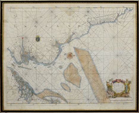
Lot 339
A 17c antique map dedicated and presented by Captain Greenvile Collins hydrographer to the King, the the Hon. Sir Ralph Delaval, Vice Admiral of the Red. This map of the East and South Coast of England and the English Channel, drawn to a scale of 20 English Leagues and the North Eastern coast of Holland and indicating the Well Banck, White Water and Broad Fourteens, framed and glazed, 8.75in x 23.5in.


Lot 212
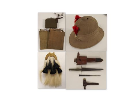
CAPTAIN C. MILLAR, BLACK WATCH, MILITARY SPORRAN pith helmet, commando dagger in scabbard with frog, two map cases, water bottle, a framed display of pips, buttons, patches, related photographs, four military "Snaffles" prints and ephemera, a military tan leather trunk painted with the owner's name and regiment, a kit case with Sam Browne belt and webbing and one other leather trunk Captain C Millar lived in Edinburgh and was a 2nd Lieutenant prior to WWII. He travelled with The Black Watch Band in the UK and USA. He was billeted in Edinburgh and Perth and then saw action in the Far East, mainly with the Fourth Division, assisting with the repatriation of captured Black Watch Divisions in Burma where he remained for the remainder of WWII. After the war he was promoted to Major and carried out training with The Territorial Army and The Black Watch Rifle Division in Perthshire prior to his retirement Condition Report: The Snaffles prints are a bit faded but no damage, the sporran is not in good condition. The pith helmet is a bit stained on the crown but no damage, the dagger is ok as are the water bottle and map cases. The webbing and Sam Browne are ok. I would say the two trunks are in fair condition. I would suggest you go to our website catalogue and click on the image. There are several views and a zoom facility. There are also multiple images on thesaleroom.com. .

Lot 2110
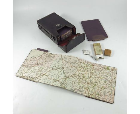
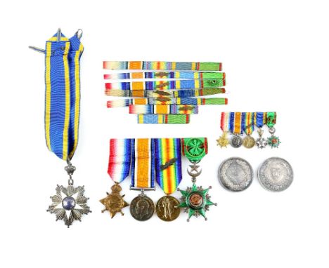
S. A. Tippetts Governor of the Northern Province of Sudan and later of the Red Sea Province, medals and documentation to include :The Order of the Nile 3rd class with Licence to Wear, 1915-15 Star, War Medal, Victory Medal with clasp for mentioned in dispatches 25th June 1917 & 26th January 1919, Order of The Osmanieh 4th Class, together with medal bars and cased miniatures, Photographic portrait in uniform by C. Vandyk Ltd,and other contemporary photographs Testimonials and References 1901, His letters of appointment to the post of Inspector in the Sudan 1902, A Map of The Anglo-Egyptian Sudan 1904,and another of Khartoum 1907, his Speech to the Ulema, 1914. various other telegrams, letters and reports. A letter from Major-General J. M. Stewart to the Idrisi Saiyaid urging more progress in driving out the Turks. Photographs taken from Idrisi Headquarters and a sketch of the Turkish positions, a rough sketch map of positions in ABS District 20th March 1918, an outline map of Loheiya Vicinity January 1918, copies of his reports to the Resident. Aden containing observations relating to the Diary of Lieut Nasiruddin Ahmed, Political Liaison Officer at Lohaiya, together with other hand written notes relating to actions in the area.Typed copies of tributes on his leaving his post as governor of the Red Sea Province and the city of Tokar, his references from General Sir Francis Reginald Wingate, and John Loader Maffey Govenor-General of the Sudan, . Please see ewbanks.co.uk for condition reports and further images


Lot 123
'A New And Correct Map Of The South Part Of SCOTLAND from the beft Authorities' engraved by John Cary (c. 1754 – 1835) was an British cartographer.L: 54cm approx H: 40cm approx Condition Report: Prior to bidding, please consult the additional photos provided and ask all pertinent questionsCondition reports are offered as a guide only and we highly recommend inspecting any lot to satisfy yourself as to its condition


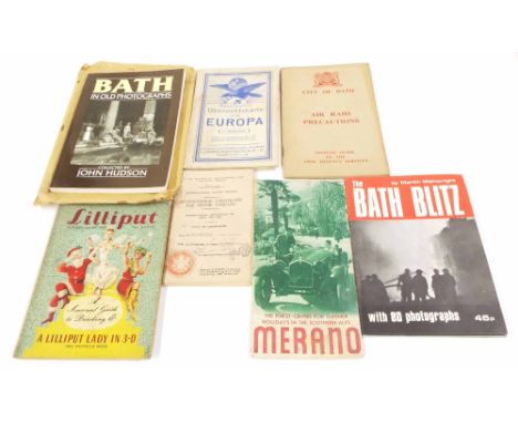
Lot 516
City of Bath - Air Raid Precautions, the official guide to the civil defense services brochure handbook; together with further vintage and wartime ephemera including Ministry of Transport International Certificate for Motor Vehicles, tourism pamphlet for Merano, Ravenstein scale map of Europe, The Bath Blitz by Martin Wainwright 1975, the 1954 seasonal Issue of Lilliput and copy of Bath in old photographs 1988


Lot 1547
Collection of Decorative Plates to include six commemorative Colliery plates, depicting Pendlebury, Parsonage, Parkside, Bickershaw, and Golborne, with a plate showing the map of Lancashire and marking out all the mines. Also, three large meat chargers, one white Spode, one with a fruit pattern and one blue and white; eight wall plates with certification; two small Chokin plates; a glass vase, a Carolyn tray, and a small Spode vase. Includes two glass oil lamps. Please see photographs. A/F


Lot 222
Unique collection of photographs and other documents relating to Karl Herrmann, a German NSKK Officer in the 21/M77 group. The NSKK, the Nationalsozialistisches Kraftfahrkorps (National Socialist Motor Corps in English) was a driver training unit. They were responsible for training German army drivers and despatch riders and, just prior to the outbreak of hostilities, also for training Panzer tank crews. They had additional responsibility for chauffeuring around high-ranking German officers and other visiting dignitaries. As some of the images in this collection show close-up, candid shots of the Nazi top brass on the podium of the 1935 Nuremberg Rally, as well as journalists and foreign diplomats etc. it is assumed that is how the photographer managed such unparalleled access.Subjects include several close-up shots of Hitler, plus Blomberg, Himmler, Rosenberg, Gobbles, Prince Wilhelm, Leni Riefenstahl, plus general shots of the stadium.Other images include numerous candid and posed photographs of German soldiers in their barracks, in training, relaxing etc.The collection includes over 70 6.5cm x 6.5cm prints of the Nuremberg Rally (mostly fully captioned); over 50 9cm x 6.5cm prints of preparing for, mustering at, and the journey to a (different?) rally along with 6-pages of detailed descriptions of the day; 15 prints 9cm x 6cm of the NSKK rally, Coburg, 20th October 1935; around 30 prints 8.5cm x 14cm (post card size) of the 38/3 Machine Gun Battalion, plus over 25 6.5cm x 6.5cm prints of various civilian and army life.Also included is a Nuremberg map with suggested routes marked in red, a train ticket, a Nazi postage stamp, 2 German uniform insignia and various other ephemera, Karl Herrmann's Wehrpas (service record book), what appear to be his 'call-up' letter, numerous letters to and from his family during his war service (including several hand coloured letters and cards from his young son) right up to a notice of his death in October 1944.The 70 'album' pages, plus numerous other documents have been transferred to a modern loose-leaf folder and a few of the punched holes impact a few of the documents, mostly in a minor way.For short video of this items, please visit tinyurl.com/rmg6pqs


-
109198 item(s)/page