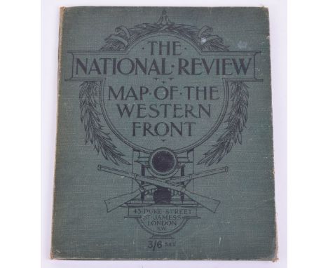
We found 109182 price guide item(s) matching your search

Refine your search

Year

Filter by Price Range
  • List
  • Grid
  • 109182 item(s)
    /page

Lot 175

The National Review Map of the Western Front, Very rare original folding linen map of the Western Front showing the Front line and movements in it from 1916 and 1917, (Somme and Verdun) Scale 10miles to 1 inch, folds into titled green cloth boards, published c.1917 in Duke Street London. Only copies located are at the National Army Museum and in a Museum in Canada. vgc.

Lot 184

Original Normandy Map (Second Army Traffic Layout 1 July 44) Overlay showing traffic routes, including tanks, from Juno Beach from King to Roger Beach landing sectors 1:50,000 Interestingly down to Caen and beyond. Very nice condition, rare

Lot 186

Original "LONDON & SUBURBS MAIN LINE RAILWAYS AND CONNECTING UNDERGROUND RAILWAYS…" Published George Philip & sons. Large map in full colour, N.D.C.1939 one tear along crease and a few points of wear, overall vgc.

Lot 235

Original Example of "THE WONDERGROUND MAP OF LONDON TOWN" Drawn by MacDonald Gill and printed and published by the Westminster Press, London. Published c.1923 shows Greyhond and "On to Wembley " in left hand corner. In bright fresh condition, no additional backing, just a small 1inch tear and folding. Nice example of a rare classic full colour poster

Lot 25

County Borough of Southend-on-Sea Municipal Airport Demolition of Defence Works Map, with Engineers office stamp dated 1949. Map is marked as 1/2500 scale. With reference key to the side highlighting the defence works to be destroyed.

Lot 172

Great War Trench Map, being sheet 36c S.W.1 scale 1:10,000. Linen backed example. Trenches corrected to 31.8.1915. Accompanied by three other linen backed maps of the Western Front. All generally in good condition for age. (4 items)

Lot 173

Original Trench Map France Sheet 57C N.E. Edition 7 20-8-18 1:20,000 Shows area from Queant, Inchy, Moeuvres across to Marcoing. Considerable number of trench systems shown, some wear and some interesting contemporary arrows and objectives. Overall good condition. Also 1915 map of the Lens area, vgc. (2)

Lot 185

D-Day Coloured Map 79th Armoured Division signed by members of the unit immediately Post War. Very good condition. glazed frame

Lot 226A

A pair of Italian fascist plaques (provenance returned from Tobruk in 1943); a WWII reconnaissance aeroplane lens; an airman's escape map on silk; another, RAF (5)

Lot 179

Maps - Extended Tape Indicator Map of London and Visitors Guide, C. Smith & Son, [London c.1890], original red cloth, 12mo; Stanford's Road and Railway Map of England, probably the 1875 edition, red case as issued, 12mo (2)

Lot 137

An 18th Century map by Robert Porter, dated 1738, after the original engraving "Map and Plan of Preston with part of the River Ribble shewing the Batteries & Barricades of the Rebels and the attacks of the King's Forces commanded by Genl. Willis. 1715.", 49cm x 34cm, framed and glazed.

Lot 735

A 16th Century map, "Zadar" (Adriatic Coast) by Claesz, 12.5cm x 9cm, mounted, unframed.

Lot 445

JOHN SPEED (1552-1629), "The Countie & Citie of Lyncolne described .....", hand coloured engraved map with title cartouche, figural scale and compass rose, together with plan of Lincoln City and ten armorials, script verso, 16 1/2" x 21 1/2", Hogarth frame

Lot 446

WILLIAM KIP (16th/17th Century), "Cornwall Olim Pars Danmoniorum, handcoloured engraved map with title cartouche, scale and view of Launceston, script verso, 12" x 16", together with a P. Crosthwaite "... Map of the Grand Lake of Windermere ...", c.1784, 9 1/4" x 24 3/4", both in Hogarth frames (2)

Lot 438

JOHN SPEED (1552-1629), "The West Riding of Yorkshyre ...1610", hand coloured engraved map with title cartouche, six coats of arms, figural scale cartouche and plan of the City of York, script verso, 15 1/2" x 20 1/2"

Lot 367

HISTORY OF THE ORIGINAL PARISH OF WHALLEY AND HONOR OF CLITHEROE, Thomas D Whitaker, 1818, 3rd ed., black crushed morocco, map in pocket to rear, new endpapers, old tape repairs close to gutter of first few leaves

Lot 356

TOWN AND COUNTRY MAGAZINE, or Universal Repository, Vol XIV, 1782 [bound with] Henry Fielding, The Letter-Writers: Or a New Way to Keep A Wife at Home. A Farce, J Watts, 1750, pp 46, lacking final leaf, modern buckram WITH A New and Complete System of Geography, 1777, J Cooke, pp 546 Vol I ONLY, paper repairs, modern buckram. Map engravings (2)

Lot 433

CHRISTOPHER SAXTON (XVI - XVII), "Southamtoniae", hand coloured engraved map with title cartouche, scale and coat of arms, 16 1/2" x 18 1/4", stained frame

Lot 441

JOHN CARY (1754-1834), "Principal Roman Camps, Fort Walls between the River Tyne ... Scotland", hand coloured engraved map 1806, 16 1/4" x 19", framed, together with a map of "The County of Kent" by C & J Greenwood 1829, with Canterbury Cathedral, 25 1/2" x 30 3/4", Hogarth frame (2)

Lot 440

THOMAS KITCHEN (1718-1784), The East Riding of Yorkshire, hand coloured engraved map with pictorial title tablet, 1777, 17" x 20 1/2", together with a map of "Swillington in the West Riding of Yorkshire, the Seat of William Lowther Esq" by J. Kip after L. Knyff, 15" x 20 1/4", Hogarth frames (2)

Lot 442

JOHN OWEN AND EMANUEL BOWEN (1693-1767), Road Map from Allerton to Knaresoborough, and verso from Shepton to Lancaster, engraved and hand coloured, c.1730, 7 1/4" x 5", together with a map of Yorkshire West Riding with title cartouche and scale, 10 1/2" x 12 3/4", both framed (2)

Lot 439

WILLIAM PALMER & PARTNERS, "A map of the River Ouse from its Rise ... to its Falling into Trent and Humber", uncoloured engraved map dated 1725 with scale for spring tides, arms of the City of York, compass rose and scale, 8 3/4" x 21 1/4", together with a similar coloured map dated 1616, 14 1/2" x 18 1/2", both in Hogarth frames (2)

Lot 437

JOHN SPEED (1552-1629), "Britain as it was Divided in the Tyme of the Englishe Saxons especially during the Their Heptarchy", hand coloured engraved map with title cartouche, strap panels depicting the earliest Kings on the left hand side and opposite the seven later kings and their Conversion to Christianity, script verso, 15 1/2" x 20 1/2" (Illustrated)

Lot 434

JOHN SPEED (1552-1629), "York Shire", hand coloured engraved map with title cartouche, scale, compass rose and Royal Arms, script verso, 15 3/4" x 20 1/2", stained frame

Lot 436

JOHN SPEED (1552-1629), "Stafford Countie And Towne ...", hand coloured engraved map with plans of Litchfield and Stafford, title cartouche, similar "Baroney of Stafford" cartouche, script verso, 16" x 20 3/4", Hogarth frame

Lot 432

JOHN SPEED (1552-1629), "The Kingdome of Great Britaine & Ireland", hand coloured engraved map published in 1611 with title cartouche, figural scale cartouche and plan of London and Edinburgh, script verso, 15 1/2" x 20 1/2", stained frame

Lot 359

PATERSON'S BRITISH ITINERARY, Being A New and Accurate Delineation and Description of the Direct and Principal Cross Roads of Great Britain, Captain Daniel Paterson, Volume II ONLY, Carington Bowles, 1785. Tree calf with gilt, engraved title page and road map itineraries printed double column

Lot 435

JOHN SPEED (1552-1629), "Hant Shire", hand coloured engraved map published in 1611 with Royal Coat of Arms over title cartouche, plan of Winchester and eight coats of arms, script verso, 15 1/2" x 20 1/2", stained frame, together with a map of Winchester College c.1705, 16 1/2" x 19 1/4", Hogarth frame (2)

Lot 444

JOHN SPEED (1552-16290, "The Countie Pallatine of Lancaster Described and Divided into its Hundreds 1610", hand coloured, engraved map with plan of Lancaster, title cartouche, compass rose and eight Royal portraits, 15 1/2 x 20 1/2", Hogarth frame

Lot 580

A selection of satirical prints, an amateur Victorian watercolour, a framed antiquarian map of Cheshire, with other pictures and prints.

Lot 572

2 tin Michelin signs, map of Britain and car tyre pressures

Lot 841

An early 20th century Cyclists Touring Club map of road surfaces in London & Neighbourhood, framed, 73 x 102cm

Lot 2358

Eleven gold mostly pendants and charms, including; an anchor, a Masonic square and compasses, a heart shaped padlock clasp, an enamelled crest of The Bahamas, a maple leaf, a poodle, a small dog, a map of Haiti and three further, various carats, gross combined weight 28.6 gms, (11).

Lot 2252

Three 9ct gold dress studs, a 9ct gold mounted pocket knife, a gold and opal set stick pin, designed as a map of Australia, a 9ct gold fish charm, a cultured pearl pendant, three pairs of cufflinks, cased, a cigarette holder, cased, a vary coloured agate set pendant locket, six further lockets and pendants, a pair of shell cameo earrings, carved as portraits of ladies, a moonstone set brooch, ten further brooches, four bracelets, a necklace, odd cultured pearls and sundry, (qty).

Lot 816

A rare late George III map measurer or opisometer by William Frodsham, with a 2" white enamel dial inscribed "Plan Meter, Frodsham, Kings Gate St London" and with scale markings for rods/chains/furlongs, brass case numbered 168 to the reverse and a turned ivory handle (a.f), 5.2cm long overall.Footnote; a similar example of a Frodsham mapmeter is held in the National Museum of Scientific Instruments.

Lot 269

Small collection of unused and used issues plus postal history , including 1944-45 sets of 8 for each Islands in blocks of four, 1946-49 (Map thin) set of 9 in blocks of four, 1954-62 set of 15 to £1 black each issue in blocks of four (except 10s and £1 in pairs) , generally fine

Lot 229

A Georgian map sampler, by Mary French, 1792?, English fine open weave linen ground, embroidered in coloured silks, depicting the counties of England and Wales, unframed and damaged

Lot 452

An 18th century map, of the islands off southern Britian, by Herman Moll, circa 1724, The Isle of Wight, Scilly Isles, Farne and Holy Island, 21cm by 31cm

Lot 340

A group of seven Victorian and 20th century painting and prints, including an oil on canvas river scene by W. Tucker, an etching by Liz Cave, a framed map and more (7)

Lot 451

A late 18th century map of Berkshire, after Thomas Kitchen, also in the lot an early 19th century map of Reading (2)

Lot 697

An Air Ministry silk escape map, No.7329A and 7330, the double sided map showing France to one side and North Europe to the other, approx 59cm by 46cm

Lot 25

Furnivals Map of North Wales, linen backed map within a slip cover

Lot 4

"Kelly's Directory of Gloucestershire" with a new map of the county, 1898"Deacon's Court Guide Gazetteer and Royal Blue Book Embracing with the whole of the Towns in the Western Division of Gloucestershire...", 2nd edition"Gloucestershire, the County Handbook" (1947?) and "Gloucester Official Guide" (1957) (4)

Lot 213

Handcoloured engraved map"A Correct Chart of the English Channel... for Mr Tindal's Continuation of Mr Rapin's Hiftory" highlighting above Isles of Scilly former Banmath Haven, Plymouth Sound and Isle of Wight, 37cm x 47cm

Lot 3

"Souvenir of Scotlands, its Cities, Lakes and Mountains", T Nelson & Sons 1895, chromolithographic plates, two plates to each page, pictorial clothMichelet, Jules"The Insect", ill Giacomelli, Nelson & Sons 1875, green pictorial cloth, front hinge cracked"A Book Map of Finland"Rohan, Michael Scott"The Lord of Middle Air", Victor Gollancz 1994, blue cloth, gilt titles to backstrip printed upside down and three other volumes (7)

Lot 50

A large quantity of Ordnance Survey maps including Bartholomew's linen backed maps (14 approx.) and a linen backed map of Oxford and District Footpaths, Bridle paths and Commons published by The Preservation Society (1 box)

Lot 1380

Antique map of Wales entitled ' Ceretica Five Cardiganensis ' with hand coloured cartouches, 15ins x 20ins

Lot 1170

Continental oil on board, figures in a street scene and a framed map of Greece

Lot 1180

Small framed antique map of Lancashire and a B. Searle, watercolour, still life of a pot plant

Lot 1422

Handcoloured map of Derbyshire by Robert Morden

Lot 60

A LARGE OBLONG COFFEE TABLE, THE BRASS FRAMED TOP WITH A PRINT OF AN OLD WORLD MAP UNDER A GLASS TOP, WOODEN STRAIGHT LEGS

Lot 621

A photographic print depicting the Royal Family; a modern watercolour study entitled 'Deluge'; a watercolour still life study; a Roman map of Britain and a quantity of miniature 'Daily Express' newspapers

Lot 295

A quantity of prints to include original, 18th/19th century engravings of Maori subjects; together with a map of Essex of a similar period

Lot 124

A COLLECTION OF ANTIQUE PRINTS and picture frames to include a black and white etching of Thomas Lord Fairfax 16cm x 10cm, a perspective view of the Admiralty Office and new buildings for the Horseguards, Whitehall, London, printed for Robert Sayer, Map & Print sellers, 16cm x 26cm and an engraving of William Woolletts

Lot 484

A GEORGE III MAP SAMPLER worked by 'Hannah Harwood', depicting a map of England and Wales within a floral banded border, worked in coloured silks 36cm x 31cm With a label to the back stating: Hannah Harwood produced this sampler when she was 8 years old, she was born on 1786 and died in 1838

Lot 37

A SELECTION OF CONTEMPORARY PRINTS, PICTURES AND WATERCOLOURS including an oil on canvas of 'The Worker'; a 19th century map of New South Wales by W Hughes; a signed limited edition graphite sketch 2/40; oil on panel sketches; a limited edition titled print 'A Remembered Walk' 48/50 by Sally Hunkin; and others

Lot 541

Emmanuel Bowen (1694-1767): Lincolnshire, a map divided into its Wapontakes, dedicated to Peregrine Bertie, Duke of Ancaster, hand coloured, 54 by 72cm.

Lot 342

Lizzie Kirby (British, 1901-1998) - 'Street Scene with Bunting'Oil on board, approx 30x40cm, framed, together with a printed sketch map of a plan of the town of Haslingden, approx 18x20cm, framed.Provenance: Entered into sale by the family of the late Lizzie Kirby.

Lot 171

An early 20th century vintage orographical school map of Scotland by Jon Bartholomew & Son Ltd Edinburgh, 191cm long x 151.5cm wide

Loading...Loading...
  • 109182 item(s)
    /page

Recently Viewed Lots