We found 109182 price guide item(s) matching your search
There are 109182 lots that match your search criteria. Subscribe now to get instant access to the full price guide service.
Click here to subscribe- List
- Grid
-
109182 item(s)/page


Lot 619
An AFCENT topographic low flying chart - United Kingdom North, also with a review of the fleet chart Spithead for the silver jubilee, poster of badges of the Royal Navy, a facsimile of Jacobus Millerds plan of Bristol 1673 and 2 Royal Naval posters of HMS Edinburgh and HMS Marlborough, also with a GWR map and a Lancaster bomber print


Lot 98
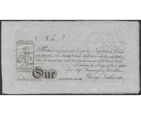
S.W.Fores No. 10, for Self, Fearnought & Hardblow, 1 Penny, 4 June 1818, promising to pay ‘the Emperor Napoleon or Bearer, one penny, when British Valour shall have been wholly subsided & when the French Army shall have become masters of the British Islands’, signed by George Lather’em and Bob Trimmer, with a vignette showing a map of the United Kingdom, labelled ‘Britannia, The Pride of the Sea, I’faith they are tight little Islands’, good extremely fine £100-£150 --- Another patriotic note, promising to pay Napoleon if he successfully invades. Originally printed at least a decade earlier, by 1818 it was a doubly safe bet, as Napoleon had been firmly defeated in 1815.

Lot 91
S.W.Fores No. 3, for Self, Leinster, Ulster, Munster & Connaught, 2 Pence, 1 January 1819, promising to pay ‘Rory O’Bogg Esqr or Bearer, when the Union of the Kingdoms shall have produced a union of Civil & Religious principles’, signed by Pat Potatoe and Dermot O’Wisky, with a vignette displaying a map of Ireland, about extremely fine £100-£150 --- This note is probably a comment on the ‘Act of Union 1801’, in which The United Kingdom and The Kingdom of Ireland were merged into one nation. While the news itself was slightly out of date by the time this reprint was created in 1819, the message that it might be difficult to truly unite such disparate ‘civil and religious principles’ remains relevant even to this day!

Lot 832
Bank of Goodluck, Jai Hind, a propaganda/political note denominated 1000 good wishes, c.1942, serial number AH/&C 10000, green and blue, Mother India (Bharat Mata) holding a flag and map of undivided India at left, Colonel Gubaksh SIngh Dhillon at right, large tear along central fold, tape repair, very fine and scarce Pick unlisted £100-£150

Lot 117
A Skit Note by an unknown printer for Self, Leinster, Ulster, Munster & Connaught, 2 Pence, 1 January 1803, promising to pay ‘Rory O’Bogg Esqr or Bearer, when the Union of the Kingdoms shall have produced a union of Civil & Religious principles’, signed by Pat Potatoe and Dermot O’Wisky, with a vignette displaying a map of Ireland, mounting traces, fine and a scarce original printing for this design £100-£150 --- This note is probably a comment on the ‘Act of Union 1801’, in which The United Kingdom and The Kingdom of Ireland were merged into one nation. It seems to suggest that whatever the official political situation, the union may be somewhat more difficult to manage!


Lot 1
BRAUN (GEORG) AND FRANZ HOGENBERG: Londinum Feracissimi Angliae Regni Metropolis C1575. Hand-coloured engraved map, title cartouche with border of roses and swags, Tudor Royal and City arms, Hand coloured (340 x 485mm), with Latin text to verso; mounted, framed and glazed.Condition ReportPlease see images for condition.


Lot 108
MSS & Indentures- Heacham Award; 1781 & 1854; commissioners appointed the act for 'dividing, allotting & enclosing'. Over 100pp, folio. Full vellum; Three indents on vellum. 1712, 1766 & 1869, & one other; Two indentures on vellum: Barsham Estate, Norfolk. 3PP + full page coloured map in each: Ref: Lady Katherine Ann Balder; Plus one other; King's Silver, roll 79, 1755; Plus 3 others. (qty.)Provenance: The Peter and Pat Crofts Collection

Lot 15
PHILLIPS, John, & W. F. HUTCHINGS: A Map of the County of Stafford Divided into Hundreds & Parishes, From an Accurate Survey, Made in the Years 1831 & 1832. Hand coloured, linen backed and folding, (1,370 × 990mm); with a view of Lichfield cathedral. In the original leather bound box/slipcase & cover. VG

Lot 174
SOLDINI, Francesco Maria; Gaetano Vascellini (Engraver): Il Reale Giardino di Boboli nella sua pianta e nelle sue statue. [Florence: 1789.]; 4to. (285 x 210mm). Engraved title page, large folding map of the gardens Plus 46 Plates, Later leather backed marbled boards, rubbed. Very clean copy.


Lot 207
AFRICA: STANLEY, H M: 1- In Darkest Africa.. in 2 vols. Sampson Low, 1890, 3rd. edn. Original pictorial cloth gilt; little rubbed & the folding map is loose & torn; 2- Through the Dark Continent, 2 vols. New York, Harper & Brothers, 1878; 3- Through the Dark Continent. Complete in one volume. 1890. Full tree calf prize binding; David Livingston: Missionary Travels and Researches in South Africa. Murray, 1857, 1st. edn. With maps & plates. Later cloth and new endpapers; damp staining to a couple of plates; Popular account of missionary travels.. 1861, 1st. Plus one other. (8) Provenance: The Peter and Pat Crofts Collection.

Lot 21
MAP: Davies's New Map of the British Metropolis the Boundaries of the Boroughs County Court Districts Railways and Modern Improvements. 1864. Large folding linen backed and hand coloured map in 32 sections (950 x 700mm). Original cloth binding gilt.Provenance: The Peter and Pat Crofts Collection

Lot 216
Whitby: Charlton, L: History of Whitby and Abbey, York, Ward, 1779 1st, edn, 4to, With a large folding plan plus 3 plates. Cont. half leather; rubbed; Young, G: History of Whitby & Streoneshalh Abbey, 2 vols. Whitby, 1817, 1st. Edn. With a folding map, 5 plates & folding Table. Cont. plain boards, rubbed & stained; Allison's picturesque pocket companion.. Whitby & its neighbourhood. Whitby, 1850, frontis & ill. Heavily annotated copy throughout; Plus one other. (5)Provenance: The Peter and Pat Crofts Collection

Lot 22
JOHNSTON, AK: Atlas to Alison's History of Europe. Blackwood, 1848. Oblong 4to. PP: Frontis, 16 (military & marine terms), large folding coloured linen backed map of Europe + 98 hand coloured maps of various battles, etc. Original half calf, recased with later endpapers. VGProvenance: The Peter and Pat Crofts Collection

Lot 225
IRISH Interest: BARROW, J: A Tour Round Ireland Through the Sea Coast Counties, in the Autumn of 1835. Complete with a large folding silk lined map plus 8. Cont. half leather; rubbed; browning/oxidisation to the title page & one plate; FLOWER, Robin: Eire and Other Poems. 1910, 1st. edn. Signed by author & dated 10-10-10; printed card covers; edges & spine chipped with some loss; THOMAS, RS: The Stones of the Field. The Druid Press, Carmarthen, 1946, 1st. edn. DW (6s), VG+; 15 Poems; Russian Red Cross. Socialist Party (Belfast) 1942, 1st. edn. Wrappers, VG; Poems by Thomas MacDonagh. Talbot Press, Dublin, 1st. edn. Wrappers; VG; Plus one other Dublin print. (6)Provenance: The Peter and Pat Crofts Collection

Lot 233
TRAVEL: BAKER, SW: Ismailïa, in 2 Vols. 1874, 1st. edn. Map & all plates present. Original pictorial cloth gilt; Stevens, T: Around the World on a Bicycle: From Tehran to Yokohama. 1888. Complete by itself (another volume was published: (From San Francisco to Teheran). Original pictorial cloth gilt, VG; Keate, G: An account of the Pelew Islands. 1803. With 20 of 21 plates? (one plate crossed out in the list). Full calf & later spine; Guillaume, H: The Amazon Provinces of Peru.. 1894, with a large folding map & 32 plates. Original cloth gilt; rubbed, map with tears to fold; Ishmael Bashaw: The Turkish Refugee. No date [1797]. 48pp. Later marbled boards, few small stains; Baines, T: The Gold Regions of South Eastern Africa. 1877, 1st. with 4 photographic plates and numerous illustrations, but lacking the folding map; Plus 6 others (13) Provenance: The Peter and Pat Crofts CollectionProvenance: The Peter and Pat Croft Collection
Lot 239
POLAR EXPLORATION: LYON, George Francis: The Private Journal of Captain G. F. Lyon, of H.M.S. Hecla, during the Recent Voyage of Discovery under Captain Parry. Murray, 1824, 1st. edn. With a large folding map & 7 plates. PP: xi, (i), 468. Near cont. speckled calf & later spine. The bookplate of John Havelock Fidler. Offsetting from the plates; o/w VGProvenance: The Peter and Pat Crofts Collection

Lot 241
PECK, Francis: Academia Tertia Anglicana; or, The Antiquarian Annals of Stanford in Lincoln, Rutland and Northamptonshire. In XIV Books. Printed for the author by James Bettenham, 1727, 1st. edn. Subscriber’s copy. Illustrated with a large folding map, 32 plates & 4 text engravings. Cont. full leather, rebacked, preserving the original spine; rubbed.Provenance: The Peter and Pat Crofts Collection

Lot 26
JRR TOLKIEN: Signed 1st. edns: The Lord of the Rings 1- The Fellowship of the Ring, Unwin, 1954, 2nd. impr. DW (21s.).DW with tears, tape repairs & stains; small cut to base of the spine. Folding map; 2- The Two Towers, Unwin, 1954, 1st. impr. DW (21s.). DW torn with small loss & lacking the spine; small spot to cover. Folding map; 3- The Return of the King, Unwin, 1955, 1st. impr. SIGNED by the author (The owner’s father was at Oxford the same time as Tolkien, met him and asked him to sign it). DW (21s.). DW with tears, small loss & tape repairs. (3)Condition ReportReturn of the king signed only. See images of dust wrappers. Very minor foxing to some pages. No water staining or damp.

Lot 268
EARLY PRINTING: NEVILLE, Alexander: De furoribus Norfolcensium Ketto Duce.eiusdem Norvicus. Henrici Binnemani, 1575, 1st. edn. First issue; 2 parts/vols in 1. Small 4tol. PP: (xiii), (iii) blank, 156; (xi), (i)b, 207, (xxvii), (i)b. Colophon dated 1576. With two title pages & the Arms of Archbishop Parker on verso of both title pages. Bound with: Apology to the Welsh. Later full calf, with earlier spine. VG [The first part comprises a contemporary history of Kett’s rebellion of 1549; and On p.32 there is the famous passage speaking of the laziness of the Welsh levies and comparing them to sheep, which at the insistence of an offended government was excised from later issues].Provenance: The Peter and Pat Crofts CollectionCondition ReportTwo pages are torn, one with a small hole, some foxing and discolouration, there is no map present.
![MILITARY: [Kane, General]: A System of Camp Discipline, Military Honours, Garrison-Duty, and other Regulations for the Land F](https://cdn.globalauctionplatform.com/77e1096b-5fc9-4299-bd4d-aee500f847b7/228b360e-3d49-4f4d-b01e-aee700f15eb6/468x382.jpg)
Lot 270
MILITARY: [Kane, General]: A System of Camp Discipline, Military Honours, Garrison-Duty, and other Regulations for the Land Forces, 1757, 2nd. edn. With a folding hand coloured map (torn with loss), 20 plates, some hand coloured (6 torn with small loss) & a folding table (torn with loss). Cont. full leather & later spine; Plus Six other military works, 1821-1929. (7)Provenance: The Peter and Pat Crofts Collection
Lot 276
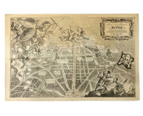
WHISTLER, Rex: Flying Visit of Truth to Berlin in the form of an R. A. F. leaflet raid here fancifully depicted - but not forgetting a great many hard facts, The Illustrated Magazine, Dec 9th, 1939, black and white satirical map of an aerial view of Berlin (520 x 325mm), Folded twice, small tears to the blank edges, no loss.Provenance: The Peter and Pat Crofts Collection

Lot 282
AMERICAN INTEREST: Catlin, G: 1- Letters & notes on the manners, customs & condition of the North American Indians, 2 vols. Printed for the author by Tilt & Bogue, 1842, with a folding map & numerous line drawings. Cont marbled boards 7 later cloth spine & endpapers; 2- Life amongst the Indians. Sampson Low, 1861, with 14 engravings. (3)Provenance: The Peter and Pat Crofts Collection

Lot 286
AMERICAN INTEREST: Burnary, A: Travels through the middle settlements in North America in 1759 & 60. Payne, 1775. Later plain boards & new endpapers; title page relaid, with small loss to top margin; last page torn, without loss; [Franklin, Benjamin, and Richard Jackson]: An Historical Review of the Constitution and Government of Pennsylvania.. London: R. Griffiths, 1759, 1st. edn. Cont. full mottled calf, recased with the original spine; [Jun, JC]: the United States and Canada as seen by two brothers in 1858 & 61. 1862, 1st. edn. With a folding coloured map (tears to folds). Original cloth, rubbed & cuts to spine; EMORY, WH: Notes of A Military Reconnoissance from Fort Leavenworth, in Missouri, to San Diego, In California. Washington, Wendell.. 1848, With 41 plates, LACKING THE FOLDING MAP; Act of Parliament for encouraging making of pott ashes & pearl ashes in the British plantations in America. 1751. PP: TP, 1107-1111, Plain boards; Plus 3 others. (8)Provenance: The Peter and Pat Crofts Collection
![[BLAEU, Joan]: MAP of Somersetshire- Somerset: Tensis Comitatus. | Somersetshire. (1648), Hand coloured (510 x 400mm); mounte](https://cdn.globalauctionplatform.com/77e1096b-5fc9-4299-bd4d-aee500f847b7/f1f72b51-c04d-47f1-bd77-aee700f10bbb/468x382.jpg)
Lot 3
[BLAEU, Joan]: MAP of Somersetshire- Somerset: Tensis Comitatus. | Somersetshire. (1648), Hand coloured (510 x 400mm); mounted, framed and glazed; Plus: Bowen, E: An Improved Map of the County of Somerset, Divided into its Hundreds, C1760, Hand coloured (510 x 400mm); mounted, framed and glazed. (2)

Lot 312
THE FENS: Miller (SH) & Skertchly (SBJ): THE FENLAND PAST AND PRESENT, FOLIO Edition. Wisbech, Leach & Son, 1878 1st. edn. PP: xxxii (including Subscribers’ list), 649. Folding map & 25 plates (one coloured). Half leather over marbled boards, marbled endpapers & top edges gilt. Covers little rubbed; map torn at fold (without loss); scattered spotting. Nice CopyProvenance: The Peter and Pat Crofts Collection


Lot 315
FENLAND, LINCOLNSHIRE, NORFOLK, ETC. Large quantity including: White’s Gazetteer & Directory of Lincolnshire, 1872, PP: 884, (ii), 78 (adverts). Later cloth & new endpapers, bound without the map; Rackham, A (ill): Sunrise Land, 1894; Thew, J: Report of an enquiry… corporation of King’s Lynn, Norfolk. Stamford, 1833, 1st; Wisbech Working Man’s club & Institute, 1884-95, 12 (years); The Gentlemen’s Society of Spalding, its origin & progress, 1851, 1st. Etc. (qty.)Provenance: The Peter and Pat Crofts Collection
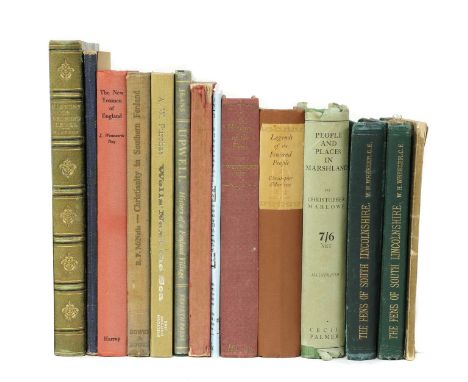
Lot 316
FEN History: 1- ELSTOBB, W: An Historical Account of the Great level of the Fens, Called Bedford Level, and other fens, marshes and low-lands. Lynn, W. Whittingham & sold by S. Crowder, 1793, 1st. edn. PP: viii, (xi) Subscribers list, (i) adv, 276, (4) adv.+ large folding Map. Later half leather, scattered spotting; one page with a tear and old repair; 2- Wheeler, WH: History of the Fens of south Lincolnshire. Boston, 1868, 1st. edn. The Author’s own copy, interleaved with his notes and corrections throughout. Original cloth; rubbed; the map with a tear; 3- Another copy; 4- Johnson, C: Account of the trial & execution of the Ely & Littleport rioters in 1816. Ely, 1893, 1st. PP: 77, (vii) adv.. Original wrappers; edges frayed; Plus Ten others. (14)Provenance: The Peter and Pat Crofts Collection

Lot 319
FENLAND Topography: Johnson, E (Photo): The Fen & Marshland churches, A series of Photographs.. 3 Vols. Wisbech, Leach, no date, c1869-76, With 47 photographic plates + 9 ground plans. Half leather; rubbed; Skertchley: Geology of the Fenland. 1877, 1st. 24 plates & maps; Miller & Skertchly: Fenland past & present. Wisbech, 1878, 1st; Heathcote: Reminiscences of Fen & Mere. 1876 1st. Plates & maps; Small stain to edges of few pages; Miller: Hand-book to the Fenland. 1890, new edn. folding Map; Clarke: Fen sketches. 1852, 1st. PLUS 9 others. (17)Provenance: The Peter and Pat Crofts Collection

Lot 321
MAPS (IRBY, Frederick, Baron Boston of Boston, Lincolnshire): LENNY, J: A unique collection of 9 Maps on Vellum, Drawn by J. Lenny, comprising of: Seas End farm, Moulton estate & Fens (3 maps); New Sea Bank to the Roman Bank; Roman Bank to the Turnpike; Turnpike to Austen Dike, Austen Dike to Chaper; Chaper to the Load Bank. Folio, each map with a small vignette and calligraphic dedication leaf, interleaved with paper. Original full red morocco gilt & lettered "Plans' ' to upper cover, which is detached.Provenance: The Peter and Pat Crofts Collection

Lot 322
MAPS/Marshland- Utting, J: 1- Plan of the survey & levels of the sewers, drains, bridges, tunnels & sluices in the parishes of the county of Marshland.. 1824, Very large (1,800mm wide), tears and some loss; 2- Plan of the levels taken in Marshland Smeeth & Fen, Norfolk, 1827. Hand coloured & rolled; PLUS: Hart, J C (Engineer):Map of an estate in Marshland, the property of Gustavus Helsham, 1894. Hand coloured, linen backed & rolled (2,850 x 1320mm). (3)Provenance: The Peter and Pat Crofts Collection
![NAVIGATION: 6 tracts Bound in One vol: 1- [kinderley, C]: Ancient & present state of the navigation of the towns of Lynn,](https://cdn.globalauctionplatform.com/77e1096b-5fc9-4299-bd4d-aee500f847b7/e1e7d8d8-8ac0-42da-9539-aef30117ac62/468x382.jpg)
Lot 323
NAVIGATION: 6 tracts Bound in One vol: 1- [kinderley, C]: Ancient & present state of the navigation of the towns of Lynn, Wisbech, Spalding & Boston, 1751, with a folding map; 2- The Claim of taxing the Navigations and free lands for the drainage ... of the Fens, 1793; 3- An Abstract of the Case and Opinions that have appeared in print for and against the Eau Brink Cut, 1794; 4- Observations upon some of the clauses of the bill.. For settling the draining of the ... Bedford Level, 1808; 5- Report of the joint committee of drainage & navigation.. No title page; 6- Letter to his Grace the Duke of Bedford, governor of the Bedford Level Corp.. On the works in the New Bedford.. The river Ouze.. 1828, with 3 folding Maps. Half leather, rubbed.Provenance: The Peter and Pat Crofts CollectionCondition ReportPlease see images for condition.


Lot 329
MAPS: Collection, including: 4 by Morden, Hand coloured Map of Huntingdonshire. Nd, c1640. (450 x 390mm); Hand coloured Map of Lincolnshire, c1695, (480 x 420mm); Map of Norfolk, nd, folded (600 x 400mm), edges frayed; Hand coloured Map of CAMBRIDGESHIRE. Abel Swal, nd; Plus: Walker: CAMBRIDGESHIRE. Hand coloured Map, 1837, Folding, (480 x 350mm); Moore: Map of The Great Level of the Fenns from a map of 1684. 1720, (410 x 300mm); Grundy: Ancient river Witham, 1743. (740 x 470mm); Plus 9 others. (qty.)Provenance: The Peter and Pat Crofts Collection
-
109182 item(s)/page