We found 109182 price guide item(s) matching your search
There are 109182 lots that match your search criteria. Subscribe now to get instant access to the full price guide service.
Click here to subscribe- List
- Grid
-
109182 item(s)/page


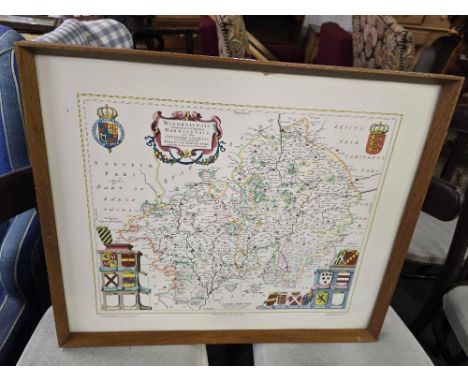

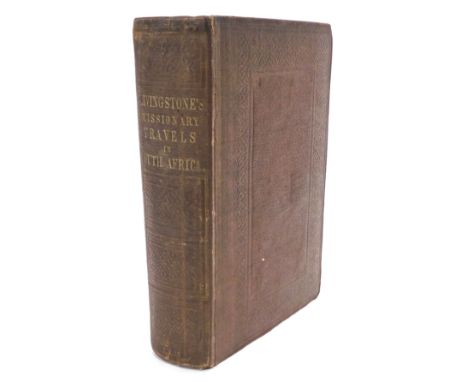
Lot 482
Livingstone (David). Missionary Travels and Researches in South Africa, first edition, inscribed by the author, folding engraved map, chromolithograph plates, bookplate of Thomas Adolphus Sitwell Drew, publishers cloth, 8vo, 1857, Inscribed 'Andrew Drew Esq. with kindest regards David Livingstone 30th April 1858'.

Lot 15
British Commonwealth Collection Primarily on Stockcards, plus odds in Stockbook. Good Selection seen throughout including Barbados KGVI 1950 set of 12 used , Gold Coast 1948 set Used , Falkland Isl Dep Map set used , Bermuda 2/- and 5/- 1938 Key Plate Val both used , Jamaica 1938 set used , New Zealand 1935 with better values noted , KUT 1954 with higher MM vals seen , British Solomon Isl 1966/67 set Used , &/ 1968/71, used, Malawi 1964/65 with higher vals seen Norfolk Ships 1967/68 used , Pitcairn 1964 used, Jamaica 1962 with top values used , Australia 1931 Kingsford Smith set M , Barbados 1935 SJ Set U , 1938 set U , Australia Robes HV U, Plus more odds seen of good value throughout , then a small Stockbook with a selection of Romania mainly mint with odd values 1869 - 1950s. Nice lot , Condition is varied in places but sorting will reward.


![[Lozano (Pedro)] A True & Particular Relation of the Dreadful Earthquake Which happen'd at Lima, the Capital of Peru and](https://cdn.globalauctionplatform.com/6c650054-78d6-40e0-ab2a-b11000c58a90/41d17801-065b-462a-9df5-b12b00e91844/468x382.jpg)
Lot 749
[Lozano (Pedro)] A True & Particular Relation of the Dreadful Earthquake Which happen'd at Lima, the Capital of Peru and the neighbouring Port of Callao on the 28th of October 1746, London: T. Osborne, 1748, engraved folding map, 8 folding plates, appendix and three pages of publisher's advertisements, contemporary calfNot collated. Binding and spine scuffed and scratched, hinges cracked but binding otherwise good, pastedowns a little foxed and toned with some thumbmarks to pages, otherwise a nice bright copy

Lot 681
Cook (Captain James) & King (Captain James) A Voyage to the Pacific Ocean undertaken by Command of his Majesty for Making Discoveries in the Northern Hemispheres … in the years 1776, 1777, 1778, 1779 and 1780 illustrated with cuts in four volumes, full tree calf, 4 Volumes, London: John Stockdale, Scatcherd and Whitaker, John Fielding and John Hardy, 1784, 8vo (4)Generally good condition overall, with a few issues. Consistent rubbing, bumping and general wear to boards consistent with age (particularly to the spines, where the lettering has been rubbed away). Tear to foldout map in volume 3. Plates appear to be in tact. Mild internal foxing throughout, with the endpapers particularly affected. Some slight tears to certain pages. The General Chart to volume 1 is essentially in tact, with wear around the edges and a small hole along one of the crease lines (with an accompanying tear and hole to the contents page that follows). Consistent foxing to page edges. Pages 369-

Lot 742
Harrington (Sarah) A New Introduction to the Knowledge and Use of Maps, London: S Crowder and J Walter, 1773, second edition, 12mo, full calf boards, fold-out engraved map with hand colouring.Not collated. Missing frontispiece; binding bears wear including scuffing and rubbing; internally, there is staining and foxing.
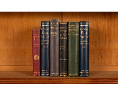
Lot 695
Hunting, 6 volumes, to include: Pottinger (Henry) Flood, Fell, and Forest, London: Edward Arnold, 1905, 2 vols, 8vo, original blue cloth gilt, bookplates for Henry Pottinger; Chapman (Abel) Retrospect, Reminiscences and Impressions of a Hunter-Naturalist in Three Continents 1851-1928, London: Gurney and Jackson, 1928, 8vo, original green cloth gilt, top edge gilt, numerous lithgraphic plates and engraved vignettes, errata to page xv; Mockler-Ferryman (A F) In the Northman's Land, London: Sampson Low, Marston & Company, 1896, 12mo, original pictorial cloth gilt, deckled page edges, fold-out map and numerous lithographic plates; Newall (Captain J T) Scottish Moors and Indian Jungles, London: Hurst and Blackett, 1889, 8vo, black cloth gilt, various lithographic plates; Melvill (T P) Ponies and Women, London: Jarrolds, 1932, 8vo, original cloth gilt. (6)Not collated. Shelf wear and foxing to all volumes. Pottinger: some shelf wear, including bumping to corners and wear to spines; foxing to page edges, with soiling to endpapers; some light foxing but contents fairly bright otherwise. Chapman: bumping to corners and general shelf wear; some soiling, foxing and warping to the inside, with pencil annotations in places. Mockler: rubbing and warping to binding; soiling to endpapers with pencil inscription; extensive spotting to endpapers.
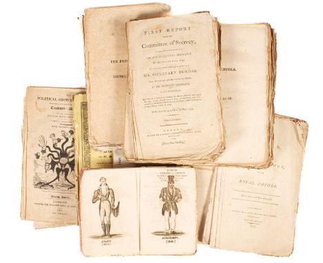
Lot 753
A collection of unbound ephemera publications predominantly George III and Regency to include Political Showman at home, twelfth edition, London: William Hone, 1821; Thoughts on the Prince's Debts, London: J. Debrett, 1795; A Letter to the Prince of Wales on second application to Parliament, London: J. Owen, 1787, 5th edition; A True Statement of the Circumstances which led to the late change of Administration, London: J. Ridgway, 1807; A short account of a late short administration, London: J. Ridgway, n.d.; 2nd Edition; Plain Facts or the new ministry convicted by their own deeds, London: J. Ridgway, 1807; Letters of Scaevola on the Dismissal of His Majesty's late ministers, Part 1 & 2, London: J. Ridgway, 1807; First & Second Report from the Committee of Secrecy, London: J. Debrett, 1794, third edition; Non Mi Ricrodo & c ..., London: William Hone, 1820, 22nd edition, George Cruikshank illus.; The Political House that Jack Built, London: William Hone, 1819, 15th edition; Sophia Princess of Zell to George the First on his accession to the Throne of England - A Poetical Epistle, London: William Hone, 1820; An Admonitory Letters to H.R.H. the Prince of Wales on the Subject of the Late Delicate Enquiry, London: Tipper & Richards, 1806, 7th edition; A Letter from a young Prince to his Royal Father, London: J. Owen, 1795; Communications on the Part of the Queen with his Majesty's Government laid before the Houses of Parliament, June 1820, London: G. Clarke, 1820, 4to.; An Act for enlarging the Terms and Powers granted ... for repairing the Roads from Henley Bridge ... to Dorchester Bridge, London, n.d.; Cappe (Newcombe) Four Discourses on the Incompatibility of the Love of Pleasure with the love of God, York: Printed by Thomas Wilson, 1820; Phillips (Richard) Golden Rules for Jurymen, single sheet, 57cm x 45cm; Bradshaw's Map of the Railways, n.d. 40cm x 53cm, single sheet; and three French publications including Ambs-Dales (J.B.), Histoire Veritable et Complete de Chodruc-Duclos, surnomme L'Homme aux Haillons et la Longue Barbe..., Paris, 180, Quatrieme Edition, 12mo

Lot 821
Map of Oxfordshire, published by the Oxford Geographical Institute, William Stanford & Company, 1904, the map separated into two parts, measuring 158cm x 146.5cm overall, folded, in blue cardboard caseSome clear wear to the map, including foxing and other signs of wear. Some fading, discolouration and scuffing to the case.
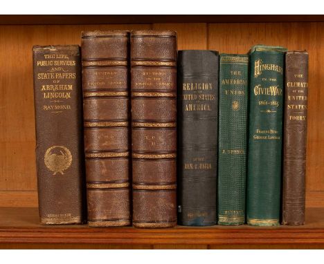
Lot 719
American Interest, to include: MacKay, Charles The History of the United States of America, London: Virtue & Co, 2 vols, 4to, half calf boards with raised bands to spine, marbled end papers and page edges, engraved frontis and half title, numerous engraved plates, fold-out map and fold-out engraved facsimile of the signatures of the Declaration of Independence; Baird (Robert) Religion of the United States of America, Glasgow and Edinburgh: Blackie and Son, 1844, 8vo, embossed cloth boards with gilt lettering to spine, fold-out map to frontis; Burr (Fearing) and Lincoln (George) The Town of Hingham in the Late Civil War, Hingham and Boston: Rand, Avery & Co, 1876, 8vo, original embossed cloth gilt; Forry (Samuel) The Climate of the United States and its Endemic Influences, New York: Langley, 1842, 8vo, embossed decorative cloth with gilt lettering to spine; Raymond (Henry J) The Life and Public Services of Abraham Lincoln, New York: Derby and Miller, 1865, 8vo, embossed decorative cloth with gilt lettering to spine, bookplate for John Stafford Reid Byers; Spence (James) The American Union, London: Richard Bentley, 1862, 8vo, embossed green cloth with gilt lettering to spine. (7)Not collated. McKay: some general shelf wear, including rubbing and bumping to bindings, as well as areas of staining to boards; internally, there is some foxing, with more prominent areas of staining in places, especially to the engravings. Baird: some shelf wear, including rubbing and bumping to boards; moderate foxing internally, as well as pencil inscription to first page. Hingham: some shelf wear, including rubbing and bumping to binding, as well as foxing internally. Forry: general shelf wear, including rubbing and bumping to binding, as well as extensive foxing and soiling, especially around end papers; there are also pencil and ink inscriptions to the first pages. Raymond: volume generally in fairly poor condition, with extensive foxing and soiling and newspaper clipping glued inside; damage to binding, including bumping and tearing around the spine. Spence: volume bears general shelf wear, including bumping, as well as some internal foxing and tearing.

Lot 823
Lazard-Trefous Environs de Paris, Map printed on Toiles and inscribed: Chez Lazard-Trefous, M.d de Cartes Geographiiques Imprimees sur Toiles, Rue aux Ours, No. 6, A Paris 1829, within an associated card wrapper with the bookplate for Strickland Freeman Esq., Fawley Court, Bucks, 1810, 89cm x 61cm


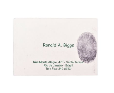
Lot 421
The Great Train Robbery - Ronnie Biggs (1929-2013) - an original personal business card from Biggs, as given out whilst he lived in Rio De Janeiro. The card features text ' Ronald A Biggs ' alongside Biggs' fingerprint (printed). The rear of the card features a map and arrow pointing to Biggs' address. 6cm x 9cm. The Great Train Robbery was the robbery of £2.6 million from a Royal Mail train heading from Glasgow to London on the West Coast Main Line in the early hours of 8 August 1963, at Bridego Railway Bridge, Ledburn, near Mentmore in Buckinghamshire, England. After tampering with the lineside signals in order to bring the train to a halt, a gang of fifteen, led by Bruce Reynolds, attacked the train. Other gang members included Gordon Goody, Buster Edwards, Charlie Wilson, Roy James, John Daly, Danny Pembroke, Jimmy White, Ronnie Biggs, Tommy Wisbey, Jim Hussey, Bob Welch and Roger Cordrey, as well as three men known only as numbers "1", "2" and "3". A 16th man, an unnamed retired train driver, was also present. With careful planning based on inside information from an individual known as "The Ulsterman" (erroneously named as Patrick McKenna in 2014), the robbers escaped with over £2.6 million (equivalent to £53.5 million today). The bulk of the stolen money was never recovered. Though the gang did not use any firearms, Jack Mills, the train driver, was beaten over the head with a metal bar. Mills' injuries were severe enough to end his career. After the robbery, the gang hid at Leatherslade Farm and famously used the money in a game of Monopoly - unwittingly incriminating themselves whilst doing so as the Monopoly set was used to garner finger prints of the suspects and was instrumental in the Police arresting most of the gang. The ringleaders were sentenced to 30 years in jail.


Lot 28
WWI Interest - a collection of First World War effects relating to 2330 Rifleman H. Lister of the 12th Battalion Rifle Brigade - including a twelve-page handwritten diary detailing some of his service, including details of his enlistment, training, a particularly gruelling encounter which Germans in which he was shot through the hand. Also included is a framed photograph of Lister (believed) and two related family photographs of a First World War soldier, a framed display featuring a 'report of gallant conduct' '...for continuously carrying messages under heavy rifle and shell fire near Guillemont,' and a later WW2 Home Guard certificate for the 'good service rendered.' A handwritten poem believed to have been written by Lister is also included, possibly for his Brother, that ends 'God Bless you Bertie and bring you back in peace and safety, 3.9.14 'H''. A period paper WW1 map ' The German Offensive Of The Somme 1918' is also included.

Lot 490
Original vintage propaganda poster depicting World War Two Allied Air Offensive against Germany up to January 1st 1941. An aerial bombing map of Northern Germany with an enlarged inset of The Ruhr. The Key features information on Munition Works Power Stations / Aerodromes or Seaplane Bases / Aircraft Works / Oil / Railways / Docks & Waterways / German Navy / More than one type of objective bombed. Printed for H.M. Stationery Office by J. Weiner, Ltd. London, UK. 76 x 50.5cm.


Lot 120
A modern silver State of Qatar presentation cigarette box, engraved with map of Qatar, depictions of buildings and life in Qatar and with applied gilt spandrels; rosewood lining, Grant MacDonald Silversmiths (George Grant MacDonald), London 1989, 20cm wide, in gilt-tooled leather presentation case


![GUEUDEVILLE, Nicolas].- Le grand theatre historique, ou nouvelle histoire universelle, tant sacrée que profane, depuis la cre](https://cdn.globalauctionplatform.com/c52a4a5e-b615-45ad-8196-b11800fa666b/56dbbc3b-d8ff-4d75-aa28-b12300d59627/468x382.jpg)
Lot 177
GUEUDEVILLE, Nicolas].- Le grand theatre historique, ou nouvelle histoire universelle, tant sacrée que profane, depuis la creation du Monde, jusqu’au commencement du XVIII siecle. Contenant una fifidéle & exacte description de ce qui s'est passé de plus memorable sous les quatre premières Monarchies, des Assyriens, des Perses, des Grecs, & des Romains, comme aussi des Monarchies qui leur ont succedé, et ce qui concerne commement le peuple Juif, & qui se trouve dans la Sainte Écriture & ailleurs, avec la suite de l'Histoire Romaine...- A Leide: Chez Pierre Vander Aa, 1703.- 5 tomos. em 2 vols.: il.; 36 cm.- E. I - [34], 544 col. em [272] p.; II - [4], 742 col. em [371] p.; III - [4], 478 col. em [239] p.; IV - [4], 620 col. em [310] p.; V - [4], 770 col. em 385 p., 152 p., Monumental edition, profusely illustrated, published without the author's name, usually attributed to the French Benedictine translator and historian Nicolas de Gueudeville (1652-1721). The five volumes include the following copperplate prints: dedication to King Frederick William of Prussia (double), an allegorical title, a world map (double), 2 double prints and 10 portraits printed separately, more than 650 illustrations integrated into the text (±110x145 mm). Copy with slight browning, light handling and occasional stains; World map with tears in the folds, without lack of support. Contemporary bindings, entirely made of burnished sheepskin, a little worn, with loose joints, preserving the original marbled paper endpapers. Brunet, II, coll. 1699. Graesse, III, p. 184.


Lot 529
A SELECTION OF DECORATIVE PRINTS ETC, to include an unframed Glyn Thomas etching 'King's Gateway' 23/200, approximate size 31cm x 22cm including margins, four unframe indistinctly signed etching of Venetian scenes including the Ducal Palazzo approximate size 50cm x 36cm, a 1720 map of the Parish of St Martins, indistinctly signed etchings of Prague, eight framed prints of wading birds, topographical prints, mirror etc. (Qty)


Lot 25
Registration - TGC 397L Chassis No. - 3440961 M.O.T. - Exempt Odometer - 26,306 According to howmanyleft.co.uk there are just 15 examples of BMW’s 2002 Touring registered in the UK today, making ‘TGC 397L’ a rather rare motor car. This RHD model rolled off the Munich production line in 1972 and was imported into the UK in 1983. Presented in original and eye-catching Golf yellow paintwork, this three-door hatchback has received certain modifications to give it a sportier look, performance and feel. The 2-litre engine has been fitted with new Weber Twin 40 carburettors, and the car has been lowered 50mm with Alpina-style wheels and equipped with an Alpina-style front spoiler. The vendor describes the engine, four-speed manual transmission, electrics, paintwork and highly original black vinyl interior as ‘good’. With the huge membership and event calendar of BMW Car Club GB, the new owner of ‘TGC 397L’ will have unending opportunities to show it off amongst like-minded enthusiasts. BMW produced its 02 series of two-door compact, sporty cars from 1966 to 1975. The 02 series evolved from the Neue Klasse (New Class) four-door executive saloons, the BMW 1500, 2000 C and 2000CS, which had returned the company to solvency after it found itself in dire financial straits in the 1950s. 25cm shorter, and faster, lighter and more affordable than its big ‘sisters’, the first 02 Series model, the 1.6-litre 1600-2 (later known as the 1602), found a ready audience, not least because it also handled better than its more luxurious and larger siblings. In 1968 BMW brought out the 2-litre 2002, and with it a new era began for the company, as its reputation for a producer of affordable but high-quality performance cars was established. The 02 Series was produced in saloon, convertible, targa and hatchback (Touring) models and all found an enthusiastic audience – and had an appeal which lasts to this day. The 2002 in its various guises was produced from 1968 to 1974 and, in 1975, the 02 series was replaced with 3 Series, apart from the 1502, which continued in production until 1977. But by 1975 the 02 Series had already done its job, rescuing BMW from the prospect of financial disaster and reputational obscurity, and putting it firmly on the map and well on the way to being viewed as ‘The Ultimate Driving Machine’. In summary: · One of just 15 2002 Touring models believed to be registered in the UK today (source: howmanyleft.co.uk) · An unusual, practical and highly collectable classic · Upgraded with Weber Twin 40 carburettors, Alpina-style wheels and an Alpina-style front spoiler

Lot 158
Rarely offered single volume from Hetzel's French edition Aux Bouquets de Roses avec Encadrement de Grecques, 4eme type, rouge ancien cover, from Les Voyages Extraordinaires by Jules Verne. Includes the novel De La Terre a La Lune (From the Earth to the Moon) with 41 illustrations and one map by De Montaut. Collection Hetzel, Bibliotheque d'Education et de Recreation, published by Pierre Jules Hetzel et Cie, Paris. On recto of front cover, Ex Libris Docteur et Madame Camplez. Artist: Jules Verne (French 1828-1905)Issued: 1873Dimensions: 7.50"W x 11"H x 0.60"DManufacturer: HetzelCountry of Origin: FranceCondition: Very good. Minor wear on covers. Foxing throughout.

Lot 144
Handsome single volume of Hetzel's French edition A La Banniere (Bicolore au Ballon) argentee, green cover, from the Voyages Extraordinaires series by Jules Verne. Includes the novel Mathias Sandorf with 111 illustrations by Leon Benett and one map. Catalogue CR for the years 1885-1886. Collection Hetzel, Bibliotheque d'Education et de Recreation, published by Pierre Jules Hetzel et Cie, Paris. Artist: Jules Verne (French 1828-1905)Issued: 1885Dimensions: 7.50"W x 11"H x 1.75"DManufacturer: HetzelCountry of Origin: FranceCondition: Very good. Minor foxing. Superficial color loss on covers and gilding. Small tear on upper right side of spine.

Lot 143
First edition double volume of Hetzel's A La Banniere (Bicolore au Ballon), type 2, Havane cover with green banner, from the Voyages Extraordinaires series by Jules Verne. Includes the novels De La Terre a La Lune (From the Earth to the Moon) with 41 illustrations and one map by De Montaut and Autour de la Lune (Around the Moon) with 44 illustrations by Emile Bayard et A. de Neuville. Catalogue for the years 1875-1876. Collection Hetzel, Bibliotheque d'Education et de Recreation, published by Pierre Jules Hetzel et Cie, Paris. Artist: Jules Verne (French 1828-1905)Issued: 1875Dimensions: 7.50"W x 11"H x 1.75"DEdition Number: First edition Manufacturer: HetzelCountry of Origin: FranceCondition: Fair. Some discoloration on spine and corner wear. Soiling and foxing. Beginning of separation between front cover and first page.

Lot 146
First edition double volume of Hetzel's A La Banniere (Bicolore au Ballon), type 2, blue cover, from the Voyages Extraordinaires series by Jules Verne. Includes the novels De La Terre a La Lune (From the Earth to the Moon) with 41 illustrations and one map by De Montaut and Autour de la Lune (Around the Moon) with 44 illustrations by Emile Bayard et A. de Neuville. Catalogue for the years 1875-1876. Collection Hetzel, Bibliotheque d'Education et de Recreation, published by Pierre Jules Hetzel et Cie, Paris. Artist: Jules Verne (French 1828-1905)Issued: 1875Dimensions: 7.50"W x 11"H x 1.75"DEdition Number: First edition Manufacturer: HetzelCountry of Origin: FranceCondition: Fair. Discoloration on front cover and spine. Small cartonnage rip on central back spine. Some soiling on back cover. Worn corners. Foxing throughout.

Lot 163
Single volume from Collection Hetzel's A Un Elephant (le titre dans la cartouche) from the Voyages Extraordinaires series by Jules Verne. published by Librairie Hachette et Co, Paris. Includes the novel Mathias Sandorf with 111 illustrations by Leon Benett and one map. Artist: Jules Verne (French 1828-1905)Issued: c. 1920Dimensions: 7.50"W x 11"H x 1.75"DCountry of Origin: FranceCondition: Fair. Beginning of tear on upper spine. Weakening of spine cover. Soiling on back cover. Gild loss. Corners wear. Clean interior with browning of pages.


Lot 500
David Shepherd (1931 - 2017), herd of elephants, colour print on board, 50 x 100cm, framed, Bailleul, Aquarelles, Pastels et Huiles, Honfleur poster, 63 x 42cm and another similar, David Shepherd (1931 - 2017), elephant, colour print, 23 x 29cm, framed and glazed and a map of Wiltshire, featuring Stonehenge, 37 x 49cm, framed and glazed

Lot 1027
Gage, John: The History and Antiquities of Suffolk, Thingoe Hundred, Published By John Deck, Bury St Edmunds, and Samuel Bentley, Dorset Street, 1838, thick 4to, 1st edition, hand-coloured engraved map, numerous plates, plans and illustrations (Hengrave Porch and Harvey portrait photocopies), re-bound in half blue morocco over cloth boards, with handwritten note regarding restoration on Ixworth Abbey headed paper dated February 1982 (see images), Royal 4to. (1)
-
109182 item(s)/page