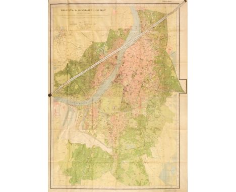

India. Gunter (Col. C. P. publisher), Calcutta & Howrah Guide Map, published at the Survey of India Offices, Calcutta, 1926, colour folding lithographic map, laid on linen on a scale of 4 inches to the mile, retaining the distance tape indicator, very slight dust soiling and creasing, 1160 x 800 mm, bound in the publisher's blue cloth gilt boards, boards slightly spotted, envelope recess to the verso of the front board containing a 32-page alphabetical list of names, together with Burrard (Colonel Sir S. G.). Guide Map of Simla, the Survey of India Offices, Dehra Dun, 1917, colour lithographic map, sectionalised and laid on linen, inset map of Jutogh, 700 x 925 mm, contemporary printed title label with manuscript ownership signature to the upper cover QTY: (2)
We found 109182 price guide item(s) matching your search
There are 109182 lots that match your search criteria. Subscribe now to get instant access to the full price guide service.
Click here to subscribe- List
- Grid
-
109182 item(s)/page
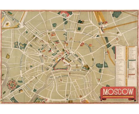
Intourist (publishers). Three Soviet pictorial city and regional plans, Moscow a Map by Michael Getmanski, Pictorial Map Panorama of Leningrad [and] Pictorial Map of the Caucasus, published Moscow, 1935 - 38, together, three colour lithographic folding maps with explanatory text in English, the map of Moscow with small areas of repair where old folds cross and backed with archival tissue, the map of the Caucusus with very short splits where old folds cross and retaining the publisher's pictorial boards, the map of Leningrad with short splits where old folds cross and short closed tears along a few old folds, the map retains the rear paper wrapper with a contemporary manuscript ownership signature, the upper wrapper is detached, 580 x 845 mm, 350 x 670 mm and 415 x 590 mm respectivelyQTY: (3)NOTE:Intourist was the official Soviet agency for tourism and was established in 1929. Decorative and aesthetically well-designed maps; they are clearly aimed at English speaking tourists. This is somewhat counter-intuitive as Britain did not establish formal relations with Russia until 1929 and the U.S.A. would not do so until 1933 - 34. This was also the period of Stalin's first five-year plan, the Great Depression was still affecting the world economy and the Soviet Union was a remote and difficult place to reach. It is something of a mystery why these maps were published in English and who the Soviets thought would use them.
![Ireland. Mercator (Gerard), Ultoniae Orientalis pars [1595 or later], hand-coloured engraved map, central fold strengthened a](https://cdn.globalauctionplatform.com/21b22f34-a274-4e72-bd63-aea600d93d9e/2d335f93-28f4-4d6b-af89-aea6010292ee/468x382.jpg)
Ireland. Mercator (Gerard), Ultoniae Orientalis pars [1595 or later], hand-coloured engraved map, central fold strengthened and repaired on verso, some marginal closed tears, one small stain affecting the printed image, 350 x 380 mm, Latin text on verso, together with Bertius (Petrus). Lagenia [1616], engraved miniature map with sparse wash colouring to the Irish Sea, 95 x 135 mm, Latin text on verso, mounted, with Hondius (Jodocus). Udrone, circa 1606, hand-coloured engraved map, slight staining, largely confined to the margins, 135 x 175 mm, Franch text on verso, plus Van den Keere (Pieter). Connack, circa 1627, hand-coloured miniature map, 90 x 120 mm, English text on versoQTY: (4)
![Italy. Mortier (Pierre), Bergamo Ville des Venitiens dans le Bergamasque...., Amsterdam [1700 - 24], uncoloured engraved city](https://cdn.globalauctionplatform.com/21b22f34-a274-4e72-bd63-aea600d93d9e/1f3be1eb-3857-4396-9df1-aea6010293a4/468x382.jpg)
Italy. Mortier (Pierre), Bergamo Ville des Venitiens dans le Bergamasque...., Amsterdam [1700 - 24], uncoloured engraved city plan, 16 point key plan to the lower right, old folds, trimmed within platemark bottom left for binding purposes, slight spotting, occasional marginal closed tears, 445 x 605 mm, together with Jaillot (Alexis Hubert). Carte Particuliere des Pays qui sont Situez entre le Rhein, la Sarre, la Moselle, et la Basse Alsace..., circa 1700, large engraved map with contemporary outline colouring, on six conjoined sheets, laid on later linen, old folds, some marginal fraying, slight dust soiling, 1395 x 1020 mmQTY: (1)NOTE:The old folds on the first described item would indicate that this example is possibly from a later edition of Blaeu's town book, published by R.C. Alberts in 1724.

Japan. Blaeu (Johannes), Japonia Regnum, Amsterdam, circa 1655, engraved map with contemporary outline colouring, some staining, largely confined to the margins, 420 x 565 mm, mounted, framed and glazedQTY: (1)NOTE:This was to remain the standard form of Japan until the eighteenth century and although replaced by the maps of Reland and Kaempfer, it is in its outline, closer to the true shape of Japan than either of these or indeed any printed map before the nineteenth century. It was compiled by Father Martino Martini, an Italian Jesuit, and appears in Blaeu's Atlas Sinensis, the first European atlas of China. It is the first map to correctly show Korea as a peninsula.

Japan. Briet (Philippe), Royaume du Japon designé par le Pere Ph: Briet, de la Compagnie de Jesus. Sur les memoires des Peres de la mesme Compagnie, Paris Pierre Mariette, circa 1660. engraved map with faint contemporary outline colouring, slight staining, 380 x 530 mm, mounted, framed and glazed QTY: (1)NOTE:The engraver, Jan van Somer, worked for Sanson in Paris. Sansom published composite atlases comprised of maps primarily by Mariette and Sanson, and this may be the source for this particular map. This appears to be the second state of the map with the addition of the four cardinal points along the graticule.

Japan. Seutter (George Matthaus), Imperium Japonicum per Sexaginta et Sex Regiones Digestum atque ex Ipsorum Japonensium Mappis Descriptum, Augsburg, circa 1750, engraved map with contemporary outline colouring, inset map of the vicinity of Nagasaki, slight toning, some tape staining to the margins, horizontal margins trimmed, 490 x 580 mm, mounted, framed and glazedQTY: (1)NOTE:Matthaus Seutter's later edition of Adrien Reland's seminal map of Japan. Reland's map was highly unusual in that it used Sino-Japanese characters on a European printed map, sourcing his material from Japanese maps, rather than European examples.


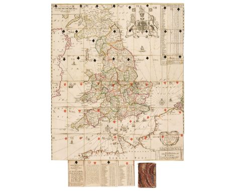
Lenthall (John, publisher). Geographical Cards of England, with part of Scotland and Ireland, and the adjacent parts of France and Flanders, describ’d to tabulate upon the Ace of Harts and the Ace of Diamonds, London: printed for and sold by John Lenthall, [circa 1712-1717], the complete deck of 52 playing cards, the 4 aces with printed description, directions, and list of counties, the remaining cards formed from an engraved map of England and Wales, hand-coloured in outline and dissected into 48 cards, each card with stencilled suit sign in black or red, the 48 map cards with ink manuscript number or Queen / King / Knave, ace of hearts with red ink tax stamp, plain versos, some light spotting, and minor marks, occasional light offsetting, 2 cards with very slight adhesion scarring, each card 95 x 58mm, with contemporary sleeve, formed from (presumably waste) playing cards of plain design, stitched together and covered in marbled paper, rubbed with some minor wearQTY: (1)NOTE:Mann, All Cards on the Table, p.132 (illustration); Mann, Collecting Playing Cards, p.140 (no. XII); Wowk, p.96.Campbell, Tony. “Chronicle for 1991.” Imago Mundi, vol. 44, 1992, p. 140: 'The Geographical cards of England, John Lenthall [c.1718-44], (40 of 52 cards, each composed of a section of the map of England engraved by James Moxon). Sotheby's 14 November 1991 [Lot]...210'.This extremely scarce pack of early geographical playing cards was created from a map of Britain engraved by James Moxon, itself based on an earlier version by Adais. When Moxon died in 1708, John Lenthall obtained many of the plates Moxon had engraved and reissued them. In this case he reprinted Moxon’s map to be cut into a set of playing cards, with suit signs and numbers added by hand. In All Cards on the Table, Sylvia Mann suggests a date of c.1700 for these cards, which could have been true for earlier copies without a tax stamp. However, in his IPCS journal supplement Taxation on Playing-Cards in England... John Berry concludes that the 'crown' tax stamp, when unnumbered (as here), was used for packs made after August 1712 but before January 1718.

London. Gill (MacDonald), The Wonderground Map of London Town, published The Westminster Press, circa 1924, photolithographic colour printed map, sectionalised and laid on linen, slight fraying to margins, a few sheets 'lifting' away from the linen backing, slight creasing, 740 x 930 mm, with part of a larger-scale example on the versoQTY: (1)NOTE:This is an example of the slightly smaller and later edition of Gill's original 1913 map. This is a 1924 edition which is assumed to have been altered to help the promotion of the 1924 British Empire Exhibition that was held at Wembley between April and October of that year. It can be identified by a sign saying:- 'On To Wembley' and an empire lion in the top left-hand corner below the man pushing a bus. The map remains highly stylised and whimsical and was held in great affection by Londoners. It was originally commissioned by The London Underground and was designed to be displayed in tube stations. The intense pictorial content of the map caught the public's imagination and as a result, Gill is often credited with creating a resurgence of the genre of decorative map making. Much work and research has been done by Roderick Barron and Bryars & Bryars on the maps of the Underground and the work of Macdonald Gill and I am also grateful to Claire Dobbins book, London Underground Maps: Art, Design and Cartography.
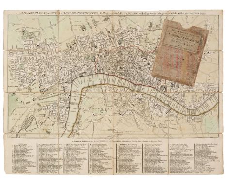
London. Kitchin (Thomas), A Pocket Plan of the Cities of London & Westminster & Borough of Southwark including everything remarkable to the present Year, 1st Feby. 1773, engraved map with contemporary outline colouring, sectionalised and laid on linen, table of reference below the map, one long split along old linen fold, 380 x 500 mm, contained in a contemporary marbled card slipcase with publisher's printed label to the upper cover, slight wear to the extremitiesQTY: (1)NOTE:James Howgego. Printed Maps of London, number 159, state 1.
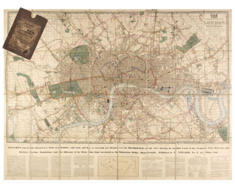
London. Laurie (Richard Holmes, publisher), Laurie's New Plan of London and its Environs, with an Improved Scale for Ascertaining Distances..., by John Lingard No. 3 Maria Lane, London, being an Original Survey by John Outhett, with all the recent Improvements, 1846, engraved map with contemporary outline colouring, sectionalised and laid on linen, new title pasted over old printing, additional title - "Lingard's Superb and Enlarged New Map of London with Scale and Key to ascertain any Distance over the Metropolis...," and explanatory text below the map, very slight staining, cloth endpapers, 820 x 1090 mm, contained in a contemporary cloth slipcase with a printed label to upper cover, worn and a little bumped, together with three mid-19th century Ordnance Survey maps of Staffordshire, Nottinghamshire and South Yorkshire, two with contemporary outline colouring, all contained in contemporary morocco slipcases and bindings, various sizes, good conditionQTY: (4)NOTE:The first described item. James Howgego. Printed Maps of London, no. 361, state 7.
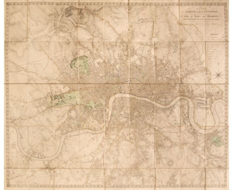
London. Lewis (Samuel). A Plan of London and its Environs Shewing the Boundaries of the Cities of London and Westminster, Metropolitan Boroughs and Parishes and Distances in Miles & Quarters of the Principal Roads from the General Post Office, circa 1850, engraved map by J.Dower, original outline colouring, sectionalised and laid on linen, calligraphic title, table of explanation and compass rose, a little dust-soiled, 940 x 1110 mm, contemporary morocco gilt board (lacking the upper board), frayed and worn QTY: (1)NOTE:James Howgego. Printed Maps of London 1553 - 1850, 373a, state 2.
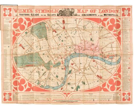
London. Wilme (B. P. W. surveyor). Wilme's Symbolic Map of London. or, Visitors Guide to the Sights and Amusements of the Metropolis, Baily Brothers, May 14th 1851, colour lithographic map, sectionalised and laid on linen, the map surrounded by panels of explanatory text, 550 x 710 mm, bound in contemporary cloth boards with an orange and black title label to the upper siding, ink manuscript ownership signature to the label, binding size 150 x 105 mmQTY: (1)

Maps. A collection of 11 maps, 18th & 19th century, engraved and lithographic maps, including Bowen (Emanuel). A New and Accurate Map of the East India Islands, laid down according to the latest discoveries...., circa 1750, hand-coloured engraved map, long printer's fold, central fold partially strengthened on the verso, 350 x 430 mm, together with Kitchin (Thomas). Mexico or New Sapin in which the motions of Cortes may be traced..., 1777, hand-coloured engraved map, inset map of the environs of Mexico, old folds, 290 x 385 mm, with Coronelli (Vicenzo Maria). Le Bermude..., circa 1690, hand-coloured engraved map, trimmed to the printed image along the lower margin (trimmed from a larger four map sheet), 230 x 305 mm, mounted, plus Cruchley (G. F.). United States with Upper & Lower Canada, Syria, India, Persia Arabia Cabool Afghanistan &c., Australia New Zealand East India Islands &c. &c. [and] China, together six lithographic maps with contemporary hand colouring, each approximately 460 x 355 mm, and Cook (James, publisher). Sketch of the Typa and Macao, circa 1785, uncoloured engraved map, toned overall, 340 x 225 mm, with River Thames and Mercury Bay in New Zealand, Bay of Islands in New Zealand [and] Tolaga Bay in New Zealand, circa 1780, three hand-coloured engraved maps on one sheet (as published), originally published in Hawksworth's 'An Account of the Voyages..., in the Southern Hemisphere', old folds, tape staining in the margins, 290 x 440 mmQTY: (11)

Maps. A collection of 5 maps, 17th & 18th century, including Merian (Matthaus). Amsterdam, circa 1650, hand-coloured engraved city plan, slight mount staining, 275 x 360 mm, together with Dapper (Oliver). Paskaert vande Caspise Zee, circa 1670, hand-coloured engraved map of the Caspian Sea, laid on later limp card, 295 x 355 mm, with Senex (John). The VII United provinces Corrected from the Observations Communicated to the Royal Society at London..., circa 1720, large engraved map with contemporary outline colouring on two conjoined sheets, occasional marginal closed tears and slight fraying to the upper border, 660 x 940 mm, plus Moll (Herman). A Chart of the Baltick or East Sea. Gulf of Finland &c. circa 1740, hand-coloured engraved map, old folds, 290 x 345 mm, and Bowen (Emanuel). A New and Accurate Map of Poland, Lithuania &c. Divided into its Palatinats..., circa 1750, hand-coloured engraved map, old folds, 350 x 435 mmQTY: (5)
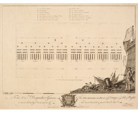
Military Maps. A collection of four maps and plans, 18th century, including Menageot (Augustin). To the Honble. Brigadier Guise, This Geometrical plan of ye Camp in ye Isle of Wight, is most Humbly Dedicated by his most Humble & most Obedt. Servts., A.Menageot & Chrisr. Seton, March 16th. 1741, uncoloured engraved plan with a large ornate military cartouche, 355 x 465 mm, together with Brönner (Heinrich Ludwig, publisher). Carte de Guerre de L'armée Alliée de S. M. La Reine de Hongrie sous le Comandementy de sa Majesté le Roy de la Grande Bretagne George II et de Armée du Roy de France Comandé par le Duc de Noailles sure le Maein, circa 1743, uncoloured engraved plan of the Battle of Dettingham, with explanatory text (in English and in French) separately printed and pasted to the vertical margins, old folds, occasional repaired marginal closed tears, backed with archival tissue, 390 x 700 mm, with Mazell (P.). A Plan of Southampton and the Polygon, 1771, uncoloured engraved plan with an inset map of the 'Intended Polygon', this was a 22-acre site based around a twelve-sided polygon comprising of houses, hotels, assembly rooms and taverns - similar to the Royal Crescent in Bath - but the investors went bankrupt and the project stalled and the enterprise ultimately failed, toned overall, slight creasing, vertical margins frayed and creased, 460 x 630 mm, plus an unattributed watercolour plan of he Seige of Gibraltar circa 1727, old 'drawing pin' holes to the corners, slight toning, 225 x 280 mmQTY: (4)NOTE:The first described item: Ashley Baynton Williams, British Broadsheet Maps and Battle Plans. Catalogue 2008, item 27. The young 13-year-old James Wolfe (later General and victor of Quebec in 1759) was present with his father Edward at this camp, from which he wrote home to his mother on 6th August describing the embarkation of troops for Cartagena (letter printed in Wood, 1915. p.5) The second item was the last battle in which a reigning British monarch (George II) led his troops into combat.

Northern Counties. A collection of approximately 45 maps, 17th - 19th century, engraved and lithographic county and regional maps and town & city plans of Durham, Cumberland, Westmorland, Cheshire, Yorkshire and Lancashire including Blaeu (Johannes). Episcopatus Dunelmensis vulgo The Bishoprike of Durham [and] Westmoria comitatus Anglice Westmorland, Amsterdam, circa 1648, together two engraved maps with contemporary outline colouring, each approximately 380 x 500 mm, Latin text on verso, together with Morden (Robert). Westmorland [and] Episcopatus Dunelmensis vulgo The Bisoprick of Durham, 2 copies of each [1695 or later], together 4 hand-coloured engraved maps, each approximately 370 x 420 mm, with Saxton (Christopher & Hole G). Eboracensis comitatus..., vulgo East Riding [1610], hand-coloured engraved map, 200 x 250 mm, plus Saxton (Christopher & Kip W.). Westmorlandiae comitatus qui olim Spectaunt ad Brigantas [1637], hand-coloured engraved map, 265 x 310 mm, and Smith (C.). A New Map of the County of Durham..., A New Map of the County of Westmorland..., [and] A New Map of the County of Cumberland..., 2nd edition, 1808, together 3 engraved maps with contemporary outline-colouring, each approximately 445 x 485 mm, with Collins (H. G.). Cumberland, Westmorland, Northumberland [and] Lancashire, circa 1850, together 4 hand-coloured engraved map, each approximately 425 x 355 mm, and Meisner (Daniel). Corvus non Albescit, Carlile in Anglia [1638], uncoloured engraved city plan with a figure in the foreground pouring a watering can on three Ravens, illustrating the Latin title 'Corvus non Albescit' - a Raven doesn't whiten, 105 x 150 mm, with another 30 maps, including examples by or after Ellis, Cole & Roper, Duncan, Reuben Ramble, Bowen, Archer, Cary, Dawson, Whittaker, Bartholomew, Moll, Neele, Moule, A. E. Taylor and Stockdale, various sizes and conditionQTY: (approx. 45)
![Northumberland. Speed (John), Northumberland, John Sudbury & George Humble [1611 or later], uncoloured engraved map, inse](https://cdn.globalauctionplatform.com/21b22f34-a274-4e72-bd63-aea600d93d9e/9af11e82-0a7f-435a-b7d0-aea60102a25f/468x382.jpg)
Northumberland. Speed (John), Northumberland, John Sudbury & George Humble [1611 or later], uncoloured engraved map, inset town plans of Berwick and Newcastle, some creasing, light overall toning, slight staining, occasional marginal closed tears, margins strengthened on the verso, 385 x 505 mm, no text on verso, together with Bowen (Emanuel). An Accurate Map of the County of Norfolk Divided into its Hundreds...., Robert Sayer, John Bennett, J & C Bowles, 1777, uncoloured engraved map, toned overall, slight mount staining, 415 x 500 mm QTY: (2)

Poland. Von Pufendorf (Samuel), Auctior et Correctior Tabula Chorographica Regni Poloniae Vicinarumque Regionum ubiitinera quae Seren Rex Sueciae Carolus Gustavus...., Nuremberg [1696], hand-coloured engraved map, engraved by L. Cordier and decorated with numerous heraldic crests, 290 x 380 mm, displayed in a double-aperture mount with an uncoloured facsimile of the same mapQTY: (1)

Prussia. Visscher (Nicolaus), Magnae Prussiae Ducatus Tabula..., Petrus Schenk Junior, Amsterdam, circa 1750, engraved map with contemporary outline colouring, 440 x 530 mm, together with Funck (David). Magnae Prussiae Ducatus Tabula denuo correct et in lucem edita..., Nuremberg, circa 1696, scarce uncoloured reticulated map, engraved by Johann Joachim Puschel, faint old folds, 470 x 555 mm, with Dépòt Général de la Guerre (publisher). Carte du Royaume de Prusse et de la Partie Septentrionale du Grand Duche de Varsovie au Depot Generale de la Guerre..., Paris, 1808, engraved map of Northern Poland with contemporary outline colouring, sectionalised and laid on linen, issued immediately after the signing of the treaty of Tilsit, slight spotting, 590 x 790 mm, plus Ortelius (Abraham). Prussiae Descrip. circa 1585, uncoloured engraved miniature map, small crease to the upper right corner, 75 x 105 mm, mounted, framed and glazed and Gibson (J.). Prussia [1792], uncoloured engraved miniature map, 65 x 95 mm, supplied with a page of contemporary explanatory textQTY: (5)

Sayer (J. P.). 12 Original Lithographic Prints Comprising the First Twelve up to October 1947, of the Series of Picture Maps of London..., first published in the Strand Magazine, George Newnes Ltd. circa 1948, twelve colour lithographic pictorial maps of districts within London, each with an illustrated description to the verso, publisher's printed paper wrappers, binding size 200 x 280 mm, together with another copy with an additional map of Whitehall bound at the rear (making 13 maps on total), retaining the publisher's paper wrappers but bound in near-contemporary burgundy morocco with a gilt title 'London' to the upper cover, slight staining to the rear boardQTY: (2)
![Scotland. Pont (Timothy / Blaeu Johannes), Coila Provincia, The Province of Kyle [and] Caricta Borealis vulgo The North part](https://cdn.globalauctionplatform.com/21b22f34-a274-4e72-bd63-aea600d93d9e/b6e7e7d1-913a-4232-999a-aea60102a9b2/468x382.jpg)
Scotland. Pont (Timothy / Blaeu Johannes), Coila Provincia, The Province of Kyle [and] Caricta Borealis vulgo The North part of Carrick, Amsterdam, circa 1654, two engraved maps with contemporary outline colouring, central folds strengthened and repaired on verso, each approximately 455 x 570 mm, Coila with Spanish text on verso, Carrick with no text on verso, together with Von Reilly (Franz Johann Joseph). Die Orcadischen Inseln [1789], engraved map with contemporary outline colouring, 215 x 340 mm, plus Dawson (Lieut. R. E.). Kirkwall [ 1832], engraved town plan with contemporary outline colouring, 280 x 225 mmQTY: (4)
![Shetland Islands. Van Keulen (Gerard), Het Eyland Hitland met zyn Onderhoorige Eylanden, Amsterdam [1728], uncoloured engrave](https://cdn.globalauctionplatform.com/21b22f34-a274-4e72-bd63-aea600d93d9e/53f26c38-9265-418f-9a7e-aea60102ab1b/468x382.jpg)

Silesia. Hondius (Henricus), Comitatus Glatz Authore Jona Sculteto, Amsterdam, circa 1640, engraved map with contemporary outline colouring, orientated to the west, very slight staining, 385 x 465 mm, French text on verso, together with Homann (Johann Baptist, heirs of). La Compte de Glatz avec le Principaute de Munsterberg..., Nuremberg, 1747, engraved map with contemporary outline colouring and some later enhancement, slight staining largely confined to the margin, occasional marginal repaired closed tears, slight creasing, 490 x 560 mm, with Seidel (Gotthold E. F.). Charte von der Grafschaft Glatz..., Homann's heirs, Nuremberg, 1806, map with contemporary outline colouring, engraved by Christian M. Trummer, slight browning to central fold, central fold strengthened on verso, left-hand vertical margin extended, 545 x 485 mm, with two other maps of Glatz by or after Mercator/Jansson and Le Rouge, various sizes, good conditionQTY: (5)NOTE:Glatz was - until 1945 - a Prussian district in Silesia, its capital being the town of Glatz. It is now part of the Polish Lower Silesian Voivodeship.

Sleigh (Bernard). An Anciente Mappe of Fairyland Newly Discovered and Set Forth, published Sidgwick and Jackson, printed Vincent Brookes Day & Son, circa 1925, a large pictorial colour lithographic map laid on linen, very slight creasing, occasional marginal repaired closed tears with associated tape staining, 480 x 1800 mmQTY: (1)NOTE:A large fantasy map of Fairyland by the Birmingham born artist Bernard Sleigh (1872 - 1954).

Somerset. Blaeu (Johannes), Somersettensis comitatus Somerset Shire, Amsterdam, circa 1645, engraved map with contemporary outline colouring, some damp staining to the lower margin, some repaired closed tears and creasing, slight mount staining, 385 x 495 mm, Dutch text on verso, together with Rapkin (J.). Clifton and Bristol, John Tallis & Company, circa 1850, decorative hand-coloured engraved city plan, 360 x 485 mm, with Van den Keere (Pieter). Somersetshire, circa 1627, hand-coloured engraved map, some marginal tape staining, 85 x 120 mm, English text on verso, plus Seller (John & Grose Francis). Somersetshire, circa 1787, hand-coloured engraved map with English text below and on the verso, map size 125 x 150 mmQTY: (4)
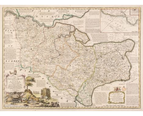
South-East England. A collection of 10 maps, 17th - 19th century, engraved maps of Kent, Essex, Buckinghamshire, Sussex and Suffolk, including Bowen (Emanuel). An Accurate Map of the County of Kent Divided into its Lathes, and Subdivided into Hundreds..., J. Tinney, 1753, engraved map with contemporary outline colouring and some later enhancement, originally published in 'The Large English Atlas', inset map of the Downs, old folds, one repaired closed tear affecting the printed image, 530 x 710 mm, together with An Accurate Map of the County of Essex, Divided into Hundreds; Drawn from Surveys..., Robert Wilkinson, Bowles & Carver and Laurie & Whittle, circa 1762, engraved map with contemporary outline colouring and some later enhancement, originally published in 'The Royal English Atlas', slight staining to the central fold, 410 x 495 mm, with Saxton (Christopher & Kip William). Sussexia sive Southsex olim pars Regnorum, circa 1637, hand-coloured engraved map, large strapwork cartouche, mileage scale and compass rose, 225 x 390 mm, plus Blome (Richard). A Mapp of Buckinghamshire with its Hundreds, circa 1673, hand-coloured engraved map, 320 x 260 mm, and Blaeu (Johannes). Regiones Inundatae in sinibus Comitatus Norfolciae, Suffolciae, Cantabrigiae, Huntingtoniae, Northamptoniae et Lincolniae, Amsterdam, circa 1648, engraved map with contemporary outline colouring, slight creasing, 440 x 540 mm, Latin text on verso, with Bowen (Thomas). Suffolk Divided into Hundreds, Exhibiting the County, Borough and Market Towns..., T. Kitchin [1765 - 77], engraved map with contemporary outline colouring, originally published in 'The Atlas Anglicanus', 225 x 330 mm, with another four maps similar, including examples by Greenwood, Kirby and Butters, various sizes and conditionQTY: (10)
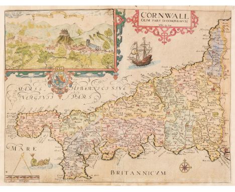
Southern Counties. A collection of four maps, 17th & 19th century, including Saxton (Christopher & Kip William). Cornwall olim pars Danmoniorum, circa 1637, hand-coloured engraved map, inset prospect of Launceston, central fold repaired and strengthened on the verso, trimmed to the neatline with three margins extended, slight fraying to the upper margin, 300 x 390 mm, together with Bowen (Emanuel). An Accurate Map of Hartfordshire Divided into Hundreds..., R. Sayer, J. Ryall, T. & J. Bowles, Bakewell & Parker, H. Overton and T. Kitchin, circa 1790. engraved map with contemporary outline colouring and some later enhancement, slight mount staining, 415 x 505 mm, with Bickham (George). Glocestershire [and] Wiltshire, [Laurie & Whittle, 1796], two engraved 'bird's-eye view' maps, Wiltshire coloured, Gloucestershire uncoloured, each approximately 235 x 155 mm, QTY: (4)
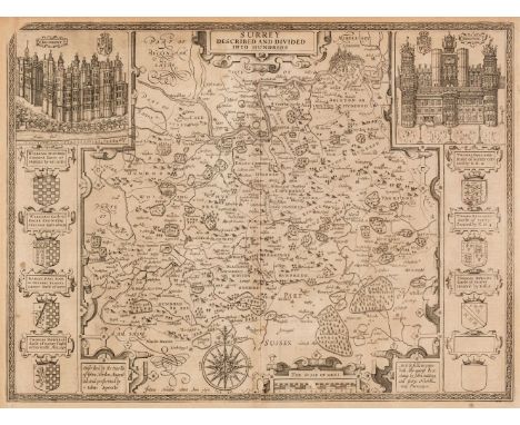
Surrey. Speed (John), Surrey Described and Divided into Hundreds, John Sudbury & George Humble, circa 1627, uncoloured engraved map, inset views of Richmond and Nonsuch palaces, very slight spotting, light overall toning, upper right corner with repaired closed tear, central fold strengthened on verso, 385 x 515 mm, English text on verso, together with Morden (Robert). Surrey [1695 or later], hand-coloured engraved map, slight mount staining, one short repaired closed marginal tear, 355 x 420 mm. with Greenwood C. & J.). Map of the County of Surrey from an Actual Survey made in the years 1822 & 1823, Greenwood & Co. July 4th 1829, engraved map with contemporary hand-colouring, calligraphic cartouche, compass rose, tables of reference and explanation, uncoloured oval vignette of Lambeth Palace & Church, slight offsetting, 570 x 680 mmQTY: (3)
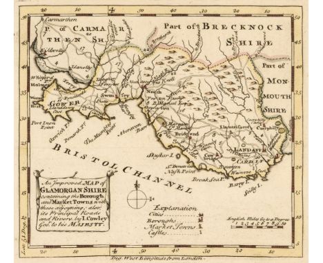
Wales. Cowley (John). Ten Welsh County Maps, Montgomery, Pembroke, Merioneth, Glamorgan, Flint, Denbigh, Cardigan, Carnarvon, Carmarthen [and] Monmouth, Robert Dodsley, circa 1744, ten engraved county maps, seven with later hand-colouring, old folds, each approximately 140 x 160 mm, mounted, together with Bill (John). Brecknockshire, [1624], uncoloured engraved map, one small repaired rust hole, 90 x 125 mm, English text on verso, mounted, with Taylor (Thomas). A Mapp of ye County of Monmouth with its Hundreds [and] Flintshire/Denbighshire, circa 1718, two engraved maps with contemporary outline colouring, originally published in 'The Principality of Wales Exactly Described', each approximately 175 x 250 mm, plus Dix (Thomas). A New Map of North Wales divided into its Six Counties or Shires, William Darton, June 13th. 1820, engraved map with contemporary outline colouring, sectionalised and laid on linen, large inset view of Snowdon, slight staining, small holes where the old folds cross, marbled endpapers, juvenile ownership signatures to verso, 540 x 695 mm, and Stanford (Edward, publisher). A Map of England & Wales Divided into Counties, Parliamentary Divisions & Dioceses shewing the Principal Roads, Railways, Rivers & Canals..., circa 1845, large folding map with contemporary outline colouring sectionalised and laid on linen on four separate sheets, engraved by J. Dower after R. Creighton, calligraphic title, uncoloured vignette view of the General Post Office London, some staining, finger and dust soiling, marbled endpapers, the whole approx. 2120 x 1760 mmQTY: (18)

Wales. Gibson (John), Set of 12 Welsh County Maps, circa 1759, twelve engraved miniature maps with contemporary outline colouring, originally published in 'New and Accurate Maps of the Counties of England and Wales', slight marginal toning and finger soiling, each approximately 650 x 115 mm, together with Bowles (Carington). Set of 12 Welsh County Maps, circa 1785, twelve uncoloured engraved maps (on 10 sheets), these appear to be examples from 'Bowles's Pocket Atlas of the Counties of South Britain', but lack the attribution title above each map, possibly from a later publication, each map approximately 125 x 190 mm, with Van den Keere (Pieter). Radnor, Breknok, Cardigan et Caermarden Descript, Johannes Blaeu [1617], uncoloured engraved miniature map, 90 x 125 mm, Latin text on verso, plus Wallis (James). The set of Twelve Welsh County Maps, originally published in 'The Panorama or Traveller's Instructive Guide', circa 1820, twelve engraved maps with contemporary hand-colouring, bound with a page of descriptive text for each county and a separate engraved title 'Welch Counties', contemporary gilt calf, boards detached and lacking spine, 12moQTY: (24)
![Wales. Ortelius (Abraham & Lhuyd Humphrey), Cambriae Typus Auctore Humfredo Lhuydo Denbigiense Cambrobritano, [1606], han](https://cdn.globalauctionplatform.com/21b22f34-a274-4e72-bd63-aea600d93d9e/13c08707-83f2-4d1a-97fd-aea60102b215/468x382.jpg)
Wales. Ortelius (Abraham & Lhuyd Humphrey), Cambriae Typus Auctore Humfredo Lhuydo Denbigiense Cambrobritano, [1606], hand-coloured engraved map, large strapwork cartouche, some dust soiling to margins, central fold strengthened and repaired on verso, 370 x 500 mm, English text on versoQTY: (1)NOTE:Marcel van den Broecke, Ortelius Atlas Maps, no. 21 (State 1). John Booth. The Antique Maps of Wales, no. 2.
![Wales. Speed (John), Montgomery Shire, Thomas Bassett & Richard Chiswell [1676], hand-coloured engraved map, inset plan o](https://cdn.globalauctionplatform.com/21b22f34-a274-4e72-bd63-aea600d93d9e/db33dc23-ddf1-4678-a800-aea60102b2e6/468x382.jpg)
Wales. Speed (John), Montgomery Shire, Thomas Bassett & Richard Chiswell [1676], hand-coloured engraved map, inset plan of Montgomery, large strapwork cartouche and compass rose, slight overall toning, occasional marginal closed tears, 385 x 515 mm, English text on verso, together with Blaeu (Johannes). Glamorganensis Comitatus vulgo Glamorgan Shire, Amsterdam, circa 1658, engraved map with contemporary hand-colouring, toned overall, slight dust soiling, 385 x 510 mm, Latin text on verso, with Kitchin (Thomas). An Accurate Map of Cardigan Shire drawn from an Actual Survey..., An Accurate Map of Brecknockshire Drawn from an Actual Survey..., [and] An Accurate Map of Carmarthenshire Drawn from an Actual Survey..., circa 1765, together three engraved maps with contemporary outline colouring and some later enhancement to the cartouches, originally published in 'The Large English Atlas', one horizontal margin extended on each map (where separated), each approximately 355 x 530 mmQTY: (5)
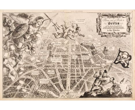
Whistler (Rex). Flying Visit of Truth to Berlin in the form of an R. A. F. leaflet raid here fancifully depicted - but not forgetting a great many hard facts, The Illustrated Magazine, December 9th, 1939, black and white satirical map of an aerial view of Berlin, some marginal closed tears strengthened on verso, very slight marginal spotting but not affecting the printed image, with descriptive text "What the R. A. F. sees over Berlin" on the verso, 325 x 485 mmQTY: (1)NOTE:The map commemorates the first British "nickel" (propaganda leaflet raid) over Berlin during World war II. It took place in early October 1939 and was carried out by planes of RAF10 Squadron. The raid was promoted as a sign of Germany's weak air defences and its vulnerability to attack. The R. A. F. is represented by numerous putti wearing flying helmets and goggles and being led by a warlike Britannia. In the lower right corner are caricatures of Hitler, Goebbels and Goering, shaking impotent fists at the sky whilst Von Ribbentrop cowers beneath a table. They support a 'skull and crossbones' flag with the skull wearing an SS cap. Rex Whistler joined the army in 1939 but was killed in action in 1944 in Normandy at the age of 39.
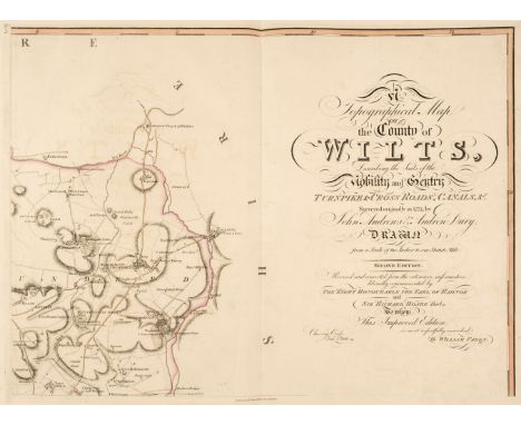
Wiltshire. Andrews (John & Dury Andrew), A Topographical Map of the County of Wilts, Describing the Seats of the Nobility and Gentry, Turnpike and Cross Roads, Canals, &c., Surveyed Originally in 1773..., 2nd ed., revised and corrected, published W. Faden, 1810, calligraphic title page, table of the market towns and villages, double-page engraved general index map and eighteen (complete) double-page engraved map sheets, all with contemporary outline colouring, slight offsetting and slight staining to the margins, later endpapers, bookplates of A. D. Passmore and Rev. Edward Duke (1779-1852, of Lake House, Wilsford cum Lake, Salisbury, Wiltshire, antiquary, archaeologist and a colleague of Sir Richard Colt Hoare), modern half calf gilt over marbled boards, folioQTY: (1)NOTE:The second edition of this map complete with the index map is considered scarce, with only five institutional copies recorded by Copac.

Wiltshire. Jansson (Jan), Wiltonia sive comitatus Wiltoniensis Anglis Wilshire, Amsterdam, circa 1648, engraved map with contemporary outline colouring, slight staining, central fold strengthened on verso, 400 x 500 mm, Latin text on verso, together with Morden (Robert). hand-coloured engraved map, old folds, occasional marginal closed tears, slight creasing, 345 x 410 mm, with Cary (John). A Map of Wiltshire from the Best Authorities, circa 1815, hand-coloured engraved map, old folds, slight spotting, but largely confined to the margins, 515 x 410 mm, plus Bowen (Emanuel). Wiltshire Divided into its Hundreds...circa 1760, uncoloured engraved map, old folds, 175 x 200 mm, and An Improved Map of Wilt Shire Divided into its Hundreds..., circa 1765, engraved map with contemporary outline colouring, old watercolour oxidised, some marginal closed tears, some affecting the printed image, upper margin trimmed to the neatline, some spotting and staining, 530 x 690 mmQTY: (5)
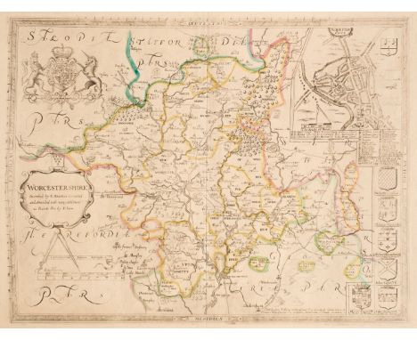
Worcestershire. Saxton (Christopher & Lea Philip), Worcestershire Described by C. Saxton, Corrected and Amended with many Additions as Roads &c. by P. Lea, George Willdey at the Great Toy Spectacle, China ware & Print Shop, circa 1720, engraved map with contemporary outline colouring, inset town plan of Worcester, strapwork cartouche and mileage scale, large margins, near-contemporary ink manuscript title on verso, 375 x 495 mmQTY: (1)
Vivien de Saint Martin (Louis). Atlas Universal pour servir à L'Etude de la Géographie et de l'Histoire Anciennes et Modernes, Paris, 1834, calligraphic title, 47 uncoloured maps comprising 34 single-page, 12 double-page and a four sheet map of France, table of contents bound at the rear, occasional marginal closed tears, some water staining, later endpapers, near-contemporary half calf gilt over later marbled boards, folio QTY: (1)
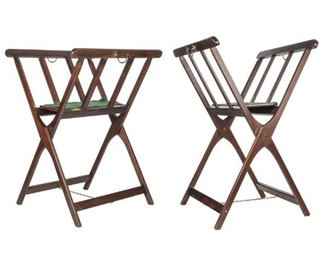
Print Stands. Two stained Beech Print or Map folio stands, mid 20th century, two stained and hinged folio stands, central supporting 'seat' lined with green felt (worn) with later hinges, each with two brass carrying handles and restraining chains, slight wear to extremities, height 860 mm, width (when open) 530 mm, length 650 mmQTY: (2)
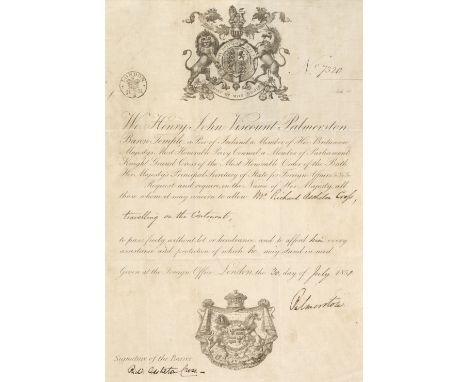
Cross (Richard Assheton, 1823-1914, 1st Viscount Cross). A group of 39 almanac pocket book diaries for 1840, 1854, 1856-61, 1863, 1864, 1867, 1869-73, 1875-82, 1884, 1885, 1887, 1889, 1892, 1896-1900 & 1906-10, all with brief notes, names, accounts, etc., and including 12 with notes of stays at Balmoral and Osborne with the Queen in 1875, 1877-79, 1884, 1885, 1887, 1889, 1896-98 & 1900, all original limp morocco wallet-stlye binding, occasional wear, volumes for 1854, 1856, 1857 & 1864 disbound, all 16mo, plus 2 octavo diaries with more substantial entries for 1842 & 1843, plus 3 wallet-style diaries for Cross's father William Cross (1771-1827), for the years 1823, 1826 & 1827, plus Richard Cross's passport, dated 30 July 1851, signed by Lord Palmerston, on linenised paper, folded in limp leather wallet-style binding with Cross's name stamped in gilt, plus a map of Preston where Cross served as MP, folded in wallet-style limp leather binding, plus a small memorandum book with a few notes and sketches, mostly in pencil, plus a pair of wooden castanets with green and yellow silk ties (partly broken), contained in a purpose-made red morocco case with tongue, the inner lid with gilt stamp 'Miss Ann Chaffers. Liverpool' [sister of Ellen Chaffers (1783-1849), wife of William Cross and mother of Richard Cross]QTY: (48)NOTE:Provenance: From the family of Richard Cross by direct descent.
![Bible [English]. The Bible: Translated according to the Ebrew and Greeke, and conferred with the best Translations in divers](https://cdn.globalauctionplatform.com/21b22f34-a274-4e72-bd63-aea600d93d9e/e97351b3-bbff-414d-88dd-aea60102fe32/468x382.jpg)
Bible [English]. The Bible: Translated according to the Ebrew and Greeke, and conferred with the best Translations in divers Languages..., Imprinted at London by Robert Barker, 1614, general title and New Testament titles present (NT title dated 1613), both with decorative woodcut borders, black-letter text in double-column, few woodcut decorative initials, red-ruled borders, with The Genealogies Recorded in the Sacred Scriptures... by J[ohn] S[peed] bound-in after first preliminary of Bible and before first leaf of Genesis (genealogies in woodcut, without map), bound without Apocrypha, bound with an incomplete Common Prayer and Psalms at rear, margins close-trimmed throughout volume with some shaving at head & foot, some toning and occasional light dust-soiling, 19th century marbled endpapers with armorial bookplate to upper pastedown bearing the motto 'virtus tutissima cassis', 19th century calf over bevelled wooden boards, worn and boards detached, 4toQTY: (1)NOTE:Herbert 330; Darlow & Moule 256; STC 2232. Geneva version.This particular volume of the Bible has been bound without the Apocrypha. Leaf F1 & F2 of the Bible is slightly torn to the upper outer corners with some slight loss to the running title. There is also a closed tear to 2C1. The text block is close-trimmed at head and foot with occasional loss/shaving to running titles, signatures & catchwords.
![Bible [English]. The Bible, containing the Old Testament, and the New. Newly Translated out of the Original Tongues and with](https://cdn.globalauctionplatform.com/21b22f34-a274-4e72-bd63-aea600d93d9e/f6d0ed2b-f7f1-4b02-ae33-aea601030047/468x382.jpg)
Bible [English]. The Bible, containing the Old Testament, and the New. Newly Translated out of the Original Tongues and with the Former Translations Diligently Compared and Revised, by his Maiesties Special Commandement, Imprinted at London: by Robert Barker, 1614 (i.e. 1615), general title and New Testament title within decorative woodcut borderst, Apocrypha present, double-column black letter text, New Testament title imprint and colophon dated 1615, short worm trail to upper outer corners of 22 leaves of New Testament, bound with at rear Two right profitable and fruitfull Concordances, or large and ample tables alphabeticall..., collected by R.F.H., Imprinted at London by Robert Barker, 1615, black letter text, bound with The Whole Booke of Psalmes. Collected into English Meeter, by Thomas Sternhold, John Hopkins, and others..., London: Company of Stationers, 1617, some damp staining to Concordance and Psalms, bound with at front The Genealogies by John Speed, defective with title & following leaf torn with loss (second leaf also lined to recto obscuring Adam & Eve woodcut), without map, and also bound with an incomplete Common Prayer at front (lacking title), final leaf of Common Prayer with genealogical manuscript entry 'Thomas Willis sonne of John Willis was baptised ... 21 daie of Februerye anno dom 1577 [&] Anne Eliz ... was baptised the 8 dai of December 1573' and also with later (18th/early 19th century) signature of a Miss Evelina Croft, occasional close trimming to few letterpress marginal notes within volume, some browning and light dust-soiling throughout, early 19th century endpapers (front free endpaper discarded) with ownership signatures of Caroline and Evelina Croft and with rebinding inscription dated 1811, also bearing an old Worthing public library stamp, early 19th century calf, red morocco title label to spine, joints a little cracked and light wear to extremities, covers rubbed and scuffed, 4to (21.5 x 16cm)QTY: (1)NOTE:Herbert 339. This edition with the omission of the word ‘Holy’ in the general title and both titles omit the words ‘Appointed...’. The text ends on Sss8a. With Ruth iii 15 ‘she’.
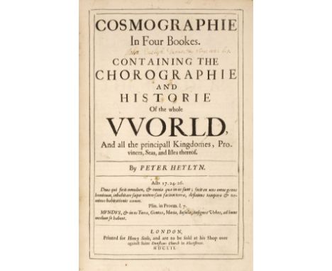
Heylyn (Peter). Cosmographie, In Four Bookes. Containing the Chorographie and Historie of the Whole World, and all the principal Kingdomes, Provinces, Seas, and Isles thereof, 1st edition, 2 volumes, London: Henry Seile, 1652, additional engraved title to first volume (small hole to upper blank margin, dust-soiled, lined to verso), initial titles to both volumes with signature of "John Evelyn [Junior] Durate &c Virg: aen: 1.1", four double-page engraved maps (Europe, Asia, Africa, and Americas), each map cropped to edges with some loss, first volume with ink stain to fore-edge blank margins of leaves 2Q1 & 2Q2 and closed tear to 2Q6, lower outer blank corner of 2S4 torn away, front free endpapers with manuscript press mark D6:8, front pastedowns with armorial bookplate of Sir Frederick Evelyn Bart. and 20th century John Evelyn library 'J.E' bookplate, attractive contemporary speckled calf, with elaborate gilt decorated spines, upper joint of first volume cracked at head & foot, folioQTY: (2)NOTE:Provenance: John Evelyn, junior (1655-1699), son of John Evelyn, writer, diarist & gardener, 1620-1706; The Evelyn Library, Christie's December 1, 1977, lot 740, where purchased by Desmond Burgess for £200.Wing H1689; ESTC R5447.Books 1-3, the two parts of book 4, and the Appendix each have separate dated title page; register attempts to be continuous. Pagination is separate except for book 4, part 2, which is continuous with part 1.

Xenophon. Xenoph?ntos Kurou paideias biblia okt?. Xenophontis de Cyri institutione libri octo. Graeca recognovit, cum codice MS. Oxoniensi & omnibus fere? libris Editis contulit, plurimis in locis emendavit, Versionem Latinam reformavit, Observationibus suis, Tabulaque Geographica auxit & illustravit ; Notas H. Stephani, Leunclavii, AE. Porti & Mureti recensitas & castigatas, Variantium Lectionum delectum, Indicesque necessarios adjunxit Thomas Hutchinson A.M., London: Typis J. Bettenham, impensis B. Barker & A. Bettesworth, 1730, engraved map frontispiece, first line of title in Greek characters, title page in red & black, Greek and Latin text throughout, front free endpaper with contemporary inscription Jon. Hodgetts Eins liber Anno Domini 1744 April the 28th' and bookplate of J.H. Hodgetts Foley to upper pastedown, contemporary calf, joints cracked, worn to spine and without title label, board corners worn and showing, 8voQTY: (1)NOTE:John Hodgetts-Foley (17 July 1797 – 13 November 1861) of Prestwood House (then in Kingswinford, and now in Kinver) in Staffordshire. He was the second son of the Hon. Edward Foley of Stoke Edith, Herefordshire and Eliza Maria Foley Hodgetts. He inherited the Prestwood estate from his mother, whose mother Eliza Foley was a descendant of the ironmaster Philip Foley (1648-1716). John represented the borough of Droitwich in Parliament from 1822 to 1835 as a Whig and East Worcestershire from 1847 to 1861 (initially as a Whig and from 1859 as a Liberal). He married Charlotte Margaret Gage, daughter of John Gage and Mary Milbanke (granddaughter of General Thomas Gage and Margaret Kemble), on 20 October 1825 and had one son, Henry John Wentworth Hodgetts-Foley.
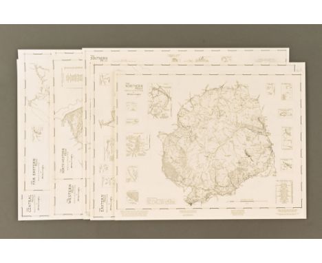
A set of seven maps of The Lakeland Fells, based on material contained in the Pictorial Guide to The Lakeland Fells by A Wainwright, titles "The Southern Fells", "The Western Fells", "The Eastern Fells", "Eastern Fells", "The Far Eastern Fells", "The Central Fells", "The Northern Fells", "The North Western Fells". Each map is an amalgamation of all his hand drawn pictorial maps for each of his geographical districts. All unframed, varying sizes. Provenance - These first edition maps were produced by Chop McKean Limited for Michael Joseph Limited throughout the mid to late 1990's. This collection then passed to Derek Walker a well known book wholesaler who was responsible for much of the success of the book sales for the Westmorland Gazette, this collection was then obtained by the present owner.


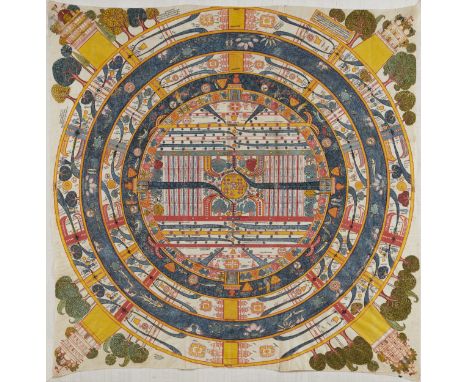
ADHAIDVIPA PATA DE MADYALOKAGUJARAT, XVIIIE SIÈCLEDistemper on cloth. 119 x 117 cm (46 7/8 x 46 in.), irregular Footnotes:AN ADHAIDVIPA PATA OF MADHYALOKA GUJARAT, 18TH CENTURY古吉拉特邦 十八世紀 耆那教宇宙學中觀世界圖 Published: Jan van Alphen, et al., Steps to Liberation: 2500 Years of Jain Art and Religion, Antwerp, 2000, p. 177, no. 42. Exhibited: Steps to Liberation: 2,500 Years of Jain Art and Religion, Etnografisch Museum Antwerpen, 26 May - 15 October 2000. Provenance: With Claude de Marteau, Brussels, by 1980s Discussing this Jain cosmological map, which Claude de Marteau displayed prominently in his dining room, van Alphen notes, 'This extremely detailed and richly coloured representation of Adhaidvipa - the 'two and a half' continents - is most probably based on an early seventeenth-century model. However, the clothes worn by the various figures, the architectural details of the palaces and also the aquatic figures point to the eighteenth century. The painting shows some unusual features, the extra ring between the central continent, Jambudvipa, and the surrounding salt ocean, Lavanoda, for instance. It is abundantly filled with flowers and trees in a purely decorative style. Great care has been taken in the painting of the figures in the oceans, one of the few areas in which the artist enjoyed a measure of freedom in the otherwise strictly defined representation of the madhyaloka, 'the middle world'. A great many inscriptions are included within the area of the 'two and a half' continents, which are more usually found around its circumference.'For further information on this lot please visit Bonhams.com


17x 18th, 19th and early 20th Century books. Including; The Modern Traveller; Russia (pub. Duncan 1825) with foldout map. Travels in Italy by M. Valery (pub. Baudry's European Library 1852). A Summary of Roman Law by Dr. Taylor (pub. T. Payne 1772). Mr. Midshipman Easy. Fairy Tales by Andersen (1908). Trafalgar (1905). Life of Samuel Johnson by Boswell - 3rd vol. (pub. 1799). The Biographic Treasury (in 5 vols - pub 1870). Plus a number of other odd volumes from various works. QGC-GC. £30-50


-
109182 item(s)/page