We found 109198 price guide item(s) matching your search

Refine your search

Year

Filter by Price Range
  • List
  • Grid
  • 109198 item(s)
    /page

Lot 2038

A small quantity of books to include three copies of Familiar Wild flowers by F.E. Hulme, Complete Works of William Shakespeare, The Britannia or an Illustration of The Kingdom of England, The Water-Babies, a Map of The Country of Devon 1765 by Benjamin Donn.

Lot 1083

A quantity of old sheet music including, International Song Book, Favourite Carols, Bach, etc, together with a framed old Monmouthshire map.

Lot 1122

A framed and glazed Map of Staffordshire by Rob(ert) Morden (a/f), 11 1/2" x 14".

Lot 184

' Wonderful Britain ' early-to-mid 20th century sectional road map, 32 cards, contained within a canvas folder, 28.5cm long together with The Motor Map of England, Wales & Southern Scotland, 6 sections

Lot 283

Antique Hand Coloured Map of Bremen and Hamburg, 35.5cm x 27cm together with Reproduction Saxton's Map of Dorsetshire, Reproduction Joannes Blaeu Map of Essex and Reproduction Antique Map of Monmouthshire

Lot 318

Large Collection of Unframed Oils, Watercolours, Pencil Drawings, Prints, Map, etc

Lot 353

Robert Morden (British c.1650-1703): 'The East Riding of Yorkshire', engraved map with hand colouring 36cm x 42cm, a Judges' tinted photo. of Robin Hoods Bay, and a monochrome photo. of Hutton-Le-Hole (3)

Lot 1431

The Cyclist Pocket Touring Maps of Britain, Philip's tape indicator map of London, stamps:- One Tray.

Lot 1534

A Pair of Embossed Pictures of Dead Game and Birds, on simulated wood grounds, circa 1900, in pweriod frames, 45.5 x 38cm overall; a map of Cumberland, hand coloured, circa XIX Century, Yorkshire East and West Riding, and Lancashire maps. (5)

Lot 632

Framed Bleu's Atlas of Scotland surveyed by Timothy Pont and Robert Gordon. This map is from 1663 with french text depicting Fife. [62x73cm]Along with a engraving of Dunbar Close [35x28cm]

Lot 703

A Lot of three Scottish Clan Stewart books: The Historical Geography of the Clans of Scotland by T.B. Johnstone, and Colonel James A. Robertson, Second edition. 1873- [fitted with map]. The Stewarts of Appin by John H. J. Stewart and Lieut,-Col. Duncan Stewart, Late 92d Highlanders, 1880- comes with various letters from the Stewarts society. The Story of the Stewarts- Printed for the Stewart Society 1901.

Lot 1051

British School (20th Century)''SS Nerehana, English Channel'' Indisticlty initialled, inscribed and dated 1915, watercolour and gouache, together with four landscape watercolours by P*Woolridge, Peter Shutt, two by W Miller Knight and an 18th century Yorkshire road map (6)

Lot 1066

A map of North Riding of York, C & J Greenwood, 1834, and another, both framed

Lot 1078

Robert Morden (c.1650-1703) "The County of Monmouth", together with a further map of Monmouth by Morden and a reproduction map of Monmouthshire by Richard Blome (3)

Lot 1199

A George II Walnut Fretwork Mirror, 61cm by 35cm, together with a 19th century picture clock depicting Elizabeth Tower, a framed fabric map of Europe and a wicker and bamboo cradle (4)

Lot 245

Assorted Mainly Early 20th Century Costume Accessories, comprising pair of cream silk sleeves, another pair in cotton with embroiderySavecotton collar and shoulder capesthree embroidered silk sashes woven with floral designs in purple, red and pale blueWWII items including a pair of gents cream evening gloves, Towles Ltd single stocking dated 1952, silk map of North Africa, Souvenir of France silk handkerchiefmodesty panels, mittens, stockings etc(one box)

Lot 393

Three framed maps, hand-coloured map - 'Britannia Romana', 36cm x 42.5cm, Somersetshire and Cornwall, all framed and glazed

Lot 81

An Architect's cased street plan model, with streets, houses, office buildings, ecclesiastical buildings, etc, 76 x 75 x 15cm and a map of Toxteth and Blundellsands (2).Qty: 2Please note that this lot is not suitable for our in-house postage service.We would recommend booking a collection slot for this lot or contacting Mailboxes Etc for postage of this lot, their details can be found on www.adampartridge.co.uk/services/postage-shipping/

Lot 319

A silk-style military WWII escape and evasion map of North Africa containing Morocco, Algeria, Tunisia, Italian Libya and Spanish Rio De Oro and a WWII commemorative velvet embroidery with images of pharaoh, Pyramids and palm trees in the desert, embroidered 'Egypt 1943' (2).Qty: 2

Lot 324

A quantity of interwar maps, diaries and other ephemera relating to military issue, to include a Flight Diary for Singapore K383 dated October 1936, also a War Office map, newspaper cuttings, photocopies, miscellaneous press-style photographs including military related examples, to include 'The RAF Mountaineering Association Himalayan Expedition to Climb Masherbrum (K1)', depicting the team and their incredible paper tent, dated 1981, together with a folder containing the Royal Air Force Museum Hendon Visual Tour Transcript and a quantity of coloured photographs of exhibits, etc.

Lot 1539

An antique map of Cheltenham & Cirencester by Walker after Creighton, 25 x 19cm

Lot 1651

A 17th Century colour map of Hampshire by Thomas Bassett

Lot 1065

DOUGLAS, R. China 1st.ed. 1882, London, 8vo orig. gt. dec. cl. fldng. map plus 5 other travel books (6)

Lot 134

A collection of framed prints, photographs, needlework picture, map and similar, varying image sizes.

Lot 347

Mixed pictures to include five engravings by E. Sharland, 19th century map of England and othersLocation:

Lot 105

A metal tube containing various late 18th/19th century legal documents relating to property in the and around the town of Setterington in the county of York, along with an 18th century map of the township of Setterington by S Dickinson and R Stickney Surveyors, circa 1797

Lot 161

Saxton - Kipp, hand coloured engraved map - Dunelmensis, map of Durham, glazed frame

Lot 196

Robert Morden - 18th century map of Essex in glazed frame, together with a Morden map of Suffolk and two facsimile maps. (4)Essex map in good condition, in a later frame. The Suffolk map is unframed and is creased with a small tear. The other maps are later copies.

Lot 429

Pencil study of a court room at the Old Bailey, 19th century engraving of a cartoon, map and other pictures and engravings.

Lot 290

West German M62 Steel Helmet complete with liner size 53-55 and webbing chinstrap: small map case maker marked "Edward Standford Ltd, London: WW2 British Booklet "Ranks and Badges" published 1940: Booklet "Ships in Bottles". (4)

Lot 457

Cartography - Richard Palmer, Relievo Map of Palestine or the Holy Land, Illustrating the Sacred Scriptures and the Researches of Modern Travelers, published by Dobbs, Baily & Co., London, [1845], 55.5cm x 45cm, maple frame

Lot 484

Cartography - a 19th century lacquered brass tripod map reading lens, 4.5cm diam

Lot 710

Robert Morden (c. 1650 - 1703), by, two-page map, Darbyshire (sic, Derbyshire), [Published and] Sold by Abel Swale, Awnfham (sic) and John Churchill, London, [n.d., early-mid 18th century], hand-coloured copperplate engraving, 34cm x 40cm

Lot 2434

A MODERN COFFEE TABLE, 30X23" WITH BRASS FRAME ENCLOSING 1961 SAXTON'S MAP OF LANCASHIRE

Lot 203

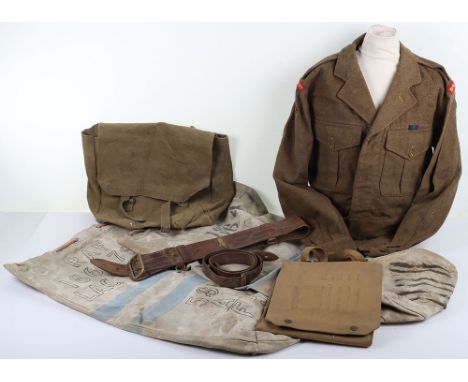
A SELECTION OF BOOKS AND MANUALS RELATING TO THE ROLL OF THE HOME GUARD DURING WW2, the books include the story of A Sector home guard on Warwickshire, a war time map showing the positions of the Home Guard Headquarters, pill boxes, road blocks etc in Stafford, Rugeley and Cannock,2 home guard shoulder titles, leaflets relating to 39th Cheshire home guard plus other manuals relating to the RAMC, home guard rules and regulations etc.

Lot 224

A GROUP OF WORLD WAR ONE MEDALS TOGETHER WITH POSTCARDS & MAP, together with a Boer War Medal, as follows, British War & Victory Medal, named to 58377 Pte F.B. Cumberlidge, Royal Warwick Regiment, together with a Queens South Africa Medal bars, Cape Colony, Orange Free State, Transvaal named to Gunner J Victor O Battery RHA & a number of postcard photos of WW1 sites etc collected by Cumberlidge, a Northern France War office map dated 1914, South Staffs Regiment Cap badge, & a 1939 dated Gas mask. plus a Bronze Royal lifesaving award medallion dated 1944 B Cumberlidge

Lot 200

AN ALBUM OF WWII COMMEMORATIVE COIN AND STAMP COVERS, to include a limited £2 D-Day Anniversary coin cover in its folder, liberation of Jersey £2, Dunkirk evacuation £5, a collection of Battle of Britain first day covers and £5, 50p, one crown coins, return of the Vulcan coin cover, a limited RAF centenery limited to 1000 coin cover, a loose £5 80th annaiversy in plastic casing and royal airforce 50p, etc, all look to be in great condition, together with a souvenir paper copy of Berghofbunker map and other military related ephemera

Lot 165

John Blaeu original sparsely coloured map of Pembrokeshire and Carmarthenshire. 44x53cm approx. Framed and glazed. (B.P. 21% + VAT)Border and some margin with plate mark visible but not removed from frame.  Later coloured.  Appears good overall condition.  Modern, unsuitable frame. 

Lot 163

Reproduction John Speede map of Pembrokeshire. Unframed. (B.P. 21% + VAT)

Lot 161

John Blaeu original sparsely coloured map of Pembrokeshire and Carmarthenshire. 41x53cm approx. Framed and glazed.(B.P. 21% + VAT)Some margin shows outside mount but plate mark not visible all the way round.  Some discolouring, later coloured.  Back enclosed. Modern, unsuitable frame.

Lot 162

Joan Jansson, original sparsely coloured map of South Wales. 41x53cm approx. Framed and glazed. (B.P. 21% + VAT)

Lot 217

A MARK 13 TYPE G MAP READING LAMP, and an American air horn, the lamp looks to be in good condition , but the air horn is in poor shape, neither have been tested

Lot 839S

Prints, a map, a pastel and a gilt framed mirror.

Lot 1202

A LARGE VINTAGE GERMAN WALL MAP OF AUSTRALIEN UND POLYNESIEN

Lot 1312

Framed map of The Salmon Rivers of Scotland by Nigel Holdsworth, 44 x 57 cm. Not available for in-house P&P

Lot 24

After Geoff Bell. Aries Railway Map of Manchester and District, presented to the Manchester Mess by George Bell, October 1981, 38cm x 53cm, framed and glazed, with booklet.

Lot 852

Norden's Map of Windsor Forest 55cm x 41cm

Lot 70

Tithe Map of Adswood 1844 land owners plots

Lot 107

A framed John Speed map of Flintshire, Wales dated 1610, 22.5in x 18in including frame

Lot 849

An early framed and glazed map - Gloucester to Coventry by Thomas Gardner.

Lot 1559

A f/g map of the Dordogne dept de la Dordoyne from engraving by FF George and CH Smith

Lot 1120

A framed map of part of warwickshire tittled John Speed 1676 69cm x 57cm.

Lot 40

Asian Art Collection. Unusual Drawing of a Character with Dragon Shield and Bonsai Tree Head Wear(with unknown Pencil Signature), A Japanese Lakeside Picture with Gilt Highlights, Thailand Tissue Paper Tracing of a Buddha and Masked Attendant, Another Thailand Framed Print and a Tokyo Bape Map. Tracing is measuring 50cm x 46cm. 亚洲艺术收藏。带有龙盾和盆景树头饰的不寻常人物素描(铅笔签名不详),带有金边亮点的日本湖边图片,泰国薄纸描绘的佛像和蒙面侍者,另一幅泰国裱框印刷品和一张东京 Bape 地图。 Tracing 尺寸为 50cm x 46cm。

Lot 62

London Maps and Transport Timetables 1930's - 1951. Alexander Gross / Geographers' Map Co. - The Authentic Map of London, Olympic Games 1948 Visitors Guide, 1947 Bus Map Central area issue No. 1, 1936-7(Winter) Trolleybus & Tram Map and 1951 Railways Diagram of Lines. Generally good condition with some foxing and stains

Lot 324

Royal West Kent Battledress Blouse and Equipment: Blouse has titles and Home Counties Training Brigade formation badges to arms , label inside dated 1952, with Sam Brown belt, war time dated map case and kit bags. 6 items

Lot 10

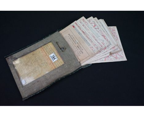
Identity Documents in Holland Belgium and Luxembourg (Supreme Headquarters Allied Expeditionary Force Evaluation and Dissemination Section, July 1944. British & US Confidential. Considerable detail and with most documents clearly illustrated in colour ie Buckkehrschein (Return Pass for Workers in Germany). Covers Holland, Belgium and Luxenbourg under German occupation. c. 250pp., loose Restricted areas map for Holland and Belgium tipped-in. Very nice condition.

Lot 130

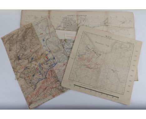
Trench Maps World War One. Unusual original Trench map of Saint Quentin and area around Neuville St Amand, Itancourt and Mezieres covering the area South to below Vendeuil, 1:20,000 with a number of trenches shown, Mars 1917, Published by the French Army, large thick paper map. Together with German Trench map centered on Regnieville, Fey etc with German units added by hand and French gun positions shown, together with dense trench systems, dated 1918 in pencil and Feldart Regt no 95. Note is two spliced together and may have been cut down. Two further Trench maps of the Russian Front produced by the German Army c.1916 with trenches shown, 4 in all.

Lot 369

WWII (1945) 25 Ind Div order sheet : secret order No. 10 (copy no 25) t/w double sided silk map of Siam (Thailand) / Malaya / Sumatra (central) - 95cm x 63cm & a 2 part Military and Police map of Great Britain and Ireland compiled by MI5 War office (1918) - a/f

Lot 631

Framed 1676 map of 'The North and East Riding of Yorkshire' by John Speed (1552-1629) and sold by Thomas Bassett and Richard Chiswell - 41.5cm x 54cm~ the map is in a double sided glass frame & the map itself does have some losses down the original 'fold'

Loading...Loading...
  • 109198 item(s)
    /page

Recently Viewed Lots