![[Lot of 2] A New Map of New York with Its Canals, Roads & Distances [and] City of New-York A. A New Map of New York with](http://lot-images.atgmedia.com/SR/36385/2906594/264-2014581323_468x382.jpg)

[Lot of 2] A New Map of New York with Its Canals, Roads & Distances [and] City of New-York A. A New Map of New York with Its Canals, Roads & Distances, (13.9 x 11.5""). Handsome map of the state showing counties, roads, railways, canals and towns. A Profile of the Erie Canal appears below the title. At right are 3 tables detailing the steamboat routes from New York to Albany, New York to Niagara Falls, and New York to Philadelphia.B. City of New-York, (12.4 x 15.5""). This plan covers Manhattan as well as parts of Williamsburg and Brooklyn. Manhattan is shown in great detail as far north as 37th Street. Locates ferry routes, docks, and names all streets. Tables at sides index more than 200 important public buildings, hotels, and churches. Original color with a few faint spots and marginal toning. The New York state map has a damp stain at left, a chip at bottom right, and a few short edge tears, all outside the map image. Thomas, Cowperthwait & Co., 1850
We found 109182 price guide item(s) matching your search
There are 109182 lots that match your search criteria. Subscribe now to get instant access to the full price guide service.
Click here to subscribe- List
- Grid
-
109182 item(s)/page

Map of the State of New York This scarce piece is a decorative map of the state that includes a dramatic and beautiful bird`s-eye view of Niagara Falls at upper left. The map is colored by county with much detail of towns and villages, canals, railroads, wagon roads and watershed. A second inset shows all of Long Island on the same scale as the main map. The titling is in fancy text with flourishes and banknote-style pattern behind. A wide, handsome border surrounds. Blank verso. An uncommon map by Charles Magnus, 12 Frankfort St. New York with his own embossed stamp imprinted directly below the title cartouche. Backed with tissue to reinforce and repair several short tears and two small areas of loss near the center of the map in Seneca and Tomkins county. There is light toning near the middle of the map with a few small edge chips at top confined to the blank margin. 19.5 W x 24 H Magnus, Charles 1860

A Map of the History of New York State This unusual map is chock-full of details illustrating the history of the state. It covers a period of 400 years from Giovanni da Verrazzano`s discovery of New York Bay in 1524, to the Dutch settlements of the early 17th century where Peter Minuit bought the island of Manhattan for 60 guilders, and to the completion of the Erie Canal in 1825. Various places and events are described, located and dated throughout the map, and several cities have a detailed chronology. Includes insets of ""Old New York"", ""Niagara"" and ""Two Great Rivers."" Decorated by five coats of arms and an attractive compass rose. Created by Alexander Flick and Paul Paine. A very bright, colorful example with just a few edge tears confined to the bottom blank margin that have been closed on verso with archival tape. 20.8 W x 28.2 H 1928

Sketch of General Grants Position on Long Island Charles Stedman was an American-born officer who served in the British Army during the American Revolution. Stedman served under Howe, Clinton and Cornwallis, and wrote a history on the war with explanations of the military campaigns and depictions of battle plans. This plan depicts the movements of Admiral Howe, General Grant, and General von Heister during the Battle of Long Island on Aug. 27, 1776. The British camps and the American camps, under the command of General Sullivan and Major General Stirling, are also shown. Geographical and topographical features are illustrated in detail. Issued folding, now pressed, with light offsetting. A binding trim at bottom right has been replaced with old paper, and an associated binding tear that enters 2"" into map has been archivally repaired. 13.9 W x 10.6 H Stedman, Charles 1794
![[Lot of 3] Map of the Deep River District North Carolina [and] Map of a Part of North Carolina Showing the Routes Connecting](http://lot-images.atgmedia.com/SR/36385/2906594/272-20145813217_468x382.jpg)
[Lot of 3] Map of the Deep River District North Carolina [and] Map of a Part of North Carolina Showing the Routes Connecting with Deep River District Constructing & Proposed [and] Report of the Secretary of the Navy This report was a result of a Senate resolution intended for ""expediency of establishing, at some point in the State, machine and workshops for the construction of engines, boilers, &c., &c., for naval vessels."" Captain Wilkes led this effort and determined that the Deep River District would be a favorable area for such operations. Included with the 29-page disbound report is one plate and the following two maps: A. Map of the Deep River District North Carolina (19.2 x 13.1""). Focused on the Deep River dividing the counties of Chatham and Moore, the map identifies the coal field and slate deposits following the river. Seven different geologic types are represented. On a detailed scale of 0.75"" per mile. Condition: Issued folding with moderate color offsetting and several fold separations that have been partially closed on verso with archival tape. B. Map of a Part of North Carolina Showing the Routes Connecting with Deep River District Constructing & Proposed (7.8 x 9.1""). This is a wider view of the area showing how the transportation network was connected to the Deep River District. Locates the Charlotte and Wilmington R.R., Wilmington and Raleigh R.R., as well as several proposed roads. Condition: Issued folding with light toning primarily along the folds and one fold separation. Report and plate are good with faint toning and a few minor edge tears. See description above for condition of maps. U.S. Navy Dept., 1858

Plan of the Remains of Some Ancient Works on the Muskingum This rare map represents the birth of American Anthropology as it is ""thought to have been the first description and plan of an American earthwork ever published"" (American Anthropologist, Vol 10, p. 343.). The map was likely sketched by Captain Jonathan Heart of the First American Regiment. Heart was commissioned a Captain by Congress and was ordered to the Muskingum Valley to protect the surveying parties there. It was during his service there that he produced the plan of the ancient Indian works located near present-day Marietta, Ohio. The plan with a key for circular mounds, walls, caves and graves details an area of about one square mile on the east bank of the Muskingum River. The plan is on a scale of 10 chains to an inch (666 feet). Issued folding with several extraneous vertical creases, minor soiling, and a small binding trim at lower right that has been replaced with old paper. 7.1 W x 8.6 H Columbian Magazine, 1787
![Indian Territory [with] Indian Civilization: A Lecture by Stanley Pumphrey This map is based upon the uncommon first edition](http://lot-images.atgmedia.com/SR/36385/2906594/274-20145813220_468x382.jpg)
Indian Territory [with] Indian Civilization: A Lecture by Stanley Pumphrey This map is based upon the uncommon first edition of the series of General Land Office maps delineating the status of lands allocated to various tribes, but with slightly fewer details. Indian removals from `home lands` began as early as 1817 and in the years following many of the principal eastern Indian tribes were relocated. By 1879, the region was divided into a myriad of Indian nations and reservations, all but the smallest of which are annotated here with references to one or more treaties relating to their formation. In addition to the tribal boundaries, the map includes fascinating detail of early forts, settlements, roads and trails. The territorial capital is at Ockmulgee. The map is still bound into the 52 pp. report of ""The Bible and Tract Distributing Society"", which discusses the mistreatment of the Indian population. The society`s main purpose was to publish and disseminate Christian literature. Octavo, hardbound in red cloth covered boards with gilt title on front cover. Condition code is for the map which is near fine with just a little faint toning along one fold. Text is mostly clean and tight with a faint damp stain confined to the bottom edge of the first few sheets. Covers are lightly worn and well faded with a small chip at the bottom of the spine. 21.9 W x 27.8 H 1876

Indian Territory This is a reduced-size version of the large map published in the G.L.O Annual Report for 1883. The maps are virtually identical except this smaller edition neither has the surrounding notations nor a legend to explain the coloring. It is a detailed and informative map that shows the locations of tribal Indian lands and provides some data on the pertinent treaties involved. The map does not include the panhandle, which by this time is Public Lands. Blank verso. Drawn by G. P. Strum, principle draughtsman for the G.L.O. while N.C. McFarland was its commissioner. A most uncommon edition that was published to accompany ""Public Domain"" by Thomas Donaldson. A clean example with a nearly invisible 2"" binding tear that has been closed on verso with archival tape. 12 W x 16 H General Land Office, 1883
![[Map and Report] Map of Oklahoma Territory [with] Report of the Governor of Oklahoma This map was compiled from the correcte](http://lot-images.atgmedia.com/SR/36385/2906594/276-20145813224_468x382.jpg)
[Map and Report] Map of Oklahoma Territory [with] Report of the Governor of Oklahoma This map was compiled from the corrected map of the General Land Office 1898 and from data on file in the territorial office under the direction of Harry King, Chief of Drafting. It is an attractive map with great attention paid to detail, including railroads constructed and proposed, as well as roads and trails. The map covers present-day western Oklahoma with the panhandle, but only the western portion of what was then Indian Territory is shown. Indian reservations within the territory are shown, including the Wichitas, Kiowas, Comanches and Apaches. Land Offices are located at Woodward, Alva, Enid, Perry, Guthrie, Kingfisher, Ft. Reno, Oklahoma City, Mangum and Lawton. The map is still bound into the original report which includes 26 plates related to the development of the territory (key buildings, agriculture, forest reserves) and 2 smaller folding maps showing average precipitation and temperature. 8vo, 133 pp. in original clay colored wrappers. Condition code is for the maps, plates and text which are all clean, bright and nearly flawless. Wrappers show only very light wear with a few cracks along the spine and a couple of small chips. 14.4 W x 21.9 H General Land Office, 1901

Oregon`s Historic Trails and ""Story Spots"" This colorful map is flanked by 83 ""story spots"" of early Oregon history, as well as a few points in neighboring Washington and Idaho. The map identifies the Old Oregon, Lewis and Clark, Barlow, Applegate and Fremont trails. Illustrated with numerous small vignettes of wildlife, stage coaches and native scenes. Created by Colista Dowling and produced for the Oregon Council of the American Pioneer Trails Association. A clean, bright example. 16.9 W x 21.9 H 1945

Carte Geographique, Statistique et Historique de la Pensylvanie This attractive copper engraved map is surrounded on three sides with French text describing Pennsylvania, its history, products, climates, and other information. McKean, Jefferson, and Potter are depicted although they were not officially counties until 1826, 1830, and 1835, respectively, while the eastern border of Clearfield appears in its 1822 configuration. Buchon produced the French edition of Carey & Lea`s American Atlas. He used a better quality paper and today his maps are generally found in better condition than their American counterparts. The dimensions given are for the map only; overall, the large folio sheet measures 26.4 x 21.0"". Original color on a clean, bright sheet of sturdy paper with a small abrasion in the text column to the right. 11.4 W x 17.3 H Buchon, Jean Alexandre 1825
![[Lot of 2] A New Map of Pennsylvania with Its Canals, Rail-Roads &c. [and] Philadelphia A. A New Map of Pennsylvania wit](http://lot-images.atgmedia.com/SR/36385/2906594/279-20145813228_468x382.jpg)
[Lot of 2] A New Map of Pennsylvania with Its Canals, Rail-Roads &c. [and] Philadelphia A. A New Map of Pennsylvania with Its Canals, Rail-Roads &c., dated 1850 (14.3 x 11.6""). A very handsome map with good detail throughout locating numerous towns and villages, rivers, canals, and railroads. Tables give the steamboat routes between Philadelphia to New York via Trenton, New York via Bordertown, and Baltimore via New Castle, and the route between Pittsburgh and Louisville. Also included are profile views along the Pennsylvania Canal and another along the Columbia Railroad. Decorative borders.B. Philadelphia, circa 1850 (12.8 x 15.8""). This nice mid-19th century plan of the City of Brotherly Love is divided into wards as indicated in a key at bottom. An extensive index table at right lists banks, churches, hotels, and public buildings. Original color with a few faint spots within the image and toning in the blank margins. The Philadelphia map has a couple minute worm holes that are only visible when held up to light. Thomas, Cowperthwait & Co., 1850

Carte Geographique, Statistique et Historique du Rhode-Island This attractive copper engraved map details counties, roads, and towns. The map extends to include Block Island. It is surrounded on three sides with French text describing the state, its history, commerce, manufacturing, education, religions, etc. A table lists all governors beginning with Benedict Arnold in 1663 to William C. Gibbs who began serving in 1821. The map was originally engraved by Young & Delleker in 1822. The size given is for the map only; including the surrounding text, it measures 23.8 x 18.3"". Buchon produced the French edition of Carey & Lea`s American Atlas. He used a better quality paper and today his maps are generally found in better condition than their American counterparts. On sturdy paper with just a few faint spots. 11.3 W x 8.3 H Buchon, Jean Alexandre 1825

The State of South Carolina: from the Best Authorities This is the first state of this fascinating map of South Carolina that came from the first atlas of America published in America. The topography of the state is shown in fine detail, as are precincts, towns, waterways, and roads. As a result of the distorted scale of the latitude measurements, the state appears stretched from north to south. In addition, the northwest border with Georgia extends Carolina farther west than is accurate. Two of the most influential names in American cartography were Samuel Lewis and Mathew Carey. Samuel Lewis was a celebrated draftsman and cartographer who learned his trade from the prominent English cartographer Aaron Arrowsmith. Engraved by William Barker. There are centerfold separations at top and bottom, as well as a slight tear just entering the neatline, all of which have been professionally repaired. There are also two tiny pinholes, an extraneous crease, and a small stain at left. 15.4 W x 17.4 H Lewis/Carey, 1795
![[Lot of 2] Charles Town, South Carolina, with a Chart of the Bars & Harbour [and] Charleston A. Charles Town, South Caro](http://lot-images.atgmedia.com/SR/36385/2906594/285-20145813239_468x382.jpg)
[Lot of 2] Charles Town, South Carolina, with a Chart of the Bars & Harbour [and] Charleston A. Charles Town, South Carolina, with a Chart of the Bars & Harbour, by J. Lodge, from Westminster Magazine, dated 1780, hand color (7.7 x 7.4""). This Revolutionary War period chart of Charleston was published just one month after British General Sir Henry Clinton`s successful siege on Charleston. The chart gave the British readership of Westminster Magazine a glimpse of the war. In addition to a note identifying Clintons advanc`d Post, the map includes two British warships, the Acteon and the Sphinx, marking the Battle of Sullivan`s Island. It also features military forts and installations, a lighthouse, depth soundings, and details about bridges and channels. The map is oriented with north to the right. Condition: Issued folding with minor soiling, a few extraneous creases, and a few short fold separations outside the map image. Ref: Jolly #WEST-8.B. Charleston, from Fanning`s Illustrated Gazetteer of the United States, circa 1853, black and white (4.8 x 7.9""). An informative Antebellum city plan of Charleston that features streets, a railroad track leading into the city, rivers, and many sites in the town. A key at the top locates 26 places of interest, including the College of Charleston, the Fireproof Building (which now houses the Charleston Historical Society and is thought to be the oldest fireproof building standing in America), the medical college, and a Masonic hall. Condition: There are a few short tears and small chips along the left edge, most of which have been closed on verso with archival tape and only two that enter the neatline. See description above. 1780-1853

Siege de Charlestown This fascinating Revolutionary War map depicts Charleston under British control after the siege of 1780. British ships fill the waterways and the location of their camp is indicated. The Siege of Charleston was a major victory for the British, who had shifted their attention to the southern colonies in the final stretch of the war. Major General Benjamin Lincoln surrendered approximately 5,000 American troops after six weeks of battle-- the largest number of American forces to surrender throughout the entire war. A nice impression with faint offsetting and some printer`s ink residue along the plate mark. 8.1 W x 12.4 H Marshall, John 1807

S.W. Territory This is the first state of this early American produced map. While simply drawn the map includes interesting information including the locations of early settlements, military reservations, and Indian villages. The Mero district is located and divided into three counties: Sumner, Davidson, and Tennassee. Nashville is here called Naskville. Fort Massac is shown on the Ohio River, and there is a note near Knoxville describing the way to Pensacola as being nearly level. The map includes a portion of the adjoining states of Kentucky and Georgia. This is the first state; later states of this map change the title to ""Tennassee."" In 1788 North Carolina established a Superior Court district to serve the Cumberland frontier. The district was named in honor of the Spanish governor of Louisiana, Esteban Rodrigues Miro, who had assisted the Americans during the Revolutionary War. The naming of the new district is credited to James Robertson, who was attempting to soothe tensions between the U.S. and the Spanish colonial government and gain Miro`s assistance in controlling the Creeks and Chickamaugas, and to open the Mississippi River to Cumberland travelers. Robertson and his allies persuaded the North Carolina legislature to name the new district Mero, inadvertently misspelling the name. The first judge of the Mero District Superior Court was John McNairy, and one of his first actions was the appointment of Andrew Jackson as district attorney. The court served Davidson and Sumner Counties, as well as the counties created out of them, until 1809, when the superior courts were abolished. A nice impression issued folding, now flat, with faint offsetting, some of it from an opposing page of text. There are remnants of hinge tape and an ex-library stamp on the verso. 6.1 W x 7.4 H Scott, Joseph 1795

Geological Map of the Route Explored by Capt Jno. Pope ... from the Red River to the Rio Grande... This colorful map details the countryside in a band along Capt. Pope`s route from Fort Towson, Oklahoma, to El Paso and Dona Anna on the Rio Grande. Five geological types are delineated through hand coloring and indicated in a legend. Good detail of the region`s watershed, naming the Rio Grande, Concho, Brazos, Trinity, and Red rivers. The location of forts, several towns, and the emigrant crossing on the Pecos River are shown. Issued folding with some minor toning. 9.9 W x 22.9 H Pope, John 1854

Texas A historically interesting county map of Texas showing good detail. A table provides a key to the symbols used to indicate towns, post offices, stage roads and list names of 65 counties. Of particular note is the identification in outline color of the Gebiet des Texas Verins with the route from the port of Indianola to the German settlements. Over half of the state is unorganized and mostly blank but it does list Indian tribes and other place names, e.g. White Sand Hills, Flatrock Ponds, Castle Mountains, Horsehead Crossing, etc. Finely engraved with delicate outline coloring, minor offsetting, just a few edge tears confined to the blank margins, and light toning along sheet edges. 8.3 W x 10.5 H Lange, Henry 1854

Carte du Texas pour les Missions et Voyages Scarce map of Texas based on Jacob de Cordova`s 1849 depiction showing the state west to the Pecos, here labeled R. Puerco, just north of the Rio Grande. Even though published in 1857, this French map illustrates Texas after it became the 28th state in 1845, but before the Compromise of 1850, when the present boundaries were established. There were four empresario grant type colonies established during the Republic of Texas period, one being the Fisher and Miller Colony, shown here north of Fredricksburg. The other three that are no longer noted on this map were Peters` Colony, Castro`s Colony and Mercer`s Colony. These types of colonies were changed to be more in order with regular US land grants. West Texas is noted as being the Solitudes habitees par les Comanches. This map illustrates the travels of Abbe Emmanuel Domenech in Texas; first in 1846-50, and then again in 1851-2. Domenech was the first Catholic priest to be ordained in Texas and was charged with the establishment of the Catholic hierarchy in Texas, amid the tensions of the boundary disputes with Mexico. On his second journey he based himself in Brownsville and visited neighboring places in Texas and Mexico. The tracks of his missionary activities are shown in orange on the map. This map was engraved by Erhard and published by Fevrier. It is an unusual and important map in the history of the state of Texas from the first edition of Domenech`s Journal. Issued folding with a 1.5"" binding tear at right that has been closed on verso with archival tape and mat burn confined to the blank margins and on verso. There are some light pen marks in the image. 17.8 W x 13.8 H Domenech, Emmanuel 1857

County Map of Texas One of the most attractive maps of the state of Texas, inset with a map of Galveston Bay, and Vicinity. West Texas is made up of Young Territory, Bexar Territory, El Paso and Presidio counties, and clearly shows the Llano Estacado or Staked Plain with a notation about the region being ""destitu[t]e of both wood and water."" Erath County is mistakenly identified as ""Earth"" County. The map shows trails, roads, a limited railroad system that extends only into Austin, and proposed railroads indicated by dashed lines. The map is surrounded by a fine floral border. Copyright date 1860, published circa 1864. The county development is up-to-date for 1864 as Dawson County, abolished in 1866, is included. There are a few errant spots of colorist`s ink and marginal toning, else fine. 10.7 W x 13.3 H Mitchell, Samuel Augustus 1860

Johnson`s New Map of the State of Texas Large, handsome map with county development mostly in eastern Texas and only the three large western counties of El Paso, Presidio, and Bexar in the west. The panhandle, noted as the El Llano Estacado or The Staked Plain (Elevated Table Land, without Wood or Water), includes a large section that is unorganized. Nice depiction of the wagon roads, many named, with several completed railroads including the Houston & Guaymas R.R. Insets include Plan of Sabine Lake, Plan of the Northern part of Texas, and Plan of Galveston Bay. Decorative scrollwork border. Original color with minor offsetting and light toning primarily along the sheet`s edges. 16.7 W x 24.5 H Johnson & Ward, 1864
![[Lot of 2 with Same Title] County Map of the State of Texas Showing Also Portions of the Adjoining States and Territories Th](http://lot-images.atgmedia.com/SR/36385/2906594/294-20145813255_468x382.jpg)
[Lot of 2 with Same Title] County Map of the State of Texas Showing Also Portions of the Adjoining States and Territories This lot includes two double-page maps of Texas showing the growth of the state over a nine-year period. The maps present an excellent view of the county development with only the large regions of West Texas yet to be organized. Galvestons role as a main port of entry is obvious as it is depicted in a large inset. The Llano Estacado, or Staked Plain, is shown extending from the New Mexico Territory through the Texas panhandle. In the later map, the railroad network has extended its reach to El Paso and Laredo. A. County Map of the State of Texas Showing Also Portions of the Adjoining States and Territories, by Samuel Augustus Mitchell, dated 1879. Condition: Original color with a 2"" wide faint damp stain along the centerfold with light toning along the sheet edges. (B) B. County Map of the State of Texas Showing Also Portions of the Adjoining States and Territories, by William M. Bradley & Bros., dated 1887. Condition: Attractive original color with just a few tiny edge tears confined to the blank margins. (A) See description above. 14.4 W x 21.3 H 1879-87

Map Showing the Route of the Arkansas Regiment from Shreveport La. to San Antonio de Bexar Texas Uncommon map covering east-central Texas from Shreveport on the Red River to San Antonio. The Old San Antonio and Nacogdoches Road is prominently shown. This fascinating map locates several very early settlements including Douglas, Nacogdoches, Crockett, Robbins` Ferry, Washington, Independence, Bastrop, Houston, Liberty, Austin, Saguin, and, of course San Antonio de Bexar. Good detail of the watershed delineates the flow of the Guadalupe, San Marcos, Colorado, Brazos and Sabine Rivers. Also locates several tributaries including the San Saba, Pecan, San Andres, Bosque, and Argentina Rivers, and the creeks of Brushy, Palo Pinto, Peach, Cibolo, Saloda, Lavaca, Village, Alabama, and Bidais. This map was among the maps submitted to Congress to illuminate the U.S. Army`s first explorations in Texas, and accompanied Capt. G.W. Hughes ""Memoir descriptive of the March of a Division of the US Army under the command of BGen. J.E. Wool from San Antonio in Texas to Saltillo in Mexico."" Issued folding with a narrow bottom margin and some light, extraneous creasing at left. 11.6 W x 17.2 H U.S. Government, 1846-50

A Draught of Virginia from the Capes to York in York River and to Kuiquotan or Hamton in James River This plan covers the southern Chesapeake Bay, James River, and York River, and is regarded as the first published regional map of Virginia. As Virginia`s population expanded dramatically during the early 18th century, settlers began moving further up the rivers in the Tidewater region in order to find good land. This growth created a need for more detailed and larger-scale maps of the region. This map was created by Mark Tiddeman, who conducted hydrographic surveys of the area as master of the Royal Navy ship Tartar from 1725-28. Tiddeman`s logbook survives in the British National Archives and includes notes about the Tartar stopping and inspecting ships encountered along the coast, suggesting that his mission in the area may also have included compliance checks to enforce British customs laws. Tiddeman`s chart is filled with extensive detail of soundings, creeks, inlets, and shoals, including Middle Ground shoal, which is noted as ""Almost Dry."" The cities of Williamsburg, Gloucester, York, and Norfolk are pictorially depicted. Just below the eastern panhandle is the notation ""Here the Tartar lost her Anchor Octobr. 17th 1726,"" referring to Tiddeman`s vessel. Trimmed to the neatline at top left with the neatline missing at top right and some soiling in the image. There are short centerfold separations at top and bottom as well as a number of edge tears and chips, most of them tiny with the exception of a 5"" tear into the image at top that has been closed with archival materials. 18.1 W x 23 H Mount & Page, 1751

Wisconsin A fine example of this early Mitchell atlas map featuring the distinctive green and pink hand-colored border and beautiful engraving. It shows county development as it stood in 1844 with the recent formation of Dodge, Sauk, Fond du Lac, and Portage counties. The huge Crawford County was organized in 1818. Here St. Croix County is named but has actually been disorganized and was legally considered as ""attached to Crawford."" Craver`s Claim, numerous Indian lands, and more are located. The Michigan border is here shown along the Montreal River to Lake Superior. An early and desirable edition of this map that appears unchanged from Tanner`s 1844 edition of the Universal Atlas. Mitchell took over publication of the atlas in 1846 with two editions published that year. Many of the maps of the first 1846 edition still carried Tanner`s copyright notice, but Mitchell removed all references to Tanner in the second issue of 1846. Original color with faint soiling. 16 W x 13.4 H Mitchell, Samuel Augustus 1847

Map of the Yellowstone National Park Compiled from the Official Explorations & Surveys of the Superintendent of the Park... This map is from the 5th Annual Report of P.W. Norris, Superintendent of Yellowstone National Park, and reissued in Donaldson`s Public Domain. The map itself is very detailed and locates the Upper, Shoshone, Gibbon, and Heart Lake Geyser Basins, Mud Geysers, and Mammoth Hot Springs to name a few. It shows geysers and hot springs in pink and planned hotel sites (12 in all) marked with large green stars. Topography is indicated through hachure. This map provides an early look at Yellowstone and the government plans for its development. Issued folding with a 6"" separation along one fold that has been closed on verso with archival tape. There is a binding trim at left and an associated binding tear that just enters the neatline and has also been closed on verso with archival tape. 15.3 W x 17.2 H Donaldson, Thomas 1881

The Famous Hysterical Map of the Yellowstone Park Including a Few Minor? Changes This graphic map of Yellowstone National Park was ""hatched & scratched"" by Jolly Lindgren. It depicts the park in a light-hearted manner, with a number of silly visual puns, including hot springs drawn as coils radiating sizzle lines, a belching cabin to mark Soda Butte, a pool table standing in for Congress Pool, and a holdup bear appearing as a bear with a pistol. Old Faithful sings, ""I`m Forever Blowing Bubbles,"" while Folsom Peak has a jail cell on top. Lindgren also inserts jokey asides, such as a parenthetical ""Are Ya Hurt?"" beneath Gibbon Falls and ""Hell for Certain"" under Brimstone Basin. The Lindgren brothers of Spokane, Washington, specialized in humorous maps of state parks. An alternate title surrounds the map: A Hysterical Map of the Yellowstone Park with Apologies to the Park Smileage Guaranteed. There is some toning evident around the sheet`s edges and one short edge tear at right that does not enter into the neatline. 16.6 W x 16.5 H 1936

Map of the United States and Texas, Designed to Accompany Smith`s Geography for Schools This great school atlas map with early territorial borders in the West features the Independent Republic of Texas with Austin shown as the capital by a large star. The Oregon Territory covers the northwest and extends well into Canada. The huge Indian Territory lies north of Texas and extends to the Mandan Territory, which in turn goes to the border with Canada. Iowa Territory is in a rare configuration, stretching from Missouri to the Canadian border and bounded east and west by the Mississippi and Missouri rivers. The population is annotated for the states and Texas. The large inset at lower left is a detailed ""Map of Mexico and Guatimala"" and also shows the Republic of Texas, and the Spanish holdings in North America. Drawn and engraved by Stiles, Sherman & Smith. There is a centerfold separation confined to the bottom blank margin that has been closed on verso with archival tape, and several tiny worm holes, only visible when held up to light. 10.4 W x 17.5 H Burgess, Daniel 1839

Mexico, Mittel-America, Texas Nice German map showing an evolving configuration in the Southwest. While the coloring does not reflect the engraved borders of the map, California had just become a state in 1850 and Texas is presented with its final, post 1850 borders. A notation (in German) in the panhandle of Texas shows the ""summer range of the Comanches,"" while an early appearance of New Mexico Territory is shown to the east of the Sierra Madre. The map extends to include all of Central America with a color-coded key at bottom. A clean, bright example with original color and marginal soiling. 13.5 W x 15.5 H Flemming, Carl 1850

Mexico, or New Spain, in Which the Expedition of Cortes May Be Traced This reduced version of Kitchin`s map first published in 1777 provides excellent detail in the Southwest and extends along the southern coast to Florida. Texas is a part of the larger region of San Luis Potosi. It shows the range of the Apache, Hopi (Moqui), Teguas, Chocktaw tribes, and a few more. Good watershed and topographical detail. Northern California is New Albion and the area to the east is blank. The Great Salt Lake is alluded to with a shaded area ""Lake the western limits of which are unknown."" Inset ""Environs of Mexico City"" details the bridges in the Lake of Mexico. Issued folding with an ""1822"" watermark and a narrow bottom margin, with minor loss of neatline and publisher`s imprint. 8.3 W x 10.6 H Hall, Sidney 1822

The United States of Mexico This map shows Mexico the year after Texas became independent, and was issued a few short years after the first edition published in 1835. The small Texas configuration is prominently shown, including the towns of San Antonio and San Felippe de Austin. Little Rock, here labeled Arkopolis, is identified as well as Sante Fe, Albuquerque and Taos. The map extends south from New California to the Yucatan with a large inset entitled Guatemala or the United Provinces of Central America. Original outline color with light toning and just a few tiny spots of foxing. Tape remnants (removed) in top and bottom blank margins, away from the map image. 12.1 W x 10.6 H Burr, David H. 1837

Granata Nova et California This is the first printed map to focus on California and the American Southwest, from the first atlas devoted entirely to maps of the Americas. Wytfliet`s work was referred to as a continuation of Ptolemy, despite the fact that there was little connection with Ptolemy except for his name on the title page. Wytfliet compiled his atlas using multiple published sources, including Ramusio, Hakluyt and De Bry. The basis of this map is taken from Petrus Plancius` influential world map of 1592, including the error in naming the Tropicus Capricorni instead of the correct Tropic of Cancer. The most notable feature of the map is the location of the legendary seven cities of Cibola, Septem civitatum Patria, shown surrounding a lake, out of which flows a river that empties into the Mar Vermeio or Gulf of California. The information on the map is from Spanish sources including the narrative of Fray Marco de Niza in 1539 and the account of a rescue party led by Antonio de Espego in 1582. A very attractive map with a strapwork title cartouche and fully engraved seas. A fine impression on watermarked paper with light toning along centerfold. Paper is very supple and in excellent condition. 9.1 W x 11.4 H Wytfliet, Cornelis 1597
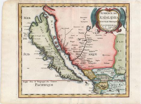
Audience de Guadalajara, Nouveau Mexique, Californie, &c. This map was first published in 1656 and introduced the so-called second Sanson model of California as an island. This depiction shows a small peninsula (Agubela de Cato) above the island, two bays along the island`s northern coast and two new place names, Tolaago and R. de Estiete. Sanson actually based this on information from the less well known map by Luke Foxe, but it was this map that influenced many other cartographers throughout the rest of the century. On the mainland there are new Indian tribes identified in the region of the R. del Norte, which flows southwest from a large inland lake. This example was published in Joannes Ribbius` very rare Dutch translation of Sanson`s L`Amerique en Plusieurs Cartes. The map was re-engraved for this edition, with only very minor differences from Sanson`s map of 1657. This is the first state of the Ribbius edition, prior to the addition of a grid of longitude and latitude. A nice impression on watermarked paper with attractive color. 7.9 W x 9.3 H Sanson, Nicolas 1683

New Mexico vel New Granata et Marata et California This copper-engraved map is on a full sheet (6.3 x 7.9"") with related English text below and on verso. It depicts California as an island on the second Sanson model with the addition of C de la Trinidad and P. California along the southern edge of the island. The Rio Grande is correctly shown flowing into the Gulf of Mexico while most maps of its time showed the river emptying into the Gulf of California. This is the first state of the map with page number 585 at upper right. Published in John Seller`s Geography Rectified. Watermarked paper with faint text show-through in the image, else fine. 4.4 W x 5.1 H Morden, Robert 1688

L`Ancien et le Nouveau Mexique, avec la Floride et la Basse Louisiane, Partie Occidentale This handsome map covers the region of present day southern California, Arizona, New Mexico, Texas and Mexico. Excellent detail, particularly of the Jesuit missions in Mexico and the Southwest, and of the numerous Indian tribes. The map locates San Diego, Santa Fe, Taos, Acapulco, Cabo St. Lucas and many towns along the Sea of Cortez and Baja Peninsula. Six distance scales at lower right. On watermarked paper with light offsetting. 13.5 W x 9.3 H Bonne, Rigobert 1780

Mexico & Guatemala This map of the southwest shows Texas as still a part of Mexico with Austins Colony noted. Sonora extends north into present-day Utah and is wedged between New Mexico and Upper California. The rivers Timpanogos and San Buenaventura run straight through the Great Basin into the Pacific. Insets include the Valley of Mexico and Guatemala. The map presents a great picture of the region prior to Texas declaring its independence. Original color with some light toning along the sheet edges, away from the map image. 11.7 W x 14.7 H Tanner, Henry Schenck 1834

Mexico This is an attractive representation of the present-day southwestern United States, Texas and Mexico. The map depicts the new state of Texas in its stovepipe configuration, bound by the Rio Grande on its western border. In Upper or New California, there is an American Fur Co. Depot on the eastern shore of L. Youta or Salt L.. The Great Spanish Road is shown from the Red River to Santa Fe, and then heading south through the length of Mexico. The map continues into Central America in an inset of Guatimala. Original outline color with light toning along the sheet edges, away from map image. Remnants of hinge tape on verso. 10.3 W x 14.5 H Hall, Sidney 1846

Mexico, California & Texas Early edition of this map featuring a vast California stretching to the Rockies, labeled as Upr. or New California. The rivers of the Gold Region are well shown and Ft. Sutter is located, but there is no mention of gold. Texas has an unusual shape here, with the panhandle extending north to the Arkansas River. New Mexico is a sliver of a territory between the oversized California, Texas, and Indian Territory, which starts at Red River and stretches north and to the west, over the Texas panhandle to the eastern edge of the Rockies. The map features a pre-Gadsden Purchase border between Mexico and the United States. There is good detail of the Californian missions and early forts throughout the Southwest. The Great Salt Lake, a Mormon settlement, and the Youtas all appear in the large California territory. Inset map of Central America at lower left. Finely engraved by Sidney Hall. A few minor spots and faint toning along the sheet`s edges. 10 W x 14.6 H Black, Adam & Charles 1848

Central America II. Including Texas, California and the Northern States of Mexico This excellent map covers the southwestern United States subsequent to Mexico losing the region in the Mexican/American War. Texas is shown at its largest extent with the panhandle extending well north up to Spanish Peaks. All of the Southwest and California are here noted as ""Nueva or Upper California."" Charles Fremonts first expedition up the Oregon Trail and through the Sierra Nevada is traced and there are several notations in the Great Interior Basin of California from that important exploration. Lake Tahoe makes an early appearance as Mountain L. The Great Spanish Track from Pueblo de los Angelos to Santa Fe is also noted. There is great detail throughout including forts, Indian tribes, and numerous interesting notations. This is an updated version of the map first issued in 1842; engraved by J. & C. Walker and published by Charles Knight. Original color with light toning along the edges of the sheet. 12.5 W x 15.5 H SDUK Society for the Diffusion of Useful Knowledge, 1849

Mexico, California and Texas This is the second, and most desirable, state of this fine steel-engraved map that was issued during a time of great transition in the region. After gold was discovered in California, the plate was re-engraved to include a vignette of gold panning and to locate the gold regions of California which are delineated through hand coloring. Texas is shown with its original state borders that include much of present-day New Mexico and extend into Colorado. Two other vignettes show Mexican peasantry and the ancient Mayan ruins at Uxmal. The very decorative border incorporates native plants of the region. Map drawn and engraved by John Rapkin, vignettes drawn by H. Warren and engraved by J. Rogers. Original outline color with light toning along the centerfold, a few tiny spots, and minor soiling along the sheet edges. 10 W x 13 H Tallis, John 1850

Messico o Nuova Spagna Dove si Possono Rintracciare i Movimenti di Cortes... This is an Italian edition of Kitchin`s map of the American Southwest and Mexico. California is labeled ""Nuovo Albione"" (New Albion) with no detail outside of a few coastal place names. The region of present-day Arizona and New Mexico is well delineated with numerous Indian villages and the locations of missions. The area from New Mexico to Louisiana is named ""Grande Spazio di Terra Incognita"" (Great Space of Land Unknown). The small Texas settlement of Cenis is near the ""Nuovo Regno ni Leon"" (New Kingdom of Leon). An inset shows Mexico City on the large Lake of Mexico. Finely engraved with a decorative title cartouche and compass rose. Issued folding on watermarked paper with light offsetting and a binding trim and short binding tear confined to the lower right blank margin. 11.2 W x 14.9 H Kitchin, Thomas 1795

Nova Hispania A handsome small map of Mexico and southern Texas, noting numerous rivers and towns, including Mexico City, Guadalajara, and Veracruz (Cruz). The R. de Palmas is approximately where the current border lies between Mexico and Texas, and the R. Escondido is believed to be the Nueces River. Adorned with a decorative cartouche incorporating the distance scale. French text on verso. There are a few tiny spots in the image, faint toning, and minor damp stains confined to the blank margins. 3.9 W x 5.2 H Hondius/Bertius, 1618

A Map of Mexico and the Republic of Texas This map features a young Republic of Texas and was issued in Niles & Pease`s History of Mexico & Texas. Settlements are confined to the eastern coast and include Houston, San Antonio, Galveston and Nacogdoches to name a few. The states of Mexico are delineated and the map extends to show a portion of Louisiana, Mississippi and Alabama. Backed in Japanese tissue to reinforce and repair numerous tears and cracks in the image with minimal loss of image primarily in Baja California. Trimmed to the neatline at left due to binding trim with a narrow margin at top right. Moderate offsetting and uneven toning. 12.8 W x 16.5 H 1838

Carte de la Californie Suivant I. la Carte Manuscrite de l`Amerique de Mathieu Neron Pecci... This sheet has five depictions of California that present a fascinating cartographic history of the region. It was one of ten maps compiled by Robert de Vaugondy for Diderot`s important encyclopedia and depicts the mapping of California by five important cartographers. The earliest map reproduces Neron Pecci`s manuscript map of 1604 showing the peninsula with a ragged coastline and place names derived from Cabrillo`s voyage of 1542-3. The second map is a detail from Sanson`s 1656 map showing the island of California with place names from the voyage of Vizcaino. Map three is from Delisle`s map of America of 1700 with the question of California`s insularity left open to interpretation. Next is Fra. Eusebio Kino`s important map of 1705 that finally ended that cartographic myth. It is based on his overland expedition from the mainland to the Sea of Cortez. Finally, map five is a portion of a Spanish map, showing the Jesuit explorations, that first appeared in Miguel Venegas` Noticia de la California in 1757, which is the first published history of California. This is an essential map for any California map collection. Issued folding with a hint of offsetting and a short fold separation has been professionally closed on verso. 11.5 W x 15.2 H Robert de Vaugondy, Didier 1772

Nova Hispania, et Nova Galicia Decorative map of the central and western coastal regions of Mexico, based on Ortelius. Mexico City is situated on a large lake below the elaborate title cartouche featuring the Royal Spanish Arms. Several gold and silver mines are located in the central region. A galleon and sea monster ornament the Pacific and armadillos walk across the scale of miles cartouche. This is a superlative example of Dutch cartography and a great example of the similarity between the work of Jansson and Blaeu. Here Jansson`s plate features a ship and sea monster with calligraphy in the Pacific, whereas Blaeu`s map lacks the calligraphy and embellished the area with two ships and a compass rose. Latin text on verso. Expertly remargined on all sides with light toning along centerfold and a separation at bottom that has been professionally repaired. There are three tiny holes just inside border at top left, one of which has been infilled. 13.7 W x 18.9 H Jansson, Jan 1638

Mexico sive N. Hispania Miniature map of Mexico and Central America including Cuba. Texas is identified as Florida while Florida is shown as Tegeste. Backed in paper to extend a narrow but adequate top margin and to reinforce a horizontal printer`s crease along the center of the map image. Remnants of hinge tape in top blank margin, away from the map image. 4 W x 4.8 H Duval/Beer, 1694

Carta Geografica del Messico o Sia della Nuova Spagna Beautifully engraved, Italian edition of Delisle`s map of Mexico, extending south to Costa Rica. There is good detail of towns, political divisions, rivers, and topography. The map includes the western end of Cuba and the southern tip of Florida with several place names noted. The large pictorial title cartouche features a pair of Noblemen, slaves, and a shepherd. A fine impression on watermarked paper with attractive color and a tiny hole east of Guadalajara. 12.9 W x 16.8 H Albrizzi, Girolamo 1750

Carta Esferica de las Costas y Golfo de Californias Llamado Mar de Cortes que Comprende Desde el Cabo Corrientes Hasta el Puerto de S. Diego... This rare sea chart was created for Guadalupe Victoria, the first president of Mexico shortly after Mexico gained independence from Spain. The map is a copy or a derivative of a map created in Spain by the Direccion de Hidrografia (Spanish Hydrographic Service). This map is one of a number of Spanish charts that were reissued in 1825 by the new Mexican government. The chart depicts Baja California (beginning at San Diego) and the eastern coastline of the Gulf of California south to C. Corrientes, which is just south of Puerto Vallarta. Soundings, rocks, shoals, and anchorages are noted along the coasts. Although the interior is left blank, the topography of the coastlines is illustrated by hachures. At top are three large insets depicting plans of the Port of Guaymas along the eastern coast of the Gulf of California, and the Bay of La Paz and Port of Pichilingue near the southern tip of Baja California. A bright, clean example that has been backed with Japanese tissue to help reinforce an archivally repaired tear that enters about 10"" into map at top. The bluish shadow that appears along the centerfold is caused by our scanner, and does not appear on the map. 34.2 W x 22 H Direccion de Hidrografia, 1825

Mexico This lovely bird`s-eye view of Mexico City depicts the center of the city as a large island in a lake surrounded by smaller islands with houses and fortifications and bridges. The view is based on Cortes` map of Tenochtitlan (Mexico City), which first appeared in 1524. The majority of the maps for Bertius` geographical treatise were engraved by Jodocus Hondius Jr. after Mercator. French text on verso. Excellent impression and color. 3.7 W x 5.2 H Hondius/Bertius, 1618

Plan of the Town, and Harbour of Puerto Vello This uncommon map depicts the important port city of Portobelo, known as a center for silver exporting. Several surrounding forts protect the city and its natural harbor. Soundings and anchorages are noted in the water. A ""Road to Panama"" is shown extending south. Engraved by John Gibson.We were not able to find any market comps for this map over the last 30 years. Watermarked paper with very generous margins, faint offsetting, and professional repairs to a few tiny holes along bottom neatline. 9.2 W x 12.9 H Speer, Joseph Smith (Capt) 1771

Plano de la Ciudad de Panama, y Su Arrabal This scarce plan was published by one of the most distinguished Spanish cartographers of the eighteenth century, Lopez de Vargas Machuca (1730-1802), who was Geographer to the King of Spain. This bird`s-eye plan depicts the fortress of Panama City, including some parts of the city outside the fortifications. A key at top right identifies 34 buildings and features, and a note below the title describes the location and gives a brief history of the city. A very uncommon map, as few Spanish maps were ever published. Original color on a bright sheet of watermarked paper with two minor printer`s creases at top right and a few small spots confined to blank margins. 15.3 W x 16.3 H Lopez de Vargas Machuca, Thomas (don) 1789

A Chart of ye West-Indies or the Islands of America in the North Sea &c. Being ye Present Seat of War Very uncommon map covering the present-day southern United States, Central America, the Caribbean and northern South America with an inset of Vera Cruz. The map contains fascinating notations concerning the movements of Spain`s wealthy galleons, such asThe Gallions & Flota usually joining at the Havana, ye whole Armada sails forth for Spain through this Gulf. This route took them into British waters off the coast of Carolina. Directions of trade winds, two compass roses, and rhumb lines make this a very attractive map. This is the later edition that was issued to show the theater for the War of Jenkins`s Ear. Relations deteriorated between Spain and England over logging issues in Honduras and the perception by the English that the Spanish were restricting their access to the slave trade in the West Indies. This friction was aggravated by a continuing dispute over the border between Spanish Florida and Georgia. Prime Minister Walpole declared war on Spain in October, 1739. A crisp impression on watermarked paper with a binding trim at lower left and a crease in the image also at lower left. Issued folding. Narrow margins at bottom and right. 11.3 W x 14.5 H Moll, Herman 1740

An Accurate Map of the West Indies. Exhibiting Not Only All the Islands Possess`d by the English, French, Spaniards & Dutch, but Also All the Towns and Settlements on the Continent of America Adjacent Thereto A handsome and fully engraved map covering the Southern U.S., Central America, the West Indies, and northern South America. It presents a fascinating configuration of Florida as wedge-shaped with a flat bottom. The chart is covered with interesting notations concerning the history of the region, territorial claims, and the Spanish gold fleet. The seas are fully engraved with ruled lines and an extensive array of trade-wind arrows. Compass rose and block-style title cartouche. A long notation gives sailing directions from Europe, Africa, Florida to Jamaica, and from Jamaica to the Windward Passage. It was published in the January 1740 issue of the Gentleman`s Magazine. Issued folding, now flat. The margins are trimmed close to the neatline at top, left, and right, with the right margin extended to better accommodate framing. Two tiny holes that are only visible when held to light appear along one fold. 11.6 W x 15.2 H Bowen, Emanuel 1740

An Accurate Map of the West Indies. Drawn from the Best Authorities, Assisted by the Most Approved Modern Maps and Charts, and Regulated by Astronomical Observations This handsome map covers the southeastern United States, eastern Mexico, Central America, the West Indies, and the northern part of South America. It is derived from Popple`s important map of the region. The British colonies in North America are confined east of the Appalachians with France in control of Louisiana. Many early forts and Indian tribal territories are located. There are several interesting notations concerning the history of the region, such as a notation concerning the southern boundary of the Province of Carolina, ""so that Fort St. Augustin as well as Georgia falls within these limits."" Trade winds and sea routes are marked throughout, including the course of the Spanish gold fleet from Old Spain and the return trip from Cartagena and Vera Cruz. The title cartouche is adorned with Native Americans and an incongruous lion (likely representing the British colonies). This is the first edition with No. 68 in bottom left margin. A dark impression with attractive color. Issued folding with a few tiny separations that have been archivally repaired and a tear that enters .6"" into image at top center that has been professionally repaired. 13.6 W x 16.5 H Bowen, Emanuel 1747

Charte von Westindien und einem Theile von Sudamerica Map of the Gulf of Mexico covering the region from Florida to northern South America. The map shows good detail of topography, the river systems and place names. A key at bottom identifies the possessions of the United States, Spanish, French, English, Dutch, Germans and Swedes. The map was issued by the Kunste un Industrie Compoires, and engraved by Kuhn. Watermarked paper with one small rust spot, light soiling, and narrow margins at left and right, as issued. 18.7 W x 27.3 H 1809

Carte Generale des Iles Antilles, d`une Partie du Mexique, des Etats-Unis & de l`Amerique Meridionale... This attractive chart covers the far southern United States, Mexico, Central America, the West Indies and the northern coastline of South America. The map is highly detailed along the coastlines with mainly rivers and topography noted inland. A key in the bottom corner identifies the possessions of the Spanish, French, English, Danish, Dutch and Swedish. Decorated by fancy tilting, four distance scales, and a keyboard style border. The embossed publisher`s stamp appears below the title. Dissected and backed on linen with just a few tiny, insignificant spots in the image. 14.7 W x 20.4 H Brue, Adrien Hubert 1821

Pas-kaart van de Zuyd-Kust van Espanjola met de Zee Kust van Nuevo Reyne de Granada This sea chart depicts the southern portion of Hispaniola, showing detailed navigational information along the coastline near Santo Domingo. At bottom is the northern coast of South America and the islands of Aruba and Curacao. The map is decorated by a sailing ship, two compass roses and radiating rhumb lines. A nice impression with a narrow top margin, light toning along the centerfold, and some color stains. 20.4 W x 23.2 H Keulen/Vooght, 1680

Les Isles de l`Amerique Connues sous le Nom d`Antilles, ou Sont les Isles de Cuba, St. Domingue et Jamaique les Lucayes, les Caribes, et celles du Vent There are a number of interesting historical and geographical notes on this map of the Caribbean. The map extends north to the Bahamas and the tip of southern Florida and encompasses the eastern shore of the Yucatan, parts of Central America, Panama and the northwest coast of South America. Between Florida and Cuba and the Bahamas, a reference to the Gulf Stream notes that is always flows north. Engraved by Herman van Loon with a handsome title cartouche and a small central compass rose. Included with the map is a full sheet of text describing the islands. Issued on watermarked paper with a few tiny spots and two professionally-repaired fold separations confined to the lower blank margin. 8.8 W x 13.2 H Fer, Nicolas de 1702

Dominia Anglorum in Praecipuis Insulis Americae ut sunt Insula S. Christophori Antegoa Iamaica Barbados nec non Insulae Bermudes vel Sommers A large and striking sheet that contains five charts describing the islands of St. Kitts, Antigua, Bermuda, Barbados and Jamaica. All of these maps were copied from separate maps made by Herman Moll in 1729. Each is finely engraved and meticulously detailed with its own compass rose, soundings, roads, forts, churches, topography and political divisions, as well as descriptive text and place name keys. The map has a second title in German: Die Englische Colonie-Laender auf den Insuln von America.... Minor soiling confined to the blank margins. 19.3 W x 21.8 H Homann Heirs, 1759
-
109182 item(s)/page