

Northern South America (Carta del Corso del Maragnone O sia del gran Fiume Dell` Amazzoni…), Rossi, Gazzettiere Americano, Rome, 1763. 12.5 x 8.5”. (BW) This interesting map of the Amazon region is based on astronomical observations conducted by Charles-Marie de La Condamine, a French explorer, geographer, and mathematician. After traveling to Ecuador in 1735 to test Isaac Newton`s hypothesis that the Earth was not a perfect sphere, La Condamine was unable to travel back to France directly due to insufficient funds. Instead, he traveled eastward down the Amazon River from 1743-44, and performed the first scientific exploration of the great river. This map depicts the Amazon River from its mouth in the Atlantic west to its tributaries in Colombia, Peru and Ecuador, with La Condamine`s route depicted with dotted lines. Issued folding. A fine impression with wide margins and just a hint of toning along centerfold. (A)
We found 109198 price guide item(s) matching your search
There are 109198 lots that match your search criteria. Subscribe now to get instant access to the full price guide service.
Click here to subscribe- List
- Grid
-
109198 item(s)/page
![Colombia, Venezuela, Panama, Costa Rica & Ecuador ([Lot of 2] Colombia [and] Carte des Pays Situes sur la Mer du Sud Depu](http://lot-images.atgmedia.com/SR/36385/2862480/379-2012510163317_468x382.jpg)
Colombia, Venezuela, Panama, Costa Rica & Ecuador ([Lot of 2] Colombia [and] Carte des Pays Situes sur la Mer du Sud Depuis Panama jusqu`a Guayaquil…), London, ca. 1779-1828. x ”. (HC) A) Colombia, by Sidney Hall, from A New General Atlas, published 1828, hand color (20.3 x 16.5"). This detailed map of Colombia includes Costa Rica, Panama, Venezuela, Ecuador and part of Brazil. It identifies key regions, towns, rivers and depicts mountains via hachure. The map is surrounded by a lovely keyboard style border. Ref: Kapp (Colombia) no.143. Condition: Wide margins with faint, scattered foxing. There is cello tape residue in upper blank margin, and a short tear in left blank margin far from map image. (B+) B) Carte des Pays Situes sur la Mer Du Sud Depuis Panama jusqu`a Guayaquil..., by William Robertson, from Histoire de l`Amerique, circa 1779, black & white (9.5 x 14.5"). This map stretches from Costa Rica to Colombia, to the tip of Peru in the south, and depicts the towns, rivers and a few roads. The map is adorned by a decorative floral title cartouche and a simple compass rose. Engraved by Benard. Condition: Folding, as issued, with a binding trim at left. There is light offsetting and two faint spots - one in blank area of map image at left and the second just entering map border at bottom. (B+) See description. ()

Guyana (Pas-Kaart van de Zee-Kusten van Guiana tusschen Cabo Noord en Rio Amano…), Keulen, Amsterdam, ca. 1700. 23.3 x 20.5”. (BW) Scarce sea chart centering on the bay at what is now Georgetown in Guyana, with an inset of the mouth of the Essequibo River and a plan of Fort Cajana. The map is detailed with soundings, currents, shoals and anchorages and embellished with rhumb lines, a sailing ship and compass roses oriented with north to the right. The striking title cartouche features two natives with their tame leopards. A dark impression with light offsetting and a few small abrasions and a tiny tear in the upper right blank margin. (+B)

Guyana, Suriname, French Guiana (Partie de Terre Ferme ou sont Guiane et Caribane. Augmentee et Corrigee Suivant les Dernieres Relations), Sanson/Mariette, Cartes Generales de Toutes les Parties du Monde…, Paris, 1656. 21.1 x 16”. (HC) This map of present-day Guyana, Suriname, French Guiana, and part of Brazil depicts several conjectural lakes and rivers. The mythical Lac Parime is prominently shown in a rectangular shape, with the fabled Manoa o el Dorado (City of Gold) on its western shore. The Orinoco River flows in a southern, rather than western, direction and connects to another conjectural lake, Cassipa Lacus. The map extends to include Trinidad, Tobago, and Isla de Margarita in the north and the mouth of the Amazon River in the south. A large, decorative cartouche fills the otherwise blank ocean. Ref: Pastoureau, Sanson V-A [92]. Original outline color on watermarked paper with light toning along centerfold and a spot of printer`s ink residue at bottom left. (+B)

Brazil (Le Bresil, dont la Coste est Possedee par les Portugais, et Divisee en Quatorze Capitanieries…), Sanson/Mariette, Paris, ca. 1662. 11 x 8”. (HC) This is a reduced version of Sanson`s important map showing the Portuguese possessions in Brazil. The coastal regions were divided by the Portuguese Crown into fourteen Capitaineries, or hereditary harbor offices. The holders of these grants, called donees (donatários), were responsible for their defense and development. There is also a fair amount of detail in the interior, along the major rivers. The mythical Lago de los Xarayes appears at left and the otherwise unknown interior is conveniently covered by the garland-style title cartouche. Minor soiling and an extraneous crease at left that has been pressed flat. There is a manuscript notation in upper blank margin. (+B)

Brazil (Accuratissima Brasiliae Tabula), Hondius/Schenk & Valck, Amsterdam, ca. 1708. 19 x 14.8”. (HC) Magnificent depiction of Brazil with north oriented to the right by a handsome compass rose. The map is inset with two regions of Dutch interest in the area: Baja de Todos los Sanctos and Pernambuco. The interior is bereft of geographical information except for largely imaginary rivers and forests. Instead the region is filled with dramatic scenes of the indigenous people, including warfare and cannibalism, and some curious wildlife. The hereditary captaincies established by the Portuguese are noted along the coastline. The decorative title cartouche is flanked by a native family and the seas are adorned with sailing ships, a sea monster and a compass rose. Wide margins with a few minor spots of foxing and light stains. (+B)

Brazil (Littora Brasiliae / Pascaert van Brasil), Renard/De Wit, Amsterdam, ca. 1715. 22.3 x 19”. (HC) This magnificent map of Brazil is primarily a sea chart with details confined to the coastline. Oriented with north to the left by two fine compass roses, it covers the Brazilian coastline from the mouth of the Amazon to the Rio de la Plata in what is now Argentina. A dramatic title cartouche that fills the interior is constructed of a montage of scenes showing Portuguese and Dutch explorers and missionaries, an Indian ceremony, mining, exotic animals and produce, etc. Rhumb lines cross the entire map, which is further embellished by four sailing ships. North is oriented to the left. This is the Renard edition of the map that was first published by Frederick de Wit, circa 1675. There is some minor soiling and small worm holes and tracks that have been professionally infilled near the centerfold, with a small amount of image in facsimile and a few tiny areas of loss of image. (+B)

Brazil (A New & Accurate Map of Brasil. Divided into its Captainships Drawn from the Most Approved Modern Maps & Charts…), Bowen, A Complete System of Geography…, London, ca. 1744. 16.8 x 13.8”. (HC) Copper engraved map with good detail along the coastal areas with scores of place names. The map covers the region between northern Paraguay and north to the mouth of the Amazon. A large inset of the Island of St. Katharine fills the blank ocean. In a lengthy note at bottom, Bowen states that he intentionally "omitted the imaginary Island of Ascension, upon the authority of Dr. Halley." The map includes several other notes, including an area said to "abound with Gold and Silver." (A)
![Brazil ([Lot of 3] Carte Reduite de la Cote du Bresil Comprise entre Porto Seguro et Pernambuco… [and] Carte Reduite de](http://lot-images.atgmedia.com/SR/36385/2862480/392-2012510163423_468x382.jpg)
Brazil ([Lot of 3] Carte Reduite de la Cote du Bresil Comprise entre Porto Seguro et Pernambuco… [and] Carte Reduite de la Cote du Bresil Comprise entre Pernambuco et Ciara [and] Carte Reduite de la Rade de Pernambuco…), Depot de la Marine, Paris, 1824-26. x ”. (BW) These detailed navigational charts outline the coast of Brazil and are based on an expedition tracked by M.M. Givry along the coast in 1819 and 1820. The charts cover the eastern coast from Porto Seguro in the south past Fortaleza (Ceara) in the north, noting Recife (Pernambuco), Salvador, and numerous other cities along the coast. The seal of the Depot de la Marine is engraved on each map. A. Carte Reduite de la Cote du Bresil Comprise entre Porto Seguro et Pernambuco, dated 1825 (23.8" x 35.5"). Condition: There are damp stains, a few archivally repaired tears at right, and a couple of tiny worm holes. B. Carte Reduite de la Cote du Bresil Comprise entre Pernambuco et Ciara/I>, dated 1826 (35.8" x 24"). Condition: There are some faint spots in the image and faint pencil marks in the Atlantic. The top left corner is chipped with slight loss of neatline. C. Carte Reduite de la Rade de Pernambuco et de ses Atterages Situes a la Cote Du Bresil… [on sheet with] Plan de la Rade de Pernambuco/I>, dated 1824 (36" x 24"). Condition: There are a couple of extraneous creases with a short tear along one crease at top and some faint spots. The two maps are joined together on verso with archival tape. All maps have light soiling and are trimmed to the neatlines. See description for more details. (B)

Eastern Brazil (Capitaniae de Cirii, et Parnambuco), Jansson, Atlas Novus, Amsterdam, ca. 1657. 21.5 x 17.5”. (HC) This rare chart of the Captaincies of Ceara and Pernambuco extends from the Rio Formosa to the Rio Estremo and is centered on the Rio de San Francisco. Much information is derived from maps drawn for the Dutch West Indies Company during its bid to rest control of the region from the Portuguese. North is oriented to the right of the chart by a compass rose. It is finely adorned with two cartouches and sailing ships. Lovely original color with light offsetting, two 1/2" centerfold separations towards the top, and a couple of minute cracks caused by the oxidation of the green pigment. There is a tear that just enters map border at bottom that has been closed with archival materials. (+B)

Salvador, Brazil (Aenwysinge van de Stadt Salvador, ende de Baya de Todos Los Santtos), Hondius, Amsterdam, ca. 1624. 16.5 x 11.5”. (HC) This rare map of Salvador and Baia de Todos os Santos (Bay of Saints) ) is a very early depiction of the Dutch attack and capture of the city of Salvador in May 1624. Salvador, then the capital of Brazil, was a strategic port under Portuguese control. The Dutch, determined to seize control of Brazil, formed the West India Company in 1621 and sent a large expedition to Brazil. On May 8, 1624, the Dutch fleet under the command of Admiral Jacob Willekens and Vice Admiral Pieter Heyn arrived in Salvador and attacked the city. The Dutch succeeded in capturing the city, although the Portuguese regained control less than a year later. This map depicts the city of Salvador and its fortifications, with the 26 Dutch ships advancing on the city. The remainder of the coastline is sparsely engraved with a few small towns, trees, and hills. The map is oriented with north to the left and includes an inset bird`s-eye plan of Salvador, with 16 locations identified in a key in the title cartouche. A later edition of the map shows fewer ships attacking the city, perhaps illustrating a later Dutch attack. The imprint at lower right credits Henricus Hondius in The Hague. It is unclear if this is the well-known Amsterdam publisher or the lesser-known engraver and printer from Delft who worked during the same period. Light soiling with a few tiny tears along centerfold that have been repaired with archival materials. There is a small hole in right blank margin that has been closed on verso with old paper, and a tiny worm hole near I. Pycco. (+B)

Paraiba, Brazil (Afbeeldinghe van Pariba ende Forten), Commelin, Amsterdam, ca. 1651. 14 x 10.8”. (HC) This bird`s-eye map shows the region of Paraiba and Portuguese fortifications at the mouth of the River Paraiba. The scene of the Dutch attack on the region is illustrated with the Dutch fleet and the defending Portuguese armies. Watermarked paper with one faint spot in center, and faint damp stains in blank margins, not affecting image. (A)

Central South America, Paraguay (Paraguay, o Prov. de Rio de la Plata cum Regionibus Adiacentibus Tucuman et Sta. Cruz de la Sierra), Blaeu, Amsterdam, ca. 1640. 19 x 14.8”. (HC) Superb map of the region including the Paraguay River basin and the Peru-Chilean coast with Lake Titicaca. The Rio de la Plata is boldly shown with many large islands in the broad river. The mythical Lago de los Xarayes is featured on the map, which was believed to connect the Rio de la Plata and Amazon River systems. Several towns are named including R. Ianeiro, S. Paulo, Buenos Ayres, Corduba, Medoca, Arica, Potosi and Cusco. A large decorative title cartouche incorporates the distance scales, while a smaller cartouche features an armillary sphere. A fine, large compass rose with fleur-de-lys also adorns the sheet. Dutch text on verso. Old color and wide margins with light damp stains that just enter map border at bottom & a couple tiny tears in wide original margins, none affecting the map. (+B)

Argentina and Uruguay (Plata Americae Provincia), Wytfliet, Histoire Universelle des Indes Occidentales et Orientales, Louvain, ca. 1598. 11.5 x 9”. (BW) This fascinating map is from the first printed atlas relating exclusively to America. The map provides graphic details of the Rio de la Plata and its tributaries based on early Spanish explorations in search for the Silver Mountain of the White King and the lost city of Los Cesares. Sebastian Cabot`s ill-fated settlement at S. Espirito is shown at the confluence of the Carcarana and Parana Rivers and Cabeza de Vaca`s settlement of Assumption (Asunción) is located on the banks of the Rio Lepeti. The settlement on the R. de Buenos arres, first established in 1536, is not noted on this map as it had been abandoned after Indian attacks in 1539 and 1541. Slightly uneven impression with an expertly repaired centerfold separation and printer`s ink residue in upper-right corner. (+B)

Peru (Peru), Keere, Caert-Thresoor, ca. 1609. 4.8 x 3.5”. (BW) An interesting miniature map of Peru oriented with north at right, and extending into Ecuador, Bolivia and Chile. Major cities and villages are noted, including Quito, Lima, Cuzco and La Paz. A simple strapwork cartouche and moiré-patterned sea adorn the map. Dutch text on verso. Ref: King (2nd ed.) pp. 80-82. A few faint spots, marginal soiling and two minute tears in top blank margin. There is some show-through of text on verso. (+B)

Peru (Peru), Gerritsz/De Laet, ca. 1633. 14 x 11”. (HC) This great map is a foundation map for later Dutch maps of Peru. The map is the work of Hessel Gerritsz, one of the truly important Dutch cartographers of the 17th century. Most of his work was only done in manuscript and these maps, published by De Laet, are the only Gerritsz maps available to the collector today. The map vividly depicts the mountainous region and the large Titicaca lake, which is dotted with islands. A splendid strapwork title cartouche and compass rose adorn the map. Watermarked paper with light surface soil and a crease along right side, now pressed. There are two minute worm holes only visible when held to bright light. Remargined at bottom and expert repairs of a couple tiny marginal tears. (+B)

Chile (Chili), Gerritsz/De Laet, ca. 1630. 14 x 11”. (BW) This bold map covers Chili, from Puente de Vetes in the North to Cap de Diego Gallego in the south with north to the left. Beautiful title cartouche, scale of miles, map key and a large compass rose make this a very attractive sheet. Hessel Gerritsz`s cartography of South America laid the foundation for many other cartographers. Johannes de Laet, the director of the Dutch West India Company, was privy to the latest topographical knowledge. There are a few worm tracks and wormholes in the lower blank margin and the sheet is lightly toned. (+B)

Western South America (Map of the Valley of the Amazon to Accompany Lt. Herndon`s Report), Herndon, Exploration of the Valley of the Amazon…, Washington D.C., ca. 1853. 24 x 18”. (PC) This is one of three maps that accompanied Herndon`s report, Exploration of the Valley of the Amazon. In 1851, Lieutenant Herndon was commissioned to lead the first American expedition of the Valley of the Amazon, "to explore the Amazon, to sound its streams and to report as to their navigability." The exploration and resulting report were made under the direction of the U.S. Navy Department. Herndon journeyed through parts of Peru, Bolivia and Brazil for nearly a year and went on to become the captain of the ill-fated Central America, which sank in 1857 with a load of gold and newly minted gold coin from the Carson City mint. The gold, valued at more than a billion dollars, was recovered in a deep water project completed in 1989. This seldom seen map details the basin and valley of the Amazon River. The range extends from the Pacific in Peru and Ecuador to the Atlantic and the mouth of the Amazon at the I. Marajo. The watershed is shown in great detail and the tracks of both Herndon and Lt. Lardner Gibbon, who was ordered to explore a different area of the Amazon, are also depicted. At top is a view of a Vertical Section of Route from Callao to Para. Drawn by H.C. Elliot. The map folds into the original covers, titled Herndon`s Valley of the Amazon Maps. Part 1. Covers are brown cloth-covered boards, with decorative embossing and gilt title. Map of the Rivers Huallaga, Ucayali & Amazon… was originally included in the covers, but has been removed. Folding, as issued, with uneven toning, and still attached to original covers. There are several fold separations, with very small areas of loss in blank areas of map image at two fold intersections. Covers are faded in areas with spots on front cover and a 1" tear along spine. (+C)

Western South America, Peru (Carte Particuliere du Perou, Plan de la Ville de Lima, Description de Quelques Plantes, Animaux, & Machines du Pays…), Chatelain, Amsterdam, ca. 1719. 14.5 x 19”. (BW) This interesting folio sheet contains two maps and two engravings surrounded by panels of French text. The top map covers the northwest coast of South America from Panama to northernmost Chili, with detail of towns, rivers, and mountain ranges. The map is flanked by two engravings depicting the people, tools, animals and plants of the region. At bottom is a bird`s-eye plan of Lima showing its fortifications. Folding, as issued, with wide margins. There is a tiny worm track along fold in bird`s-eye view at bottom. Otherwise clean and bright. (+B)
![Southern South America (Fretum Magellanicum, und dessen Eigentliche Beschreibung…), Bry, Grand Voyages Part IX, [1601].](http://lot-images.atgmedia.com/SR/36385/2862480/407-2012510163535_468x382.jpg)
Southern South America (Fretum Magellanicum, und dessen Eigentliche Beschreibung…), Bry, Grand Voyages Part IX, [1601]. 11.8 x 6.5”. (BW) This small copper engraved map illustrates the voyages of Sebald de Weert and Olivier van Noordt through the Straits of Magellen in 1598. It features renderings of the native inhabitants taken from the illustrations to De Weert’s voyage and an interesting depiction of a penguin and a giant snail. The map is further adorned with a compass rose orienting the map with south at the top, and two strapwork cartouches. Ref: Garratt [TMC-9] pp. 2-11, no.G13. Wide margins with just a hint of toning. (A)

Southern South America (Destroit de Magellan, Terre, et Isles Magellanicques, &c.), Sanson/Mariette, L`Amerique en Plusieurs Cartes…, Paris, ca. 1665. 9.5 x 8”. (HC) This attractive, small map shows the tip of South America with Tierra del Fuego. It illustrates the Strait of Magellan, Le Maire Strait and the mythical Destroit de Browers. Ref: Pastoureau, Sanson II C. Old color and wide margins with toning along centerfold and a few faint spots. (+B)
![Southern South America ([Lot of 2] Plan de la Ville de Buenos-Ayres [and] Argentine Republic, Chili, Uruguay & Paraguay),](http://lot-images.atgmedia.com/SR/36385/2862480/410-2012510163554_468x382.jpg)
Southern South America ([Lot of 2] Plan de la Ville de Buenos-Ayres [and] Argentine Republic, Chili, Uruguay & Paraguay), Paris, ca. 1757-1855. x ”. A. Plan de la Ville de Buenos-Ayres, by Jacques Bellin, from Histoire Generale des Voyages, circa 1757, black & white (10.8 x 7.0"). This early plan of Buenos Aires is laid out in blocks with unnamed streets. A few important buildings are identified and the fort is prominently shown on the coast with its ramparts well delineated. Embellished with a large compass in the bay and a rococo-style title cartouche that incorporates a distance scale. Condition: Nice dark impression with faint offsetting and a few tiny spots. Issued folding. B. Argentine Republic, Chili, Uruguay & Paraguay, by Joseph Hutchins Colton, from the General Altas, dated 1855, hand color (11.8 x 14.5"). This attractive map displays Argentina, Chile, Uruguay and Paraguay. Political boundaries are delineated along with the locations of numerous towns, rivers, lakes and topography. Just to the south of Argentina is a note stating that the area is "inhabited by wandering tribes of Indians." While the map is dated 1855, the 1857 edition of the General Atlas is the only one to use this plain border. Condition: There is a small 1" tear in the upper portion of the image that has been closed on verso with archival tape, and there are a few minor extraneous creases and light even-age toning. See descriptions. (+B)

Southern South America (Chili la Terra Magellanica coll` Isola della Terra del Fuoco), Zatta, Atlante Novissimo, Venice, 1785. 12.3 x 16.3”. (HC) This Italian map covers present-day Chili and Argentina with an inset of Tierra del Fuego and the Straits of Magellan. There is good detail of topography, rivers and place names. Decorated by a simple scroll title cartouche. Wide margins on watermarked paper with several extraneous creases and a light damp stain at lower left and right. (+B)
![Tierra del Fuego ([Lot of 4] Extremite Meridionale de l`Amerique [and] [4 Coastal Views] [and] View of the Indians of Terra D](http://lot-images.atgmedia.com/SR/36385/2862480/412-2012510163559_468x382.jpg)
Tierra del Fuego ([Lot of 4] Extremite Meridionale de l`Amerique [and] [4 Coastal Views] [and] View of the Indians of Terra Del Fuego... [and] A Man of Christmas Sound, Tierra del Fuego…), Paris, ca. 1784-88. x ”. (BW) A) Extremite Meridionale de l`Amerique, by Rigobert Bonne, from Atlas Encyclopedique, published 1787-88 (13.5 x 9.3"). This copper-engraved sheet of Tierra del Fuego is centered on a large compass rose. The map details the treacherous track through the Straits of Magellan. Five insets show bays, small groups of islands, soundings, rocks, and anchorages. Engraved by Andre. Condition: Wide margins with faint offsetting and light toning along centerfold. There are a few minute worm holes in upper blank margin, far from map image. B) [4 Coastal Views], engraved by Walker, from A New Authentic and Complete Collection of Voyages Round the World, published by Alexander Hogg, 1784 (13.2 x 8"). Condition: One small, insignificant spot in blank area of view near bottom. There are three minute holes in upper blank margin and binding holes in lower blank margin. C) View of the Indians of Terra Del Fuego, with a Representation of a Hut, and their Domestic Mode of Living, engraved by Morris, from A New Authentic and Complete Collection of Voyages Round the World, published by Alexander Hogg, 1784 (13 x 8"). Condition: A few light spots, primarily confined to blank margins. There are three minute holes in upper blank margin and binding holes in lower blank margin. D) A Man of Christmas Sound, Tierra del Fuego [on sheet with] A Woman of Christmas Sound, Tierra del Fuego, from A New Authentic and Complete Collection of Voyages Round the World, published by Alexander Hogg, 1784 (13.3 x 8.8"). Condition: There is a tiny bit of paper glued to neatline at bottom. There are three minute holes in upper blank margin and binding holes in lower blank margin. See description. (+B)

Atlantic Ocean (H. Benzos Scheep-Togt uit Italie over Spanje na de Westindize Eylanden, en Kusten van`t Zuider America), Aa, Leiden, ca. 1706. 9 x 6”. (BW) This lovely small map of the Atlantic Ocean depicts the route of explorer Hieronymus Benzo, who traveled from Spain to the Americas, and back to Italy from 1541-56. The map includes large portions of North America, South America and Africa. Many of the cartographic myths at the turn of the eighteenth century are also shown, including a large inland lake in the Carolinas, an inaccurate depiction of the Great Lakes, and Parime and Xarayes Lakes (here unnamed) in South America. The map is adorned with a vignette of the European explorers and natives. Issued folding with light offsetting and a few spots of printer`s ink residue. (+B)
![Canary Islands (Isles Canaries), Duval, Le Monde ou la Geographie Universelle, Paris, [1672]. 4.8 x 3.8”. (HC) This min](http://lot-images.atgmedia.com/SR/36385/2862480/418-2012510163636_468x382.jpg)
Canary Islands (Isles Canaries), Duval, Le Monde ou la Geographie Universelle, Paris, [1672]. 4.8 x 3.8”. (HC) This miniature map of the Canary Islands depicts a few towns and topographical features. Pierre Duval was Nicolas Sanson`s nephew and pupil. He published a wide range of atlases and individual maps including a fine miniature world geography with many of the maps based on Sanson. Ref: King (2nd ed) pp. 132-135; Pastoureau, Duval XI C. Watermark of a crown with light toning along centerfold and in blank margins. (A)

Iceland (Islanda), Porcacchi, L`Isole piu Famose del Mondo, ca. 1576. 5.5 x 4”. (HC) This wonderful little map of Iceland shows the island prior to when any actual surveys were completed. It reflects very sketchy knowledge of the island, which is shown surrounded by many smaller islands. The minutely engraved map features delightful depictions of topography and elaborate cities. Mount Hecla is shown as a flaming mountain and named Mons Helafiel. Several icebergs are shown floating off the coast. The map is oriented by a simple compass and adorned with a deftly engraved cartouche. Engraved by Girolamo Porro and printed on a full sheet (7 x 10.3") of Italian text. Ref: King (2nd Ed.), p. 57-59. A couple of unobtrusive spots with marginal soiling. (+B)
![Iceland (Island), Mercator/Hondius, Atlas Minor, Amsterdam, [1607]. 7.5 x 5.3”. (HC) Delightful small map of Iceland, w](http://lot-images.atgmedia.com/SR/36385/2862480/424-201251016377_468x382.jpg)
Iceland (Island), Mercator/Hondius, Atlas Minor, Amsterdam, [1607]. 7.5 x 5.3”. (HC) Delightful small map of Iceland, which is shown filled with mountains including the volcanic Hecla. The sea is stipple engraved and includes a spouting sea monster. Delicately engraved strapwork title and distance scale cartouches adorn the map. This is from the first edition, with Latin text on verso. Marginal soiling with a few tiny tears and light creases in blank margins. Manuscript page number and cardinal directions in blank margins. (A)

Iceland (Tabula Islandiae Auctore Georgio Carolo Flandro), Hondius/Blaeu, Amsterdam, ca. 1644. 19.6 x 15”. (HC) This handsome copper engraved map of Iceland was based on information from a Dutch navigator named Joris Carolus in about 1620. The map shows the influence of both versions of Bishop Gudbrandur`s previous maps, a coastline resembling the Ortelius version, and Mercator`s selection and spelling of many place names. The island`s topography is dominated by huge mountains and volcanoes and its shoreline is a rugged labyrinth of fiords. It is richly embellished with title and distance scale cartouches, compass roses, rhumb lines, a sailing ship and two sea monsters. The cartouche features two winged sprites, an important symbol in Icelandic and Norse mythology. Along with elves and dwarves, sprites were magical beings who aided the gods. The map was first issued by Jodocus Hondius and then re-issued by Willem Blaeu with his imprint. It became the prototype for the mapping of Iceland and its influence did not wane until the mid-18th century. Latin text on verso. Nice impression and color with just a few minor spots and faint show through of text on verso. (A)

Arctic & Scandinavia (Septentrionalium Partium Nova Tabula), Ruscelli, La Geografia di Claudio Tolomeo Allessadrino…, Venice, ca. 1562. 9.5 x 7”. (BW) This is a reduced version of the landmark Zeno map showing the mythical islands in the North Atlantic and small coastlines of Labrador (Estotiland) and possibly Newfoundland (Drogeo). Frisland is depicted in considerable detail, with many place names indicated. The only cartographic difference between this and the woodcut map published by Zeno is that there is no land bridge between Greenland and Scandinavia on this edition. The plate mark runs off the sheet at top indicating that two maps were printed together, then separated for inclusion in the atlas. There is one surviving full, uncut sheet that reveals the sister map was the Ptolemy world. First state with Latin text on verso. In 1558, Nicolo (the Younger) Zeno claimed to have discovered a 14th century manuscript recording a voyage made by his ancestors Nicolo and Antonio. According to the text, in the year 1380 a storm swept the Zenos into the North Atlantic where they found a group of unknown lands named Frisland, Estotiland, Estland, Icaria, and Drogeo. As a result, maps throughout the 16th century continued to show these fictional islands, especially Frisland. Ref: Burden no.29; Ginsberg no.18; Manasek no.19. Faint toning in the centerfold and marginal soiling. (A)
![Arctic & Scandinavia (Septentrionalium Regionum Descriptio), Ortelius/Galle, Il Theatro del Mondo, Antwerp, [1577]. 4.3 x](http://lot-images.atgmedia.com/SR/36385/2862480/427-2012510163719_468x382.jpg)
Arctic & Scandinavia (Septentrionalium Regionum Descriptio), Ortelius/Galle, Il Theatro del Mondo, Antwerp, [1577]. 4.3 x 3”. (BW) Delightful miniature map based on Ortelius` important map of the Arctic regions and the North Atlantic with the mythical islands of Drogeo (unnamed) and Friisland. Greenland is shown as a large island separated from the Pigme Ihio Habitant (land in habited by pigmies). This is the first edition of the miniature map which is a reduced version of the folio by Ortelius in 1570. On a full sheet (5.5 x 7.5") of Italian text. On the recto of this sheet is the map of Livonia. Ref: Burden no.127; Ginsberg no.27. Small printer`s creases in the lower right portion of the image, else fine. (A)
![Europe ([Europa Regina]), Munster, Cosmographia, Basel, ca. 1588. 6.5 x 10”. (HC) This is one of the most famous of car](http://lot-images.atgmedia.com/SR/36385/2862480/428-2012510163722_468x382.jpg)
Europe ([Europa Regina]), Munster, Cosmographia, Basel, ca. 1588. 6.5 x 10”. (HC) This is one of the most famous of cartographic oddities, showing Europe in the shape of a woman. The representation of Europa Regina or Queen of the World was first drawn by Jonannes Bucius in 1537. This simplified version appeared in several editions of Munster`s Cosmography from 1580 onwards. West is shown at top with Spain forming the crown and head, France and Germany the neck and bust, Bohemia the heart, Italy the left arm holding an orb (Sicily) and Denmark the right arm holding a scepter with Britain as the flag. The remainder of the figure is a flowing robe with Greece and Russia at the feet. It has been argued that instead of a woman, the map represents Charles V of Spain, modeling a Europe that had Spain as its crown, or that it symbolizes a Habsburg-dominated Europe. Whatever the source, this is an extraordinary example of the art of mapmaking. German text on verso. Ref: Tooley (MCC-1) no.6, Plt. V; Manasek no.3.21. Light show-through of text on verso and marginal soiling. (+B)
![Europe (Romani Imperii Imago), Mercator/Hondius, Atlas Minor, Amsterdam, [1607]. 7.5 x 6”. (HC) Superb map of the Roman](http://lot-images.atgmedia.com/SR/36385/2862480/429-2012510163725_468x382.jpg)
Europe (Romani Imperii Imago), Mercator/Hondius, Atlas Minor, Amsterdam, [1607]. 7.5 x 6”. (HC) Superb map of the Roman Empire covering most of Europe, Northern Africa, and the Near and Middle East. The map is richly decorated with two strapwork cartouches and two containing portraits. The cartouche in the lower section of the map contains a brief account of Roman dominion. This is from the first edition, with Latin text on verso. There is a printer`s crease at top left and a few manuscript ink notations on map. Several small chips and tears in blank margins have been expertly repaired, and the top margin has been extended to better accommodate framing. Manuscript page number and cardinal directions in blank margins. (+B)

Europe (Europ, and the Cheife Cities Contayned therein Described; with the Habits of Most Kingdoms Now in Use), Speed, A Prospect of the Most Famous Parts of the World, London, 1626. 20 x 15.5”. (HC) This is one of the most beautiful carte-a-figure maps of Europe, surrounded with vignettes on three sides. The upper frieze has eight bird`s-eye views of London, Paris, Rome, Constantinople, Venice, Prague, Amsterdam and Lisbon. The side borders contain the costumes of the noblemen and women of ten European nations. The map shows the well-detailed but fictitious island of Frisland just off the coast of Iceland, and the seas are alive with sea monsters and ships. Beautifully engraved by Abraham Goos and published by George Humble between 1627-32. Related English text on verso. Ref: Shirley (BL Atlases) T.SPE-2a no.4. Attractive color on watermarked paper with light show-through of text on verso, minor soiling, and professional paper repairs along centerfold. There is a small repaired hole in the Gulf of Venice with minor loss of image. Expertly remargined on all four sides with a small amount of border in top left corner in facsimile. (B)

Europe (Europa Recens Descripta), Blaeu, Amsterdam, ca. 1645. 21.8 x 16.3”. (HC) This classic map of Europe is presented in the carte-de-figures style with vignettes on three sides. The upper frieze has nine bird`s-eye views of Amsterdam, Prague, Constantinople, Venice, Rome, Paris, London, Toledo and Lisbon. The side borders contain the costumes of the noblemen and women of ten European nations. The map is embellished with sailing ships, sea monsters, bears and Neptune riding a dolphin and holding his trident. A beautiful map produced at the height of the Golden Age of Dutch mapmaking; it was included in the first volume of Blaeu`s magnificent atlas. French text on verso. Ref: Goss (Blaeu) no.4, p.30. Lovely color with a professionally repaired centerfold separation that enters 3" into map image at bottom and a couple of tiny tears in blank margins, one of which just touches neatline at right. There are a few faint spots and marginal soiling. Remnants of hinge tape on verso. (+B)

Europe (Carte d`Europe Dressee pour l`Usage du Roy…), Delisle/Covens & Mortier, Amsterdam, 1739. 23.3 x 18.8”. (HC) This densely engraved map of Europe depicts towns, roads, rivers, lakes, counties, etc. The decorative title cartouche is surmounted by the French Royal coat of arms. Engraved by Johannes Condet. The Latin title above neatline, Europa Accurate in Imperia, Regna, Status & populos Divisa, ad Usum Ludovici XV Galliarum Regis, dedicates the map to King Louis XV. Light impression, original outline color with a few faint spots and a couple of short tears in blank margins, far from map image. (+B)
![Europe (Europe), Bossuet, Discours sur l`Histoire Universelle…, Amsterdam, [1755]. 6.5 x 5”. (HC) This handsome m](http://lot-images.atgmedia.com/SR/36385/2862480/434-2012510163752_468x382.jpg)

Europe (Subject Nationalities of the German Alliance…), ca. 1917. 36.3 x 27”. (PC) This unusual thematic map documents the population and nationalities of the Central Powers (Germany, Austria-Hungary, Bulgaria and the Ottoman Empire) engaged in World War I. It locates Jewish Colonies in Palestine and the Expropriations of the German Ansiedelungs Kommission (Prussian Settlement Commission), one of Germany`s efforts to Germanize Polish territories. Below the title is a quotation from the Allies in response to President Wilson`s note on December 19th, 1916 reading "The civilised [sic] world knows that the aims of the Allies include the reorganization [sic] of Europe, guaranteed by a stable settlement, based alike upon the principle of nationalities and on the right which all peoples, whether small or great, have to the enjoyment of full security and free economic development." Printed by the Dangerfield Printing Co. and published by Stanford`s Geographical Establishment, London. There are a numerous small splits at fold intersections and a few small edge tears, one of which extends 0.75" past the neatline. (B)
![Britain (Isles Britanniques), Bossuet, Discours sur l`Histoire Universelle…, Amsterdam, [1755]. 6.5 x 5”. (HC) Th](http://lot-images.atgmedia.com/SR/36385/2862480/441-2012510163828_468x382.jpg)
Britain (Isles Britanniques), Bossuet, Discours sur l`Histoire Universelle…, Amsterdam, [1755]. 6.5 x 5”. (HC) This little map of the British Isles extends to include the Fero and Shetland Islands, as well as part of the European coastline. It is based on Sanson`s pocket atlas map and includes a considerable amount of information for such a small map. (+A)

British Islands (Insula Sacra; Vulgo Holy Iland; et Farne), Blaeu, Atlas Nuevo, Amsterdam, ca. 1660. 18.3 x 15.3”. (HC) This attractive map portrays Holy and Farne Islands off the coast of Northumberland. Farne Island is shown with the Tower in a fortification. On Holy Island, the Old Fort, an abbey, and the King`s Bridge are shown. The mainland is devoid of detail except for a few cities and castles. The map is decorated with a strapwork title cartouche and a beautiful rendering of the royal coat of arms. Spanish text on verso. Original color and wide original margins on watermarked paper with some offsetting and toning in the image, primarily along the centerfold and in the cartouche. There is an archivally repaired tear in bottom left corner, not affecting map. (B)

England (Wigorniensis Comitatus et Comitatus Warwicensis; nec non Coventrae Libertas. Worcester, Warwik Shire and the Liberty of Coventre), Blaeu, Atlas Novus, Amsterdam, ca. 1662. 20 x 16.3”. (BW) This map of Worcester and Warwickshire was first published in Blaeu’s Atlas Novus in 1645, and was one of many English county maps included in Volume IV. Blaeu based this work on the Theatre of the Empire of Great Britaine published by his English colleague John Speed in 1611. The map is peppered with tiny villages and forests, and includes the royal coat of arms and the coats of arms of nobility in the counties. Latin text on verso. Nice strong impression with a centerfold separation that enters 1" into map image at top and some light toning along the centerfold. Remnants of hinge tape on verso. (+B)

England (The Road From Bristoll to Worchester…), Ogilby, Britannia, London, ca. 1675. 17.5 x 12.3”. (HC) Attractive strip-style map covering the road from Bristol to Worchester in six strips totaling 62 miles. Each of the six panels has at least one decorative compass rose to orient the traveler. The title cartouche is surrounded by fruit and vegetation, representing this rich agricultural region, and the royal coat of arms. Ref: Shirley (BL Atlases) T.OGIL-4a no.59. Light toning and a hint of offsetting, else very good. (+B)
![Southeastern England (Warwicum Northampton, Huntingdon Cantabr etc.), Mercator/Hondius, Atlas Minor, Amsterdam, [1607]. 7.5 x](http://lot-images.atgmedia.com/SR/36385/2862480/445-2012510163841_468x382.jpg)
Southeastern England (Warwicum Northampton, Huntingdon Cantabr etc.), Mercator/Hondius, Atlas Minor, Amsterdam, [1607]. 7.5 x 5.3”. (HC) Appealing small map of southeastern England including London, Salisbury, Oxford, Cambridge, Leicester and Norwich and the Isle of Wight. The map is filled with minutely engraved detail and is graced with two strapwork cartouches and a moiré patterned sea. This is from the first edition, with Latin text on verso. Marginal soiling. Manuscript page number and cardinal directions in blank margins. (A)

London, England (Regionis quae est circa Londinum … Ausfuhrliche Geographische Vorstellung der Gegend um London…), Homann Heirs, Nuremberg, 1741. 22.5 x 20”. (HC) This very detailed map centered on London was originally produced by Thomas Bowles. It covers the vicinity from Maidenhead to Rochester. The map extends to include P. High Wickham, Chelmsford, Bishops Stratfort, and below Rochester. The lower quarter is a bird`s-eye view of London and Westminster from Southwark from across the Thames, which is densely filled with boats and ships of all description. The legend uses icons to locate towns, market towns, parish churches, gentlemen`s houses, castles, wind and water mills, and villages. Ref: Howgego no.88. Toned with a few tiny spots of foxing and an archivally repaired centerfold separation that enters 1/2" into map image at bottom. The map has been fully remargined and has a printer`s crease extending through most of the image to the left of the centerfold. (B)

London, England (Vue de l`Hotel du Lord Maire, qui Comprend la Façade, et le Cote Occidental de Londres), ca. 1760. 15.5 x 11”. (HC) This lovely view shows the famous Lord Mayor`s coach driving through London. The Lord Mayor`s coach is famous for its role in the Lord Mayor`s Show, which is one of the longest established annual events in London, dating back to 1535. Engraved by Balth. Fraderic Leizelt. Watermarked paper with a damp stain that just enters map image at top right, and two small holes in left blank margin, far from image. (+B)

London, England (Wyld`s New Plan of London), Wyld, 1870. 37.3 x 21.3”. (HC) This attractive map of London displays both title and distance scale in English, French and German and the border shows vignettes of various landmarks including St. Paul`s Cathedral, House of Parliament, London Bridge, Buckingham Palace, and the Crystal Palace (site of the Great Exhibition). Dissected and backed with linen. Folds into paper covered boards. There is some light toning and staining along with a few areas of minute loss. Boards are worn with chips to paper labels. (B)

London, England (New Map of London with the Recent Improvements), Reynolds, London, 1872. 28.8 x 19”. (HC) This handsome late 19th century map of London shows streets, canals, public buildings, docks, bridges and parks. The River Thames is shown flowing through the city from Limehouse Reach to Chelsea Reach. Includes an index to streets along with a list of bankers, public offices, and cab fares between locations. Folds into brown covers measuring 4 x 6". There are a few small stains in the left portion of the image and a few tiny fold separations. The index is toned with fold separations, and the covers are lightly worn with a few small stains. (+B)

Bedford, England (Bedford Shire), Morden, Britannia, London, ca. 1722. 15.8 x 12.5”. (BW) This county map of Bedfordshire shows the early road system with the city of Bedford located at center along the Great Ouse river. The map is divided into Hundreds and displays interesting detail including the locations of buildings, rivers, bridges and parks. There is an attractive drape-style cartouche and three distance scales. Sold by Abel Swale, Awnsham & John Churchil. Morden was one of the first English cartographers to show longitudes measured from the meridian of St. Paul`s Cathedral (shown in degrees at the bottom of the map) and time in minutes measure locally from the sun (shown at the top in Roman numerals). The roads on his maps are based on Ogilby`s earlier survey. The Britannia was first published by historian William Camden (1551-1623) in 1586. After the publication of the final edition of Britannia in 1637, the work was not published again until 1695 when Gibson revised and translated the text from the original Latin and included fifty maps, mostly of the English counties, prepared by Robert Morden, replacing the outdated maps of Christopher Saxton. This map is from the subsequent edition of 1722. Watermarked paper with some light printer`s ink residue, else very good. (+B)

Huntington, England (Huntington Shire), Morden, Britannia, London, ca. 1722. 17 x 14”. (BW) This county map of Huntingtonshire shows the early road system. The map is divided into Hundreds and displays interesting detail including the locations of buildings, rivers, bridges and parks. The city of Cambridge in Cambridgeshire is located at right. There is an attractive drape-style cartouche and three distance scales. Sold by Abel Swale, Awnsham & John Churchil. Morden was one of the first English cartographers to show longitudes measured from the meridian of St. Paul`s Cathedral (shown in degrees at the bottom of the map) and time in minutes measure locally from the sun (shown at the top in Roman numerals). The roads on his maps are based on Ogilby`s earlier survey. The Britannia was first published by historian William Camden (1551-1623) in 1586. After the publication of the final edition of Britannia in 1637, the work was not published again until 1695 when Gibson revised and translated the text from the original Latin and included fifty maps, mostly of the English counties, prepared by Robert Morden, replacing the outdated maps of Christopher Saxton. This map is from the subsequent edition of 1722. There is a hint of offsetting in the image and faint toning along centerfold. Watermarked paper. (+B)
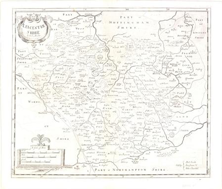
Leicester, England (Leicester Shire), Morden, Britannia, London, ca. 1722. 17 x 14”. (BW) This county map of Leicester shows the early road system. The town of Leicester is located near the center of the map along the Soar River. The map is divided into Hundreds and displays interesting detail including the locations of buildings, rivers, bridges and parks. There is a decorative title cartouche and three distance scales. Sold by Abel Swale, Awnsham & John Churchil. Morden was one of the first English cartographers to show longitudes measured from the meridian of St. Paul`s Cathedral (shown in degrees at the bottom of the map) and time in minutes measure locally from the sun (shown at the top in Roman numerals). The roads on his maps are based on Ogilby`s earlier survey. The Britannia was first published by historian William Camden (1551-1623) in 1586. After the publication of the final edition of Britannia in 1637, the work was not published again until 1695 when Gibson revised and translated the text from the original Latin and included fifty maps, mostly of the English counties, prepared by Robert Morden, replacing the outdated maps of Christopher Saxton. This map is from the subsequent edition of 1722. There is some light offsetting, else very good. Watermarked paper. (+B)

Northampton, England (Northampton Shire), Morden, Britannia, London, ca. 1722. 16 x 14”. (BW) This county map of Northamptonshire shows the early road system, with Northampton located at the center of the sheet. The map is divided into Hundreds and displays interesting detail including the locations of buildings, rivers, bridges and parks. There is an attractive drape-style cartouche and three distance scales. North is oriented to the right. Sold by Abel Swale, Awnsham & John Churchil. Morden was one of the first English cartographers to show longitudes measured from the meridian of St. Paul`s Cathedral (shown in degrees at the bottom of the map) and time in minutes measure locally from the sun (shown at the top in Roman numerals). The roads on his maps are based on Ogilby`s earlier survey. The Britannia was first published by historian William Camden (1551-1623) in 1586. After the publication of the final edition of Britannia in 1637, the work was not published again until 1695 when Gibson revised and translated the text from the original Latin and included fifty maps, mostly of the English counties, prepared by Robert Morden, replacing the outdated maps of Christopher Saxton. This map is from the subsequent edition of 1722. There is a hint of toning along the centerfold, with a portion of the centerfold reinforced with old paper. Watermarked paper. (+B)

Cheshire, England (The County Palatine of Chester), Morden, Britannia, London, ca. 1722. 16 x 14”. (BW) This county map of Cheshire shows the early road system with the town of Chester located on the left side of the sheet next to the River Dee. The map is divided into Hundreds and displays interesting detail including the locations of buildings, rivers, bridges and parks. There is a decorative title cartouche and three distance scales. Sold by Abel Swale, Awnsham & John Churchil. Morden was one of the first English cartographers to show longitudes measured from the meridian of St. Paul`s Cathedral (shown in degrees at the bottom of the map) and time in minutes measure locally from the sun (shown at the top in Roman numerals). The roads on his maps are based on Ogilby`s earlier survey. The Britannia was first published by historian William Camden (1551-1623) in 1586. After the publication of the final edition of Britannia in 1637, the work was not published again until 1695 when Gibson revised and translated the text from the original Latin and included fifty maps, mostly of the English counties, prepared by Robert Morden, replacing the outdated maps of Christopher Saxton. This map is from the subsequent edition of 1722. There is light toning along the centerfold, faint offsetting and a few tiny spots in the image. There is one minute pinhole at left and a printer`s crease along the lower neatline. Watermarked paper. (+B)

Wilts, England (Wilt Shire), Morden, Britannia, London, ca. 1722. 16.3 x 13.5”. (BW) This county map of Wiltshire shows the early road system. The map is divided into Hundreds and displays interesting detail including the locations of buildings, rivers, bridges parks and mountains in profile. There is an attractive drape-style cartouche and three distance scales. Sold by Abel Swale, Awnsham & John Churchil. Morden was one of the first English cartographers to show longitudes measured from the meridian of St. Paul`s Cathedral (shown in degrees at the bottom of the map) and time in minutes measure locally from the sun (shown at the top in Roman numerals). The roads on his maps are based on Ogilby`s earlier survey. The Britannia was first published by historian William Camden (1551-1623) in 1586. After the publication of the final edition of Britannia in 1637, the work was not published again until 1695 when Gibson revised and translated the text from the original Latin and included fifty maps, mostly of the English counties, prepared by Robert Morden, replacing the outdated maps of Christopher Saxton. This map is from the subsequent edition of 1722. Watermarked paper with some offsetting, light printer`s ink residue, and a 0.5" hole near the centerfold repaired with old paper on verso, with minor loss of image. (B)

Stafford, England (Stafford Shire), Morden, Britannia, London, ca. 1722. 14.5 x 17”. (BW) This county map of Staffordshire shows the early road system, with the town of Stafford located at the center of the sheet. The map displays interesting detail including the locations of buildings, rivers, bridges and parks. There is a decorative title cartouche and three distance scales. Engraved by Sutton Nicholls and sold by Abel Swale, Awnsham & John Churchil. Morden was one of the first English cartographers to show longitudes measured from the meridian of St. Paul`s Cathedral (shown in degrees at the bottom of the map) and time in minutes measure locally from the sun (shown at the top in Roman numerals). The roads on his maps are based on Ogilby`s earlier survey. The Britannia was first published by historian William Camden (1551-1623) in 1586. After the publication of the final edition of Britannia in 1637, the work was not published again until 1695 when Gibson revised and translated the text from the original Latin and included fifty maps, mostly of the English counties, prepared by Robert Morden, replacing the outdated maps of Christopher Saxton. This map is from the subsequent edition of 1722. There is some faint offsetting, a hint of toning along the fold, and a printer`s crease above the centerfold. Watermarked paper. (+B)

Lincoln, England (Lincoln Shire), Morden, Britannia, London, ca. 1722. 16.5 x 14.3”. (BW) This county map of Lincolnshire shows the early road system, with the town of Lincoln located near the center of the sheet. The map displays interesting detail including the locations of buildings, rivers, bridges and parks. There is a decorative title cartouche and three distance scales. Sold by Abel Swale, Awnsham & John Churchil. Morden was one of the first English cartographers to show longitudes measured from the meridian of St. Paul`s Cathedral (shown in degrees at the bottom of the map) and time in minutes measure locally from the sun (shown at the top in Roman numerals). The roads on his maps are based on Ogilby`s earlier survey. The Britannia was first published by historian William Camden (1551-1623) in 1586. After the publication of the final edition of Britannia in 1637, the work was not published again until 1695 when Gibson revised and translated the text from the original Latin and included fifty maps, mostly of the English counties, prepared by Robert Morden, replacing the outdated maps of Christopher Saxton. This map is from the subsequent edition of 1722. There are a few minor spots in the image and a small printer`s crease in the upper portion of the image near the neatline. Watermarked paper. (+B)

Berkshire, England (Bark Shire), Morden, Britannia, London, ca. 1722. 16.5 x 14”. (BW) This county map of Berkshire shows the early road system and Windsor Castle at lower right. The map is divided into Hundreds and displays interesting detail including the locations of buildings, rivers, bridges and parks. There is an attractive drape-style cartouche and three distance scales. Sold by Abel Swale, Awnsham & John Churchil. Morden was one of the first English cartographers to show longitudes measured from the meridian of St. Paul`s Cathedral (shown in degrees at the bottom of the map) and time in minutes measure locally from the sun (shown at the top in Roman numerals). The roads on his maps are based on Ogilby`s earlier survey. The Britannia was first published by historian William Camden (1551-1623) in 1586. After the publication of the final edition of Britannia in 1637, the work was not published again until 1695 when Gibson revised and translated the text from the original Latin and included fifty maps, mostly of the English counties, prepared by Robert Morden, replacing the outdated maps of Christopher Saxton. This map is from the subsequent edition of 1722. There is some light offsetting and printer`s ink residue in the image, else very good. A tiny tear in bottom blank margin has been closed on verso with old paper. Watermarked paper. (+B)

Nottingham, England (Nottingham Shire), Morden, Britannia, London, ca. 1722. 16 x 14”. (BW) This county map of Nottinghamshire shows the early road system, with the town of Nottingham located in the lower portion of the sheet. The map displays interesting detail including the locations of buildings, rivers, bridges and parks. There is a decorative title cartouche and three distance scales. Sold by Abel Swale, Awnsham & John Churchil. Morden was one of the first English cartographers to show longitudes measured from the meridian of St. Paul`s Cathedral (shown in degrees at the bottom of the map) and time in minutes measure locally from the sun (shown at the top in Roman numerals). The roads on his maps are based on Ogilby`s earlier survey. The Britannia was first published by historian William Camden (1551-1623) in 1586. After the publication of the final edition of Britannia in 1637, the work was not published again until 1695 when Gibson revised and translated the text from the original Latin and included fifty maps, mostly of the English counties, prepared by Robert Morden, replacing the outdated maps of Christopher Saxton. This map is from the subsequent edition of 1722. Watermarked paper with some light offsetting and a few small spots in the image, else very good. (+B)

England & Wales (England), Morden, Camden`s Britannia, London, ca. 1695. 16.5 x 14.3”. (HC) Robert Morden was commissioned by Dr. Edmund Gibson to prepare new maps for Camden`s Britannia, which was last published early in the century with maps by Hole and Kip. However, no additional survey work was done by Morden, so this map draws largely upon the work of Saxton and Speed. The map itself is relatively straightforward and depicts counties, cities and roads. The title is enclosed in an elegant cartouche along with three distance scales. Ref: Shirley (BI to 1750) Morden 10. There is a 0.25" loss near Gloucester that has been covered with old paper on verso and light toning in blank margins. (+B)
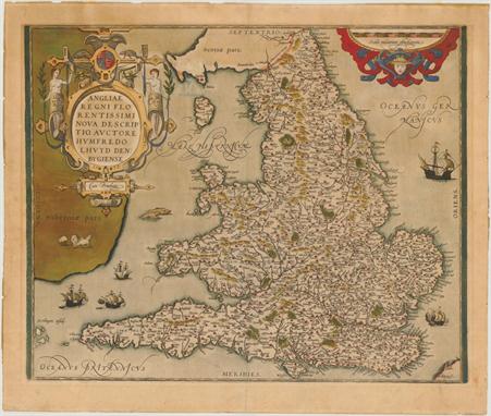
England & Wales (Angliae Regni Florentissimi Nova Descriptio, Auctore Humfredo Lhuyd Denbygiense), Ortelius, Theatrum Orbis Terrarum, Antwerp, 1573. 18.3 x 15”. (HC) Stunning map of England and Wales compiled from Mercator`s 1564 wall map of the British Isles and Lhuyd`s manuscript map of 1568. The countryside is fully engraved with topographical features and hundreds of towns. This map improved on Mercator`s outline of the countries particularly in Cardigan and South Wales, the Devon peninsula, and the Wash and Humber inlets. Interestingly the Caernarvon peninsula, near Lhuyd`s hometown of Denbigh, is badly distorted and it has been suggested that this may be due to his sketching it from one of the nearby mountains. Sea monsters and five sailing ships occupy the stipple engraved oceans. A flock of sheep is shown in Ireland and there are two large, elaborate cartouches. Dated 1573 in the cartouche and published in the Latin edition of 1592. Ref: Van den Broecke no.19.2; Shirley (BI) no.100. Old color on watermarked paper with some light color bleed through from verso just to the right of the title cartouche. There is light toning and remnants of hinge tape on verso. (+B)

England & Wales (Anglia Regnum), Jansson, Amsterdam, ca. 1638. 19.5 x 15.3”. (HC) This fine map of England and Wales was copied from Willem Blaeu`s map and its decorations are nearly identical except that Jansson has added heraldic shields in Scotland and Ireland. It is decorated with four ships, a scale of miles flanked by sheep and a cherub, and two finely engraved coats of arms, of Great Britain and of England, surmounting the title cartouche. Latin text on the verso. Ref: Shirley (BI) no.465. There is a small hole in the image near Hereford and remnants of paper tape on verso along the top edge. (+B)
-
109198 item(s)/page