We found 109198 price guide item(s) matching your search
There are 109198 lots that match your search criteria. Subscribe now to get instant access to the full price guide service.
Click here to subscribe- List
- Grid
-
109198 item(s)/page


Lot 151
Amerika. Nordamerika – die großen Seen. Grenzkolorierte Kupferstichkarte von Conrad Lotter um 1760. Die linke obere Hälfte einer größeren Karte. Bildgröße 56,5 x 48 cm (Querformat). (71)* Die Karte zeigt das Gebiet der großen Seen mit Teilen von Michigan, Wisconsin, Iowa, Illinois und Ohio. Links oben eine separate Karte mit Detailvergrößerung “Particular Map of Baffin and Hudsons Bay. Bildgröße 25 x 22,5 cm. Zustand: Papierbedingt gebräunt und fleckig. In der Mitte mit Knickfalte, die Ränder sind beschnitten, stärker gebräunt und fleckig. Rückseitig mit Klebe- und Montageresten.


Lot 154
Vinyl - 5 UK pressings album by Man to include: Revelation (original UK Pye Records, NSPL 18275), 2 Ozs. Of Plastic With A Hole In The Middle (original UK transparent dark red vinyl, gatefold, lilac labels, Dawn Records DNLS 3003), Man (original UK 1st pressing, textured gatefold sleeve, Liberty Records LBG 83464), Be Good To Yourself At Least Once A Day (original UK 1st pressing, 'map’ gatefold sleeve with 'family tree' inner sleeve, United Artists UAG 29417), Rhinos, Winos And Lunatics (original UK 1st pressing gatefold sleeve, United Artists tag 29631). Condition VG to VG+ overall


Lot 1251
MERIAN, Matthäus d. Ä.(1593 Basel - 1650 Schwalbach) Plan der Stadt ErfurtKupferstich.Druckplatte: 29 x 38,5 cm, Blatt: 33,3 x 41,6 cm, im Passepartout: 35,2 x 50 cm. Historische Gesamtansicht aus der Vogelperspektive der thüringischen Stadt Erfurt mit Stadtmauer, mit Titelkartusche und Legende Hinterklebte Bugfalte, etwas stockfleckig und griffspurig.Schweizerisch-deutscher Verleger und Kupferstecher. Sein Hauptwerk ist die Topographia Germaniae. MERIAN, Matthäus the Elder(1593 Basel - 1650 Schwalbach) Map of the city of ErfurtCopper engraving.Printing plate: 29 x 38.5 cm, sheet: 33.3 x 41.6 cm, in passepartout: 35.2 x 50 cm.Historical general view from the bird's eye view of the Thuringian city of Erfurt with city walls, with title cartouche and legend Backglued centerfold, some foxing and grip.Swiss-German publisher and engraver. His main work is the Topographia Germaniae.*This is an automatically generated translation from German by deepl.com and only to be seen as an aid - not a legally binding declaration of lot properties. Please note that we can only guarantee for the correctness of description and condition as provided by the German description.

Lot 1257
MERCATOR, Gerhard(1512 Rupelmonde - 1594 Duisburg) 2 Landkarten: Griechenland | Peloponnes2 Kupferstiche auf Bütten. Je im Passepartout: max. 50 x 60 cm. Historische Landkarten der griechischen Region Peloponnes, Titelkartusche "Morea Olim Peloponnes", verso typografischer Text in lateinischer Sprache, Druckplatte: 33,5 x 41 cm, Blatt: 45 x 55 cm, Bugfalte, Blatt griffspurig, Randbereich mit kleiner Hinterklebung | Historische Landkarte des nördlichen Griechenland, Titelkartusche "Macedonia, Epirus et Achaia", verso typografischer Text in lateinischer Sprache, Druckplatte: 35,5 x 43 cm, Blatt: 46 x 56 cm, hinterklebte Bugfalte, Blatt griffspurig; aus dem berühmten Mercator-Hondius Atlas, ab 1606 Flämischer Karten- und Globenhersteller, Kosmograf, Theologe und Philosoph. Sein Meisterwerk ist die Weltkarte von 1569, die erstmals die Darstellung der Erde in einer winkeltreuen Projektion zeigte. MERCATOR, Gerhard(1512 Rupelmonde - 1594 Duisburg) 2 maps: Greece | Peloponnese2 copperplate engravings on laid paper. Each in a mount: max 50 x 60 cm. Historical maps of the Greek region of Peloponnese, title cartouche "Morea Olim Peloponnese", typographic text in Latin on verso, printing plate: 33.5 x 41 cm, sheet: 45 x 55 cm, centerfold, sheet grip-marked, marginal area with small back-taped | Historical map of northern Greece, title cartouche "Macedonia, Epirus et Achaia", verso typographic text in Latin, printing plate: 35.5 x 43 cm, sheet: 46 x 56 cm, back-taped centerfold, sheet grip-marked; from the famous Mercator-Hondius Atlas, from 1606 Flemish map and globe maker, cosmographer, theologian and philosopher. His masterpiece is the world map of 1569, which showed for the first time the representation of the Earth in a projection true to the angle. *This is an automatically generated translation from German by deepl.com and only to be seen as an aid - not a legally binding declaration of lot properties. Please note that we can only guarantee for the correctness of description and condition as provided by the German description.

Lot 1258
ORTELIUS, Abraham(1527 Antwerpen - 1598 Antwerpen) Landkarte von RumänienKupferstich auf Bütten.Druckplatte: 37 x 50,6 cm, Blatt: 46,5 x 60,2 cm. Dekorative historische Landkarte von Rumänien und angrenzender Regionen, mit großer Rollwerk-Titelkartusche "Romaniae (quae olim Thracia dicta) Vicinorumque Regionum, uti Bulgariae [...]", verso typografischer Text in lateinischer Sprache; aus "Theatrum Orbis Terrarum", 1584 Bugfalte, griffspurig, größerer Wasserfleck am oberen Rand.Flämischer Geograf und Kartograf. Sein Hauptwerk ist das "Theatrum Orbis Terrarum", der erste kommerziell erfolgreiche Atlas, der in 42 Auflagen zwischen 1570 und 1612 herausgegeben wurde. Die Vermutung zum Zusammenhang der Kontinente in seinem Werk "Thesaurus Geographicus" gilt als erster schriftlicher Beleg für die Grundlagen der Theorien zur Kontinentalverschiebung. ORTELIUS, Abraham(1527 Antwerp - 1598 Antwerp) Map of RomaniaCopper engraving on laid paper.Print plate: 37 x 50.6 cm, sheet: 46.5 x 60.2 cm.Decorative historical map of Romania and adjacent regions, with large scrollwork title cartouche "Romaniae (quae olim Thracia dicta) Vicinorumque Regionum, uti Bulgariae [...]", typographical text in Latin on verso; from "Theatrum Orbis Terrarum", 1584 Buck crease, traces of handling, larger water stain on upper margin.Flemish geographer and cartographer. His main work is the "Theatrum Orbis Terrarum", the first commercially successful atlas, published in 42 editions between 1570 and 1612. The conjecture on the connection of the continents in his work "Thesaurus Geographicus" is considered the first written evidence of the foundations of the theories of continental drift.*This is an automatically generated translation from German by deepl.com and only to be seen as an aid - not a legally binding declaration of lot properties. Please note that we can only guarantee for the correctness of description and condition as provided by the German description.
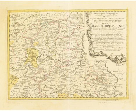
Lot 1260
HOMANN, Johann Baptist (Erben) Landkarte der Landgrafschaft Hessen-DarmstadtKolorierter Kupferstich. In der Platte datiert: [17]54.Blatt: 54 x 62 cm. Detailreiche historische Karte der Landgrafschaft Hessen-Darmstadt, Titelkartusche mit Jagdszene und ausführlicher Legende "Delineatio Geographica generalis comprehendens VI. Folis [...] Landgrafii Hasso-Darmstadiensis [...], gezeichnet von Christoph Pronner Bugfalte, etwas stockfleckig, lichtgebräunt und verschmutzt.Johann Baptist Homann (1664 - 1724), deutscher Kartograf, Kupferstecher, Verleger und Globenhersteller; bedeutendster deutscher Herausgeber von Atlanten und Landkarten im 18. Jh. HOMANN, Johann Baptist (Heirs) Map of the Landgraviate of Hesse-DarmstadtColored copperplate engraving. Dated in the plate: [17]54.Sheet: 54 x 62 cm.Detailed historical map of the Landgraviate of Hesse-Darmstadt, title cartouche with hunting scene and detailed legend "Delineatio Geographica generalis comprehendens VI. Folis [...] Landgrafii Hasso-Darmstadiensis [...], drawn by Christoph Pronner Buck crease, some foxing, light browned and soiled.Johann Baptist Homann (1664 - 1724), German cartographer, engraver, publisher and globe maker; most important German publisher of atlases and maps in the 18th century.*This is an automatically generated translation from German by deepl.com and only to be seen as an aid - not a legally binding declaration of lot properties. Please note that we can only guarantee for the correctness of description and condition as provided by the German description.
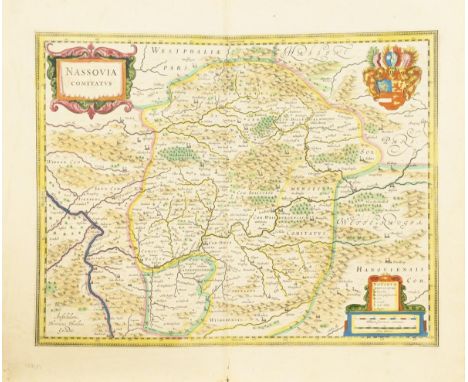
Lot 1264
HONDIUS, Henricus(1597 Amsterdam - 1651 Amsterdam) Landkarte des Herzogtums NassauKolorierter Kupferstich. Ca. 1650. Blatt: 49,4 x 57,5 cm. Detailreiche historische Karte des Herzogtums Nassau, Titelkartusche "Nassovia Comitatus", Beikartusche mit Legende und Meilenzeigern sowie Wappendarstellung, verso typografischer Text in französischer Sprache Bugfalte, Randbereich lichtgebräunt, griff- und knickspurig. Niederländischer Kupferstecher und Verleger; er gab ab 1641 den Mercator-Hondius-Atlas in neuer Auflage mit veränderten Karten heraus. HONDIUS, Henricus(1597 Amsterdam - 1651 Amsterdam) Map of the Duchy of NassauColor copperplate engraving. Ca. 1650. Sheet: 49.4 x 57.5 cm. Detailed historical map of the Duchy of Nassau, title cartouche "Nassovia Comitatus", subsidiary cartouche with legend and mileage pointers and heraldry, typographical text in French on verso Buckling, marginal area light browned, traces of handling and creases. Dutch engraver and publisher; he published the Mercator Hondius Atlas in new editions with modified maps from 1641. *This is an automatically generated translation from German by deepl.com and only to be seen as an aid - not a legally binding declaration of lot properties. Please note that we can only guarantee for the correctness of description and condition as provided by the German description.

Lot 1266
LOTTER, Tobias Conrad(1717 - 1777 Augsburg) Karte der Stadt BerlinKolorierter Kupferstich. Gerahmt & hinter Glas56,5 x 64,5 cm. Historischer Stadtplan von Berlin, mit panoramaartiger Gesamtansicht der Stadt, großer figürlicher Titelkartusche mit ausführlicher Legende in deutscher Sprache, bezeichnet "Berlin die Praechtigste und maechtigste Hauptstatt des Churfürstenthums Brandenburg, auch Residenz des Königes in Preußen und florissanter Handels-Plaz, verfertiget und verlegt von Tobias Conrad Lotter" Gerissene Bugfalte, Randbereich griff- und knickspurig, Randbereich rissig, etwas stockfleckig. Deutscher Kupferstecher und Kartograf. Nach dem Tod seines Schwiegervaters Matthäus Seutter (1678 - 1757) führt er dessen Verlag weiter. LOTTER, Tobias Conrad(1717 - 1777 Augsburg) Map of the city of BerlinColored copperplate engraving. Framed & behind glass56.5 x 64.5 cm. Historical map of Berlin, with panoramic general view of the city, large figural title cartouche with detailed legend in German, denoting "Berlin die Praechtigste und maechtigste Hauptstatt des Churfürstenthums Brandenburg, auch Residenz des Königs in Preußen und florissanter Handels-Plaz, verfertiget und verlegt von Tobias Conrad Lotter" Torn centerfold, marginal grip and crease, marginal tear, some foxing. German engraver and cartographer. After the death of his father-in-law Matthäus Seutter (1678 - 1757) he continues his publishing house. *This is an automatically generated translation from German by deepl.com and only to be seen as an aid - not a legally binding declaration of lot properties. Please note that we can only guarantee for the correctness of description and condition as provided by the German description.
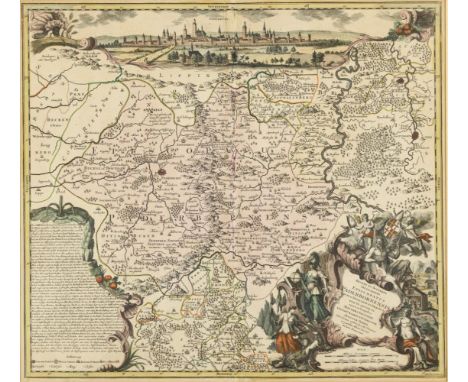
Lot 1267
LOTTER, Tobias Conrad(1717 - 1777 Augsburg) Karte des Hochstifts PaderbornKolorierter Kupferstich. Nach 1741. Gerahmt & hinter Glas66 x 71 cm. Historische Karte des Hochstifts Paderborn, mit panoramaartiger Gesamtansicht von Paderborn, großer figürlicher Titelkartusche und großer Textkartusche in deutscher Sprache bezeichnet "Recens Et Accurata Designatio Episcopatus Paderbornensis In Suas Et Praefect Exacte Distincti opera et sumptibus Matthaei Seutteri, Geogr. Caesarei Et Chalcogr. Augustae Vindel [...]", verlegt bei Matthäus Seutter in Augsburg Bugfalte, Blattrand lichtgebräunt, griffspurig. Deutscher Kupferstecher und Kartograf. Nach dem Tod seines Schwiegervaters Matthäus Seutter (1678 - 1757) führte er dessen Verlag weiter. LOTTER, Tobias Conrad(1717 - 1777 Augsburg) Map of the High Collegiate PaderbornColored copperplate engraving. After 1741. Framed & behind glass66 x 71 cm. Historical map of the High Diocese of Paderborn, with panoramic general view of Paderborn, large figural title cartouche and large text cartouche inscribed in German "Recens Et Accurata Designatio Episcopatus Paderbornensis In Suas Et Praefect Exacte Distincti opera et sumptibus Matthaei Seutteri, Geogr. Caesarei Et Chalcogr. Augustae Vindel [...]", published by Matthäus Seutter in Augsburg Buckling, leaf margin light browned, traces of handling. German engraver and cartographer. After the death of his father-in-law Matthäus Seutter (1678 - 1757), he continued his publishing house. *This is an automatically generated translation from German by deepl.com and only to be seen as an aid - not a legally binding declaration of lot properties. Please note that we can only guarantee for the correctness of description and condition as provided by the German description.
![THOMSON, John(1777 - 1840) Landkarte des Europäischen RusslandsKolorierter Kupferstich. In der Platte datiert: [18]15.Blat](https://cdn.globalauctionplatform.com/8dc16d45-a509-4960-8b91-b00300f89be9/1a07b7ec-10c0-4754-85ff-b019017e2db4/468x382.jpg)
Lot 1271
THOMSON, John(1777 - 1840) Landkarte des Europäischen RusslandsKolorierter Kupferstich. In der Platte datiert: [18]15.Blatt: 72 x 54 cm. Detailreiche historische Karte des Europäischen Russlands "European Russia", aus "New General Atlas", 1817 Bugfalte, stockfleckig.Schottischer Kartograf. THOMSON, John(1777 - 1840) Map of European RussiaColored copperplate engraving. Dated in the plate: [18]15.Sheet: 72 x 54 cm.Detailed historical map of European Russia "European Russia", from "New General Atlas", 1817 Buck crease, foxing.Scottish cartographer.*This is an automatically generated translation from German by deepl.com and only to be seen as an aid - not a legally binding declaration of lot properties. Please note that we can only guarantee for the correctness of description and condition as provided by the German description.
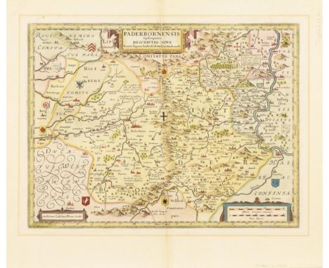
Lot 1275
GIGAS, Johannes(1582 Lüdge - 1637 Münster) Karte des Hochstifts PaderbornKolorierter Kupferstich. Ca. 1620 - 1635.Druckplatte: 38 x 50 cm, Blatt: 51,3 x 58,7 cm. Fein kolorierte historische Karte des Hochstifts Paderborn, mit Rollwerk-Titelkartusche "Paderbornensis Episcopatius Descriptio Nova [...]" und Kartusche mit Maßstab, verso mit Begleittext in spanischer Sprache; verlegt bei Guiljelmus Blaeuw (=Willem Janszoon Blaeu) in Amsterdam Bugfalte, Abbildung lichtgebräunt, griffspurig, oben rechts mit Hinterklebung.Deutscher Kartograf, Mediziner, Mathematiker und Physiker. GIGAS, Johannes(1582 Lüdge - 1637 Münster) Map of the High Collegiate PaderbornColored copperplate engraving. Ca. 1620 - 1635.Printing plate: 38 x 50 cm, sheet: 51.3 x 58.7 cm.Fine colored historical map of the High Diocese of Paderborn, with scrollwork title cartouche "Paderbornensis Episcopatius Descriptio Nova [...]" and cartouche with scale, verso with accompanying text in Spanish; published by Guiljelmus Blaeuw (=Willem Janszoon Blaeu) in Amsterdam Buck crease, illustration light browned, traces of handling, upper right backstamp.German cartographer, physician, mathematician and physicist.*This is an automatically generated translation from German by deepl.com and only to be seen as an aid - not a legally binding declaration of lot properties. Please note that we can only guarantee for the correctness of description and condition as provided by the German description.
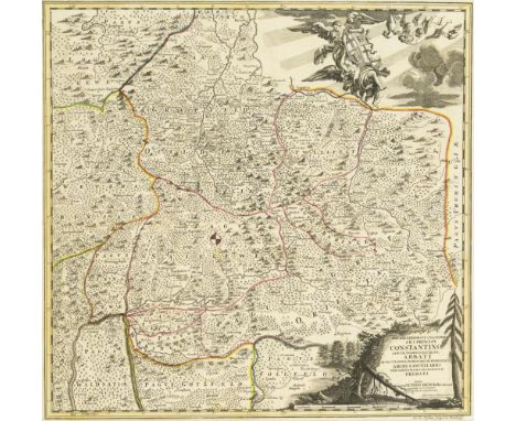
Lot 1276
PUSCHNER, Johann Georg(1680 - 1749) Landkarte des Hochstifts FuldaKolorierter Kupferstich.Druckplatte: 50 x 51,5 cm. Gerahmt & hinter Glas67 x 75,5 cm. Historische detailreiche Landkarte der Fürstabtei Fulda, mit Titelkartusche mit Widmung an Abt Konstantin von Fulda "Reverendissimo Et Celsissimo S. R. I. Principi Constantino Sanctae Fuldensis Ecclesiae Abbati [...]" und großer Figurenkartusche mit Wappen, nach einer Karte von Johann Friedrich Schannat (1683 -1739) Bugfalten, etwas griffspurig.Deutscher Astronom und Kupferstecher. PUSCHNER, Johann Georg(1680 - 1749) Map of the High Collegiate FuldaColored copperplate.Printing plate: 50 x 51.5 cm. Framed & behind glass67 x 75.5 cm.Historical detailed map of the Princely Abbey of Fulda, with title cartouche with dedication to Abbot Constantine of Fulda "Reverendissimo Et Celsissimo S. R. I. Principi Constantino Sanctae Fuldensis Ecclesiae Abbati [...]" and large figural cartouche with coat of arms, after a map by Johann Friedrich Schannat (1683 -1739) Buck creases, some grip.German astronomer and engraver.*This is an automatically generated translation from German by deepl.com and only to be seen as an aid - not a legally binding declaration of lot properties. Please note that we can only guarantee for the correctness of description and condition as provided by the German description.

Lot 1279
6 historische LandkartenJe im Passepartout: 35 x 50. Historische Landkarte der Insel Rügen, Titelkartusche mit Wappen "Rugia Insula Ac Ducatus", Druckplatte: 20 x 25,6 cm; aus "Theatrum Orbis Terrarum" von Abraham Ortelius, Bugfalte, etwas stockfleckig | Historische Landkarte der niederländischen Provinz Zeeland, figürliche Titelkartusche "Zelande", Meilenzeiger, Druckplatte: 21 x 28 cm, von George Louis Le Rouge, Bugfalte, etwas stockfleckig | Historische Landkarte der Philippinischen Inseln "Carte des Nouvelles Philippines / Kaart der Nieuwe Philippynsche Eylanden", Druckplatte: 21 x 21 cm, von Jacques-Nicolas Bellin, ca. 1757, Bugfalten, etwas fleckig und griffspurig | Historische Belagerungskarte der Stadt Hertogenbosch, Titelkartusche "Beleegeringe vande Stadt Hertogenbosch Anno 1629", Druckplatte: 27,5 x 36 cm, von Frederik Hendrik, etwas stockfleckig, Bugfalte | Historische Landkarte der indonesischen Insel Sulawesi "Carte de Isle Celebes ou Macassar / Kaart van't Eiland Celebes of Makassar", Meilenzeiger Druckplatte: 23 x 15 cm, von Jacques-Nicolas Bellin, etwas griffspurig | Historische Landkarte der des Erdteils "Europa", Druckplatte: 21,5 x 27 cm; aus "Stielers's Schul-Atlas No. III", von Justus Perthes, etwas stockfleckig 6 historical mapsEach in a mount: 35 x 50. Historical map of the island of Rügen, title cartouche with coat of arms "Rugia Insula Ac Ducatus", printing plate: 20 x 25,6 cm; from "Theatrum Orbis Terrarum" by Abraham Ortelius, centerfold, some foxing | Historical map of the Dutch province of Zeeland, figural title cartouche "Zelande", mileage indicator, printing plate: 21 x 28 cm, by George Louis Le Rouge, centerfold, some foxing | Historical map of the Philippine Islands "Carte des Nouvelles Philippines / Kaart der Nieuwe Philippynsche Eylanden", printing plate: 21 x 21 cm, by Jacques-Nicolas Bellin, ca. 1757, centerfolds, some staining and handling | Historical siege map of the city of Hertogenbosch, title cartouche "Beleegeringe vande Stadt Hertogenbosch Anno 1629", printing plate: 27.5 x 36 cm, by Frederik Hendrik, some foxing, centerfold | Historical map of the Indonesian island of Sulawesi "Carte de Isle Celebes ou Macassar / Kaart van't Eiland Celebes of Makassar", mileage indicator printing plate: 23 x 15 cm, by Jacques-Nicolas Bellin, some handling marks | Historical map of the continent "Europe", printing plate: 21.5 x 27 cm; from "Stielers's Schul-Atlas No. III", by Justus Perthes, some foxing *This is an automatically generated translation from German by deepl.com and only to be seen as an aid - not a legally binding declaration of lot properties. Please note that we can only guarantee for the correctness of description and condition as provided by the German description.
Lot 1280
3 Ansichten der Stadt Halberstadt Karte von Halberstadt und Umgebung als Schauplatz und militärisches Lager während des Siebenjährigen Krieges in Westfalen und Niedersachsen, bezeichnet "Camp d'Halberstat, commandé par Mr. le M.al de Richelieu du 28 7.bre au 5 Novembre 1757", aquarellierter Kupferstich von Jacob van der Schley, Blatt 52 von 56, in "Camps topographiques de la campagne de MDCCLVII (1757), 1760, Platte: 12,3 x 18,5 cm, gerahmt & hinter Glas: 25,5 x 31,5 cm, Rand lichtgebräunt, etwas griffspurig | Historische Ansicht der Stadt "Halberstatt" aus "Commentariorium Rerum Germanicum libri tres" von Petrus Bertius, 1616, kolorierter Kupferstich, Platte: 14 x 19 cm, gerahmt & hinter Glas: 29,7 x 34,5 cm, durchscheinender typografischer Text von verso, minimal stockfleckig | Historische Landkarte des Fürstentums Halberstadt "Nro. 325" von Franz Johann Joseph von Reilly, kolorierter Kupferstich, Platte: 24,5 x 29,5 cm, gerahmt & hinter Glas: 45,5 x 50,5 cm, um 1790, Blatt lichtgebräunt 3 views of the city of Halberstadt Map of Halberstadt and surroundings as a theater and military camp during the Seven Years' War in Westphalia and Lower Saxony, inscribed "Camp d'Halberstat, commandé par Mr. le M.al de Richelieu du 28 7.bre au 5 Novembre 1757", watercolor engraving by Jacob van der Schley, sheet 52 of 56, in "Camps topographiques de la campagne de MDCCLVII (1757), 1760, plate: 12.3 x 18.5 cm, framed & behind glass: 25.5 x 31.5 cm, margins light browned, some handling marks | Historical view of the town of "Halberstatt" from "Commentariorium Rerum Germanicum libri tres" by Petrus Bertius, 1616, colored copper engraving, plate: 14 x 19 cm, framed & behind glass: 29.7 x 34.5 cm, translucent typographic text from verso, minimal foxing | Historical map of the Principality of Halberstadt "Nro. 325" by Franz Johann Joseph von Reilly, colored copperplate engraving, plate: 24.5 x 29.5 cm, framed & behind glass: 45.5 x 50.5 cm, circa 1790, sheet light browned *This is an automatically generated translation from German by deepl.com and only to be seen as an aid - not a legally binding declaration of lot properties. Please note that we can only guarantee for the correctness of description and condition as provided by the German description.

Lot 1281
ALBERTI, I Historische Karte des nördlichen SternenhimmelsKupferstich. Im Druck datiert: 1787. Gerahmt & hinter Glas73,5 x 69 cm. Darstellung des nördlichen Sternenhimmels mit Sternbildern, bezeichnet "Stereographischer Entwurf des gestirnten Himmels vom Nordpol bis zum 38sten Grad südlicher Abweichung von Herrn I. Bode. Neu herausgegeben von Herrn F. Schraembl" Bugfalte, kleine Löcher und Risse, Wasserflecken, griffspurig. ALBERTI, I Historical Map of the Northern Starry SkyCopper engraving. Dated in print: 1787. Framed & behind glass73.5 x 69 cm. Depiction of the northern starry sky with constellations, inscribed "Stereographischer Entwurf des gestirnten Himmels vom Nordpol bis zum 38sten Grad südlicher Abweichung von Herrn I. Bode. Newly published by Mr. F. Schraembl" Buck crease, small holes and tears, water stains, traces of grip. *This is an automatically generated translation from German by deepl.com and only to be seen as an aid - not a legally binding declaration of lot properties. Please note that we can only guarantee for the correctness of description and condition as provided by the German description.

Lot 2739
LandkartenverkäuferMeissen. 1910. Modell-Nr. 868 (neue Form-Nr. 73099). Höhe: 16,5 cm. Modell von Peter Reinicke 1744. Farbig bemalt. Ritzmarke, Pressmarke, Malermarke, Schwertermarke, Jubiläumsmarke Karte partiell sichtbar alt restauriert. Reinicke, Bildhauer, seit 1743 Modelleur in Meissen, schuf zahlreiche Figuren, Mitarbeiter von Johann Joachim Kaendler. Meissen-Manufaktur-Preis: 4800,- Euro * Partnerauktion Bergmann. Literatur : Bergmann (2017) Katalog-Nr. 1322. Provenienz : Hessische Privatsammlung. Map sellerMeissen. 1910. model no. 868 (new mold no. 73099). Height: 16.5 cm. Model by Peter Reinicke 1744. colorfully painted. Incised mark, press mark, painter's mark, sword mark, jubilee mark Card partially restored visible old. Reinicke, sculptor, since 1743 modeller in Meissen, created numerous figures, collaborator of Johann Joachim Kaendler. Meissen manufactory price: 4800, - Euro * Partner auction Bergmann. Literature : Bergmann (2017) catalog no. 1322. Provenance : Hessian private collection. *This is an automatically generated translation from German by deepl.com and only to be seen as an aid - not a legally binding declaration of lot properties. Please note that we can only guarantee for the correctness of description and condition as provided by the German description.
Lot 3311
Stuttgarter Bibel von 1704Verlegts Augustus Metzler, Buchhändler. Stuttgart. 22 x 13 x 11 cm. Titelkupfer, Titel, handschriftliche Seite, (54) Seiten mit drei Porträtkupferstichen von Adligen, 640, Kupferstich, (16), 280, 210, Kupferstich, (16), 356 und sehr umfangreiches Register von mehreren hundert unnummerierten Seiten. Weiterhin Holzschnittvignetten und einige kleinere Kupferstiche, sowie lose Landkarte (defekt in zwei Teilen). Ledereinband Schließen und Vorsatz fehlt, starke Nutzungsspuren aber fester Block, Ledereinband alt repariert. Stuttgart Bible of 1704Verlegts Augustus Metzler, Buchhändler. Stuttgart. 22 x 13 x 11 cm. Title copperplate, title, handwritten page, (54) pages with three portrait copperplate engravings of noblemen, 640, copperplate, (16), 280, 210, copperplate, (16), 356 and very extensive index of several hundred unnumbered pages. Furthermore woodcut vignettes and some smaller copperplate engravings, and loose map (defective in two parts). Leather binding Closing and endpapers missing, heavy traces of use but solid block, leather binding old repaired. *This is an automatically generated translation from German by deepl.com and only to be seen as an aid - not a legally binding declaration of lot properties. Please note that we can only guarantee for the correctness of description and condition as provided by the German description.
Lot 3313
Sächsische Kurfürstenbibel In Verlegung Johann Andrä Endters seel. Erben. Nürnberg. 1736. 46 x 30 x 17 cm. Ausgabe durch Fürst Ernst, Herzog von Sachsen, ... und Fürst Friedrich III, Herzog zu Sachsen-Gotha veranlasst. Vorsatz mit zahlreichen Familieneinträgen. Vorrede von Ernst Salomon Cyprian. Titelkupfer, Titel, (36), 11 Churfürstenbilder und Lutherbildnis, (88), 3 ganzseitige Kupferstiche und Landkarte (an falscher Stelle gebunden), 740, 512, 480, (16) Seiten mit weiteren zahlreichen ganzseitigen Kupferstichen und Tafeln. Im schön geprägten Pergamenteinband mit Lutherbildnis und Schließen. Guter und schöner Erhaltungszustand. Sächsische Kurfürstenbibel In Verlegung Johann Andrä Endters seel. Heirs. Nuremberg. 1736. 46 x 30 x 17 cm.Edition by Prince Ernst, Duke of Saxony, ... and Prince Frederick III, Duke of Saxe-Gotha initiated. Endpapers with numerous family entries. Preface by Ernst Salomon Cyprian. Title copperplate, title, (36), 11 Churfürstenbilder and Luther portrait, (88), 3 full-page copperplate engravings and map (bound in wrong place), 740, 512, 480, (16) pages with additional numerous full-page copperplate engravings and plates. In beautiful embossed vellum binding with portrait of Luther and clasps. Good and beautiful state of preservation.*This is an automatically generated translation from German by deepl.com and only to be seen as an aid - not a legally binding declaration of lot properties. Please note that we can only guarantee for the correctness of description and condition as provided by the German description.
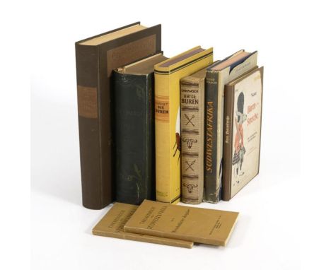
Lot 3331
8x Kolonialliteratur Deutsch Südwestafrika von Dicklagen-Campe: "Deutsche Reiter in Südwest", 480 Seiten. / Scheibert: "Der Freiheitskampf der Buren", 3 Teile in einem Band. 272, 400, 472 Seiten und 2 Karten. / Voigt: "Die Buren - südafrikanisches Grenzerbuch", 253 Seiten. / Jannasch: "Unter Buren, Briten, Bantus", 248 Seiten und Karte. / Hintrager: "Südwestafrika in der deutschen Zeit", 261 Seiten. / "Neue Buren-Streiche - Der Transvaalkrieg in der Karikatur", Berlin 1900, 86 Seiten, nachgebunden. / 2x "Taschenbuch für Südwestafrika" (Gesetze und Verordnungen; Wirtschaftlicher Ratgeber), Broschur 212 und 131 Seiten 8x Colonial Literature German Southwest Africa von Dicklagen-Campe: "German Riders in Southwest", 480 pp. / Scheibert: "The freedom struggle of the Boers", 3 parts in one volume. 272, 400, 472 pages and 2 maps. / Voigt: "The Boers - South African frontier book", 253 pages. / Jannasch: "Among Boers, British, Bantus", 248 pages and map. / Hintrager: "South West Africa in the German period", 261 pp. / "New Boer Pranks - The Transvaal War in Caricature", Berlin 1900, 86 pages, rebound. / 2x "Pocketbook for Southwest Africa" (laws and regulations; economic guide), softcover 212 and 131 pages .*This is an automatically generated translation from German by deepl.com and only to be seen as an aid - not a legally binding declaration of lot properties. Please note that we can only guarantee for the correctness of description and condition as provided by the German description.

Lot 3512
GRITCHENKO, Alexis zugeschrieben(1883 Krolewez - 1977 Vence) Rosenbukett mit KarteÖl auf Platte. Signiert. 32,5 x 49,5 cm. Gerahmt48 x 65 cm. Schwerer vergoldeter Stuckrahmen Rahmen partiell leicht defekt. Gritchenko, Kunsthistoriker, Maler, Aquarellist. Studierte an der Akademie in Moskau, bereiste Europa. Ab 1919 in Istanbul und seit 1921 in Paris tätig. Im Pariser Salon d'Automne vertreten. Nach 1924 in Südfrankreich ansässig. Werke in internationalen Museen * Partnerauktion Bergmann. Literatur : Saur (1992-2009), Vollmer (1953-1962). GRITCHENKO, Alexis attributed(1883 Krolewez - 1977 Vence) Rose bouquet with mapOil on plate. Signed. 32.5 x 49.5 cm. Framed48 x 65 cm. Heavy gilt stucco frame Frame partially slightly defective. Gritchenko, art historian, painter, watercolorist. Studied at the Academy in Moscow, traveled Europe. From 1919 active in Istanbul and since 1921 in Paris. Represented in the Paris Salon d'Automne. Resided in the south of France after 1924. Works in international museums * Partner auction Bergmann. Literature : Saur (1992-2009), Vollmer (1953-1962). *This is an automatically generated translation from German by deepl.com and only to be seen as an aid - not a legally binding declaration of lot properties. Please note that we can only guarantee for the correctness of description and condition as provided by the German description.

Lot 51
SOCIETY FOR THE DIFFUSION OF USEFUL KNOWLEDGEThe Atlas of India; Revised by J. Walker... Compiled from the Latest and Most Authentic Sources, Including All the Recent Geographical Discoveries, 26 hand-coloured engraved maps, edges of index leaf frayed, contemporary half calf over cloth, gilt lettered 'Indian Atlas' and with SDUK gilt stamp on upper cover, rebacked in morocco, folio (360 x 210mm.), Edward Stanford, [1856]Footnotes:Scarce atlas of India, revised by J. Walker, Geographer to the Honourable East India Company. Maps include India (13, comprising an index map and 12 regional), China (3, including one showing Canton and Macao with an inset of Hong Kong), Japan, islands of the Pacific, and the World on Mercator's Projection (on 2 sheets).This lot is subject to the following lot symbols: •• Zero rated for VAT, no VAT will be added to the Hammer Price or the Buyer's Premium.For further information on this lot please visit Bonhams.com

Lot 188
MURCHISON (RODERICK IMPEY) The Silurian System, 2 parts in 1 vol., FIRST EDITION, COMPLETE WITH ENGRAVED HAND-COLOURED MAP, 3 engraved maps, 14 lithographed plates (2 folding, 3 hand-coloured), 9 folding hand-coloured geological sections by Murchison, 31 engraved plates of fossils, one large hand-coloured engraved geological map on 3 sheets (laid down on linen, institutional blind-stamp to margins), light spotting and some damp-staining, occasional marginal pencil annotations, contemporary half morocco, rebacked preserving the original spine, rubbed, the geological map sheets housed separately in an slightly later half morocco solander box, 4to, John Murray, 1839 (2) Footnotes: FIRST EDITION OF A SEMINAL WORK ON FOSSIL CLASSIFICATION, COMPLETE WITH THE RARE LARGE GEOLOGICAL MAP, often missing. Murchinson established the Silurian system following research he carried out in 1831 along the border between England and Wales. He grouped for the first time a remarkable series of formations, which were very different from those of the other rocks of England. Provenance: Wigan Public Library, stamp on map and box. This lot is subject to the following lot symbols: • • Zero rated for VAT, no VAT will be added to the Hammer Price or the Buyer's Premium. For further information on this lot please visit Bonhams.com

Lot 28
NORWAY AND ICELANDPONTOPPIDAN (ERICH) The Natural History of Norway, 2 parts in one vol., hand-coloured folding engraved map (tear to inner margin), 28 engraved plates, light foxing and toning, mottled tree calf gilt, rebacked [ESTC T89156], folio (365 x 230mm.), A. Linde, 1755--TROIL (UNO VON) Letters on Iceland, second edition, engraved frontispiece, engraved map (folding), light toning, mottled tree calf gilt [ESTC T110309], 8vo, J. Robson, 1780 (2)This lot is subject to the following lot symbols: •• Zero rated for VAT, no VAT will be added to the Hammer Price or the Buyer's Premium.For further information on this lot please visit Bonhams.com
![WORLD ATLAS[Unrecorded German Atlas of the World], 42 engraved maps (one double-page twin-hemisphere World), all but the Wor](https://cdn.globalauctionplatform.com/1a910766-0dd9-4936-92b0-b01f00d20207/95935485-a5c8-441e-9326-b01f00e57748/468x382.jpg)
Lot 53
WORLD ATLAS[Unrecorded German Atlas of the World], 42 engraved maps (one double-page twin-hemisphere World), all but the World with integral key, manuscript annotations to a few maps, each mounted in linen, with manuscript caption tag, housed in original marbled chemise and marbled paper slipcase, maps 190 x 135mm. (World 190 x 270mm.), [Germany, c.1783-1789]Footnotes:UNRECORDED GERMAN WORLD ATLAS, comprising 42 maps: world map, Americas (3), Asia (6), Europe (31), and Africa. Each bears a key below the map with a numerical list of the countries and regions shown on the map.The atlas is not dated and bears no imprint, but the approximate date range can be ascertained from the political information provided on the maps, notably that of the Thirteen States of the United States ('Die XIII vereingte Staaten von Nord America') which were first recognised as such at the Treaty of Paris in 1783. A fourteenth State (Vermont) was accepted into the Union in 1789. Poland is depicted as it existed between 1772 and 1793. No institutional copies of this work have been traced.This lot is subject to the following lot symbols: •• Zero rated for VAT, no VAT will be added to the Hammer Price or the Buyer's Premium.For further information on this lot please visit Bonhams.com
![PTOLEMAEUS (CLAUDIUS)Geographicae enarrationis libri octo [edited by Michael Villanovanus Servetus], text with 4 large woodc](https://cdn.globalauctionplatform.com/1a910766-0dd9-4936-92b0-b01f00d20207/cf278562-70d0-46be-ad85-b01f00e57423/468x382.jpg)
Lot 48
PTOLEMAEUS (CLAUDIUS)Geographicae enarrationis libri octo [edited by Michael Villanovanus Servetus], text with 4 large woodcut diagrams and 2 full-page woodcuts of a diagram and armillary sphere showing the projection of the winds by Albrecht Dürer (l4 verso), 49 double-page maps and one single-page map, woodcut printer's device on title, woodcut historiated initials, decorative page headings, borders, and tail-pieces, divisional title to index, title-page with neat repair to upper right corner, early ownership inscriptions to title (one legible, others obliterated), occasional manuscript notations throughout, binder's waste used as pastedowns and endpapers, damp staining mostly to upper margin, last 3 leaves with lower corners torn, near contemporary limp vellum, one tie lacking, worn [Phillips 364; Sabin 66483], folio (405 x 290mm.), Lyon, Melchior and Gasper Trechsel, 1535Footnotes:The first printing of the edition edited by Michael Villanovanus, known as Servetus (1511-1553), with the Latin translation by the German humanist Willibald Pirckheimer (1470-1530). The maps (27 of the ancient world; 22 of the modern world) are printed from woodblocks first used in Lorenz Fries's 1522 edition printed by Grüninger (the final map is captioned with this date with Fries's initials), then again in Grüninger's Strasbourg edition of 1525. The double-page maps of the ancient and modern world comprise: 10 of Europe, 4 of Africa, 12 of Asia, World map, New World, 2 further World maps and 19 others (including Britain and further maps of Africa, Asia and Europe, one with a single-page map of Lotharingia on verso). The maps featuring the Americas are number 28 ('Tabula terre nova') with an account of the voyages and discoveries of Columbus on the verso, number 34 ('Norbegia et Gottia') showing Greenland as a peninsula of Europe, number 49 ('Tabula nova orbis'), and number 50 ('Tabula totius orbis'), the celebrated map of the world by Lorenz Fries, the first Ptolomeian map to use the name 'America', on a portion of the South American Continent.Provenance: Joy de Droyont(?), ink inscription on title.This lot is subject to the following lot symbols: •• Zero rated for VAT, no VAT will be added to the Hammer Price or the Buyer's Premium.For further information on this lot please visit Bonhams.com
Lot 30
PLESHCHEYEV (SERGEI IVANOVICH) Tagebuch einer Reise des Russische-kanserlichen Lieutenants von der flotte herren Sergiei Pleschtschjeew von der Insel Paros nach Syrien und Palastina, nebst einer kurzen Geschichte Ali-Beys, one folding engraved map of Haifa Bay, red morocco with gilt arms to upper and lower cover, spine tooled in 5 compartments and green morocco lettering label in 1 within raised bands, g.e., joints neatly repaired, 8vo, Riga, Johann Friedrich Hartznoch, 1774 Footnotes: RUSSIAN IMPERIAL PROVENANCE. Pleshcheyev (1752–1802) served at the court of the Grand Duke Paul, son of Catherine the Great who would later be crowned Paul I, and was involved in the Russian efforts to survey the Mediterranean and, in 1772, spent two months surveying along the coast of Palestine. His diary first appeared in Russian in 1772, with this German edition in 1774. Provenance: Grand Duke Paul and Grand Duchess Maria, her super libris coats of arms on sides; Pavlovsk Palace library, label in side upper cover. The Pavlovsk palace was constructed about twenty miles from St. Petersburg on the orders of Catherine the Great in 1777, to serve as summer residence for her son Paul and his wife, the Grand Duchess Maria. The label appears to date from the turn of the twentieth century when the palace was still held by the Romanovs during the reign of Tsar Nicholas II. This lot is subject to the following lot symbols: • • Zero rated for VAT, no VAT will be added to the Hammer Price or the Buyer's Premium. For further information on this lot please visit Bonhams.com
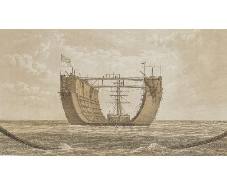
Lot 22
BERMUDANarrative of the Voyage of H.M. Floating Dock 'Bermuda,' from England to Bermuda. Written in the Form of a Diary, by One of Those On Board, FIRST EDITION, 4 tinted lithographed plates, one folding lithographed map, errata slip tipped to verso of one map, some toning and off-setting (from plates to text), publisher's blue cloth lettered in gilt on upper cover, worn, rebacked, 8vo, John B. Day, [c.1870]Footnotes:A scarce eye-witness account of the great engineering feat of 'the most important post on the North American and West Indian Station, being for our ships a half-way place of call between our colonies in that quarter of the globe' (Chapter 1).This lot is subject to the following lot symbols: •• Zero rated for VAT, no VAT will be added to the Hammer Price or the Buyer's Premium.For further information on this lot please visit Bonhams.com
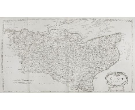
Lot 39
CAMDEN (WILLIAM)Britannia, Newly Translated into English: With Large Additions and Improvements...by Edmund Gibson, engraved portrait frontispiece, 50 engraved double-page or folding maps, 8 engraved plates of coins, several illustrations in the text, neatly repaired tear to map of Worcestershire, occasional very light spotting, later mottled calf, gilt, rebacked, corners bumped and one repaired [ESTC R12882; Chubb CXIII], folio (395 x 240mm.), A. Swalle, A. & J. Churchill, 1695This lot is subject to the following lot symbols: •• Zero rated for VAT, no VAT will be added to the Hammer Price or the Buyer's Premium.For further information on this lot please visit Bonhams.com
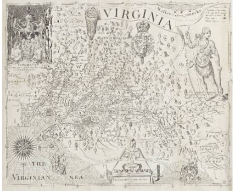
Lot 33
SMITH (JOHN)The True Travels, Adventures and Observations of Captaine John Smith in Europe, Asia, Africke, and America [- A Generall Historie of Virginia, New-England, and the Summer Iles], 2 vol., engraved frontispieces (including portrait of Smith), one folding map of Virginia, 2 folding engraved plates (long tears repaired), contemporary tree calf, red morocco gilt lettering labels on spines, rubbed [Sabin 82852], 8vo, Richmond, at the Franklin Press, 1819This lot is subject to the following lot symbols: •• Zero rated for VAT, no VAT will be added to the Hammer Price or the Buyer's Premium.For further information on this lot please visit Bonhams.com
Lot 75
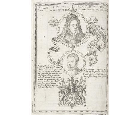
LESLIE (JOHN)De origine moribus, et rebus gestis Scotorum, 2 parts in 1 vol., FIRST EDITION, title with woodcut head-piece and vignette, divisional title with the engraved arms of Mary Queen of Scots on verso, folding engraved map of Scotland, 11 full-page engraved genealogies of the kings of Scotland (incorporating portrait vignettes), woodcut initials and head-pieces, double-ruled borders throughout, light spotting, 2 small worm holes to first few leaves, contemporary limp vellum, manuscript title to spine, light wear [Adams L541; EDIT16 CNCE 33941], 4to (215 x 170mm), Rome, In aedibus populi Romani, 1578Footnotes:First edition of an important history and description of Scotland by the Catholic John Leslie (1527-1596), Bishop of Ross, and adviser of Mary Stewart, Queen of Scots. Although originally composed in Scots during Leslie's imprisonment in 1568-1570, a Scottish version was not published until 1830.Provenance: P. Matthei Paseniy, early ownership ink inscription on title-page.This lot is subject to the following lot symbols: •• Zero rated for VAT, no VAT will be added to the Hammer Price or the Buyer's Premium.For further information on this lot please visit Bonhams.com
Lot 54
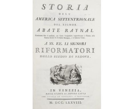
ZATTA (ANTONIO) AND GUILLAUME THOMAS FRANCOIS RAYNALStoria dell' America Settentrionale del Signor Abate Raynal, continuata fino al presente, con Carte Geografiche rappresentanti il Teatro della Guerra Civile tra la Gran Bretagna, e le Colonie Unite, Part 1 only (of 2), FIRST EDITION, engraved printer's device on title, 15 double-page hand-coloured engraved maps, engraved head- and tail-pieces, contemporary decorative paper boards with original printed label on spine, light wear [Phillips Atlases 650; Sabin 68109], folio (430 x 310mm.), Venice, Antonio Zatta, 1778Footnotes:FIRST EDITION OF ZATTA'S MAPS OF THE UNITED STATES, including 12 maps based on Mitchell's Map of North America, intended to be joined to form one large wall-map, and 3 further maps comprising Canada, Newfoundland and Cape Breton, and Hudson's Bay. This copy does not include the second volume of text. This lot is subject to the following lot symbols: •• Zero rated for VAT, no VAT will be added to the Hammer Price or the Buyer's Premium.For further information on this lot please visit Bonhams.com
Lot 23
DOBBS (ARTHUR)An Account of the Countries Adjoining to Hudson's Bay, in the North-West Part of America, FIRST EDITION, one folding engraved map of North America (off-setting), occasional spotting, contemporary calf gilt, spines tooled in gilt within raised bands, joints neatly refurbished [Howes D373; Lande 1144; Sabin 20404], 4to (290 x 220mm.), J. Robinson, 1744Footnotes:Dobbs (1685-1765) had first begun his campaign to find the Northwest Passage in 1731, and helped finance an expedition under the command of Christopher Middleton, a captain of the Hudson's Bay Company. The Account includes Dobbs' first attack in print on Middleton, who he believed was undermining efforts to find the Passage in order to protect monopoly of the Company. The description on Hudson's Bay is based on the account of the French Canadian Joseph La France. The map shows the coastline of America from California in the west, to Greenland in the north and down to New York in the southeast.Provenance: Library of Ragley Hall, seat of the Marquesses of Hertford, bookplate.This lot is subject to the following lot symbols: •• Zero rated for VAT, no VAT will be added to the Hammer Price or the Buyer's Premium.For further information on this lot please visit Bonhams.com
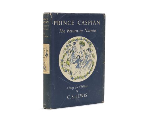
Lot 126
LEWIS (C.S.)Prince Caspian. The Return to Narnia, FIRST EDITION, colour frontispiece, front map endpaper and illustrations by Pauline Baynes, publisher's dark blue cloth (slightly faded at spine extremities), dust-jacket (chipped to head of spine and corners, a few other short marginal tears, spine age-soiled, a few abrasions, ownership inscription dated 1953 inside upper flap), 8vo, Geoffrey Bles, [1951]This lot is subject to the following lot symbols: •• Zero rated for VAT, no VAT will be added to the Hammer Price or the Buyer's Premium.For further information on this lot please visit Bonhams.com
![BEIRUT, PALESTINE AND MIDDLE EASTBaghdad to Beirut 1944 [The Leave Convoy], collates: [2], 18, 2 photographic illustrations,](https://cdn.globalauctionplatform.com/1a910766-0dd9-4936-92b0-b01f00d20207/1897ce24-a8a6-403c-b5a9-b01f00e56e14/468x382.jpg)
Lot 35
BEIRUT, PALESTINE AND MIDDLE EASTBaghdad to Beirut 1944 [The Leave Convoy], collates: [2], 18, 2 photographic illustrations, large folding map 'Baghdad-Beyrouth' (sheet 480 x 580mm.) printed in black and red with Oil Pipe Line in green, pencil annotation ('started somewhere here' next to Malayer on map), publisher's stapled wrappers, ink note 'Souvenir of Trip' on upper cover), 8vo, [No place, or publisher, 1944]--Railway Map of Palestine and Transjordania, map printed in black, blue and red, scale 1:750,000, old folds, 540 x 630mm., Reproduced by Survey of Egypt, [c.1920] (2)This lot is subject to the following lot symbols: •• Zero rated for VAT, no VAT will be added to the Hammer Price or the Buyer's Premium.For further information on this lot please visit Bonhams.com
![[MOLL (HERMAN)Atlas Minor], 62 engraved maps (of 65,mostly double-page including twin-hemisphere world), all with contempora](https://cdn.globalauctionplatform.com/1a910766-0dd9-4936-92b0-b01f00d20207/79ecf9bb-2f88-4772-9d7a-b01f00e57301/468x382.jpg)
Lot 46
[MOLL (HERMAN)Atlas Minor], 62 engraved maps (of 65,mostly double-page including twin-hemisphere world), all with contemporary hand-colour in outline, ink numerals, lacking title-page, map of England laid down with loss of cartouche, light toning, later marbled boards with morocco spine, rebacked [Phillips 585], 4to, [John and Carington Bowles, 1763 or later]Footnotes:The Bowles' post 1763 Treaty of Paris edition of Moll's Atlas Minor.This lot is subject to the following lot symbols: •• Zero rated for VAT, no VAT will be added to the Hammer Price or the Buyer's Premium.For further information on this lot please visit Bonhams.com
![MUNSTER (SEBASTIAN)[Sea Monsters] Meerwunder und Seltzame Their, hand-coloured double-page woodcut by Hans Rudolph Manuel De](https://cdn.globalauctionplatform.com/1a910766-0dd9-4936-92b0-b01f00d20207/33c2b0ff-9b99-4b9d-a005-b01f00e573a5/468x382.jpg)
Lot 47
MUNSTER (SEBASTIAN)[Sea Monsters] Meerwunder und Seltzame Their, hand-coloured double-page woodcut by Hans Rudolph Manuel Deutsch, with text and woodcut map on the reverse, some soiling (mostly affecting margins), neatly restored at central fold and edges, one tear repaired, sheet 300 x 375mm., [1578]Footnotes:Woodcut first published in 1550 in Sebastian Münster's Cosmographiae Universalis, showing North Atlantic sea and land monsters, with deer, foxes, bears, snakes and a leopard at the top, and a wide variety of sea-going creatures devouring boats, swimmers, land animals, and one another, each labelled after Olaus Magnus's Carta Marina of 1539. This example, from the 1578 German edition, is headed with a reference to the Midnight Lands (Scandinavia), captioned 'Morwunder und selczame Thier, wie sie in den Mitnachtigen Länder finden'.This lot is subject to the following lot symbols: ** VAT on imported items at a preferential rate of 5% on Hammer Price and the prevailing rate on Buyer's Premium.For further information on this lot please visit Bonhams.com
![[MOXON (JOSEPH)]Einer Kurtzer Discours von Der Schiff von der Schiff- Fahrt bey dem Nord-Pol nach Japan, China und so weiter,](https://cdn.globalauctionplatform.com/1a910766-0dd9-4936-92b0-b01f00d20207/2d28c675-cb13-4d42-92fa-b01f00d8da16/468x382.jpg)
Lot 27
[MOXON (JOSEPH)]Einer Kurtzer Discours von Der Schiff von der Schiff- Fahrt bey dem Nord-Pol nach Japan, China und so weiter, engraved map (by Wichmann) of the North Pole and the regions near it (Newfoundland, Baffin's Bay, Hudson Straits, Nova Francia, Nova Anglia), woodcut map at end showing Nowaja Semljared, crushed morocco by Sangorski & Sutcliffe, gilt lettering on spine [Sabin 38357, not seen], small 4to (190 x 150mm.), Hamburg, Johann Naumans and Georg Wolffs, 1676This lot is subject to the following lot symbols: •• Zero rated for VAT, no VAT will be added to the Hammer Price or the Buyer's Premium.For further information on this lot please visit Bonhams.com
Lot 19
BELIZE AND MEXICOTratado de limites entre los Estados-Unidos Mexicanos y Honduras Britanica. Edicion Oficial, FIRST EDITION, vignette on title, one folding map of 'British Honduras' printed in colours, contemporary half cloth over marbled boards, gilt lettered on spine, dulled, small 4to, Mexico, 'La Europea' de J. Aguilar Vera, 1897Footnotes:Scarce work detailing the establishment of the fixed Belize-Mexico border.Provenance: Dr. Eduard Seller, Berlin, small blue stamp on title.This lot is subject to the following lot symbols: •• Zero rated for VAT, no VAT will be added to the Hammer Price or the Buyer's Premium.For further information on this lot please visit Bonhams.com
![BERMUDA[WHITTINGTON (FERDINAND)] Bermuda. A Colony, a Fortress, and a Prison; or, Eighteen Months in the Somers' Islands. By](https://cdn.globalauctionplatform.com/1a910766-0dd9-4936-92b0-b01f00d20207/87fd3d4c-1717-4178-9a1e-b01f00d8d1e2/468x382.jpg)
Lot 21
BERMUDA[WHITTINGTON (FERDINAND)] Bermuda. A Colony, a Fortress, and a Prison; or, Eighteen Months in the Somers' Islands. By a Field Officer, FIRST EDITION, engraved hand-coloured map of Bermuda, 8 tinted lithographed plates after daguerreotypes 'executed, for the author, by Mr. Whitmore of the United States', tissue guards, 24-page advertisements (dated November 1856) at end, off-setting onto title, a few small damp stains (including on corners of 3 plates), publisher's brown cloth, spine refurbished with gilt lettering worn [Sabin 4097], 8vo, Longman, Brown, Green [etc.], 1857Footnotes:'Bermuda possesses a three-fold claim to attention of Britons, - as a colony, a fortress, and a prison... as the receptacle of our worst convicts' (Preface).This lot is subject to the following lot symbols: •• Zero rated for VAT, no VAT will be added to the Hammer Price or the Buyer's Premium.For further information on this lot please visit Bonhams.com

Lot 20
BERMUDA - RICHARD HAWKINSKort Berigt van Mr. Ellis, een der Kapiteynen van d'Heer Richard Hawkins, aangaande fijn Reys door de Straat van Magellanes in 't Jaar 1593, engraved vignette on title, engraved folding map of Bermuda [see Palmer, The Mapping of Bermuda, 1983, p.7], some browning and spotting to text, modern wrappers, 8vo, Leiden, Pieter van der Aa, 1706Footnotes:A narrative account of Richard Hawkins' voyage through the Strait of Magellan in June of 1594, and also the wreck of the Sea Venture under the command of Henry May in 1593. The Sea Venture is depicted as a vignette in the Van der Aa's map of Bermuda.This lot is subject to the following lot symbols: •• Zero rated for VAT, no VAT will be added to the Hammer Price or the Buyer's Premium.For further information on this lot please visit Bonhams.com
Lot 52
WILLARD (EMMA)A Series of Maps to Willard's History of the United States, or Republic of America. Designed for Schools and Private Education, 12 engraved maps (5 double-page, all but 2 hand-coloured), publisher's cloth-backed boards printed with title, spine worn, sides damp stained [Phillips 10649; Sabin 104046 (1828 ed.)], 4to, New York, White, Gallagher & White, [1831]Footnotes:The first historical atlas of the United States, produced by pioneering female educator and mapmaker Emma Willard (1787–1870). The first map is titled 'Locations and Wanderings of the Aboriginal Tribes', followed by others showing maps of the North America coast in 1578, 1620, 1692, 1763 through to 1826.This lot is subject to the following lot symbols: •• Zero rated for VAT, no VAT will be added to the Hammer Price or the Buyer's Premium.For further information on this lot please visit Bonhams.com
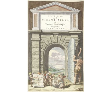
Lot 38
BLAEU (JOAN) AND MARTINUS MARTINI Novus Atlas Sinensis. Seste Deel van de Nieuwe Atlas, engraved hand-coloured allegorical title, 17 double-page hand-coloured engraved maps (16 of China, one of Japan), worming to right margin of title and first map touching text, foxing and some browning throughout, contemporary panelled vellum, gilt-stamped rectangular frames and floral borders encasing a central lozenge-shaped floral ornament, yapp edges, silk ties (some loss), minor repairs, rubbed [Shirley T.BLA1n], folio (540 x 360mm.), Amsterdam, Joannes Blaeu, [1655] Footnotes: FIRST DUTCH EDITION OF THE FIRST EUROPEAN ATLAS OF CHINA. This is the first atlas to include descriptions and geographical coordinates of the fifteen provinces of the Chinese Empire, with the location of the capitals and the precise delineation of the borders. The maps are noteworthy also due to the decorative cartouches featuring vignettes depicting regional dress, activities and animals. The Atlas was based on the travels of Father Martino Martini (1614–1661), a Jesuit missionary in China who made use of 'Chinese materials from a much earlier date, originally an atlas compiled by Chu-Ssu-pên in about 1312' [Shirley p. 241]. The text is Martini's own account of his travels in the Chinese provinces, which took place over a period of roughly ten years. This lot is subject to the following lot symbols: • • Zero rated for VAT, no VAT will be added to the Hammer Price or the Buyer's Premium. For further information on this lot please visit Bonhams.com
![SAUDI ARABIA - HIJAZ, MECCA AND MEDINAHicaz Rehberi [Light of Islam]. Haccin, Faydalari, Yollari..., text in Turkish, illust](https://cdn.globalauctionplatform.com/1a910766-0dd9-4936-92b0-b01f00d20207/bc160813-bcd6-47d3-9b0a-b01f00e56c76/468x382.jpg)
Lot 32
SAUDI ARABIA - HIJAZ, MECCA AND MEDINAHicaz Rehberi [Light of Islam]. Haccin, Faydalari, Yollari..., text in Turkish, illustrations in the text, 2 large folding map plans (the Kabba and place of worship of the Hajj and Umrah; A-Masjid an-Nabawi), and one folding letterpress table loose in pocket inside lower cover, publisher's wrappers, small 8vo, Istanbul, Ismail Akgun Matbaasi, [1952]Footnotes:Rare Turkish-language guide to the Hajj and the Hejaz region, including folding maps of Mecca and Medina, issued for pilgrims, with instructions on suggested route, expenses, etc.This lot is subject to the following lot symbols: •• Zero rated for VAT, no VAT will be added to the Hammer Price or the Buyer's Premium.For further information on this lot please visit Bonhams.com

Lot 602
Laborde, M.Leon de 'Journey Through Arabia Petraea to Mount Sinai and The Excavated City of Petra, the Edom of the Prophecies', 2nd edition, John Murray London 1838 with sixty five plates, in text engravings, folding map, 12pp of publishers ads at end, original blind stamped blue cloth 8vo (220 x 140mm) plus Andrew, William P 'Memoir of the Euphrates Valley Route to India', Allen London 1857, author's inscription, no maps, 8vo. blind stamp green cloth. Both in much used condition, stains, bumps etc bindings loose (2)

-
109198 item(s)/page