We found 109198 price guide item(s) matching your search
There are 109198 lots that match your search criteria. Subscribe now to get instant access to the full price guide service.
Click here to subscribe- List
- Grid
-
109198 item(s)/page


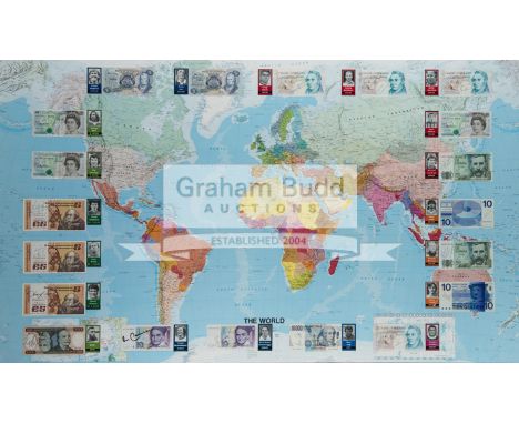
Lot 1161
Signed Footballers of the World framed display,comprising a large scale map of the world applied with 20 banknotes each bearing the autograph of an international footballing legend and accompanied by a portrait card, comprising: Bank of England £5 notes signed by Geoff Hurst, Stanley Matthews, Bobby Charlton and Peter Shilton plus Northern Ireland's George Best & Pat Jennings, and Hungary's Ferenc Puskas; Bank of Scotland £5 notes signed by Kenny Dalglish & Denis Law; Central Bank of Ireland £5 notes signed by Frank Stapleton, Liam Brady & David O'Leary; a Banco Central do Brasil 1,000 Real note signed by Pele; Deutsche Bundesbank 10 Deutsche Mark notes signed by Franz Beckenbauer & Karl-Heinze Rummenigge; a Banca d'Italia 10,000 Lire note signed by Dino Zoff; Nederlandsche Bank 10 Guilders notes signed by Johan Cruyff & Ruud Gullit; and Banco de Espana 1,000 pesetas notes signed by Denmark's Michael Laudrup (Real Madrid & Barcelona) & Holland's Ronald Koeman (Barcelona), framed & glazed, 95 by 153cm.


Lot 1025
Lot of four books. Stoddart's Anglers Companion possibly rebound but front board loose still has original map. The Complete Book of the Dog by Robert Leighton dedication to inside page. Badminton Magazine XV 1902 pencil dedication front board coming away slightly, outer hard cover shows wear to spine ends and corners. Badminton Magazine Vol X 1900 internal repair to front board and a few loose pages.


Lot 1260
Late 19th/early 20th century German hand-coloured map of Scotland, 29cm by 24cm; a pair of 19th century hand coloured ''British Sports and Pastimes'' prints, depicting ''Bowls'' and ''Skittles'', circa 1829 as referenced on framers label to verso, originally from a Sam Maunder publication, 22.5cm by 26cm; together with four other assorted prints (7)


Lot 856
Raleigh (Walter & Jones, H.A.). The War in the Air, Being the Story of the Part Played in the Great War by the Royal Air Force, 9 volumes including 2 map cases and Appendices volume, 1st edition, Oxford University Press, 1922-37, maps and folding plans, original cloth in rubbed and soiled dust jacket and a little chipped at heads, volumes 3 & 5 maps in cloth book boxes, all 8vo (9)

Lot 890
Trevor-Roper (Hugh R.). The Last Days of Hitler, 1st US edition, New York, 1947, portrait frontispiece, map endpapers at rear, 7 related signatures to title-page, original cloth in dust jacket, chipped with some loss to margins, 8vo Signed on the title-page in various pens by: Albert Speer (1905-1981), Hanna Reitsch (1912-1979, Hitler's female test pilot), Otto Gunsche (SS Major and Hitler's personal adjutant) and 4 of Hitler's secretaries: Johanna Wolf, Gerda Christian-Dara, Traude Junge and Christa Schroeder. (1)


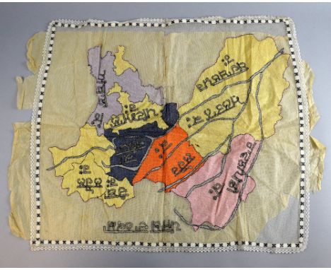
Lot 2090
Embroidered map of the Punjab, with regions named in Hindi, first quarter 20th C,other items to include 3 pairs of shoes, pink salwar kameez and shawl with silver metal tape applique and a map of the Punjab province with regions named in Hindi, embroidered on net . Shoes in good condition, several stains on fabric and areas of discolouration to applique on salwar kameez , shawl with multiple splits. Map in good condition, backing tissue paper still attached
-
109198 item(s)/page