We found 109182 price guide item(s) matching your search

Refine your search

Year

Filter by Price Range
  • List
  • Grid
  • 109182 item(s)
    /page

Lot 345

Lesley Hammet - a canal walk, an oil on canvas, signed lower right hand corner, in a gilt frame, together with a reproduction map of Hereford, a Stanley Orchart print, signed and a J Archer map of Herefordshire

Lot 60

A quantity of mixed prints, watercolours and oils to include a period map of Antigua, together with a wool cross-stitch of a still life

Lot 218

A WWII 'Booklet F, France North Coast':, Coastal silhouette from Port -En-Bessin to St Laurent' published by ISTD February 1944, comprising photogravures of the coast at zero feet, together with 'Flags Maritime Nations' published by US Hydrographic Office and a map of 'Gold Area' printed under the superintendence of Vice Admiral Sir John Edgell.(3)

Lot 491

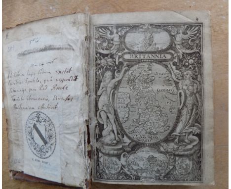
A JACOBITE BRONZE PEACE NEGOTIATIONS AT GERTRUYDENBERG MEDALLION NORBERT ROETTIER (1665 - 1727), STRUCK 1710 Obverse; laureate and armoured bust of Prince James with legend CVIS. EST Reverse; map of Great Britain and Ireland with ships around and motto REDDITE in banner above 38mm across, 20.2g

Lot 157

A collection of vintage ephemera. To include a Walkers Norfolk map 1842; two 1930s driving licences and a 1930s family photo album.

Lot 367

Eman Bowen (English, 1694-1767). An accurate map of Lincolnshire, divided into Wapontakes, hand coloured engraving with armorial reserve to the Most Noble Peregrine Bertie, Duke of Ancaster, 72cm H, 56.5cm W.

Lot 942

A mixed lot of prints including a large monochrome print entitled 'A Private Rehearsal', a reproduction map etc.

Lot 320

Second World War memorabilia to include; Egyptian silk scarf, two Egyptian table decorations, a British military map case of the period, together with a British military compass magnetic marching Mark I of the same period in its original box. (B.P. 24% incl. VAT)

Lot 185

Four vintage car books to include a Triumph Herald owner's manual, The Book of the Standard Vanguard, Standard Cars A Practical Guide Covering All Models from 1936, Motor If You Must by J. B. Boothroyd and a motoring and hiking map

Lot 500

A framed picture mirror of a map of the world together with a metal-legged stool

Lot 5

A LATE 18TH CENTURY MAP SAMPLER 'A Map of England and Wales wrought by Hannah Paine 1784' in period frame

Lot 513

ROBERT MORDEN; MAP OF GLOUCESTERSHIRE, and WILLIAM KIP; STAFFORDSHIRE (2)

Lot 514

A MAP SHOWING ATLANTIC TELEGRAPH LINES, dated 1875

Lot 515

A 19TH CENTURY MAP OF THE WAREHAM AREA

Lot 533

A 19TH CENTURY NAIVE WATERCOLOUR OF A WATERMILL, the mount inscribed 'JOHN VARLEY', and an unframed 19th century map of Dorset

Lot 810

Railwayana - GWR Great Western Railway fold-out GWR system map with original sleeve; booklet map of the Great Western Railway and four 'Holiday Haunts' bookmarks. (6)

Lot 106

Railwayana - GWR Great Western Railway cast iron Weymouth Quay Restriction plate 5in. (22.8cm.), together with a vehicle record road motor engineer's department G.W.R binder; map of the Great Western Railway booklet and folded map of the G.W.R system in original envelope. (4)

Lot 17

A Britains Nestl‚ map of the World cow issued at the 1924 British Empire Exhibition, second version with embossed wording, later reverse painted.

Lot 335

A map of Hartfordshire from the best Authorities, engraved by J. Cary, 15 1/4 x 19 3/4in. (39.4 x 50.2cm.), framed mounted and glazed.

Lot 336

A map of the Island of Guernsey by James Cochrane Junior 1832, dedicated to Lord de Saumarez, Vice Admiral of Great Britain, with vignette of the Royal College of Elizabeth, 22 x 27in (56 x 68.5cm.), framed and mounted. Limited edition print.

Lot 355

British Stamps - Channel Island of Herm collection comprising of mint stamps to include, Pigeon Post, Proofs, Colour Trials, Strike Post, Overprints etc, to include 1949 - Map Definitives (Rouletted); Pigeon Post (Perforated); 1953 - Coronation overprints (Rouletted); 1954 - Pictorials (Crests, Perforated); 6d Claret (Perforated); B.E.A. (Overprint on 2d, Rouletted); Triangulars (Perforated); 1957 - Neolithic Man (Rouletted); Royal Visit July 26th (Overprint, Rouletted); 1958 - Map Definitives (Colour change, Rouletted), 1959, 1960, 1961, 1962, 1963, 1964, 1965, 1966, 1967, etc etc, Some rare stamps. (large quantity)

Lot 541

Abraham Goos (c. 1590-1643) after John Speed (1551-1629) later coloured map of Bermuda Mappa Aestivarum Insularum alias Bermudas ... A Mapp of the Sommer Ilands once called the Bermudas', 15 1/4 x 21in. (38.7 x 53.3cm.), framed and glazed.

Lot 731

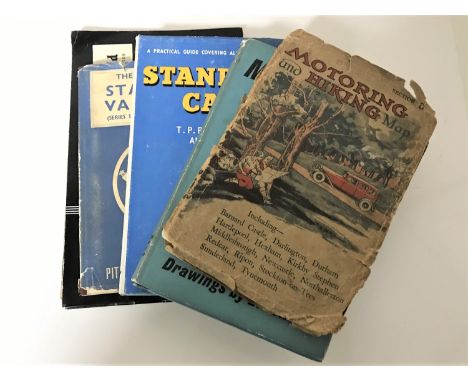
Johnston (Alexander Keith) - The Royal Atlas of Modern Geography, new edition, published W. & A.K. Johnston, 1876, numerous engraved plates - 48 large double page map sheets coloured in outline, contemporary half morocco gilt, spine needing repair, hinges & joints weak and repaired in places, maps/plates good.

Lot 1201

ENGRAVED MAP. folding litho map Viscaya, Bilbao. "Plano de las Minas y vias de trasporte de la zona minerea de Vizcaya." folding linen-backed map, approx 28 x 60 inches, Stanford 1882 good condition.

Lot 1202

ENGRAVED MAP. folding hand col engr map "Amerique du Sud." by A.H. Dufour, folding linen-backed approx 32 x 21 inches, Longuet 1845 good condition.

Lot 1203

ENGRAVED MAP. folding engr map "Surrey" approx 60 x 40 inches, Sifton, Praed & Co., c 1880.

Lot 1231

FREDERICK DE WIT. "Novissima et Accuratissima totius Italiae ..." hand col engr map, 20 x 26 inches, c1680 framed vg.

Lot 1233

RICHARD BLOME. "England Exactly Described." bound fragment incl folding engr map "Cornwal." plus title & 4 Ogilby computed mile charts, tall 12mo late 17C.

Lot 1234

BOWEN & KITCHIN. "A New Improved Map of Hampshire." from the "Large English Atlas", 21 x 24 inches 1764g

Lot 1236

NORDEN & HOLE. "Hamshire, olim pars Belgarum." hand col engr map, 13 x 16 inches, late 17C.

Lot 1237

JOHANNES BLEU. "Somersettensis Comitatas, Somersetshire." hand col engr map, cartouche & armorials, 18 x 20 inches, 1645

Lot 1238

VENICE. engr map hand col in outline with vignette & inset, 18 x 21 inches, SDUK, 1838.

Lot 1240

ROBERT MORDEN. "Cornwall." hand col engr map, 18 x 20 inches, c1695.

Lot 1241

JOHN SPEED. "Invasions of England & Ireland, with al their Civill Wars Since the Conquest." fine hand col engr map with cartouche, compass, shipping etc 19 x 22 inches, 17C Condition report: Good contemporary to Speed.

Lot 1242

THOMAS BOWEN. "The World including the late Discoveries by Capt Cook ..." hand col engr map, f & g, 16 x 20 inches, c1770's vg. Condition report: Nice original condition, wove paper, ex atlas.

Lot 1244

OWEN & BOWEN. "The Road from Exeter to Truro showing Map of Cornwall 1720.

Lot 1247

JOHN SPEED. "Devonshire with Excester Described ..." hand col engr map with plan of the city armorials, cartouche etc, f&g 19 x 22 inches 17C.

Lot 1248

SAXTON & HOLE. "Glocestriae Comitacius olim Sedes Dobunorum." hand col engr map with cartouche, compass etc 14 x 16 inches, early 17C (bottom margin cut with no loss of impression).

Lot 1249

RICHARD BLOME. "A Mapp of Devonshire with its Hundreds." hand col engr map with shipping, cartouche etc 15 x 17 inches c1680

Lot 1251

LAURIE & WHITTLE. "Completion of the Road to Land's End...." hand col engr map 12 x 10 inches 1815; SAXTON & KIP. "Warwici Comitatus a cornauiius olim inhabitatus." hand col engr map (laid down) 17C; plus 18 various loose maps.

Lot 1252

GERARD MERCATOR. "Cornubia, Devonia ..." good hand col engr map, 18 x 20, c1633

Lot 1253

ROBERT MORDEN. "Dorsetshire." hand col engr map, 18 x 20 inches c1695

Lot 1254

ROBERT MORDEN. "Devonshire." hand col engr map, 18 x 20 inches, c1695

Lot 1255

JOHN CARY. "A Map of Cornwall from the best authorities." hand col engr map 20 x 24 inches 1805; plus similar "Somersetshire."; plus one other.

Lot 1267

LIFE BOATS. "Report of the Committee appointed to examine the LifeBoat Models submitted to Compete for the Premium offered by His Grace the Duke of Northumberland ..." 13 folding col litho plts comp, map, wreck chart 77 pp comp, orig cl gt fl, 1851 (inserted is good contemporry manu list "Comparison of Designs for Life Boats." with details of construction)

Lot 1273

CASED MAP. 2 part folding col engr map "Cornwall." E. Stanford, large size, latest date 1898

Lot 1289

DYLAN THOMAS "The Map of Love." 1st edn orig cl,1939 good.

Lot 1309

POLWHELE (REV. RICHARD). "The History of Cornwall." 3 Vols bound in one, complete with the 96 page supplement. folding aquatint of Mount's Bay, folding map & other plts comp, well bound mod 1/2 mor, 4to, 1803-4 vg

Lot 1313

PUBLISHER S. HOOPER. "Cornwall Illustrated." hand col map & 23 engr plts comp, well bound mod 1/2 calf gt, 4to 1786 vg.

Lot 1319

LYSONS (D.& S.). "Magna Britannia." Cornwall. folding map, plts etc comp, cont 1/2 cf, spine loose, thick 4to 1814.

Lot 1324

WILLIAM CAMDEN. "Britannia." woodcut title with royal arms, plus additional woodcut title with map, 3 engr maps comp, other engr plts, 831 pp comp prelims & add pp, old calf gilt, thick 8vo, W. Rogers, 5th edn 1600 good.

Lot 1355

WILLIAM BORLASE. "Observations on the Antiquities Historical & Monumental of the County of Cornwall." 32 engr plts incl map comnp, cont cf recased, folio, 1754 good.

Lot 680

African oil on canvas, world map print, Arsenal wall mirror, three prints (6)

Lot 449

Two gilt framed oval chalk boards; together with a framed map; and a coloured print depicting Sadler Gate 1913

Lot 452

A large black and white map depicting Bristol

Lot 250

A large reproduction map of London, framed and glazed, 82 x 122cm

Lot 642

The Football Association 150th Anniversary Map

Lot 55

FOUR MIXED PICTURES, PRINTS, MAP OF NORFOLK ETC

Lot 71

REPRODUCTION MAP OF NORFOLK

Lot 327

A selection of prints and a county map of Durham

Loading...Loading...
  • 109182 item(s)
    /page

Recently Viewed Lots