
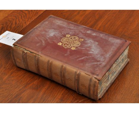
Boswell (James). An Account of Corsica, The Journal of a Tour to the Island, and Memoirs of Pascal Paoli, 3rd edition, corrected, 1769, issued without half-title, engraved portrait frontispiece, folding engraved map, contemporary calf, heavily rubbed, modern reback, 8vo, together with [Beckford, William]. Recollections of an Excursion to the Monasteries of Alcobaca and Batalha. By the author of 'Bathek', 1835, some minor marginal marks, 19th century red stained full calf (by Hayday), some marks and discolouration to covers, spine gilt decorated, 8vo, plus other 18th century English literature, including Samuel Johnson, Prayers and Meditations, 2nd edition, 1785, Thomas Gray, Poems with Memoirs, York, 1775, George Farquhar, Works, 2 volumes, 1772, Foulis Press, Pomponii Melae De Situ Orbis, 1752, Oliver Goldsmith, Life of Richard Nash, 1st edition, 1762, [Hudderford, William], The Lives of Those Eminent Antiquaries John Leland, Thomas Hearne, and Anthony a Wood, 2 volumes, Oxford, 1772 (bound in red full morocco), Francis Bacon, Essays or Counsels Moral and Civil, 2 volumes, 1720, [Hooke, Nathaniel], An Account of the Conduct of the Dowager Duchess of Marlborough, 1742, bound with Remarks Upon the Account of the Conduct of a Certain Dutchess, 1742, etc., mostly bound in contemporary calf, all but one 8vo (15)
We found 109198 price guide item(s) matching your search
There are 109198 lots that match your search criteria. Subscribe now to get instant access to the full price guide service.
Click here to subscribe- List
- Grid
-
109198 item(s)/page
Park (Mungo). Travels in the Interior Districts of Africa: performed under the direction and patronage of the African association... , with an Appendix, containing geographical illustrations of Africa, by Major Rennell, 2nd edition, printed for the author, 1799, half-title, stipple-engraved portrait frontispiece, subscribers' list, 2 leaves engraved music, 2 folding maps (second map with some splits and rebacked), double-page chart, 5 engraved plates including 2 double-page, some spotting and offsetting, ownership signature of Josh. Radcliffe to front free endpaper and his armorial bookplate (Milnsbridge, Yorkshire) to front pastedown, contemporary tree calf gilt, joints cracked and corners bumped, 4to (1)
England & Wales. Moll (Herman), The South Part of Great Britain called England and Wales..., published J & T Bowles, Philip Overton and John King, 1710, [but circa 1730], engraved map on two conjoined sheets, contemporary outline colouring, tables of towns to both vertical margins, slight staining, old folds split with slight loss, strengthened on verso, margins frayed with slight loss, 600 x 955 mm, together with, Delamarche (Charles Francois), Carte des Isles Britanniques qui renferment les Royaumes d'Angleterre, d'Ecosse & d'Irlande..., published Paris, 1780, engraved map with contemporary outline colouring, inset map of the Orkney and Shetland islands, old folds, 545 x 720 mm (2)
Paris. Perrier and Gallet (engravers), Nouveau plan Iten‚raire de la Ville de Paris divis‚ en 12 Arr. avec tous les Edifices publies, published Paris 1829, uncoloured engraved map, sectionalised and laid on linen, publisher's printed label to verso of map, 560 x 890 mm, contemporary card chemise with publisher's printed miniature map on recto, contemporary card slipcase, together with, d'Houdan (Francois), D‚partement de Paris..., 1790, engraved map with contemporary outline colouring, sectionalised and laid on linen, trimmed with slight loss to additional title in upper margin, small holes in linen folds, 500 x 700 mm, with, Pinneti (G.A.F.), Carta Postale e Stradale dell Italia, Correcta e aumentata Dietro la Carta dall'Instituto Geografico del I.R. Stato Maggiore 1821 ed altri Documenti Geografici..., published Artaria & Co., Vienna, 1821, engraved map of the northern half of Italy with contemporary outline colouring, sectionalised and laid on linen, 740 x 780 mm, contained in contemporary marbled card slipcase (3)
Roscoe (Thomas). The London and Birmingham Railway; with the Home and Country Scenes on Each Side of the Line; Including Sketches of Kenilworth, Leamington, Warwick, Guy's Cliff, Stratford, &c..., Assisted in the Historical Details by Peter Lecount, published Charles Tilt, [1839], folding engraved map, hand-coloured in outline with short closed tear, additional engraved title and seventeen engraved plates (including 1 plan), numerous wood engraved vignettes throughout, occasional scattered spotting, all edges gilt, later cloth with morocco title label, 8vo, together with The Railway and the Mine, Lever's Illustrated Year-Book, 1861, numerous black and white illustrations, ex-libris stamp to front endpaper, some minor marks, original gilt-decorated purple cloth, boards slightly rubbed, spine faded and rubbed to head and foot, 8vo, and Pendleton (John), Our Railways, their origin, development, incident and romance, 2 volumes, 1st editions, 1896, numerous black and white illustrations, some minor toning, contemporary uniform gilt-decorated blue quarter morocco, spines slightly rubbed, 8vo (4)

Surrey. Speed (John), Surrey Described and Divided into Hundreds, published John Sudbury & George Humble, circa 1627, uncoloured engraved map, inset vignettes of Richmond and Nonsuch palaces, slight water staining, central fold frayed with slight loss, 385 x 515 mm, English text on verso (1)
Cary (John). Cary's New Map of England and Wales with part of Scotland..., 1st edition, published 1794, title page and dedication, engraved map of England and Wales with contemporary hand colouring and table of explanation, seventy-seven engraved map sheets with contemporary outline colouring, index of places bound at rear, occasional ink marginalia, slight offsetting and dust soiling, text block broken and detached with contents shaken and loose, near contemporary ink ownership signature to front pastedown, near contemporary limp reverse calf, worn, stained and frayed, rebacked retaining remains of old spine, 4to Sold as a collection of maps, not subject to return. (1)
Black (Adam & Charles). Black's General Atlas of the World, published Edinburgh, 1888, colour lithographic frontispiece of 'The Flags of all Nations', some damp staining to gutter margin, fifty-five (complete as list) colour printed maps, index bound at rear, map of Persia with slight ink staining, upper hinge cracked, all edges gilt, contemporary half morocco gilt, stained and worn, spine partially detached, folio (1)
Maps. A mixed collection of approximately 180 foreign maps, mostly 18th & 19th century, engraved and lithographic maps including examples by Migeon, Johnston, S.D.U.K., Bartholomew, Baker and A & C Black, including an uncoloured 18th century 'bible map' of the holy land, various sizes and condition (approx.180)
Bowles (Carington, publisher). Bowles's Post-Chaise Companion; or Travellers Directory through England and Wales: Being an Actual Survey of all the Direct and Principal Cross Roads, with the Milestones Expressed as they stand at Present..., 2 volumes., 2nd edition, 1782, double page engraved map of England & Wales, title page to each volume, index of towns, 200 uncoloured engraved road strip maps, on 100 sheets (complete), circuits of judges bound at rear of volume 1, list of fairs bound at rear of volume 2, boards on volume 1 near detached, boards on volume 2 detached, contemporary green sheep with contrasting morocco gilt labels to spines, worn at head and foot of spine and extremities, 12mo, together with, Paterson (Daniel), A New and Accurate Description of all the Direct and the Principal Cross Roads in Great Britain..., 3rd. edition, 1776, double page engraved map of England & Wales with contemporary manuscript on verso, title page and dedication, index, folding engraved map of the 'Road from London, Bath & Bristol through Shrewsbury to Holyhead', later endpapers, modern cloth with printed paper label to spine, 8vo, with, Cary (G & J, publishers), Cary's New Itinerary or an Accurate Delineation of the Great Roads, both Direct and Cross throughout England and Wales..., 11th edition, 1828, calligraphic title and dedication, publisher's advertisement, numerous tables and lists, six uncoloured folding regional maps, and a folding map of England and Wales, sectionalised and laid on linen contained in pocket at rear of volume, later endpapers, early 20th century cloth gilt, with one other similar, 8vo (5)
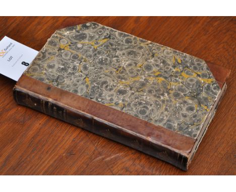
Fontaine (Nicolas). The History of the Old and New Testament, Extracted out of Sacred Scripture and Writings of the Fathers, 3rd edition, printed for S. and J. Sprint et al, 1703, numerous black and white engravings including folding map to rear, some light marks and tears, rebound with modern endpapers, amateur modern half calf with marbled boards, 4to, together with Gay (John), Fables by the late Mr Gay in one volume complete, 1775, numerous black and white plates including frontispiece, ornate contemporary inscription to front endpaper, rebound with modern endpapers, modern calf spine retaining contemporary label and calf boards, 8vo, plus Howell (Laurence), The Ancient and Present State of England. Being a Compendious History of all its Monarchs, from the Time of Julius Caesar, 10th edition, 1742, numerous black and white illustrations including frontispiece, rebound with modern endpapers, amateur rebound calf spine retaining contemporary calf boards, 8vo, plus other 18th and 19th-century historical reference and literature, many leather bindings including some amateur bindings, condition is generally good/very good, 8vo/4to (3 shelves)
Rome. Ritratto di Roma moderna, nel quale sono effigiati Chiese, Monasterii, Hospedali, Compagnie de Secolari, Collegii, Seminarii, Palazzi, Architetture, Librarie, Musei, Pitture..., nuova editione accresciuto, Rome, Francesco Moneta, 1645, additional engraved title, with early ownership signature of J. Sotheby, dated 1687 to upper margin, numerous woodcut engraved and woodcut illustrations to text, endpapers renewed, contemporary calf, modern reback, thick 12mo, together with Guides-Richard. Itineraire Descriptif et Historique de la Grande-Bretagne, Angleterre, Ecosse, Irlande, nouvelle edition, Paris, 1854, 3 folding maps, panorama of London, and engraved plans of Edinburgh, Glasgow and Dublin, some minor marks to margins, original cloth, rubbed and soiled with some marks and upper joint partly split, thick 8vo, plus Corion (A.), Nouveau Plan de la ville de Paris, no date, circa 1840s, hand-coloured engraved map, sectionalised on linen, some minor marks, with original marbled slip case (partly split), 8vo (3)
Cary (John). Cary's New and Correct English Atlas: Being a new Set of County Maps from Actual Surveys..., 1793, general map of England & Wales with long closed tear affecting image, laid on later paper, title page and dedication toned overall and a little frayed at margins, forty-five (complete) engraved maps with contemporary outline colouring, each with tissue guard, maps are a little toned with occasional staining, index bound at rear, last few leaves frayed with slight loss, later marbled endpapers, modern panelled calf with gilt decorated spine, 4to Chubb CCLXI (1)
Rapin de Thoyras (Paul). A collection of thirty-six maps, circa 1750, double page engraved maps by Seale, Bowen and Basire of battle maps and town & city plans showing fortifications, with four regional maps of Germany, a sea chart of the Bay of Biscay and a map of South America, each map approximately 380 x 460 mm, old folds, slight toning, partially disbound, lacking boards but retaining part of spine Sold as a collection of maps, not subject to return. (36)
Wales. Greenwood (C. & J.), Map of the North East Circuit of the Principality of Wales, Comprising of Flint, Denbigh and Montgomery from an Actual Survey made in the Years 1831 & 1832, published Greenwood & Co., 1834, engraved map with contemporary hand colouring, calligraphic cartouche, engraved vignette of St. Asaph's cathedral, (3 copies), some staining and offsetting, two examples trimmed with slight loss to strapwork margins, occasional marginal closed tears, each approximately 625 x 735 mm, together with Map of the County Of Monmouth, from an Actual Survey made in the Years 1829 & 1830, published Greenwood & Co., 1831, engraved map with contemporary hand colouring, uncoloured vignette of Tintern Abbey, long repaired closed tears affecting image, some staining, two worm holes, 570 x 715 mm, with, Map of the South West Circuit of the Principality of Wales, Comprising the Counties of Cardigan, Pembroke and Caermarthen, from Actual Survey made in the Years 1832 and 1833, published Greenwood & Co., 1834, engraved map with contemporary hand colouring, uncoloured vignette of St. David's Cathedral, (2 copies), some staining and offsetting, repaired marginal closed tears, each approximately 610 x 770 mm, plus, Map of the North West Circuit of the Principality of Wales, Comprising the Counties of Anglesey, Caernarfon & Merioneth from Actual Survey made in the Years 1830 & 1831, published Greenwood & Co., 1834, engraved map with contemporary hand colouring, engraved vignette of Bangor Cathedral, some spotting and offsetting, 600 x 680 mm, and Map of the South East Circuit of the Principality of Wales, Comprising the Counties of Glamorgan, Brecon & Radnor, from an Actual Survey made in the Years 1826 & 1827, published Greenwood & Co., 1831, engraved map with contemporary hand colouring, engraved vignette of Llandff Cathedral, slight staining, 620 x 710 mm (8)

Sandys (George). Sandys Travailes: Containing a History of the Original and present state of the Turkish Empire..., The Mahometan Religion and Ceremonies. A description of Constantinople..., 6th edition, London: R. and W. Leybourn, 1668, additional engraved title, folding map and folding view, numerous engraved illustrations to text, early ink marginalia, leaf K2 torn to inner blank margin, dampstaining, soiling and marks throughout, contemporary calf, folio Wing S678; cf. Blackmer 484. (1)
England & Wales. Rocque (John), England and Wales drawn from the most accurate Surveys containing all the Cities, Boroughs, Market Towns & Villages..., published Laurie & Whittle, 1794, large engraved map on two sheets with contemporary outline colouring, large ornate uncoloured cartouche, old folds, short splits along old folds, overall size approximately 1200 mm x 990 mm (1)
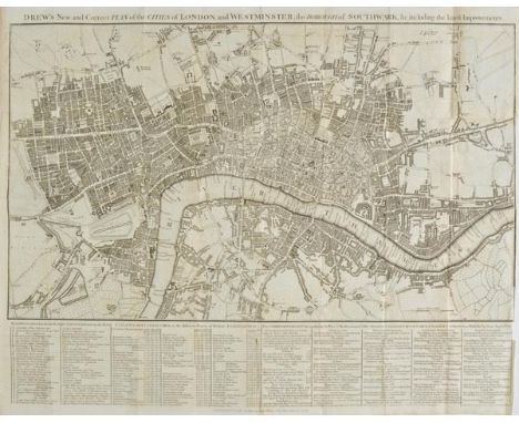
London. Drew (John), Drew's New and Correct Plan of the Cities of London and Westminster, the Borough of Southwark &c. including the latest Improvements, 1799, uncoloured engraved map, scale and note on Hackney carriages below map, old folds, one short split along old fold, 410 x 520 mm Uncommon. Howgego no.218. (1)
*Leicestershire. Speed (John), Leicester both Countye and Citie described, The Honorable Famylies that have had the titles of Earls thereof. With other accidents therein observed, published Thomas Basett & Richard Chiswell, [1676], hand coloured engraved map, inset town plan of Leicester, central fold partially strengthened on verso, 385 x 510 mm, framed and double glazed, English text on verso (1)
Cary (John). Cary's Traveller's Companion or a Delineation of the Turnpike Roads of England and Wales..., 1819, calligraphic title, advertisement, map of England & Wales and forty-two (complete as list) engraved maps with contemporary outline colouring, including one folding (Yorkshire), occasional slight staining, bound with, Cary's New Itinerary or an Accurate Delineation of the Great Roads, Both Direct and Cross throughout England and Wales..., 8th edition, 1819, calligraphic title, folding engraved map of England & Wales with contemporary hand colouring, with long repaired closed tear, with six engraved folding maps with contemporary outline colouring, index bound at rear, later endpapers, modern quarter calf gilt with marbled boards, 8vo (1)
Italy. Ortelius (Abraham), Tusciae Antiquae Typus..., circa 1624, engraved map with outline colouring, occasional marginal closed tears, not affecting image, slight staining in margins, 325 x 480 mm, Latin text on verso, together with Patavini Territorii Corographia IAC Castaldo Auct., [1588], uncoloured engraved map, 310 x 220 mm, Spanish text on verso, The first map described. Marcel van den Broecke. Ortelius Atlas Maps, no.208. (2)
![*Italy. Speed (John), Italia newly augmented by J.Speede, published George Humble, [1627], engraved and hand coloured 'carte-](https://cdn.globalauctionplatform.com/57215a7a-30d8-4d40-a68e-a61d00a89a2c/6541947f-f3c8-455a-9a6b-3b8ff346ab2f/468x382.jpg)
*Italy. Speed (John), Italia newly augmented by J.Speede, published George Humble, [1627], engraved and hand coloured 'carte-a-figures' map, eight costume figures to vertical margins and six oval vignettes of principal cities to upper horizontal margin, trimmed with loss to strapwork margins, laid on card, 390 x 505 mm, framed and glazed (1)


GREENVILLE COLLINS MAP. A hand coloured, engraved map 'The Islands of Scilly', by Captain Greenville Collins, dedicated to His Grace, Henry Duke of Grafton. 46 x 59cm. PLEASE NOTE: Our in-house, postal shipping service is NOT available for this lot, or as part of any multiple lot purchases due to size, weight or fragility. Alternative, recommended carrier services are available.

G. VAN KEULEN MAP. A hand coloured, engraved map of the west side of Cornwall 'Falmouth to St. Ives', by Nicholas de Vries & published by G. van Keulen. 50 x 59cm. PLEASE NOTE: Our in-house, postal shipping service is NOT available for this lot, or as part of any multiple lot purchases due to size, weight or fragility. Alternative, recommended carrier services are available.
Wild, J & Hewitt N. R. (engraver) - A General Atlas, pub. Edinburgh, John Thompson (c.1830), 4to, missing front cover, to/w various loose map engravings Condition Report About 42 maps in total There are also loose maps in the lot of Europe, the World, Africa, Scandinavia Published post 1827 Arctic Expeditions but book not dated


Edwards (Lionel) Famous Foxhunters, 4to, half vellum, frontispiece & plates (some coloured), no. 58 of 100 copies, signed by the author, London & New York, 1932; Osbaldeston (George) Squire Osbaldeston, his Autobiography, 4to, cloth, frontispiece & plates (some coloured), folding map, London & New York, 1926. (2)

The medals and military ephemera of Major William Johnson MC, 8th Batallion Durham Light Infantry, to include: First World War medals of War Medal, War Star, Victory Medal with oak leaf and Military Cross (London Gazette 14th January 1916, no citation), in a metal frame with "DLI" badge mount; a quantity of miniature medals for First, Second World War and a Royal Observer Corp Medal; ephemera, to include: indenture of commission date 26th March 1913, certificate (copy) of marriage rates; a map of Dunkirk dated 1917, letter of resignation dated 15th March 1921, telegram of permission to re-enlist date 6th November 1939, various family and military photographs, First World War period military Christmas cards, etc. NOTES AND LITERATURE William Johnson, son of William Johnson of Trench Hall, Ravensworth, Gateshead, joined the Durham Light Infantry in the 8th Batallion on 26th March 1913, promotions, Lieutenant 29th August 1914; temporary Captain 11th June 1915-1st June 1917; Captain 11th April 1917; acting Major 12th December 1918 resigned 16th March 1921 with rank of Major; re-joined the same Batallion as a territorial reserve officer and relinquished commission due to ill health in 5th June 1940. He served in France and Belgium from the 18th April 1915, was awarded the Military Cross without citation. He can be seen in a group photograph illustrated in E.Hardinge Veitch "8th Batallion Durham Light Infantry 1793-1926" back row third from left (copy included in lot). Mentions also in pages 42, 43 and 81.


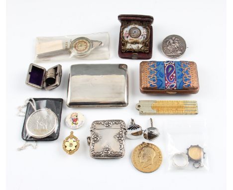
A lot to include a silver cigarette case, hallmarked Birmingham 1918, with makers mark HM for Henry Matthews, weight approx. 93g, a silver vesta case, hallmarked Birmingham 1906, with makers mark HM for Henry Matthews, weight approx. 34g, a travel clock with enamelled surround featuring classical figures and cherubs, (A/F), a Aronsberg of Liverpool bone folding ruler with white metal hinges, a glazed mouted enamel and gilt 1887 Victoria shilling, a mounted George IV 1821 crown, two white metal rings, a thimble, a jubilee crown, a George V coronation commemorative medal, two badges, a pair of cufflinks, a map measurer, a fabric and metalwork purse, (16).


-
109198 item(s)/page