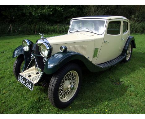

- 1 of approximately 10 survivors known to the Riley Register It was its model 9 of 1926 that really put Riley on the map which, thanks to its lusty 1087cc twin-camshaft engine, soon found success in competition, further boosting the order book. This splendidly-presented Kestrel variant features Cream over Green bodywork and a Green hide interior, and rides on Cream-painted wired wheels. It was evidently restored some 15 years ago and, following a period of regular use, has been dry stored since 2012. The engine has been uprated to 'Merlin' specification courtesy of high-lift camshafts, Omega pistons and twin carburettors and drives through a manual, 'all helical' gearbox. 'ASJ 214' benefits from the recent fitment of new brakes, Blockley tyres and inner tubes and is being offered complete with tool kit, manuals and spare parts. The vendor currently rates the bodywork (complete with sliding sunroof), two-tone paintwork and transmission as 'excellent', and enhanced engine and leather interior trim as 'superb'. This delightful Riley currently displays an unwarranted mileage of 57,000.
We found 109198 price guide item(s) matching your search
There are 109198 lots that match your search criteria. Subscribe now to get instant access to the full price guide service.
Click here to subscribe- List
- Grid
-
109198 item(s)/page
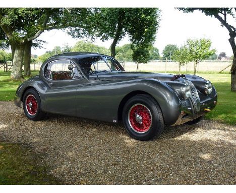
- Beautiful example built to exemplary standards by John May - Competed in the 'Daily Express' Production Jaguar race at the Silverstone Classic in July 2009 - 3.8 litre engine with semi race camshafts & 3x HD8 SU carburettors, E-Type (4.2) all synchro gearbox In addition to maintaining the factory XK 120's for many years and providing the basis for the Nigel Dawes series, John May has been creating his own interpretations of the ideal XK Jaguar for several decades. Today, he is no longer accepting new work. It is not simply that his cars are built to exemplary standards and incorporate the fruits of his vast experience of the marque, it is his uncompromising determination to get the detail of the job absolutely right which makes his output special. 679351 left Brown's Lane in 1952, bound for the US. By the late 1990's it had found its way back to Tewkesbury and underwent a painstaking bare chassis restoration. The detailed specification was formulated with occasional competition in mind, but principally, to serve as a long range tourer. It was finished in 2000. In the early years following the completion of its build, the car took part in the road going class of a few XK races, only failing to finish once (when the driver broke the gearstick and got fed up driving around in second gear). It was always driven to and, importantly, back from the circuits at which it competed, never suffering an impact. Its only 'competitive' outing in the past 10 years came as the result of an invitation to take part in the 'Daily Express' Production Jaguar race at the Silverstone Classic in July 2009, a one off race staged to celebrate the 60th anniversary of the XK's first competition victory at Silverstone in 1949. A commemorative plaque from this event is fitted to the dashboard. Although it has had limited use, the car has been maintained by John. Finished in Jaguar Gunmetal Grey with red leather and Turrino 5 ¢ x 15" colour coded wheels with polished alloy rims laced in E-Type offset pattern, the car's enviable specification includes fixed quarter lights and rear windows, minimalist custom indicators, halogen headlights, rack & pinion steering, modified suspension geometry, adjustable telescopic dampers all round, uprated springs and torsion bars, Salisbury 4HA axle with Powr lock differential and 3.05:1 'touring' ratio, disc brakes all round with Alcon 4 pot front callipers, custom made rear anti roll bar, Dave Butcher E- type 3.8-litre engine with semi race camshafts and 3x HD8 SU carburettors, E- type (4.2) all synchro gearbox, XK 140 radiator electric fan with viscous coupling, alternator, sports exhaust with removable rear baffles, side mounted aluminium water header & oil catch tanks, bucket seats - position adjustable, 4 point harnesses, full leather trimmed roll cage, competition pedal box, leather trimmed dash, doors and rear parcel shelf and battery box, full instrumentation including map light and period aviation chronometer, period Motorola radio (display only), 2 speed wipers and electric screen wash, wood rim steering wheel, plumbed in fire extinguisher (unused), ignition cut out, burst proof aftermarket locks and leather edged carpets. This stunning XK, ready to be enjoyed and worthy of close inspection, is offered with Swansea V5C, detailed specification sheet, Jaguar Cars vehicle information sheet, invoices from XK Developments and assorted old MoTs.


A 1837 map of the River Severn extending from near the Lower Parting in the County of Gloucester to Gladder Whitehouse Brook in the County of Worcester, showing the proposed cuts for canals and the sites of the proposed locks and views for improving the navigation of the same. The survey was made under the direction of Thos Rhodes C.E.M. Inst. C.E, drawn and engraved for the Severn Navigation Company, inscribed to rear Gloucester and Berkeley Canal Company. Also included is a copy of The Severn Navigation Bill and the Parliamentary Alleged Objections and Answers


HASTED (Edward) The History and Topographical Survey of the County of Kent, first edition, in 4 vols., Canterbury: for the author by Simmons and Kirkby, 1778-1799, folio, folding engraved map hand-coloured in outline, plans, plates and illustrations all as called for in each volume, occasional foxing or staining, later half morocco bindings
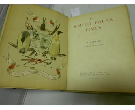
South Polar Times, vol. III only, 1914, edited by Apsley Cherry-Garrard, a 'presentation copy' from an edition of 350, numerous colour and black and white illustrations, scattered light foxing, some mainly marginal age discolouration, the collated contents now working loose in poor damaged original covers, a.e.g.; LEWIS (Samuel) A Topographical Dictionary of Wales, in 2 vols., 1833, 4to, folding map of Wales and twelve engraved county maps, foxing and offsetting, largely unopened, contemporary cloth; another (4)

![[CRAIK (GEORGE)] The New Zealanders, 1833, 12mo, first edition, engraved map, illustrations as required, slight offsetting on](https://cdn.globalauctionplatform.com/953a0e7a-3440-4389-8efe-a52100d2ce70/0df4d1bf-38b0-485c-f34c-98dbd6562723/468x382.jpg)

WAKEFIELD (Priscilla) The Traveller in Asia: or, a Visit to the... East Indies and China, 1817, 12mo, folding engraved map with small tears, title a little stained, leaf of advertisements at end, rebacked; WEEDON (Thornhill) Queensland Past and Present, 1897, signed by the author, faded cloth spine; CRAWFORD (James C) Recollections of Travel in New Zealand and Australia, 1880 (3)


![[J & W Blaeu], Anglia Regnum, engraved map of England and Wales, armorial title cartouche and royal coat-of-arms, with partia](https://cdn.globalauctionplatform.com/953a0e7a-3440-4389-8efe-a52100d2ce70/3b7142f4-a26e-4c03-fe0f-cfd9f796679b/468x382.jpg)


After Giacomo Filippo Ameti, Il Lazio, con le sue piu cospicue Strade Antiche e Moderne e principali Casali, e Tenute di esso. Parte prima Terrestre. hand coloured engraved map by Rossi 1693 or later, 43 x 57cm; with two coloured engravings of Polish figures, and a plan of Warsaw published by Baldwin & Cradock, 1831 (4)


C & J Greenwood, Map of the County of Cambridge; Map of the County of Hertford; Map of the County of Buckingham, hand coloured stipple engravings by J & C Walker, 1834, 57 x 71cm, 61 x 70cm and 63 x 77cm (sheet); and Emanuel Bowen, An Accurate Map of the County of Huntingdon, 18th century engraving with outline hand colour published by Bowles, 75 x 58cm (4)


OGILBY (John) and John SENEX An Actual Survey of all the Principal Roads of England and Wales, Vol. I, London 1719, 8vo, double page title and dedication, 54 road maps, detached worn boards; CARY (John) New Itinerary: or an Accurate Delineation of the Great Roads, London: G. & J. Cary, 1821, ninth edition, 8vo, 8 folding maps including general map, damaged detached binding; together with a silk map of England and Wales by Thomas Jefferys, publ. Sayer & Bennett 1775, entitled 'Itineraire Anglois', few tears, linen backed; one other folding map by Cary (4)

A New and Accurate Map of the Country around London, folding hand coloured engraved map, c.1777, 125 x 135cm (torn along folds, incomplete and stained); together with a collection of coloured prints and engravings, including: W. F. Schlotterbuck 'Bey den Wirthshausen im Pratter', coloured aquatint, trimmed, 26 x 29cm; others mainly 19th century
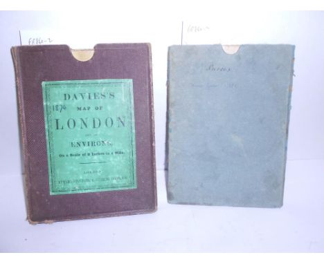
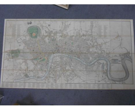
DAVIES'S Map of London and its Environs, scale 2 inches to a mile, folding engraved hand coloured dissected map in cloth case with original label, published by Stanford 1874, slight staining and tears to one or two folds, 74.5 x 107cm; GREAM (Thomas) A Topographical Map of the County of Sussex; Reduced from the Large Survey in Four Sheets, folding dissected hand coloured map, plain card slipcase, W. Faden, 12th August, 1799, 37.5 x 80cm (2)
CARY (John) New and Accurate Plan of London and Westminster, the Borough of Southwark and parts Adjacent.., on a Scale of Six inches and a half to a Mile.., 1820, engraved folding map with original hand-colouring, 82 x 155cm, dissected and linen-backed, some slight age staining, folding into contemporary marbled slipcase with publisher's printed label (case rubbed)
Folding maps. CARY (John) Map of England and Wales, 1813, hand coloured engraved folding map, dissected and linen backed (some general age browning); together with various early 20th century folding touring maps, mostly Ordnance Survey or Bartholomew, mainly of Britain, and including geological maps of London District 1927, and England and Wales by Stanford 10 miles to 1 inch, 1948 (quantity)
-
109198 item(s)/page