We found 109182 price guide item(s) matching your search

Refine your search

Year

Filter by Price Range
  • List
  • Grid
  • 109182 item(s)
    /page

Lot 12

France. Donnet (Alexis). Carte topographique minéralogique et Statistique de la France réduite de celle de Cassini, a l'échelle de 1/388,800..., Paris: Hyacinthe Langlois, 1817, engraved title, Tableau provisoire and uncoloured engraved map on 24 numbered sheets, including final Tableau Statistique et administratif de la France, plus unnumbered d'Assemblage, marginal tears without loss to no. 9 with old tape remains to verso, some dust soiling and a few scattered minor marginal splits, 19th-century cloth backed marbled boards with leather spine label, rubbed and slightly soiled, oblong atlas folio (53 x 73 cm)Qty: (1)

Lot 14

Gell (Sir William). The Itinerary of Greece; containing One Hundred Routes in Attica, Boeotia, Phocis, Locris, and Thessaly, 1st edition, London: Rodwell and Martin, 1819, engraved folding map frontispiece, toning, a few marks, contemporary half calf, label renewed, 8vo (18.6 x 10.8 cm)Qty: (1)NOTESProvenance: 1) Robert Finch (1783-1830), antiquary, connoisseur of the arts, and 'pretentious ass' (ODNB), with his bookplate; bequeathed by him to the Taylor Institution, University of Oxford (relevant bequest label and deaccession stamp to front pastedown). 2) Malcolm Rogers CBE FSA (1948-), British art historian and director of the Museum of Fine Arts, Boston from 1994 to 2015. Blackmer 664. Uncommon. 'The work is not to be confused with Gell's Itinerary of Greece, 1810, which is a description of the Argolid only' (Blackmer).

Lot 16

Hawks (Francis L.). Narrative of the Expedition of an American Squadron to the China Seas and Japan ... under the command of Commodore M.C. Perry ..., volume 1 only (of 3), Washington: A.O.P. Nicholson, 1856, 88 lithographed plates (of 89), including 2 folding, plus the suppressed bathing plate 'Public bath at Simoda', one folding map (short closed handling tear), four single-page charts, plates generally offset to text, a few with minor spotting or discolouration (mainly to blank margins), 1 with small dampstain to lower outer blank corner, title lightly spotted with repaired tear at foot, hinges cracked, deep maroon half morocco, rebacked, rubbed and a trifle marked, corners showing, 4toQty: (1)

Lot 17

Henwood (William Rory). Report on the Metalliferous Deposits of Kumaon and Gurhwal in North-Western India, 1st edition, Calcutta: Thomas Jones, "Calcutta Gazette" Office, 1855, folding lithographic map with partial outline colouring, 58 x 46cm, a few closed tear repairs to verso with clear tape, both title-pages a little dust-soiled and frayed along fore-edges, final blank present but slightly soiled, several oval ink library stamps of the Patent Office Library to first and last leaves (plus name stamp to map verso), modern morocco-backed marbled boards, slim 8voQty: (1)NOTESThe report largely deals with iron but several pages are devoted to copper ores. WorldCat locates just 5 copies of which 3 are in the UK. The additional title-page indicates that this was published as Selections from the Records of the Government of India (Home Department), No. 8.

Lot 24

Mercator (Gerard) - Ptolemaeus (Claudius). Geographiae libri octo Graeco-Latini, Amsterdam: Cornelis Nicolai (i.e. Claesz) & Jodocus Hondius, 1605, engraved title, engraved half-page portrait of Gerard Mercator, 28 engraved maps by Mercator, all but one double-page, illustrations, Great Britain map with lower corner torn away, occasional small pale marginal water stain, 18th century calf, spine with raised bands, morocco label and gilt decoration, upper cover detached, small wormtrack, edges a little rubbed, folio, 41.5 x 28 cmQty: (1)NOTESKoeman II Me 3 (variant c). The first edition of Ptolemy's Geographia with parallel Latin and Greek text. 'The Ptolemy edition of 1605 is the first work printed in Greek in Amsterdam and a typographic masterpiece.' (Koeman). Gerard Mercator had first engraved the maps for the 1578 edition, adding the single-page map of the Nile delta. Following his death his stock of maps was acquired by Jodocus Hondius in 1604 and together with Cornelis Claesz produced this atlas in 1605.

Lot 28

Stanford (Edward [publisher]). Stanford's Compendium of Geography and Travel, 5 volumes, (Asia, by Augustus H. Keane, 1882, North America, by F. V. Hayden & A. R. C. Selwyn, 1883, Australasia, by A. R. Wallace, 1884, slight tear to head of the spine, Africa, by Keith Johnston, 1884, Europe, by F.W. Rulder and Geo. G. Chisholm, 1885), numerous monochrome illustrations & colour maps, some folding maps with marginal wear, some light marks & toning, gutters slightly cracked, all in publishers original gilt decorated green cloth, boards & spines slightly rubbed to head & foot, contemporary & rubbed labels to the spines, 8vo, together with; Napp (Richard), The Argentine Republic, 1st edition, Bueno Aires: Sociedad Anonima, 1876, 4 folding tables, 5 colour & monochrome folding maps to the rear laid to cloth, some light spotting throughout, contemporary red half morocco bound by William Denny & Brothers, boards slightly marked & rubbed to head & foot, 8vo, and Pennell (T. L.), Among The Wild Tribes of The Afgan Frontier..., 1st edition, London: Seeley & Co., 1909, 35 black & white illustrations and map, colour folding map to the rear rubbed & torn, period inscription to the front pastedown, tape to front & rear gutters, ex-library plate to the rear pastedown, some light toning & spotting, contemporary gilt decorated green cloth, boards & spine rubbed & marked, 8vo, plus 12 further volumes of 19th & early 20th century travel reference, all original cloth, 8voQty: (19)

Lot 290

Eyre-Todd (George). The Book Of Glasgow Cathedral a history and description, limited edition, Glasgow: Morison Brothers, 1898, signed to the limitation page, numerous black & white illustrations, bookplate to front pastedown, some minor spotting & toning, top edge gilt, publishers original gilt decorated brown cloth designed by Talwin Morrisboards lightly rubbed, spine slightly rubbed with small tear to the foot, large 4to, limited edition of 1000 copies (un-numbered), together with; Fuller (John), The History of Berwick Upon Tweed including the villages of Tweedmouth and Spittal, &c., Edinburgh: printed for Bell & Bradfute et al, 1799, 7 engraved plates plus fold map, bookplate & previous owner inscription to the front pastedown, cracked gutters, some spotting & toning throughout, contemporary full calf, boards & spine rubbed, 8vo, and Maxwell (Herbert), The Story Of The Tweed, limited edition, London: James Nisbet and Company, 1903, 21 monochrome plates by D. Y. Cameron, bookplate to front pastedown, endpapers spotted, some light toning, top edge gilt, publishers original gilt decorated green cloth, boards & spine slightly rubbed, folio, 197/375, plus other 19th century & modern Scottish topography & history including The River Clyde and THe Clyde Burghs..., by James D. Marwick, Glasgow: James Maclehose & Sons, 1909, mostly original cloth, some in dust jackets, G/VG, 8vo/folioQty: (5 shelves)

Lot 295

Deydier (Christian). Les Bronzes Archaiques Chinois, Archaic Chinese Bronzes, I, Xia & Shang, Paris, Les Editions d'Art et d'Histoire, 1995, colour and monochrome illustrations, original green cloth in dust wrapper, 4to, VG, together with: Salter (John). Wine Labels 1730-2003, A Worldwide History, Antique Collectors' Club in Association with the Wine Label Circle, 2004, several colour plates, numerous monochrome illustrations, original blue cloth gilt in dust wrapper, 4to, VG, plus: White (George). English Lantern Clocks, 1st edition, Antique Collectors' Club, 1989, 8 colour illustrations and numerous monochrome illustrations, original blue cloth gilt in dust wrapper, 4to, and other art and antiques reference, history of map making, etc., including Ashley and Miles Baynton-Williams, New Worlds, Maps from the Age of Discovery, Quercus, 2006 & Maps of War, Quercus, 2007, Louis Lawrence and Shep Brozman, Japanese Inro from the Brozman Collection, 1993, London Delftware, by Frank Britton, 1987, Antique Medical Instruments, by Elisabeth Bennion, Sotheby/University of California Press, 1979, The Brass Book by Peter, Nancy and Herbert Schiffer, 1978, etc., mostly original cloth, many in dust wrappers, mainly 4toQty: (6 shelves)

Lot 30

Ashmole (Elias). The Antiquities of Berkshire, 3 volumes, W. Mears and J. Hooke, 1723, printed title to each volume, lacking portrait of the author, folding engraved county map by John Overton showing a panorama of Windsor Castle by Wenceslas Hollar, bound with the appendix containing eleven folding genealogical pedigrees, some spotting throughout, contemporary mottled calf gilt, rebacked with gilt-decorated spines and red morocco labels, 8voQty: (3)NOTESThe folding map is in very good, undamaged condition.

Lot 315

Kazhdan (Alexander P. [editor]). The Oxford Dictionary of Byzantium, 3 volumes, 1st edition, Oxford: University Press, 1991, some light marks to text-block of volume 2, publishers uniform blue cloth, 8vo, together with; Bury (J. B.), The Cambridge Medieval History, 7 volumes, 1st edition, Cambridge: University Press, 1911-32, some light toning & spotting, publishers uniform original green cloth, top edges gilt, spines slightly faded & rubbed to head & foot, 8vo, includes 7 map volumes, and Dalberg-Acton (John Emerich Edward 'Lord Acton'), The Cambridge Modern History, volumes 13 volumes, mixed editions, Cambridge: University Press, 1902-12, numerous colour maps to the Atlas volume, some minor toning throughout, top edges gilt, publishers uniform original blue cloth, volume 1 rear board rubbed & water stained with heavy damage, 8vo, plus other Byzantium, medieval & miscellaneous history reference, including The Left Book Club, 73 volumes, all original cloth, some in dust jackets, G/VG, 8voQty: (5 shelves )

Lot 32

Barrett (William). The History and Antiquities of the City of Bristol ..., Bristol: William Pine, [1789], folding engraved map, with short closed hanlding tear (with old repair), title with early ink mansucript name at head (George Cox) and small hole centrally (affecting one letter), 28 engraved plates (correct as list), including 14 folding, generally offset, with variable spotting and toning, one folding plate with dampstain to right blank area/margin and fore edge frayed, one index leaf nearly detached, blank area of final printed leaf plus rectos only of the two final blanks and rear free endpaper all with red & black ink manuscript continuation of the list of Mayors and Sheriffs, from 1789 until 1892-93, armorial bookpate of George Cox, hinges strengthened, contemporary mottled calf gilt, rebacked and recornered, worn, with loosely inserted Christmas card from the Lord Mayor and Lady Mayoress of Bristol, dated 1940, containing reproduction of a 1785 engraving, and an associated poem printed on a single sheet, 4to, together with: Evans (John), A Chronological Outline of the History of Bristol ..., Bristol: by the author, 1824, folding engraved map (offset), some spotting and toning, mainly at front, rear and fore-edge, armorial bookplate of William Long, front hinge cracked, contemporary maroon half morocco gilt, rubbed, two corner tips showing, spine faded and lacking label, 8vo, plus five late 19th-early 20th century London atlases, and 36 hand-coloured engravings, some window-mounted, including 29 published in Views of the Thames and Medway, by William Tombleson, 1834Qty: (43)

Lot 328

Berkshire. Hollar (Wenceslaus), A New Map of Barkshire with all the Hundreds, Parkes and other Places thereunto belonging, John Overton, circa 1670, hand-coloured engraved map, inset panorama of Windsor Castle, central fold faded and strengthened on verso, additional horizontal fold, slight creasing and mount staining, 365 x 495 mm,Qty: (1)

Lot 33

Bickham (George). The British Monarchy or, A New Chorographical Description of all the Dominions Subject to the King of Great Britain: Comprehending The British Isles, The American Colonies, The Electoral States, The African and Indian Settlemts. And Enlarging more Particularly on the Respective Counties of England and Wales. With Maps of Each County in a New Taste..., To Which is Added Full and Exact Lists of the Navy, the Army, the Officers of State..., The Whole Illustrated with Suitable Maps and Tables..., G. Bickham junr. 2nd edition, 1749, decorative allegorical frontispiece of Britannia, repaired on verso, calligraphic title, folding map of 'The King of Great Britain's Dominions in Europe, Africa and America', and five further maps of England, Scotland, Ireland, The British Isles and a 'Chart of the Sea Coasts', numerous vignettes throughout, lacking the subscriber's list, the folding table and the 48 'birdseye' view maps, contemporary marbled paper wrappers, worn and frayed, folioQty: (1)NOTESChubb. CLXXIX. Sold as a collection of maps, not subject to return.

Lot 331

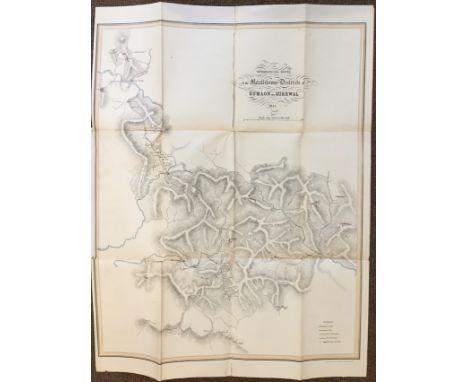
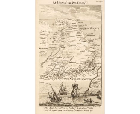
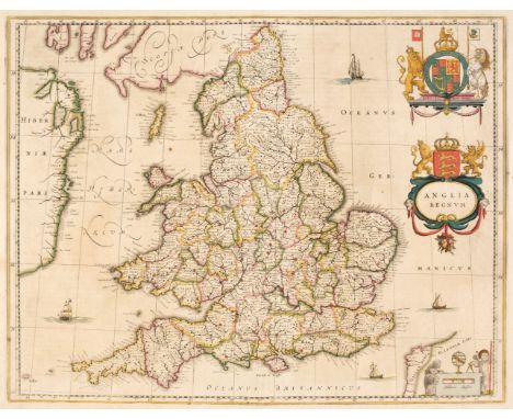
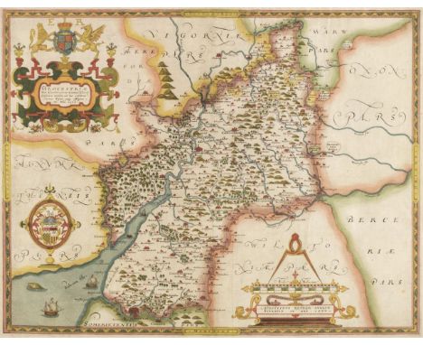
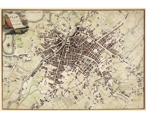
British Isles. Blaeu (Johannes), Anglia Regnum, Amsterdam, circa 1662, engraved map with contemporary outline colouring, slight spotting and dust soiling, upper margin strengthened on recto, 385 x 500 mm, Spanish text on verso, together with Blome (Richard). A Mapp of Staffordshire with its Hundreds, circa 1673, engraved map, hand-coloured in outline, 330 x 245 mm, with Morden (Robert). Cheshire, circa 1705, uncoloured engraved map, 165 x 200 mm, plus Williams (G. Commander, surveyor). Isle of Man, Admiralty chart, 1846, last update 1977, colour photolithographic map, inset maps of Port Erin, Peel, Calf Sound, Castletown Bay, Ramsey Bay & Port St. Mary, the title of each inset map scored through in biro, old folds, slight browning, 1020 x 665 mm and Mount (William & Page Thomas). A New and Correct Draught of the Channell between England & France, shewing ye Sands, Shoales, depth of Water & Anchorage on ye said Coasts with the Setting of the Tydes and the time of High water as observed by Capt. Edm. Halley, circa 1748, an uncoloured engraved chart on two conjoined sheets, inset map of the Scilly Isles, horizon profiles to upper margin, compass rose and numerous rhumb lines, old folds, heavily dust-soiled, some spotting and staining, near-contemporary manuscript annotations to verso, 450 x 815 mm, together with Faden (William). A Map of the Mediterranean Sea with the Adjacent Regions and Seas in Europe, Asia and Africa, 1785, engraved map with bright contemporary hand colouring, large uncoloured allegorical cartouche, 605 x 850 mmQty: (6)NOTESThe Mount and Page chart of the English Channel was an immediate reaction to Edmond Halley's 'Fundamental Thematic Map of the English Channel'. The importance of understanding longitude was well known, but the tidal flow of the seas and their unpredictability was a major navigational hazard resulting in heavy losses of vessels, especially on the approach to harbours and ports. Halley's voyage aboard the "Paramore" in 1701, enabled him to produce a map of the English Channel which for the first time, enabled a prediction of the tides. Its genius was that it made something that was extremely complicated, understandable by 18th-century mariners. Mount & Page published a derivative map in 1702 and this example was published in the 'English Pilot' of 1749.

Lot 332

British Isles. Ortelius (Abraham), Angliae, Scotiae et Hiberniae sive Britannicar: Insularum Descriptio, Antwerp [1608], uncoloured engraved map orientated to the west, large margins, slight creasing, 345 x 500 mm, Italian text on versoQty: (1)NOTESMarcel Van den Broecke. Ortelius Atlas Maps, no16.

Lot 333

British Isles. Sanson (Nicolas), Galliae Antiquae Descriptio Geographica, 1641 or later, engraved map of the southern half of the British Isles with contemporary outline colouring, slight staining and occasional repaired marginal closed tears, 430 x 560 mm, together with De Vaugondy (Robert). Le Royaume D'Angleterre divisé selon les sept Royaumes ou Heptarchie des Saxons avec la Principauté de Galles..., Paris, 1753, engraved map with contemporary outline colouring, large uncoloured decorative cartouche, 485 x 515 mm, with Ortelius (Abraham). Anglia Regnum si quod asiud in toto Oceano ditissimum et florentissimum, [1603 or later], hand-coloured engraved map, large ornate cartouche, several areas of abrasion and loss to paper and printed surface, extensively repaired on verso, the whole backed with archival tissue, 385 x 485 mm, Latin text on verso, plus Munster (Sebastian). De Insulia Britannicis Albione..., Basle [1550 or later], uncoloured woodcut map with Latin text above and on the verso, map size 90 x 150 mm, with another 4 maps of the British Isles, including examples by Bowles, Cary, De L'Isle and Hollar, various sizes and conditionQty: (8)

Lot 334

British Isles. Walker (J & C), Map of the British Isles showing the Cities, Boroughs & Market Towns, the Principal Villages, Railways, Mail & Turnpike Roads, Navigable Rivers & Canals, with the Soundings of Sand Banks round the Coast, W. C. Hobson,1842, large engraved folding map, sectionalised and laid on linen with contemporary hand colouring, inset maps of the Orkney & Shetland Islands and the Channel Islands, calligraphic cartouche, slight finger soiling and staining, 1255 x 995 mm, contained in a contemporary calf gilt book box with contrasting red morocco gilt title label to spine, some wear to the book boxQty: (1)

Lot 336

Carmarthenshire. Speed (John), Caermarden Both Shyre and Towne described, John Sudbury & George Humble, [1627], hand-coloured engraved map, inset map of Carmarthen, large strapwork cartouche and compass rose, very slight dust soiling to central fold, slight marginal staining, 385 x 510 mm, English text on verso, together with Jansson (Jan). Penbrochia Comitatus et Comitatus Caermardinum, Amsterdam, circa 1650, engraved map with contemporary hand-colouring, some browning, 385 x 520 mm, German text on versoQty: (2)

Lot 337

Cary (John). Cary's New Map of England and Wales with part of Scotland on which are carefully laid down all the Direct and Principal Cross Roads, the Course of the Rivers and Navigable Canals..., 1794 [1804], printed title and dedication, title page dust-soiled, a general map of England & Wales with contemporary hand colouring, table of explanation, 77 engraved maps with contemporary outline colouring (numbered to 81), slight offsetting and dust soiling, 'list of places' and advertisement bound at rear, old bookseller's receipt loosely inserted, contemporary boards, crudely re-backed, rear board detached, worn and rubbed at extremities, 4toQty: (1)NOTESThe title page is dated 1794 but the 88 page 'List of Places' bound at the rear was only issued in the 2nd edition of 1804 (Fordham pp 44 - 7) and the advertisement at the rear of the volume is dated May 1804.

Lot 338

Cole (George & Roper John). A collection of 65 county maps, [1816 and later], hand-coloured English and Welsh engraved county maps, occasional duplicates, each approximately 185 x 235 mm, together with Weller (F. S.). A collection of 42 county maps, William Mackenzie, circa 1890, 42 colour lithographic maps, each approximately 230 x 285 mm, with Weller (Edward). A collection of 73 county maps, town plans and regional maps, circa 1890, colour lithographic maps, each approximately 470 x 320 mm, plus Cassell, Petter & Galpin (publishers). A collection of 80 map sheets, circa 1860, uncoloured lithographic maps of railways, counties and regions, each approximately 380 x 320 mmQty: (approx. 260)

Lot 339

Cornwall. Five maps of Cornwall, 18th & 19th century, including Morden (Robert). Cornwell, circa 1701, uncoloured engraved map, old folds, 165 x 215 mm, supplied with four sheets of contemporary descriptive text, together with Kitchin (Thomas). Cornwall drawn from an actual survey and regulated by Astronl. Observatns. B. Baldwin, The London Magazine, circa 1750, uncoloured engraved map, old folds, narrow margins, 205 x 235 mm, with Cowley (John). An Improved map of Cornwall containing the Borough and Market Towns..., Robert Dodsley [1744], uncoloured engraved map, 130 x 185 mm, plus Dury (A.). Cornwall, circa 1764, engraved map with contemporary hand-colouring, 110 x 140 mm, and Johnson (Thomas). Cornwall, [1847], lithographic map with contemporary hand-colouring, some staining to margins, 165 x 230 mmQty: (5)

Lot 340

* Cornwall. Saxton (C & Kip W.), Cornwall olim pars Danmoniorum, circa 1610, hand-coloured engraved map, inset view of Launceston, 305 x 400 mm, mounted, framed and glazedQty: (1)

Lot 341

Dorset. Saxton (Christopher & Lea Philip), Dorsetshire described by C. Saxton. Corrected and Amended with many Additions as Roads &c by P. Lea, circa 1693, uncoloured engraved map, an inset town plan of Dorchester, old folds, three borders with narrow margins, 380 x 540 mmQty: (1)

Lot 343

England & Wales. Dower (J.). A New Map of England & Wales Divided into Counties, Parliamentary Divisions & Dioceses shewing the Principal Roads, Railways, Rivers & Canals and the Seats of the Nobility and Gentry..., Edward Stanford, 1862, large engraved map with bright contemporary hand colouring, sectionalised and laid on linen on two sheets, large calligraphic title, compass rose, table of explanation, a list of proposed ports and table of the Dioceses of Canterbury, very slight browning, edged in green silk, each sheet approximately 1050 x 1700 mm, embossed endpapers, contained in a contemporary morocco gilt slipcase, worn at extremitiesQty: (1)

Lot 344

England & Wales. Seaton (Robert), This New Map of England & Wales, with the adjacent Countries, Compiled by Surveyors Employed in the Ordnance Department, is Respectfully Dedicated to the King by His Majesty's Most Obedient Servant & Geographer...,1835, engraved map with bright contemporary hand-colouring, sectionalised and laid on linen, uncoloured vignette of Windsor Castle, the margins decorated with 4 ecclesiastical engravings and 28 portraits of eminent individuals, edged in brown silk, slight browning, embossed endpapers with some fraying, 1170 x 940 mm, contained in a modern cloth slipcaseQty: (1)NOTESThe four corners of the map illustrate Canterbury Cathedral, York Minster, Westminster Abbey and St Pauls. The portraits are devided by their backgrounds, with military figure along the upper margin and naval figures along the base. The left-hand vertical margin contains politicians and the right-hand, literary figures. Rare.

Lot 345

England & Wales. Walker (J & C), A New Map of England and Wales, with part of Scotland showing the Mail Coach, Turnpike & Railroads, Canals &c. 1839, large engraved map with bright contemporary hand colouring, sectionalised and laid on linen, the map surrounded by numerous distance tables, green endpapers, 1450 x 1030 mm, contained in a contemporary cloth slipcase with contrasting red morocco gilt label to upper cover, slight wear to extremities of slipcaseQty: (1)

Lot 346

Essex. Greenwood (C & J), Map of the County of Essex, from an actual survey made in the year 1824..., Greenwood, Pringle & Co. July 1st 1825, large scale uncoloured engraved map, sectionalised and laid on modern linen on three sheets, calligraphic cartouche, table of explanation, compass rose and a vignette view of Audley End House, later marbled endpapers, modern paper chemise, contained in a modern morocco book-box with contrasting morocco gilt labels to spine, each sheet approximately 1320 x 535 mmQty: (1)

Lot 347

Essex. Speed (John), Essex devided into Hundreds, with the most Antient and fayre Towne Colchester Described and other memorable Monuments observed, G. Humble, circa 1627, engraved map with early hand-colouring, an inset town plan of Colchester, trimmed to neatline and laid on near-contemporary paper, central fold repaired on verso, 380 x 510 mm, no text on versoQty: (1)NOTESThe trimming and re-backing of the map with near-contemporary laid paper, coupled with the early colouring would suggest that this map came from a privately commissioned atlas, whose purchaser requested these particular specifications.

Lot 348

Frankfurt. Munster (Sebastian). Frankfurt an der Oder..., circa 1568, uncoloured woodblock city plan, additional French title above map, slight marginal soiling, French text below and on verso of map, image size 245 x 300 mm, together with Francfurt an der Oder, circa 1790, unattributed uncoloured engraving, originally published in the "Sächsischer Postillion", slight overall toning, 180 x 300 mm, with Bertius (Petrus). Franckfurt an der Oder, circa 1620, uncoloured city panorama, 150 x 195 mm, Dutch text on verso, plus Merian (Mathäus). Gruntrib der belägerung und Statt Franckfurt..., circa 1634, uncoloured engraved city plan showing the fortifications, two short repaired marginal closed tears, 275 x 350 mm, and Gürcsh (C. F.). Schlacht bey Cunersdorf den 12. August 1759, engraved battle plan with contemporary outline colouring, slight overall toning, old folds, 405 x 480 mm, with another six 17th & 18th-century maps and plans of Frankfurt, including examples by Saur, Merian and Romano, various sizes and conditionQty: (11)

Lot 349

Gloucestershire. Saxton (Christopher), Glocestriae sive Claudiocestriae Comitat (Claudy Caesaris Nomine ad huc Celebrat) Verus Tipus atq Effigies. No. Dni. 1577, circa 1579, engraved map with contemporary hand colouring and some later enhancement, engraved by Augustine Ryner, large strapwork cartouche surmounted by the royal crest, mileage scale by dividers, with the coat of arms of Thomas Seckford, slight creasing, central fold strengthened and repaired on verso, a few pin-holes, one repaired small hole, 385 x 495 mmQty: (1)

Lot 351

Hampshire. Speed (John), Hantshire described and devided, Thomas Bassett & Richard Chiswell [1676], hand-coloured engraved map, an inset town plan of Winchester, long repaired closed tear along central fold, slight dust soiling, 380 x 510 mm, English text on versoQty: (1)

Lot 352

Hertfordshire. Speed (John), Hartfordshire Described, The Sittuations of Hartford and the most ancient Towne St. Albons with such memorable actions as have happened, 1st edition, John Sudbury & George Humble, [1611], hand-coloured engraved map, inset town plans of Hertford and Verolanium (St Albans), central fold strengthened and repaired on verso, slight overall toning and mount staining, 385 x 515 mm, English text on versoQty: (1)

Lot 354

* Hungary. (Munster (Sebastian), Landtafel des Ungerlands, Polands, Reussen, Littaw, Walachen und Bulgaren, Basel [1550 or later], hand-coloured woodcut map, slight marginal toning, 320 x 360 mm, mounted, framed and glazed, together with [Schlesia nach Aller Gelegenheit in Stetten...,] circa 1558, hand-coloured woodcut map, mounted to obscure title, 320 x 360 mm, mounted, framed and glazedQty: (2)

Lot 355

Huntingdonshire. Speed (John), Huntingdon both Shire and Shire Towne with the Ancient Citie Ely Described, 1st edition, George Humble [1611], hand-coloured engraved map, inset town plans of Huntingdon and Ely, central fold repaired on verso, slight toning to central fold, slight text 'show through', 385 x 510 mm, English text on versoQty: (1)

Lot 356

Indian Ocean. De Bruyn (Cornelius) Route Exacte de Gamron à Batavia et de Batavia à Gamron, originally published in "Travels into Muscovy, Persia, and part of the East-Indies…", 1737, an uncoloured engraved map showing De Bruyn's route from Gamron (Bandar Abas) to Batavia (Jakarta), compass rise and numerous rhumb lines, large margins, 235 x 305 mmQty: (1)

Lot 357

Isle of Wight. A collection of thirty maps, 18th & 19th century, engraved and lithographic maps, including De Fer (Nicolas). L'Isle de Wight..., circa 1700, hand-coloured engraved map, inset maps of Torbay and the Scilly Isles, one repaired closed tear affecting image, 355 x 320mm, with another copy, laid on later card, together with Brannon (A.). The Map of the Isle of Wight with every information for the Tourist & Pleasure Visitor..., 1862, engraved decorative map, inset maps of Newport, Ryde and Ventnor, old folds, repaired closed tear affecting image, laid on later card, 345 x 440 mm, with Von Reilly (Franz J. J.). Die Insel Wight, engraved map with contemporary outline colouring, circa 1799, 215 x 280 mm, plus Collins (H. G.). Isle of Wight, circa 1852, uncoloured lithographic map, one repaired closed tear affecting image, old folds, slight staining, old ink library stamp to lower margin, 460 x 720 mm, with another 24 maps including examples by Philip & Son, Bacon, Illustrated London News, Laurie & Whittle, Dawson, Rocque, Brannon, Kelly, Moll, Bartholomew and J & C Walker, several duplicates, various sizes and conditionQty: (30)

Lot 358

Isle of Wight. Speed (John), Wight Island, Thomas Bassett & Richard Chiswell, [1676 or later], engraved map with sparse contemporary outline colouring, large margins, slight spotting to margins, near contemporary manuscript title to margin on verso, 385 x 510 mm, no text to versoQty: (1)

Lot 360

Kent. Speed (John), Kent with her Cities and Earles Described and Observed, Thomas Bassett & Richard Chiswell, [1676], hand-coloured engraved map, inset town plans of Canterbury and Rochester, good margins, 385 x 515 mm, English text on versoQty: (1)

Lot 362

Lancashire. Hennet (G.), A Map of the County Palatine of Lancaster Divided into Hundreds and Parishes from an accurate survey made in the years 1828 and 1829, Henry Teesdale and Co. May 1st. 1830, large scale engraved map with contemporary outline colouring, sectionalised and laid on linen, calligraphic cartouche, compass rose, table of explanation, uncoloured vignette of the New Custom House Liverpool, some offsetting and staining, marbled endpapers, edged in green silk, 1615 x 1130 mm, marbled endpapers, contained in a contemporary calf book-box with contrasting modern morocco gilt label to spine, box worn and rubbedQty: (1)

Lot 363

Leicestershire. Speed (John), Leicester both Countye and Citie described, The Honorable Famylies that have had the titles of Earls thereof with other accidents therein observed, Thomas Bassett & Richard Chiswell, 1676, hand-coloured engraved map, inset town plan of Leicester, 380 x 510 mm, English text on versoQty: (1)

Lot 364

Lewis (Samuel). A Topographical Dictionary of Scotland..., with Historical and Statistical Descriptions: Embellished with a Large Map of Scotland..., (supplementary volume only), 1846, title page and contents list, six large engraved folding map sheets with contemporary outline colouring, which if conjoined form a monumental map of Scotland, the map is titled "A Map of Scotland Divided into Counties shewing the Principal Roads, Railways, Rivers, Canals, Lochs, Mountains, Islands &c. on a scale of Five Miles to an Inch", slight offsetting, occasional short closed tears where old folds cross, some repaired on verso, each sheet approximately 650 x 640 mm, contemporary cloth gilt boards, frayed and some wear to spine, slim 4toQty: (1)

Lot 365

Lincolnshire. Speed (John), The Countie and Citie of Lincolne Described with the Armes of them that have bene Earles thereof since the conquest, Thomas Bassett & Richard Chiswell, [1676], hand-coloured engraved map, an inset town plan of Lincoln, wide margins, two small repaired closed teras385 x 510 mm, English text on versoQty: (1)

Lot 366

London. Philip (George & Son, publisher), Philips New Library Map of London and its Environs, circa 1895, large lithographic map, sectionalised and laid on linen with contemporary outline colouring, slight staining, marbled endpapers, 1130 x 1480 mm, contained in a contemporary cloth gilt slipcase, worn and frayedQty: (1)

Lot 367

* Manchester. Dean (R. & W. publishers), A Plan of Manchester and Salford, 1809, hand-coloured engraved map, compass rose and decorative cartouche, 455 x 655 mm, mounted, framed and glazed, together with Baines (Edward). Manchester and its Environs engraved from an actual survey..., by William Swire, Leeds, 1824, hand-coloured engraved map, inset plan of Manchester in 1650, decorated with topographical vignettes and coats of arms, old folds, some spotting, 415 x 520 mm, mounted, framed and glazed, with Hall (Sidney). Bolton, 1824, uncoloured engraved city plan, slight staining, 175 x 250 mm, mounted, framed and glazed plus Morton (W.). A Plan of Manchester and Salford taken in about 1650, circa 1840, hand-coloured engraved plan, toned overall, unobtrusive blind stamp to the upper right corner, 130 x 180 mm, mounted, framed and glazedQty: (4)

Lot 368

Manchester. Laurent (C.). A Topographical Plan of Manchester and Salford with the adjacent parts; shewing also the different allotments of land proposed to be built on as communicated to the Surveyor by the respective Proprietors..., Dec. 9th 1793, large uncoloured folding map, inset strip road map of the route from Manchester to London, inset plan of Manchester and Salford and an inset map of the Country around Manchester, old folds with occasional short splits along the fold, slight spotting and toning, 990 x 920 mmQty: (1)NOTESThe map was used to illustrate Aikin's 'Description of the Country from Thirty to Forty Miles Round Manchester'.

Lot 369

Maps. A collection of 38 British county, regional and country maps, town plans and charts, 17th - 19th century, including Bowen (Emanuel). An Accurate Map of the County of Kent devided into its Lathes and subdivided into Hundreds..., Robert Sayer & Carington Bowles, circa 1765, engraved map with contemporary outline colouring and some later enhancement, trimmed to neat line re-margined, some wear and closed tears, torn with slight loss and replaced in facsimile, 520 x 700 mm, with Ogilby (John). The Road from the City of Salisbury com. Wilts to Campden..., [and] The Road from London to Southampton, circa 1676, one coloured and one uncoloured engraved strip road map, The road from Salisbury to Campden worn and frayed with some loss to the printed surface, laid on later thin card, the road from London to Southampton trimmed to neatline on vertical margins with slight loss to the printed surface, margins extended, each approximately 315 x 465 mm, plus Blaeu (Johannes). Hantonia sive Southantonensis comitatus vulgo Hantshire [and] Vectis Insula, Anglice The Isle of Wight, Amsterdam, circa 1645, two engraved maps with contemporary hand-colouring, worn and frayed with some loss to the printed surface, crudely repaired on verso, 415 x 505 mm, French text on verso with another 34 maps, including examples by Cary, Lodge, Moule, Bowen, Bartholomew, Kitchin, Rocque, Baker, Archer, Weller, Seller/Grose, Henshall, Morden, Munster and Murdoch Mackenzie, various sizes and conditionQty: (38)

Lot 370

Moule (Thomas). Moule's English Counties, 30 parts (only), G. Virtue, 1831, descriptive text and 30 engraved county maps and town plans, some maps with sparse later colouring to the heraldic shields, maps stained and dust-soiled with some marginal fraying, Wiltshire torn with slight loss, lacking some pages of descriptive text, publishers paper wrappers, torn and some covers missing, soiled and frayed, each part 290 x 225 mm, together with Pinnock (William). The Guide to Knowledge, 1832, a disbound periodical containing 53 (only) wood-engraved 'white on black' maps of British counties, foreign countries and celestial maps, each approximately 170 x 235 mmQty: (approx. 83)NOTESThe Thomas Moule maps comprise of - Surrey, Essex, Shropshire, Cambridgeshire, Devon, Norfolk, Gloucestershire, Herefordshire, Buckinghamshire, Nottinghamshire, Boston, Lincolnshire, Rutland, Derbyshire, Durham, Isle of Man, Environs of Plymouth, Northumberland, Bedfordshire, Monmouthshire, Wiltshire, Middlesex, Berkshire, Warwickshire, Northamptonshire, Leicestershire, Worcestershire, Cumberland, Huntingdonshire and a four-sheet map of England & Wales.

Lot 371

Newsmaps. US Government (publisher), prepared and distributed by Army Orientation Course, War department, 102 periodicals, a broken run, 1942 - 46, monotone and colour broadsheets, printed on both sides, many with maps and posters, showing the progress of the war, including Geisel (Theodore, 'Dr Seuss'). This is Ann..., she drinks blood! Her full name is Anopheles Mosquito and she is dying to meet you!...., November 8th, 1943, colour printed photolithographic educational map, with additional maps and photographs on verso, old folds, University of California (Military Department) ink library stamp and red crayon signature to image, 870 x 1190 mm, together with, Heavy Tanks and Self-propelled Artillery, Learn to recognize these vehicles, January 11th, 1943, colour printed photolithographic propaganda and educational poster of tank silhouettes, with additional maps and photographs to verso, four 'punch holes' to margins, old folds, 870 x 1190 mm, with Manning (F.E.), Target Berlin, 'Newsmap', Prepared and Distributed by the Army Orientation Course. Special Service Division Army Service Forces, War Dept., 2E581 Pentagon Bldg., Washington D.C. U.S. Government, October 25, 1943, large photolithographic poster with detachable scale at the base of the map, old folds, 870 x 1190 mm with another 95 Newsmap posters, all with maps and photographs from various theatres of World war II, occasional duplicates, all approximately 870 x 1190 mm, various conditionQty: (102)NOTESNewsmaps were published by the Special Service Division, Army Service Forces, War Department. The issues were prepared and distributed by the Army Orientation Course. One standard feature that appears on all maps is a short textual summary of key events titled The War Fronts, which included descriptions of war-related events, mostly by geographic area, such as China, Russia, Tunisia, South Pacific, Aleutians, Wake, etc. Newsmaps were produced each Monday from 1942-1946 and usually featured a map of the current war fronts on one side and a poster about a war-related topic on the other. They were distributed by the Army and Navy to primarily military installations and government & civilian groups working on War Department projects.

Lot 372

Norfolk. Saxton (Christopher & Lea Philip), Norfolk described by C. Saxton, Corrected and Amended with many Additions of Roads &c. by P. Lea, circa 1693, uncoloured engraved map, an inset town plan of Norwich, old folds, narrow margins on three borders, 335 x 495 mmQty: (1)

Lot 373

Norfolk. Saxton (Christopher), Norfolciae comitatus continens in se Oppida Mercatoria 26, Pagos et Villas625, Una cum singulis Hundredis et Fluminibus in eodem vera descriptio, 1574, [1579], map engraved by Cornelius Hogius with contemporary hand-colouring and some later enhancement, strapwork cartouche and key plate, central fold strengthened and restored on verso, slight toning to central fold, some marginal dust and finger soiling, 330 x 490 mmQty: (1)NOTESThe first engraved county map of Norfolk.

Lot 375

Ogilby (John). The Road from Bristoll to Worcester, [1675 or later], uncoloured engraved road map (complete on one sheet), 310 x 445 mm,Qty: (1)NOTESSheet number 59. The road Commences at Bristol and passes through Dursley, Gloucester, Tewkesbury and Severn Stoke, ending at Worcester.

Lot 381

Ogilby (John). The Road from London to St. Davids in com Pembroke, [1675 or later], uncoloured engraved strip road map, slight marginal water staining, 300 x 440 mmQty: (1)NOTESThe road commences in London and passes through Brentford, Hounslow, Stowe, Maidenhead, Henly-on-Thames, Nettlebed and Dorchester and ends at Abingdon. Sheet 24.

Lot 382

Ogilby (John). The Road from St Davids com Pembroke to Holywell com Flint [and] The Continuation of the Road from St Davids to Holywell, [1675 or later], two consecutive uncoloured engraved strip road maps, narrow margins, slight staining, slight juvenile pencil scribbling to the verso of one map, each approximately 350 x 450 mmQty: (2)NOTESTwo consecutive road maps completing the road from South Wales to Anglesey. Sheet numbers 66 & 67.

Lot 383

* Oxfordshire. Speed (John), Oxfordshire described with ye Citie and the Armes of the Colledges of ye famous University, Thomas Bassett & Richard Chiswell, [1676], hand-coloured engraved map, inset town plan of Oxford, the vertical margins decorated with 18 heraldic shields of university colleges, printers fold to lower right corner, 385 x 530 mm, mounted, framed and double-glazed, English text on versoQty: (1)

Lot 385

* Poland. Chatelain (Henri Abraham), Carte de Pologne avec la Chronologie des Rois et des Ducs de Lithuanie..., circa 1714, hand-coloured engraved reticulated map, with historical and geographical tables, 500 x 595 mm, mounted, framed and glazed, together with Nouvelle Carte Genealogique des Soverains et des Familles Illustres aliez a la Maison quaux decendans de la Famille Roialle de Piaste Roi de Pologne avec le Blason de Leurs Armes [and] Carte Genealogique des Princes et Rois de Pologne...., circa 1714, two large hand-coloured engraved genealogical charts of the Royal families of Poland, old folds, slight toning, each approximately 390 x 925 mm, mounted, framed and glazed, with Carte des Trois ordres qui Composent l'Etat de la Republique de Pologne..., circa 1714, hand-coloured engraved panorama of Cracow with two additional vignette views and descriptive text below images, 355 x 466, plus Nouvell Carte du Royaume de Pologne..., 1714, hand-coloured engraved reticulated map, 505 x 585 mm, and Carte Genealogique de Pologne..., hand coloured genealogical chart, 355 x 450 mm, with two others similarQty: (8)

Lot 386

* Poland. Merian (Matthaus), Polonia Regnum et Silesia Ducatus, circa 1640, hand-coloured engraved map, 275 x 355 mm, mounted, framed and glazed, together with Bowen (Emanuel). A New and Accurate Map of Poland, Lithuania &c. Divided into its Palatinats..., [1744], hand-coloured engraved map, some creasing, left-hand vertical margin trimmed to neatline and re-margined, mounted with another copy similar, each map 350 x 425 mm, framed and glazed, with Van der Aa (Pieter). La Pologne suivant les Nouvelles Observations..., circa 1700, hand-coloured engraved map with an ornate engraved 'picture frame' border, trimmed to the image on the lower border and re-margined, 255 x 380 mm, mounted with another slightly later copy which lacks the picture frame border, framed and glazed, plus Nolin (Jean Baptiste). Carte des Etats de Pologne..., circa 1753, hand-coloured engraved map, old folds, 215 x 300 mm, mounted with another copy similar, framed and glazed and De Vaugondy (Robert). Royaume de Pologne, circa 1795, engraved map with sparse contemporary hand -colouring, mounted with another slightly later edition, each 245 x 285 mm, framed and glazedQty: (5)

Lot 39

Ellis (John). Ellis's English Atlas: or, a compleat chorography of England and Wales: in fifty-four maps. Containing more particulars than any other collection of the same kind. The whole calculated for the use of travellers, academies, and of all those who desire to improve in the knowledge of their country. From the last surveys of the several counties ... Engraved by, and under the direction of, J. Ellis, London: Carrington Bowles, [1768], title with vertical fold and torn with loss of right third (with loss to map index list to verso), 50 engraved maps of 54 each hand-coloured in outline (including 48 double-page & 2 folding, lacking folding general map & 3 others), few marks, occasional spotting and light toning, endpapers renewed preserving early 19th century inscription, contemporary half calf, marbled sides, morocco reback, some wear, 8voQty: (1)NOTESChubb CCXXVIII. Sold as a collection of maps, not subject to return.

Lot 390

Propaganda Map. Manning (F.E.), Target Berlin, 'Newsmap', Prepared and Distributed by the Army Orientation Course. Special Service Division Army Service Forces, War Dept., 2E581 Pentagon Bldg., Washington D.C. U.S. Government, October 25, 1943, large photolithographic poster with detachable scale at the base of the map, old folds, some folds strengthened and repaired on verso, slight dust soiling, 1190 x 890 mmQty: (1)NOTESUncommon.

Lot 391

Propaganda map. Nazi War Aims, Grab! Grab! Grab!!!, That's the Nazi Policy, circa 1940, colour photolithographic British propaganda map based upon a map of Europe showing Germany's expansionist ambitions, old folds, pinholes to each corner, 370 x 495 mmQty: (1)

Lot 393

Railways. Cheffin (Charles Frederick, publisher), London & Birmingham Railway. Plan of the Line and Adjacent Country, Robert Stephenson Engineer, 10th September 1835, large engraved map with contemporary wash colouring, sectionalised and laid on linen, inset maps of Birmingham and the London Depots, panoramic cross-section at the base of the map showing the railways inclination, slight offsetting and dust soiling, slight wear where old folds cross, a few folds crudely strengthened with tape in the margins on the recto, green endpapers, 715 x 1550 mm, contained in a modern marbled card slipcase with morocco gilt label to upper coverQty: (1)

Loading...Loading...
  • 109182 item(s)
    /page

Recently Viewed Lots