We found 108737 price guide item(s) matching your search
There are 108737 lots that match your search criteria. Subscribe now to get instant access to the full price guide service.
Click here to subscribe- List
- Grid
-
108737 item(s)/page


Lot 40
Asian Art Collection. Unusual Drawing of a Character with Dragon Shield and Bonsai Tree Head Wear(with unknown Pencil Signature), A Japanese Lakeside Picture with Gilt Highlights, Thailand Tissue Paper Tracing of a Buddha and Masked Attendant, Another Thailand Framed Print and a Tokyo Bape Map. Tracing is measuring 50cm x 46cm. 亚洲艺术收藏。带有龙盾和盆景树头饰的不寻常人物素描(铅笔签名不详),带有金边亮点的日本湖边图片,泰国薄纸描绘的佛像和蒙面侍者,另一幅泰国裱框印刷品和一张东京 Bape 地图。 Tracing 尺寸为 50cm x 46cm。

Lot 62
London Maps and Transport Timetables 1930's - 1951. Alexander Gross / Geographers' Map Co. - The Authentic Map of London, Olympic Games 1948 Visitors Guide, 1947 Bus Map Central area issue No. 1, 1936-7(Winter) Trolleybus & Tram Map and 1951 Railways Diagram of Lines. Generally good condition with some foxing and stains

Lot 10
Identity Documents in Holland Belgium and Luxembourg (Supreme Headquarters Allied Expeditionary Force Evaluation and Dissemination Section, July 1944. British & US Confidential. Considerable detail and with most documents clearly illustrated in colour ie Buckkehrschein (Return Pass for Workers in Germany). Covers Holland, Belgium and Luxenbourg under German occupation. c. 250pp., loose Restricted areas map for Holland and Belgium tipped-in. Very nice condition.
Lot 130
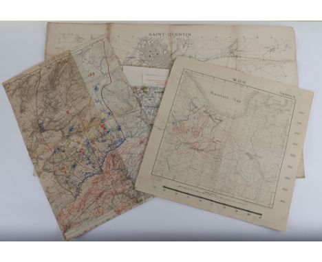
Trench Maps World War One. Unusual original Trench map of Saint Quentin and area around Neuville St Amand, Itancourt and Mezieres covering the area South to below Vendeuil, 1:20,000 with a number of trenches shown, Mars 1917, Published by the French Army, large thick paper map. Together with German Trench map centered on Regnieville, Fey etc with German units added by hand and French gun positions shown, together with dense trench systems, dated 1918 in pencil and Feldart Regt no 95. Note is two spliced together and may have been cut down. Two further Trench maps of the Russian Front produced by the German Army c.1916 with trenches shown, 4 in all.


Lot 30
A Disney California Animation Department Employee Welcome Pack / Handbook. Subsections include details for the some of the following: Frequently Called Numbers, Safety & Security, Helpful Departments, Studio Services. Also included is a production guide, containing production information specific to the animation department, together with a building map, and a administrate and survival guide.


Lot 1478
A 17th century map of the Thames and surrounding area by Captain G Collins, hand coloured, framed & glazed, 98 by 62cms.Condition ReportThe paper is dirty and has yellowed with age, the map has been creased with visible lines both vertical and horizontal, no tears, colour quite strong, Chapman Bros Chelsea Ltd label to verso.


Lot 71
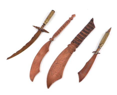
A rare WW1 paper knife inscribed TAHURE, made from an artillery shell drive ring 26cms (10.25ins) long together with three other paper knives or letter openers. Auctioneers note: The village of Tahure was completely wiped off the map during the First World War and its territory was eventually attached to Sommepy in 1950, the new town is called Sommepy-Tahure (4)


Lot 165
Map of the Russian Empire; Publisher DANIEL LIZARS (Edinburgh, 1754-1812), late 19th century.It has damp stains, soiling, cracks and tears on the sides.Measurements: 59 x 90 cm.Map in which the Russian Empire is represented, following the round typology of the terrestrial globe in spite of being a map, characteristic for its two-dimensional idiosyncrasy. This map was edited by Daniel Lizars (1754-1812) who was the son of a shoemaker, but was apprenticed to Andrew Bell, a printer and engraver. Lizars set up his own printing press near St Giles' Cathedral and employed his own apprentices, including George Bartholomew, whose son John would go on to found the important map-making firm later known as John Bartholomew & Son Ltd.

Lot 171
Map of Spain; England, 18th century.Presents damp stains, soiling, cracks and faults on the paper.Size: 22,5 x 32 cm (print); 28 x 39,5 cm (paper).Map of the 18th century of English edition in which the Iberian Peninsula is represented. The map shows the provinces that divided the territory in Roman times: Lusitania, Baetica and Tarraconesis. The peninsula is unified by a single colour, as is the small visible part of Africa, which is shown on the map. France, however, is shown as completely distinct. In the legend at the lower right, which reads 'Ancient Spain', several figures of classical inspiration can be seen, notably the presence of Hercules leaning on one of the mythical columns.
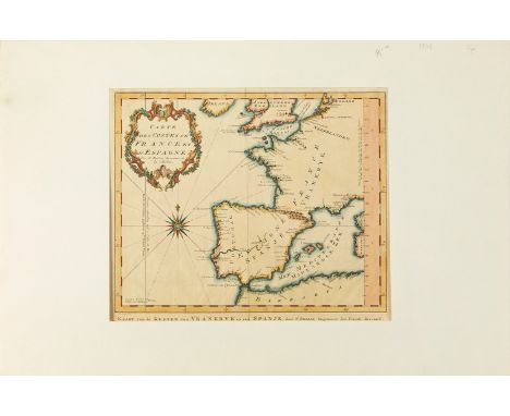
Lot 172
Map of the coasts of Spain and France, 18th century.Colour engraving.Engraver: Jacques-Nicolas Bellin (Paris, 1703-Versailles, 1772).It presents light humidity and dirt stains, wrinkles and folds.Size: 26 x 30 cm (map); 33 x 50.5 cm (passpartout).Jacques-Nicolas Bellin was a French geographer and cartographer. In 1721, at the age of 18, he was appointed hydrographer (chief cartographer) of the French Navy. In August 1741, he became the first Ingénieur de la Marine of the Deposit of maps and plans of the Navy (the French hydrographic office) and was appointed hydrographic officer to the King of France.


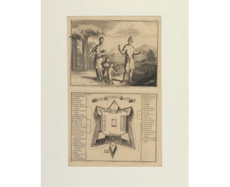
Lot 207
Map of Fort Rotterdam on Macassar and Macassar Family (Indonesia), 18th century.Engraving on paper.Draughtsman and engraver: Ottomar Elliger The Younger (Holland, 1666-1735).Some stains, soiling, damp. Lacking on the sides.Size: 33,5 x 20 cm; 36 x 28 cm (cardboard).Ottomar or Ottmar Elliger the Younger was a painter and engraver born in Hamburg. In Amsterdam he was a pupil of Michiel van Musscher, a portrait painter, and later trained with Gerard de Lairesse. Elliger painted historical subjects in the style of De Lairesse. Like his master, he paid particular attention to the correctness of the costumes and the style of the architecture. He was employed by the Elector of Mayence, for whom he painted the Death of Alexander and the Marriage of Peleus and Thetis. His principal works are in Amsterdam. Also in the Vienna Gallery is a Woman with Fruit; in the Cassel Gallery is The Banquet of Cleopatra and The Daughter of Herodias; and in the Bordeaux Museum is an Allegory.


Lot 458
Irene Lesley Maine,The Church of St Mary's Turville,signed, watercolour, dated 1984,18 x 26cm,The Vicar of Dibley featuing Dawn French was filmed in Turvile Church.An antiquarian map of Market Harborough, titled " A Plan of Town of Market Harborough by Samuel Turner and Rowland Rouse" a later copy re-painted in watercolours.


Lot 520
Benard, Carte de la Cote N.O. de M'Amerique ... 1778-79, a folding map; another Carte Generale Offrant Les Decouvertes Faites Pas Le Captaine Jacque Cook; together with other maps and plans, including some reproductions.Condition report:Please see additional uploaded images of all the other maps in this lot, including the reproductions.

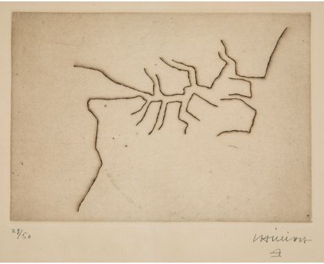
Lot 16
EDUARDO CHILLIDA JUANTEGUI (San Sebastian, 1924 - 2002)."Articulation".Etching on Rives BFK paper. Copy 28/50.Work reproduced in OPUS Volume I, page 52, Nº 62001.Signed and justified in pencil.Measurements: 15.5 x 20.7 cm (print); 38 x 48 cm (paper); 39 x 49 cm (frame).The idea of articulation was a constant in the work of Chillida, who reflected the concept through painting and sculpture. In this particular case, the work on paper shows us a set of vibrant lines that seem to simulate a map in which the spectator can lose himself by looking through the lines.Chillida began his training at the School of Architecture at the University of Madrid, but abandoned his studies to devote himself to football, as goalkeeper for Real Sociedad. As a result of an injury he was forced to give up sport, and it was then that his artistic vocation awoke. He began drawing at the Círculo de Bellas Artes in Madrid, and little by little his interest in sculpture grew. It was during his years in Paris that he made his first plaster sculptures, impressed by the archaic Greek sculpture in the Louvre. He held his first sculpture exhibition in the French capital in 1950. It was at this time that he began his rivalry with the sculptor Jorge Oteiza, who accused him of plagiarising his work. Both with a work linked to the constructivist tradition, they nevertheless dealt with different themes. In 1951 he returned to San Sebastián for good, and produced his first work in iron, the material he would work with for the rest of his life. With the idea that art should be accessible to everyone, he produced numerous public works throughout his life, as well as sculptures for museums all over the world. His works dialogue with their surroundings, which is why many of them are already considered emblematic places for citizens, as is the case with the "Peine del viento" in San Sebastian and the "Puerta de la Libertad" in Barcelona. Throughout his life, Chillida received numerous prizes and awards, including the Carnegie Prize (1965), the Rembrandt Prize (1975), the Wolf Foundation Prize for the Arts (1984/85) and the Prince of Asturias Prize for the Arts (1987). He was also a member of the Royal Academy of Fine Arts of San Fernando, a member of the American Academy of Arts and Sciences, an Honorary Member of the Royal Academy of Arts in London, a member of the Imperial Order of Japan, and was awarded the Grand Cross for Humanitarian Merit by the Institution of the same name in Barcelona. In addition to his Chillida-Leku Museum in Hernani, he is represented in museums and collections all over the world, such as the Guggenheim in Bilbao, the MOMA in New York, the Reina Sofía in Madrid, the Tate Gallery in London and the Neue Nationalgalerie in Berlin.


Lot 144
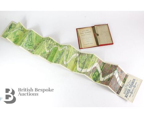
Bird's Eye View of the Thames London to Oxford - In three sections plus accompanying 46 page booklet. Each section has 14 panel linen fold-out maps in lovely, clean condition, very attractive. In worn red gilt covers, no date but on the last map Tower Bridge is captioned as 'constructing', building work completed circa 1886-94 so maps are circa 1890.


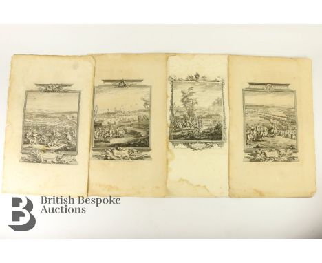
Lot 154
Tindall Nicolas Rev - History of England pages and maps, 18th century, including Map of the Seat of War in Hungary between the Imperialists and the Turks; Map of the Seat of War in Germany; Map of the Seat of War in Italy. The lot continues with maps of cities, battle sites including Plan of Mons; Plan of the Camp & Retrenchments of Denain; Camp of the Army of the Allies Commander by General Auverquerque; Arras the Capital Town of the County of Artois; Plan of Oudenard a Fortified Town in the Earldom of Flanders; Plan of Dunkirk as given to the Duke of Ormond when he left the Army of Allies 1712; Plan of Lisle besieged and taken by the Allies in 1708; Plan of the Battle fought near Winendael; Plan of the City and Citadel of Turin; Lines of Stolhoffen in Alsacia; Battle of Donawert July 1704; Plan of Temiswar and it's Neighbourhood; Plan of Bethune Artois; Plan of Tournay 1709; Plan of the Battle of Eckeren 1703; Plan of Ausburg & Adjacent Country; Old and New Brisach; Plan of the Town of Barcelona; Plan of the Town and Castle of Traarbach; Plan of the Battle of Marseille; Plan of the Town of Menin; Plan of Ypres; Plan of Philipsbourg; Plan of the Town of Bouchain; Plan of the Battle of Chiari; Plan of the Battle of Quesnoy; Plan and Attack of the Town of St Leeuw. Lastly this lot contains title pages including 'The Passage of Scbeld', 'Duke of Marlborough and Prince Eugene of Savoy entering ye enemys intrenchments at the Battle of Taniers; Siege of Mons and The Battle of Luzzara.

-
108737 item(s)/page