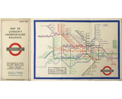
We found 109182 price guide item(s) matching your search

Refine your search

Year

Filter by Price Range
  • List
  • Grid
  • 109182 item(s)
    /page

Lot 372

1946 London Underground quad-royal POSTER MAP by H C Beck (whose names appears on the River Thames!) with a decorative border by 'Shep' (Charles Shepard). Largely in pre-war style, headed 'London's Underground', with the pre-war planned Central & Northern Line extensions to Ongar, West Ruislip, Bushey Heath and Alexandra Palace shown. Folded, with some edge-scuffs and a very small fold-corner parting but generally very good. [1]

Lot 57

c1928/29 London Underground 'Stingemore' POCKET MAP (yellow cover), lightly-used condition, plus 6 other Underground POCKET MAPS dated between 1947-63 and in lightly to heavily-used condition. [7]

Lot 391

1933 first edition of the H C Beck London Underground POCKET DIAGRAMMATIC CARD MAP with the now famous cover slogan "A new design for an old map." This is the version over-printed on the cover with the name of the new London Passenger Transport Board which took over in July 1933. A very good example, just lightly-used. [1]

Lot 224

A selection of military epaulette's, Hat & map holder

Lot 1003

Two boxes of miscellaneous books incl. Stanford's Map of the British Metropolis and Suburbs, 1877, folding, on linen, original boards; Barclay's Dictionary, 1799, 8vo; an In Memoriam album of engravings of Lake District Scenery c.1880; Gordon's [folding] Map of the Derby & Nottinghamshire Coalfields, 1925

Lot 1084

A hand coloured map by John Speede together with another hand coloured map of Holy Island etc

Lot 12

A late 17th Century Robert Morden map of The East Riding of Yorkshire, framed

Lot 39

Foxhound Hunts of Great Britain including kennels (Hampton Court Series), a colour map, framed

Lot 41

A map of Derbyshire, framed

Lot 706

A framed early 19th Century indenture of a property in Nottingham and a 17th Century road map, Nottingham to Lincoln

Lot 111

A cold cast bronze relief map of The Lake District mounted and framed by David Fallows circa 1970s, image size 58 cm x 74 cm. Estimate £30 - £50

Lot 973

A large printed map of China and its provinces, ca. 1880 Dim.: 142 x 99 cm Condition reports and high resolution pictures are available on our website at www.rm-auctions.com. Further questions are always welcome at info@rm-auctions.com

Lot 971

A large printed map of Beijing, China, ca. 1880 Dim.: 60,5 x 57,5 cm Condition reports and high resolution pictures are available on our website at www.rm-auctions.com. Further questions are always welcome at info@rm-auctions.com

Lot 181

A large printed map of Japan and its islands, Meiji, ca. 1900 Dim.: 164 x 158 cm Condition reports and high resolution pictures are available on our website at www.rm-auctions.com. Further questions are always welcome at info@rm-auctions.com

Lot 102

Assassins Creed Revelations Ezio Figurine, highly detailed and XBOX White Edition Assassins Creed II Ezio Figurine (missing playable map) both in mint boxed condition (2 items)

Lot 367

Wooden Painted Railway destination sign Lee-Sidcup-Dartford-Greenhithe-Norfleet-Gravesend, 60cms x 52cms, 3 x Bus/Train advert frames approx 68 cms x 28cms and a 1971 re issue framed Cheffins Map of the English & Scotch Railways 1845, all in fair condition (5 items)

Lot 212

Dr Shuntaro Hida WW2 eyewitness to the dropping of the Hiroshima Atomic bomb signed colour postcard of the mushroom cloud, map of island and his portrait. Good Condition. All signed items come with our certificate of authenticity. We combine postage on multiple winning lots and can ship worldwide. UK postage from £3.95, EU from £4.95, Overseas from £6.95.

Lot 141

A 17th Century Coloured Map by J. Blaeu of Dorset, 38 x 50 cms

Lot 142

A Late 17th or early 18th Century Coloured Map by Saxon/Kip Devonshire, 30 x 35 cms

Lot 143

A 17th Century Coloured Map 'The Road from London' by John Ogilby, 35 x 47 cms

Lot 144

A 17th Century Coloured Map of Dorsetshire by Robert Morden, 38 x 42 cms

Lot 145

A 17th Century Coloured Map of Surrey and Sussex by M Drayton, 26 x 34 cms

Lot 147

An 18th Century Coloured Map of Norfolk by John Cary, 22 x 27 cms, together with another 18th Century coloured map of Norfolk by Thomas Kitchin, 17 x 22 cms

Lot 148

A Small 18th Century Coloured Map of Suffolk together with two other similar maps

Lot 149

A 16th Century Map of Great Britain Ptolemy C Venice, dated 1599 published by Ruscelli-Rosaccio, 25 x 33 cms

Lot 153

An Early Coloured Map of Somerset, together with two coloured prints

Lot 124

THE UNIVERSAL POCKET-BOOK; being the Most Comprehensive, Useful, and Compleat BOOK of the Kind, ever yet Publish'd: containing, amongst a great many other Particulars.....', the second edition corrected and enlarged, printed for T. Cooper at the Globe, in Pater-Noster-Row 1740. Folding pull-out map of the world with one tear and UK coloured in ink, folding pull-out map of England & Wales with tears in margin creases, missing pages at end - finishes on page 266 Condition Report:Leather very worn with losses Various inscriptions on endpapers and back of world map with dates 1740, 1886, 1745

Lot 150

THE TRAVELS OF BERTRANDON DE LA BROCQUIERE, Counsellor & First Esquire-Carver to Philippe Le Bon, Duke of Burgandy, To Palestine and his return from Jerusalem overland to France, during the years 1432 & 1433', translated by Thomas Johnes, Esq., At the Hafod Press by James Henderson, 1807, includes folded map

Lot 151

LOCAL GUIDES II' - BOUND IN ONE VOLUME - 'Hardy's Strangers' Guide Through Dublin' (missing title pages), 'Fraser's Guide to Liverpool (includes folding map A/F, and missing title pages), 'Shuttleworth's Guide Book to Ilkley and Vicinity' second edition, 'A Pictorial Guide to Birmingham' 1849 (includes folding map A/F)

Lot 166

MORDEN - A FRAMED COLOURED MAP 'THE WEST RIDING OF YORKSHIRE'. 47cm x 42cm (including frame)

Lot 1521

A LARGE MAP READING CIRCULAR MAGNIFYING LENS. 6ins diameter.

Lot 267

John Speed, A map of Tartary titled 'A newe mape of Tartary', 1627, 38 x 50cm

Lot 431

"Studies of the Warburg Institute Vol 25 - The St Albans Psalter (Albani Psalter)" University of London, 1960; The Viatores "Roman Roads in the South-East Midlands" Victor Gollancz, London 1964; Hine, Reginald L. "The History of Hitchin Vol. II" and "Hitchin Worthies - Four Centuries of English Life"; "The History of the University of Oxford Vol VII", Clarendon 2000; Partridge, Eric: "A Dictionary of Slang and Unconventional English" volume II of the 6th edition 1967; Burke, Thomas "The English Inn" Edwards-Rees, Désirée "A Rural Youth Service" etc. (in all 23 volumes and also a Carte Taride map of Northern Italy and two small framed and glazed prints)

Lot 403

Butler, Major John "Travels and Adventures in the Province of Assam during a Residence of Fourteen years" Smith, Elder and Co., Cornhill, Bombay: Smith Taylor and Co. 1855 Frontis, folding map, six plates including folding map of the Hill Fort Konomah, hinges cracked, large folding map with tears but no loss, pen inscription on ffep, contemporary marbled boards, half leather but very worn and loss to backstrip

Lot 3372

A collection of five 18th century maps, copper engravings on laid/chain-lined paper, hand colured to include Warwickshire (Kitchin) Ogilby road map of York to West Chester (showing Derby, Buxton): Leicestershire (Robert Morden): Staffordshire (Roabert Morden): and another similar showing Warwickshire (inc. Coventry and Tamworth) framed and glazed (5)

Lot 1009

Trains/Railways Interest: 'Laurie's Travelling Map of England and Scotland, with the Distances Affixed between Town and Town, likewise all the Railways & Stations', engraved fold-out map, backed with linen, sectionalized, original hand-colouring, published by J. Lingard, 3, Ave Maria Lane, 1843. Complete with original Victorian slipcase bearing label. Clean and bright for age, intact, in good order, slipcase has a little wear. A nice 19th-century railway map. The map measures approx. 110cm x 93cm when unfolded.

Lot 1019

Cambden's 'Oxfordshire' 18th Century half leather binding, with marble boards, containing fold out map of Oxfordshire by J Wallis, 1812, and fold out map of Oxfordshire by Robert Morden (undated but laid paper) interestingly bound with blank leaves for notes; together with a separate larger map of Oxfordshire by J. Cary, 1805

Lot 1171

Firestone tyres enamel sign 1950s/60s, depicting map of England and Wales, aurtomobilia advertising interest, approx 121 73cms

Lot 1225

Ten boxed jigsaws, a Hornby zero 1 RG50 Master Control unit (boxed) and two Derby Archaeological Society productions-1852 map of Derby and 1791 Burdetts Derby (4)

Lot 400

CND Ephemera: The Effect of One Hydrogen Bomb .....Exploded on the Free Trade Hall, Manchester, folding map, 19" x 14.5", and other items including draft notes for speakers, Date 1950's

Lot 40

MARTIN M. A Description of the Western Islands of Scotland. Fldg. eng. map (repairs). Calf, rebacked. 1703.

Lot 29

MAURICE WILLIAM & MAGNUSSON EIRIKR (Eds). Heimskringla. 6 vols. in four. Map in pocket. Orig. qtr. morocco gilt. Quaritch, 1893; also one other vol. (5).

Lot 75

CHENIER M. The Present State of the Empire of Morocco. Fldg. map. Orig. cloth. 1967 facsimile reprint of the 1788 ed.; also Cornwallis, Asir Before World War I, pict. brds., 1976 reprint of the Arab Bureau Edition of 1916. (2).

Lot 77

LE MAIR ALBERT. Ecole Militaire, Belgium. Épures. 42 immaculate technical drawing exercises & a double page coloured map. Folio. Qtr. green morocco with title label. 1876.

Lot 774

A quantity of Lincoln & Grantham history books including Phillimore Doomsday books & a print of Lincoln Christs hospital school & framed & glazed Lincolnshire map

Lot 274

LOUIS GABRICE DU BOURG A Bacchanale, etching, 17.5 x 24.5cm; another similar; two after Watteau and an engraved map - 'Tavola Generale Della Provincia Di Sabina', all unframed (5)

Lot 491

SONNINI, C.S. Travels in Upper and Lower Egypt. Trans. Henry Hunter. Stockale, 1899. In 3 volumes. 8vo. Frontis. Port. Folding map in vol. 1 engrd. Plts. Glt. Speckled cf. Tog.with other bindings. 9

Lot 525

KENT, NATHANIEL, General View of the Agriculture of the County of Norfolk, Norfolk Press, 1796, 8vo folding frontis map, 2 plates 1 folding 1/4 cl bds. JOHNSTONE, J, An Account of the Mode of Draining Land, McMillan 1801 2nd ed 8vo 19 folding pl bds

Lot 555

PEARMAN, Rev M,T, A History of the Manor of Bensington,(Benson, Oxon), Elliot Stock 1896. 8vo pull out map cloth bds.

Lot 489

Sark ( Channel Islands) 1958 Tourist’s brochure, history, map, hotels and prices etc…

Lot 1317

An 18th Century map of Cornwall, hand tinted, 46cm x 36cm

Lot 251

A Late Victorian hand painted wall mirror, decorated with swan on a lake, velvet mount, framed; an Egyptian style cut felt wall hanging; another similar hand stitched wall hanging; a map of Wirksworth and surrounding areas (4)

Lot 109

A mid 18th century plan, coloured engravings, for the Langborn Ward and Candlewick Ward, London, with their divisions into Parishes according to a new survey inscribed to Sir Joseph Hankey and to Sir Charles Asgil, Knight, later framed and an 19th century map of the Parish of St Martin's in the Fields, framed

Lot 261

Official railway map of south Wales dated 1898 framed and glazed

Lot 414

Old family bible and Boer War map and reports from the Times dated 13th February 1900 in a faux green leather folio

Lot 577

Rowe (R) Shropshire, engraving, 46 x 36cm (SH) together with a map of Shropshire bu S.Hall, a plan of the Ellesmere Canal by I Muslow, a map of Shropshire by J.Archer, a map of Shropshire by R.Ramble and a map of the stagecoach routes in Shropshire and the surrounding counties by laurie and Whittle, all unframed, various sizes (6)

Lot 584

Bacon's New Survey Map of Staffordshire and Shropshire, laid on linen, 114 x 90cm (SH)

Lot 585

Speed (John) Map of Montgomeryshire, published by John Sudbury and George Humbell 1610, engraving, text verso, 39 x 52cm (PL)

Lot 706

THOROTON (ROBERT) THE ANTIQUITIES OF NOTTINGHAMSHIRE map and plates, lacks imprimatur leaf, calf gilt partly tooled in blind, rebacked, aeg, 1677

Lot 692

MICALI (GIUSEPPE) ANTICHI MONUMENTI PER SERVIRE ALL'OPERA INTITOLATA L'ITALIA AVANTI IL DOMINIO DEI ROMANI folio, engravings, folding map, original vellum covered boards gilt, marbled endpapers, Florence 1821

Loading...Loading...
  • 109182 item(s)
    /page

Recently Viewed Lots