We found 109182 price guide item(s) matching your search
There are 109182 lots that match your search criteria. Subscribe now to get instant access to the full price guide service.
Click here to subscribe- List
- Grid
-
109182 item(s)/page


Lot 1063
An original retro vintage 1960s (1965) Georg Westermann made German school / education wall hanging map of Mittelamerika Und Sudamerika (America). The canvas map mounted on wooden batons top and bottom and rolls out to reveal a full colour map of the USA. Maker's marks to base and stamped date for 1965. Measures approx; 265cm wide.


Lot 7048
Mostyn John Armstrong: 'History & Antiquities of the County of Norfolk', Norwich, 1781, 10 volumes, volume 1 (Blofield, Brothercross & Clackclose), engraved folding map of Norfolk, hand coloured in outline; Volume 2 (Clavering, Depwade, Diss & Earsham), 4 engraved plates including Scole Inn sign and Redenhall Church, both folding, Earsham Hall & Tacolneston Hall; Volume 3 (North Erpingham, South Erpingham & Eynsford) 11 engraved plates including Barningham Hall, Cromer, Felbrigg Hall, Wolterton Hall, Heydon Hall, Baconsthorpe Hall, Wood Dalling Hall etc; Volume 4 (East Flegg, West Flegg & Forehoe), 5 engraved plates including Yarmouth, Costessey Hall, Wymondham Abbey, Easton Lodge etc, Volume 5 (Freebridge Lynn, Freebridge Marshland & Gallow), engraved folding map of Fens + 7 engraved plates including Castleacre, Castle Rising, Middleton Castle etc; Volume 6 (North Greenhoe, South Greenhoe, Grimeshoe & Guiltcross), 6 plates including Binham Priory, Holkham Hall, Walsingham Priory etc; Volume 7 (Happing, Henstead, Holt, Humbleyard & Loddon), 4 plates including Bixley Hall, Kirby Bedon, Hickling Priory etc; Volume 8 (Launditch, Mitford & Shropham), 7 engraved plates including Ditchingham Hall, Quebec Castle, Letton Hall etc; Volume 9 (Smithdon, Taverham, Tunstead, Walsham & Wayland), 6 engraved plates incl. Bromholm Priory, Beeston Hall, Mount Amelia, Westwick House etc; Volume 10 (Norwich), engraved folding plan of Norwich, backed onto linen, + 6 engraved plates including Prospect of Norwich, Cathedral (folding), Robert Kett, Castle, Bank, etc, uniform contemporary half calf gilt, a couple of volumes with loose top boards, oxblood morocco gilt tile labels to spines, a good uniformly bound set with majority of plates and folding plan of Norwich (10)

Lot 7052
'Kelly's Directory of Norfolk', 7 volumes: 1883, lacks map, original cloth gilt (cloth slightly worn and dulled, generally VGC); 1888, folding map (with tape repairs verso), original cloth gilt, rebacked retaining original backstrip (cloth slightly worn and dulled, generally VGC); 1892, folding map (with 1 small closed tear, else VGC), original cloth gilt (bumped at corners, one or two marks lower board, else generally VGC); 1896, lacks map, original cloth gilt (slightly worn and with some blotchy waterstaining, else sound); 1900, folding map, original cloth gilt, later rebacked; 1904, folding map, original cloth gilt (worn and darkened, else sound); 1908, lacks map, original cloth gilt (worn, spine faded and worn at lower joint, inner joints a bit weak). A good collection including some scarcer 19th Century volumes, good reference for local historians and genealogists (7)
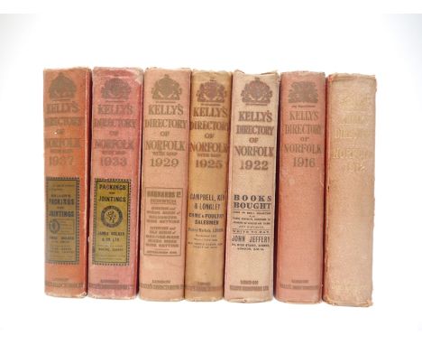
Lot 7053
'Kelly's Directory of Norfolk', 7 volumes: 1912, lacks map, original cloth gilt (worn and faded); 1916, folding coloured map, original printed invoice loosely inserted, original cloth gilt (slightly worn and with mildew marks, inner joints weak); 1922, folding coloured map (with 1 fairly large closed tear), original cloth gilt (bumped, spine faded, inner joints a bit weak); 1925, folding coloured map (tape repairs verso), original cloth gilt (slightly worn/faded, first leaf of adverts part excised); 1929, folding coloured map, original cloth gilt (faded, inner joints slightly weak, else gen. VGC); 1933, folding coloured map, original cloth gilt (slightly worn and discoloured at head of top board/spine, else gen. sound/VGC); 1937, lacks map, original cloth gilt (inner joints weak else gen. VGC). Good reference for local historians and genealogists (7)
Lot 7055
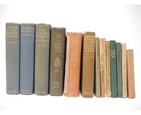
William Alfred Dutt, collection 16 titles, including: 'By Sea Marge, Marsh and Mere', London, Simpkin, Marshall, Hamilton, Kent & Co, Lowestoft, W Gwyn [1898], 1st edition, original printed wraps, plus another copy of the same work, later rebound cloth gilt; 'Highways, Byways and Waterways of East Anglia', Lowestoft & London, 1899, 1st edition, frontis, 168pp, original wraps (toned and slightly worn); 'George Borrow in East Anglia', David Nutt, 1896, 1st edition, original printed wraps; 'King's Lynn (Norfolk), With Its Surroundings', Lynn & London, 1905, 1st edition, folding plan, plates and illustrations in text, original pictorial wraps worn a/f; 'The Waveney Valley in the Stone Age', 1905, original printed wraps (worn, top wrap detached but present); 'A Popular Guide to Norfolk', [1904], 1st edition, map, 104pp, original pictorial wraps; 'The King's Homeland Sandringham & North-West Norfolk', 1904, plates, original cloth gilt; 'Wildlife in East Anglia', 1906, 1st edition, original cloth gilt (VGC); 'Some Literary Associations of East Anglia', 1907, 1st edition, original cloth gilt (VGC); 'A Guide to the Norfolk Broads', 1923, original cloth gilt; plus 5 others (16)
Lot 7058
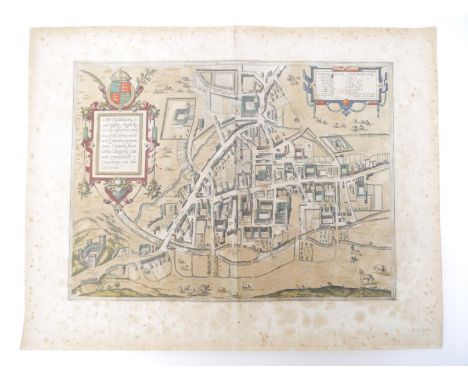
A 16th Century town plan of Cambridge, by Georg Braun & Frans Hogenberg, 'Cantebrigia, opulentissimi Anglie Regni, urbs celeberrimi nominis, ab Academie conditore Cantabro, cognominata...', engraved hand coloured town plan, [1575 or later], degrees of toning/foxing, approx size 33 x 44.5cm, (with margins 44 x 56.5cm), unframed/unmounted, latin text verso. The earliest printed map of Cambridge, published in the 'Civitates Orbis Terrarum', the first series of printed town plans.

Lot 7060
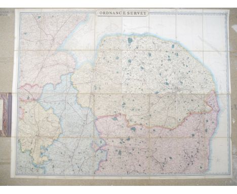
'Cruchley's Reduced Ordnance Map of England & Wales', large engraved hand coloured folding map depicting Norfolk, Suffolk, Cambridgeshire, parts of Lincs., Huntingdonshire, Bedfordshire etc, circa mid 19th Century, titled 'From the Ordnance Survey - No.40', sheets 33, 34, 39 & 40 together as one map and dissected and backed onto linen, approx 100 x 130cm, folding into original cloth binding; together with an Ordnance Survey folding map of Bungay, Harleston & Diss, circa 1912, sheet 77 large sheet series, approx 52 x 72cm (2)
![John Speed: 'Suffolk described and divided into hundreds [Suffolk]', engraved map, London, George Humble Popes-head alley, ci](https://cdn.globalauctionplatform.com/db92bc8e-909d-46a5-84b8-ad320108d7a6/fd0f3275-3dd1-4ecc-bba2-ad3601167daf/468x382.jpg)

![Richard Blome: 'A Mapp of the County of Norfolck with its Hundreds [Norfolk]', engraved hand coloured map, 1673, printed area](https://cdn.globalauctionplatform.com/db92bc8e-909d-46a5-84b8-ad320108d7a6/75aa1a7c-05d5-4bf4-a36c-ad36011798ab/468x382.jpg)

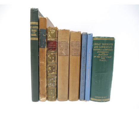
Lot 7066
John Greaves Nall: 'Great Yarmouth and Lowestoft, A Handbook for Visitors and Residents, Chapters on the Topography, Fisheries and Dialect of the East Coast', 1866, 1st edition, 2 volumes in 1, folding plan of Yarmouth + folding map of east coast (neat tear along fold but complete), original cloth gilt, joints weak; 'Walter White: 'Eastern England, from the Thames to the Humber', Chapman & Hall, 1865, 1st edition, 2 volumes, ex lib, old quarter cloth, printed paper labels to spines; Stacy-Watson: 'The Silvery Hosts of the North Sea. With a sketch of Quaint Old Yarmouth', circa 1884, frontis + 10 illustrations, some full page, as called for, original pictorial cloth; Wynne: 'St. Olaves Priory & Bridge, Herringfleet, Suffolk', 1914, original cloth gilt; 'The Suffolk Garland', Ipswich, 1818, 404pp, old half calf gilt; James Bird: 'Framlingham, A Narrative of the Castle, in Four Cantos', London, 1831, engraved frontis of Framlingham Castle, 181pp, old cloth (worn); plus Lowestoft National Union of Teachers Conference Souvenir, 1914, illustrations, original cloth gilt (8)
![[Charles Parkin]: 'The History of Great Yarmouth Collected from Antient Records and other Authentic Materials', Lynn, Whittin](https://cdn.globalauctionplatform.com/db92bc8e-909d-46a5-84b8-ad320108d7a6/994b750c-f471-495b-8a4b-ad320111c7e8/468x382.jpg)
Lot 7069
[Charles Parkin]: 'The History of Great Yarmouth Collected from Antient Records and other Authentic Materials', Lynn, Whittingham et al, 1776, engraved folding view of Yarmouth as called for, old calf, later rebacked calf gilt retaining title label; plus Henry Manship: 'The History of Great Yarmouth', edited Charles John Palmer, Great Yarmouth, Louis Alfred Meall, 1854, 1st edition, coloured frontis, hand coloured folding map + 9 plates (some tinted), as called for, 4to, contemporary quarter calf, original calf gilt spine label; plus John Henry Druery: 'Historical and topographical notices of Great Yarmouth, in Norfolk, and its environs : including the parishes and hamlets of the half hundred of Lothingland, in Suffolk', London, 1826, 1st edition, 8 engraved plates + 2 folding pedigrees + vignette in text as called for, rebound (not recent), quarter calf gilt; plus John Preston: 'The Picture of Yarmouth', Yarmouth, C. Sloman for the author, 1819, 1st edition, large folding engraved plan of Yarmouth, folding table, lacking all other engraved plates, old half green morocco gilt (slightly worn); plus 'Chronicles of the Old Congregational Church at Great Yarmouth 1642 to 1858', Great Yarmouth, 1906, "Printed for Private Distribution Only", 74pp, original cloth gilt; plus one other similar (6)
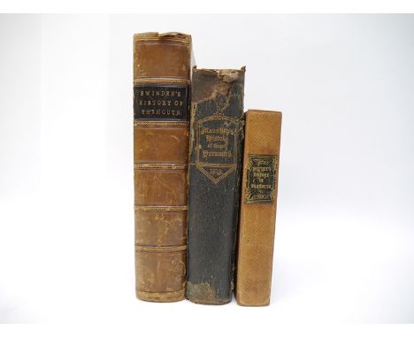
Lot 7070
John Henry Druery: 'Historical and topographical notices of Great Yarmouth, in Norfolk, and its environs : including the parishes and hamlets of the half hundered of Lothingland, in Suffolk', London, 1826, 1st edition, mounted 19th Century portrait photograph of the author and signed and inscribed piece affixed to leaf facing half title, 8 engraved plates + 2 folding pedigrees + vignette in text as called for, grangerized copy with 6 extra illustrations, all tipped in Rock & Co engraved views of Yarmouth, contemporary quarter cloth gilt, rebacked retaining original backstrip and calf gilt tile label; plus Henry Swinden: ''The History and Antiquities of The Ancient Burgh of Great Yarmouth in the County of Norfolk. Collected from the Corporation Charters, Records, and Evidences; and other the most authentic Materials.', Norwich, John Crouse, 1772, 1st edition, large folding plan of Breydon Water, hand coloured in outline and backed onto linen, between pp.412/413, [16],957pp, 4to, old half calf gilt, marbled paper covered boards; plus Henry Manship: 'The History of Great Yarmouth', edited Charles John Palmer, Great Yarmouth, Louis Alfred Meall, 1854, 1st edition, coloured frontis, hand coloured folding map + 9 plates (some tinted), as called for, 4to, contemporary quarter calf gilt, backstrip worn (3)
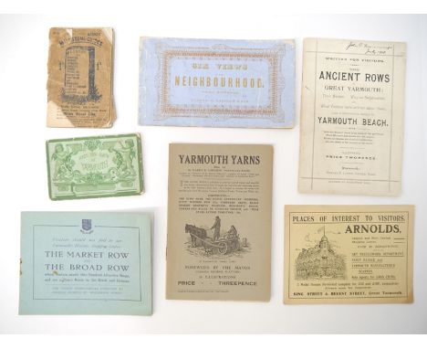
Lot 7080
Eight scarce Great Yarmouth ephemeral pamphlets, booklets, albums etc, comprising Edward John Lupson: 'The Ancient Rows of Great Yarmouth : Their Names, Why so Constructed, and What Visitors have written about them, also a descriptive sketch of Yarmouth Beach.', Yarmouth, Edward J. Lupson, [1897], 33,[6]pp, 12 engraved illustrations of which one double page depicting beach from Britannia pier, original printed wraps; The Market & Broads Rows Traders Association (published): 'Visitors should not fail to see Yarmouth's Historic Shopping Centre: 'The Market Row and The Broad Row whcih contain nearly One Hundred Attractive Shops, and are a Direct Route to the Beach and Stations.', circa 1923, [12]pp, map + 7 black & white ills. from Yallop photographs, original stapled printed wraps (wraps detached from leaves but present); Harry B. Johnson: 'Yarmouth Yarns (No.1)', Great Yarmouth, Jarrold, circa 1920, [12]pp, illustrations in text, original printed wraps; [Frederick Danby Palmer]: 'The Tolhouse, Great Yarmouth', Gt. Yarmouth : John Buckle, printer [nd], 24pp, original stapled pictorial printed wraps; Kershaw & Son (pub.): 'Six Views in This Neighbourhood.', view album, circa 1860's, 6 engraved views of Yarmouth and Lowestoft, oblong, original stitched printed wraps (10.5 x 18.5cm); 'Bond's New Album of Yarmouth', circa late 19th Century view album, 10 views on 12 folding concertina leaves, original printed wraps (7 x 11cm); plus 2 others similar (8)
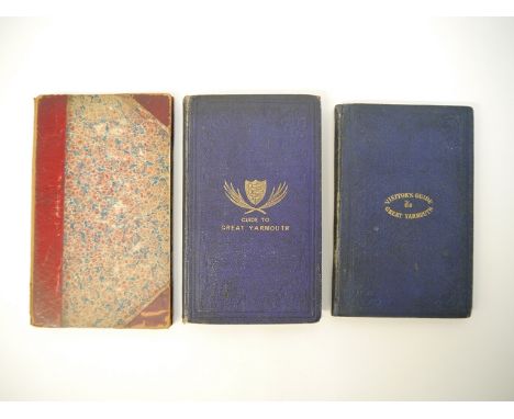
Lot 7084
Three scarce 19th Century Great Yarmouth visitor guidebooks: 'The Visitor's Guide, to The Town and Neighbourhood of Great Yarmouth.', Great Yarmouth, John Cooper, 1853, first edition, engraved folding map + 6 engraved plates as called for, 103pp, original cloth gilt, EP's replenished; plus an 1856 second edition of the same guidebook, published John Cooper, without maps/plates, 86pp + ad. leaf at end, old half calf gilt; plus 'Pictorial Guide to Great Yarmouth', Yarmouth, George Nall, 1864, 10th edition revised and enlarged, folding map + 30 illustrations (of which 25 full page), 158pp, original blindstamped cloth gilt (3)

Lot 7086
Seven various Great Yarmouth guidebooks, including: 'the Guide to Great Yarmouth', G.Y., Cobb, circa 1860, 9th edition revised and enlarged, folding plan + 29 ills., of which several full page, as per list, 128pp + [16]pp ads. at end, original cloth; 'Nall's Shilling Yarmouth Guide', 1884,15th edition, folding map, folding plan + ills. in text as called for, original printed card wraps, but partially stuck to old brown paper covering; plus a Jarrolds' Illustrated Guide to Great Yarmouth, by Lemmon Lingwood, circa 1900, folding maps and ills., original cloth; plus 2 Ward Lock Red Guides circa early 20th Century, A 'Pearson's Gossipy Guide to Great Yarmouth...', circa 1900 (cloth soiled), plus 1 other (7)
Lot 7095
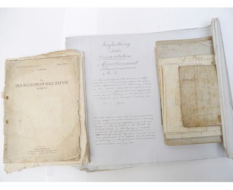
A quantity of mainly local interest items, including St Mary's Church Hinderclay, Report from Architect on the State of the Tower, 1886, 6 page m/s report by John Goldicutt Turner, F.R.I.B.A., signed by him at end, with m/s covers by him, a/f, waterstaining throughout and cover with tear/part loss; a roll of 30+ 19th Century Winfarthing manuscript tithe documents, commutation apportionment showing how rentcharge for district apportioned to individual landowners and tithe to be paid for each plot of land; sale particulars including 1853 freehold and copyhold estates in Forncett St Peter & Tacolneston, late the property of Wm. Blomfield, folding map, [4]pp, original wraps, plus others Thompson & Griston; Old Buckenham Estate 1921; Old Buckenham Hall Estate 1932, these a/f; Hockham Hall Estate 1930; Freehold properties, Barford, 1921; small quantity 18th & 19th Century vellum deeds including Ipswich (2), Norwich etc; Norwich Union card calendars 1913 & 1914, plus a similar Alliance Assurance example
Lot 7097A
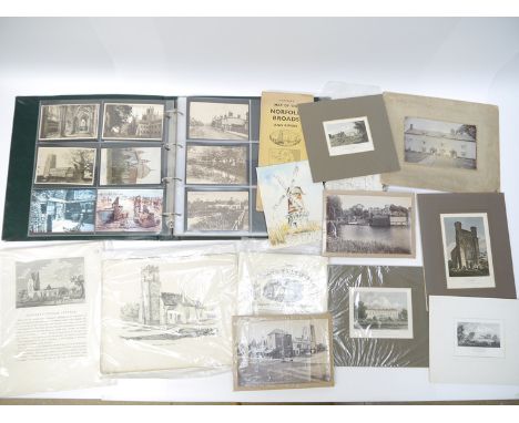
A quantity of East Anglia related postcards, ephemera, prints, etc., including two late 19th Century albumen print photographs of Beccles by James Valentine, comprising view 27465 depicting Market Place, and view 27469 depicting River Waveney with church visible on far bank of river, each loose approx. 13.5cm x 20cm; album of postcards including Ely, Soham, Cambridge, Yarmouth, Clacton, etc., plus a quantity of loose postcards Southwold and Walberswick (many duplicates); Ladbrooke stone lithographs Norfolk churches including Ditchingham, framed and glazed, Stoke Holy Cross and Bramerton, mounted; 14 others loose in packet including Broome, Framingham Pigot, Framingham Earl, Tibenham, etc., other framed and glazed 19th Century prints including G. Fitt/Day & Haghe litho of Harleston, Fullarton map of Suffolk, mounted copper engraving of Alderton Church in Suffolk by Noble, circa 1800, etc., etc
![A collection of 15 various East Anglia related titles, including [Richard Beatniffe]: 'The Norfolk Tour', 1808, 6th edition,](https://cdn.globalauctionplatform.com/db92bc8e-909d-46a5-84b8-ad320108d7a6/995ba08b-f369-4b4c-8a54-ad3300bcfb87/468x382.jpg)
Lot 7104
A collection of 15 various East Anglia related titles, including [Richard Beatniffe]: 'The Norfolk Tour', 1808, 6th edition, lacks folding map, rebound half calf gilt, replenished EP's; Henry Harrod: 'Gleanings among the Castles and Convents of Norfolk', Norwich, 1857, ''published by subscription'', numerous plates and charts, some hand coloured/folding, old half green morocco gilt, top edge gilt; J. Ewing Ritchie: 'East Anglia. Personal Recollections and Historical Associations', 1893, 2nd edition revised & enlarged, content includes Dawson Turner, Sarah Martin, Hannah More, Hudson Gurney etc etc, original cloth gilt; Farrer: 'List of Norfolk Monumental Brasses', 1890, 1st edition, original printed paper covered boards, later rebacked; Dukinfield Astley (Ed.): 'Memorials of Old Norfolk', 1908, 1st edition, profusely illstrated throughout, original cloth gilt, top edge gilt; Bayne: 'Royal Illustrated History of Eastern England', [1873], 2 volumes, original cloth gilt; Claude Messent: 'The Old Cottages and Farm-Houses of Norfolk', 1928, 1st edition, plus 3 others by him; plus 4 others (15)
![Samuel William Aldwell, Vicar of Wingfield: 'Wingfield: Its Church, Castle and College', Ipswich, W.E. Harrison, [1925], 1st](https://cdn.globalauctionplatform.com/db92bc8e-909d-46a5-84b8-ad320108d7a6/399d01c7-bd1f-4eb4-89bb-ad3300bd0429/468x382.jpg)
Lot 7114
Samuel William Aldwell, Vicar of Wingfield: 'Wingfield: Its Church, Castle and College', Ipswich, W.E. Harrison, [1925], 1st edition, large folding map + 28 full page illustrations on 26 plates as called for, ills. mainly by J.E. Groom from photographs, family tree of Cornwallis of Wingfield by Stephen Govier tipped in at front, original cloth gilt, bookplate of David Gurling of Lavenham to front pastedown. Scarce
![[Charles Frederick Cory Elvin]: 'An Account of the Oakleys [Suffolk.] With a compiler's vagaries about some inhabitants there](https://cdn.globalauctionplatform.com/db92bc8e-909d-46a5-84b8-ad320108d7a6/43c718e3-bd82-46e5-a637-ad3300bd0849/468x382.jpg)
Lot 7119
[Charles Frederick Cory Elvin]: 'An Account of the Oakleys [Suffolk.] With a compiler's vagaries about some inhabitants there whose names have been found in various records dating from early times', 1942, privately printed subscription copy No.40, signed by Cornwallis in pencil and bookplate of the Earl of Cornwallis of Brome Hall, Suffolk, to front pastedown/FFEP, frontis + map + 8 plates as called for, contemporary plain cloth, notes on the author Charles Frederick Cory Elvin (1883-1961), Vicar of Brome & Oakley, missionary to Japan, by Stephen Govier tipped in at end. Scarce
Lot 7128
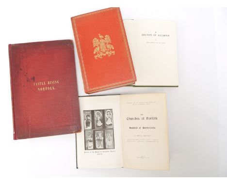
William Taylor: 'The History and Antiquities of Castle Rising, Norfolk', Lynn & London, 1850, engraved frontis + 11 engraved plates as called for (by William Taylor & William Pickford), original cloth gilt, rebacked retaining original backstrip, copy of P.F.H. Bedingfield of Heacham; plus John Sapwell: 'A History of Aylsham', 1960, 1st edition, folding map + 10 plates as called for, original cloth gilt; T. Hugh Bryant: The Churches of Norfolk: hundred of Brothercross', 1914, numerous ills. from photos as called for, covering The Burnhams, North & South Creake and Waterden, North Norfolk, original cloth gilt; 'Coke of Norfolk & His Friends, the Life of...First Earl of Leicester, of Holkham', 1908, vol 2, numerous plates, original cloth gilt (lacks backstrip), top edge gilt (4)

Lot 7169
Five titles on big game hunting and related, comprising Philip H. Percival: 'Hunting, Settling and Remembering', Trophy Room Books, 1997, limited edition (682/1000), numbered and signed by the author's grandson, numerous illustrations from photographs as called for, original leatherette gilt, dust wrapper; Terry Wieland: 'Spiral-Horn Dreams', Trophy Room Books, 1995, limited edition (574/1000), numbered and signed, numerous illustrations from photographs as called for, original leatherette gilt, dust wrapper; A. Radcliffe Dugmore: 'Camera Adventures in the African Wilds. Being an account of a four months' expedition in british east africa, for the purpose of securing photographs from life of the game.', London, Heinemann, 1910, map + numerous illustrations from photos as called for, 4to, original pictorial cloth gilt (backstrip worn and faded), top edge gilt; Calabi, Helsley & Sanger: 'A Grand Tradition, John Rigby & Co.', Dallas, Rigby Press, 2012, 1st edition, eight various signatures to half title page, finely illustrated in colour and b/w from photographs, drawings etc, large 4to, original pictorial boards, dust wrapper; plus 1 other similar (5)

Lot 7172
Theodore A. Cook: 'Rowing at Henley', O.U.P., 1919 1st edition, frontis and two full page illustrations, two illustrations in text, plus folding map of the Henley Course and another folding plate showing diagrams of boat building and cinematograph of a rowing stroke, as called for (the two folding plates in rear pocket often lacking), original cloth gilt, with 20pp booklet by Harcourt G. Gold: 'The Common Sense of Coaching', March 1920, original printed wraps, Marlow Rowing Club contemporary typed sheet of training rules loosely inserted, together with 'The Rowing Almanack and Oarsman's Companion 1923', The Field Press, 261pp and ads at front and end, 16mo, original cloth gilt (3)

Lot 7230
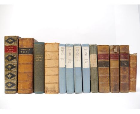
A collection of ancient history, classical civilizations, ancient Egypt, Greece and Rome related works, including Capt. J.W. Watkins: 'Popular History of Egypt', London, James Hagger, [1886], 768,176pp, 29 steel engraved plates as called for, plus strip map of Nile but lacking large folding map of Egypt, old half calf, spine gilt in compartments; William Smith: 'A Dictionary of Greek and Roman Antiquities', 1882, 1293pp, old calf gilt (worn); Edward Gibbon: 'The History of the Decline and Fall of the Roman Empire', Jones & Co, 1826-1828, 12 volumes in 4, 4 added engraved title pages, engraved portrait + 3 folding engraved maps, uniform 20th Century paper covered boards, typed labels to spines; Philip Smith: 'An Ancient History, from the Earliest Records to the Fall of the Western Empire', 1868, 3 volumes, 21 maps and plans (some folding) as called for, uniform contemporary half calf gilt (worn); plus 'Works of Flavius Josephus', translated W. Whiston, 1846 Virtue edition, old half calf, plus an 1850 Halifax published edition, original cloth, rebacked retaining original backstrip; plus 2 others (13)

Lot 7274
Henry Williamson and related, 6 limited edition titles, mainly signed, comprising: 'The Labouring Life', Cape, 1932, limited edition of 122 copies, of which 118 for sale, this copy signed and numbered 20, photogravure frontis, map end papers, original quarter vellum gilt, original acetate dust wrapper with paper inside flaps, top edge gilt, others uncut; 'The Village Book', Cape, 1930, limited edition (361/504), signed and numbered, photogravure frontis, original quarter vellum gilt, top edge gilt, others uncut; 'The Ackymals', Windsor Press, 1929, limited edition (164/225), signed verso title page and numbered, original cloth backed decorative paper covered boards, slipcase (worn); Herbert Faulkner West: 'The Dreamer of Devon, An Essay on Henry Williamson', Ulysses Press, 1932, limited edition, one of 250 copies, signed and inscribed by author to FFEP, original quarter cloth; 'The Scandaroon', ill. Ken Lilly, 1972, limited edition (51/250), numbered and signed, original pictorial leather gilt, all edges gilt, slipcase; 'The Mistress of Vision by Francis Thompson', 1966, limited edition (226/500), "Now Reprinted with...an essay on Francis Thompson by Henry Williamson", original cloth gilt, glassine dust wrapper (6)
Lot 7001
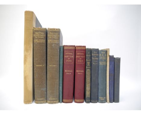
Small collection India, British Raj, Hinduism, Philosophy etc, comprising 'Imperial Gazetteer of India. Provincial Series - Bengal', Calcutta, Superintendent of Government Printing, 1909, 2 volumes, xxviii,489pp & xxviii,553pp, 2 folding coloured maps of Bengal with Sikkim + 2 folding coloured plans of Calcutta/Environs of Calcutta, uniform original cloth gilt; Marshall: 'A Guide to Sanchi', Delhi, 1936, 2nd impression, 2 folding plans + 8 plates as called for, original cloth gilt; 'Jodhpur', guide book, Jodhpur Government Press, 1938, 2nd edition, folding map, plates, folding pedigree as called for, original cloth; B.R. Ambekdar: 'Annihilation of Caste, with a reply to Mahatma Gandhi', Bombay, 1945, 3rd edition, xiv,81,28pp, original printed wraps; 'British Government in India', Cassell, 1925, 1st edition, 2 volumes; Waddington: 'Indian India as seen by a guest in Rajasthan', Jarrolds, 1933, 1st edition; plus 4 others similar (12)

Lot 7002
Henry Noel Shore: 'The Flight of the 'Lapwing' a Naval Officer's Jottings in China, Formosa & Japan', London, Longmans, 1881, 1st edition, frontis + full page illustration + 2 maps (1 folding) as called for, contemporary blue calf gilt, spine gilt in compartments, together with A.H.S Lander: 'Tibet & Nepal', A & C Black, 1905, map + 75 coloured plates as called for, original decorative cloth gilt, rebacked retaining original backstrip, plus one other (3)

Lot 7003
Colonel Henry Yule: 'The Book of Ser Marco Polo, The Venetian, Concerning the Kingdoms and Marvels of the East', London, John Murray, 1871, 2 volumes, folding maps, plans, facsimiles, plates as called for, original cloth gilt; Major Clarence Dalrymple Bruce: 'In the Footsteps of Marco Polo. Being the Account of a Journey Overland from Simla to Pekin', Edinburgh, 1907, 1st edition, 40 illustrations, lacks folding map, original cloth gilt (3)

Lot 7005
J.D Barbie Du Bocage, J.J. Barthelemy: 'Recueil de Cartes Geographiques, Plans, Vues et Medailles de L'Ancienne Grece, Relatifs au Voyage du Jeune Anachasis', Paris, Bossange et al, 1807, large engraved folding map of the ancient world, hand coloured in outline, plus 31 engraved maps, plans and plates, many folding and hand coloured in outline, as called for, 32pp text, 4to, contemporary half calf gilt (worn)


Lot 7010
E. George Squier: 'Peru, Incidents of Travel & Exploration in the Land of the Incas', London, Macmillan, 1877, 1st edition, folding map and numerous plates and illustrations collated complete, original pictorial cloth gilt, top edge gilt; Sir C.R. Markham: 'The Incas of Peru', London, Smith, Elder, 1910, 1st edition, large folding map and 12 plates as called for, original cloth gilt, a 1912 pocket edition of Edward Whymper: 'Travels Amongst the Great Andes of the Equator', original cloth gilt; plus Russell: 'The History of Old Durban', Natal, Davis [1899] 1st edition, folding map and four plates as called for, original pict. cloth gilt (very worn, joints near split, some leaves loose at front), plus one other similar, ex libris Arthur Lumsden-Bedingfield (5)
Lot 7013
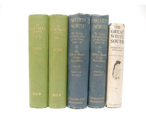
Fridtjof Nansen, 2 titles: 'Farthest North', London, Archibald Constable, 1897, 1st edition, 2 volumes, etched frontispiece to volume 1, photogravure frontispiece to volume 2, 127 plates of which 16 in colour, 92 illustrations to the text, 3 (of 4) folding colour maps, title pages printed in red and black, original pictorial cloth gilt, 'In Northern Mists, Arctic Exploration in Early Times', London, William Heinemann, 1911, 1st edition, 2 volumes, tipped in coloured frontispieces, plus numerous black and white illustrations in text as called for, ex library, rebound library cloth gilt, plus Herbert Ponting: 'The Great White South, or with Scott in the Antarctic', Duckworth, 1935, 11th impression, map + 166 ills., mainly from photos, as called for, original cloth and in the uncommon dust wrapper (slightly worn with some small part losses (5)


![Jan Jansson: 'Cantium Vernacule Kent [Kent]', engraved hand coloured map, circa 1646, latin text verson, approx 38.5 x 49.5cm](https://cdn.globalauctionplatform.com/db92bc8e-909d-46a5-84b8-ad320108d7a6/0412ffe8-120d-4afa-90b4-ad36011762ee/468x382.jpg)
![Johannes Blaeu: 'Huntingdonensis Comitatus [Huntingdonshire]', engraved hand coloured map, circa 1645, decorative title carto](https://cdn.globalauctionplatform.com/db92bc8e-909d-46a5-84b8-ad320108d7a6/6976ef9b-60ff-4a47-b8f1-ad360117663c/468x382.jpg)
![Johannes Blaeu: 'Northantonensis Vernacule [Northamptonshire]', engraved hand coloured map, Amsterdam, circa 1650, approx 41.](https://cdn.globalauctionplatform.com/db92bc8e-909d-46a5-84b8-ad320108d7a6/2f1b5dab-6fec-4842-8e29-ad360117694f/468x382.jpg)
![Johannes Blaeu: 'Comitatus Nottinghamiensis [Nottinghamshire]', engraved hand coloured map, circa 1648, together with an unco](https://cdn.globalauctionplatform.com/db92bc8e-909d-46a5-84b8-ad320108d7a6/291dd050-7c6d-43c0-b850-ad3201119209/468x382.jpg)
![Johannes Blaeu: 'Comitatus Northumbria [Northumberland]', hand coloured engraved map, circa 1645, latin text verso, approx 40](https://cdn.globalauctionplatform.com/db92bc8e-909d-46a5-84b8-ad320108d7a6/7ad599f4-228a-406e-9596-ad3601176c59/468x382.jpg)
![John Speed: 'The Countye Palatine of Chester [Cheshire]', 18th Century engraved hand coloured map, without text verso, inset](https://cdn.globalauctionplatform.com/db92bc8e-909d-46a5-84b8-ad320108d7a6/9af8fed3-bbef-4622-9f34-ad3601176fe0/468x382.jpg)
![Johannes Blaeu: 'Cestria Comitatus Palatinus [Cheshire]', engraved hand coloured map, circa 1645, approx 38.5 x 50.5cm, frame](https://cdn.globalauctionplatform.com/db92bc8e-909d-46a5-84b8-ad320108d7a6/6597b3fe-74bb-41ef-8cae-ad360117738b/468x382.jpg)

![Johannes Blaeu: 'Devonia vulgo Devon-Shire [Devon]', engraved hand coloured map, circa 1645, French text verso, approx 39.5 x](https://cdn.globalauctionplatform.com/db92bc8e-909d-46a5-84b8-ad320108d7a6/d7665846-28ea-4487-8149-ad3601177a59/468x382.jpg)

Lot 7029
John Speed: 'Cornwall', engraved hand coloured map, circa 1611, Sudbury & Humble, inset view of Launceston, ships, sea monsters and heraldic shields, some wear along central fold with tape reinforcement verso, framed and double glazed, English text verso, approx 38 x 50.5cm, the whole approx 51 x 64cm
![Johannes Blaeu: 'Anglia Regnum [England & Wales]', engraved hand coloured map, Amsterdam, circa 1662, decorated with four](https://cdn.globalauctionplatform.com/db92bc8e-909d-46a5-84b8-ad320108d7a6/9d039bf8-5b51-47ca-a55a-ad3601178120/468x382.jpg)
Lot 7030
Johannes Blaeu: 'Anglia Regnum [England & Wales]', engraved hand coloured map, Amsterdam, circa 1662, decorated with four ships, a scale of miles flanked by sheep and a cherub, and two coats of arms of Great Britain and England surmounting the title cartouche, Spanish text verso, framed and double glazed, approx 38.5 x 50cm, whole approx 56 x 68cm

Lot 7032
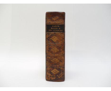
Atlases, England & Wales - John Cary: 'Cary's Travellers's Companion; or, a Delineation of the Turnpike Roads of England and Wales; shewing the immediate Route to every Market and Borough Town throughout the Kingdom', London, G & J Cary, 1826, copper plate engraved title page + 43 engraved maps, all with hand colouring in outline, including folding map of Yorkshire, as called for, bound together with 'Cary's New Itinerary: or, an accurate delineation of the great roads, both direct and cross, throughout England and Wales', 1826, 10th edition, hand coloured large folding map of England & Wales + 6 engraved folding maps, hand coloured in outline, as called for, contemporary calf gilt, rebacked retaining original backstrip, contemporary ownership signature of Viscount Galway, Serlby, Notts., verso FFEP, with some manuscript notes on distances of a journey on page preceding title

Lot 7033
Lengths and Levels to Bradshaw's Maps of the Canals, Navigable Rivers and Railways, in the Principal Parts of England, dedicated to Thomas Telford, 1833, 8vo, pp15 + [1], [bound with] Canals and Navigable Rivers, no separate title, pp5-20, [bound with] lengths and levels to Bradshaw's Maps of Canals, Navigable Rivers from actual survey, dedicated to Thomas Telford, 1832, pp15 + [1], folding engraved map to third part; 'Continuation of the Lea Navigation and River Stort' + 'Continuation of the Grand Junction Canal and the proposed London & Birmingham Rail Way', publisher's paper-covered boards
-
109182 item(s)/page