We found 109182 price guide item(s) matching your search
There are 109182 lots that match your search criteria. Subscribe now to get instant access to the full price guide service.
Click here to subscribe- List
- Grid
-
109182 item(s)/page


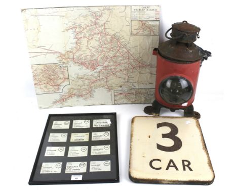
Lot 572
A Denys Fisher Jamie Sommers The Bionic Woman Figure, with Mission Purse containing map case, wallet, make-up case, decoder case, comb, brush, mirror, pretend cosmetics (3), decoder sheet, bionic money and maps (2), in original box with instructions, G, life-like skin on arm hardened and cracked, box F, some tape repair

![[MISCELLANEOUS] Eighteen assorted works, in nineteen volumes, including Mothersole, Jessie. The Isles of Scilly, reprint, Re](https://cdn.globalauctionplatform.com/3313c7d3-7e5f-48ee-8b1f-b0d101040be6/d78f1562-0441-4dd0-b078-b0df00ccc0a0/468x382.jpg)
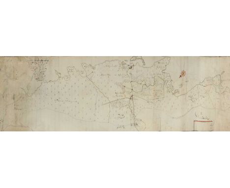
Lot 120
[MISCELLANEOUS] Eighteen assorted works, in nineteen volumes, including Mothersole, Jessie. The Isles of Scilly, reprint, Religious Tract Society, London, 1919, original blue cloth, twenty-six colour plate illustrations (including frontispiece, as called for), map, square octavo; Powell, Commander J.W. Damer. Bristol Privateers and Ships of War, first edition, Arrowsmith, Bristol, 1930, original crimson cloth, plate illustrations, quarto (front free endpaper with hole to centre); and Malet, Captain. Annals of the Road, or Notes on Mail and Stage Coaching in Great Britain, Longmans, Green & Co., London, 1876, original pictorial crimson cloth gilt (rebacked), ten colour plate illustrations (including frontispiece) and three woodcuts (all as called for), octavo.


Lot 38
TRAVEL BOOKS - FRANCE (1/2) COMPRISING: André le Nôtre in Perspective, Patricia Bouchenot-Déchin and Georges Farhat (eds.), Châteaude Versailles, 2013 New Map France, Herbert Ypma, Thames & Hudson, Ltd., London 2020 Royal Treasures from the Louvre, Marc Bascou et al., Fine Art Museum of San Francisco et al., 2012 ETC (20) Condition: For a condition report or further images please email hello@hotlotz.com at least 48 hours prior to the closing date of the auction. This is an auction of preowned and antique items. Many items are of an age or nature which precludes their being in perfect condition and you should expect general wear and tear commensurate with age and use. We strongly advise you to examine items before you bid. Condition reports are provided as a goodwill gesture and are our general assessment of damage and restoration. Whilst care is taken in their drafting, they are for guidance only. We will not be held responsible for oversights concerning damage or restoration.


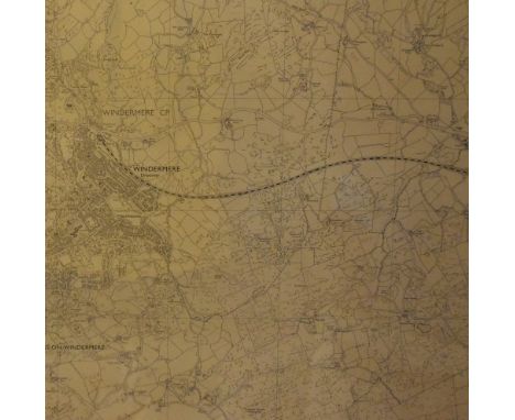
Lot 517
*Local Interest - An Ordnance Survey Map of Cumbria, Sheet SD 49 NW, scale 1:10000, showing Windermere and surrounding area, framed and under glass, measuring 59cm x 69cm overall, & a coloured print, after John Atkinson Grimshaw (1836-1893, British), entitled 'Liverpool Quay By Twilight', also framed and under glass
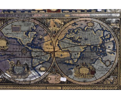
Lot 510
After Sir William Russell Flint RA ROI (1880-1969, British), coloured print, Public Bath, framed, mounted, and under glass, measuring 26cm x 36cm, & 44cm x 54cm overall, together with a double hemisphere mirrored glass print, 'A New & Accurate Map of the World', and two vintage advertising prints for Scotch Whisky and Cocoa (4)

Lot 152
A Cattewater conveyance with original blue wax seal, detailing the sale of land circa 1893 for the price of £25 being the land at price Rock quarry Cattewater, including a small colourful map diagram of the property, "two shillings and six pence" stamp in right hand corner and ornately embellished border, framed, glazed and mounted, overall size 60cm x 80cm. A summary of the document's inscription reads: Albert, "Duke of Saxony, Cornwall and Rothesay , Earl of Chester, Carrick, and Dublin (...) under the authority of the Duchy of Cornwall Management (...) in consideration of the sum of twenty-five pounds by the right honourable Albert Edmund Earl of Morley paid into the bank of England (...) on the twenty ninth day of May in the year of our lord one thousand eight hundred and ninety six."

Lot 49
BARON C. HÜGEL - TRAVELS IN KASHMIR AND THE PANJAB, 1845 London: John Petheram 1845, indistinctly signed and dated 1846, with accompanying map. Condition: Book is in fine condition, minor very occasional toning, ink inscription to title page, the map has a complete split at central fold and is now in two parts. Please see additional photos. This is an auction of preowned and antique items. Many items are of an age or nature which precludes their being in perfect condition and you should expect general wear and tear commensurate with age and use. We strongly advise you to examine items before you bid. Condition reports are provided as a goodwill gesture and are our general assessment of damage and restoration. Whilst care is taken in their drafting, they are for guidance only. We will not be held responsible for oversights concerning damage or restoration.

Lot 121
AN ASSORTED GROUP OF MAPS OF INDIA 18th and 19th century, comprising also a map of Delhi; foxing, toned, tears, creases at borders, folds (7 total) the largest - 60 x 49.5cm Condition: Please see additional photos. This is an auction of preowned and antique items. Many items are of an age or nature which precludes their being in perfect condition and you should expect general wear and tear commensurate with age and use. We strongly advise you to examine items before you bid. Condition reports are provided as a goodwill gesture and are our general assessment of damage and restoration. Whilst care is taken in their drafting, they are for guidance only. We will not be held responsible for oversights concerning damage or restoration.

Lot 76
A LARGE MAP OF INDIA, 1844 Titled lower left "Map of the Peninsula of India, from the 19th Degree of North Latitude, to Cape Comorin." London 1844, in two halves; tear at borders, tapered at back, foxing, needs cleaning 117 x 85.5cm Condition: For a condition report or further images please email hello@hotlotz.com at least 48 hours prior to the closing date of the auction. This is an auction of preowned and antique items. Many items are of an age or nature which precludes their being in perfect condition and you should expect general wear and tear commensurate with age and use. We strongly advise you to examine items before you bid. Condition reports are provided as a goodwill gesture and are our general assessment of damage and restoration. Whilst care is taken in their drafting, they are for guidance only. We will not be held responsible for oversights concerning damage or restoration.

Lot 81
THREE MAPS OF PARIS AND A FRONTISPIECE One map dated 1767, the frontispiece titled "Atlas National Illustré des 86 Départements et des Possessions de la France...", V. Levasseur, published by A. Combette 1852; toning, tears at borders (4 total) the largest - 47.5 x 66cm Condition: For a condition report or further images please email hello@hotlotz.com at least 48 hours prior to the closing date of the auction. This is an auction of preowned and antique items. Many items are of an age or nature which precludes their being in perfect condition and you should expect general wear and tear commensurate with age and use. We strongly advise you to examine items before you bid. Condition reports are provided as a goodwill gesture and are our general assessment of damage and restoration. Whilst care is taken in their drafting, they are for guidance only. We will not be held responsible for oversights concerning damage or restoration.

Lot 48
G. T. VIGNE - TRAVELS IN KASHMIR, LADAK, ISKARDO ETC., 1842 London: Henry Colburn 1842, 2 volumes; map is present, inscribed and dated 'Ashburnham 1842', occasional foxing Condition: Moderate toning to some internal plates, minor toning throughout, map has small split near fold and moderate toning. Please see additional photos. This is an auction of preowned and antique items. Many items are of an age or nature which precludes their being in perfect condition and you should expect general wear and tear commensurate with age and use. We strongly advise you to examine items before you bid. Condition reports are provided as a goodwill gesture and are our general assessment of damage and restoration. Whilst care is taken in their drafting, they are for guidance only. We will not be held responsible for oversights concerning damage or restoration.

Lot 127
A 19TH CENTURY MAP OF THE STRAITS OF SINGAPORE Titled at upper centre "This Survey of the Straits of Singapore, is respectfully inscribed to the Hon.ble Colonel Butterworth C. B. [...]" and presented in a gilt wood frame; foxing 110 x 134 (including frame) Condition: For a condition report or further images please email hello@hotlotz.com at least 48 hours prior to the closing date of the auction. This is an auction of preowned and antique items. Many items are of an age or nature which precludes their being in perfect condition and you should expect general wear and tear commensurate with age and use. We strongly advise you to examine items before you bid. Condition reports are provided as a goodwill gesture and are our general assessment of damage and restoration. Whilst care is taken in their drafting, they are for guidance only. We will not be held responsible for oversights concerning damage or restoration.
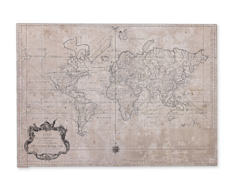
Lot 126
A FRENCH WORLD MAP (1748) Titled at lower left within cartouche "Essay d'une carte réduite contenant les parties connuees du globe terrestre"; folds as issued, border trimmed, some foxing and staining throughout 50.3 x 70.2cm Condition: For a condition report or further images please email hello@hotlotz.com at least 48 hours prior to the closing date of the auction. This is an auction of preowned and antique items. Many items are of an age or nature which precludes their being in perfect condition and you should expect general wear and tear commensurate with age and use. We strongly advise you to examine items before you bid. Condition reports are provided as a goodwill gesture and are our general assessment of damage and restoration. Whilst care is taken in their drafting, they are for guidance only. We will not be held responsible for oversights concerning damage or restoration.

Lot 128
A 1794 MAP OF ITALY Published 12th May 1794 by Laurie & Whittle, London; foxing, needs cleaning, small stains at right border, folded horizontally at centre 67 x 53.5cm Condition: For a condition report or further images please email hello@hotlotz.com at least 48 hours prior to the closing date of the auction. This is an auction of preowned and antique items. Many items are of an age or nature which precludes their being in perfect condition and you should expect general wear and tear commensurate with age and use. We strongly advise you to examine items before you bid. Condition reports are provided as a goodwill gesture and are our general assessment of damage and restoration. Whilst care is taken in their drafting, they are for guidance only. We will not be held responsible for oversights concerning damage or restoration.


Lot 45
"Tri-Tactics", The Great Game of Tactics on Land, Sea and in the Air. British board game Tri-Tactics, by H.P. Gibson & Sons Ltd. The game consists of: A two-part paper-covered cardboard box. The paper has a grey diagonal striped pattern. A label attached to the lid depicts a battle scene below the title of the game. 1 folding mounted map board depicting areas of land and sea. 2 square printed blue cards with a look-up table on one side and text on the other. 56 small blue-backed cards, the front of each depicting a different type of military unit. 56 small red-backed cards, the front of each depicting a different type of military unit. 111 metal card stands. 1 printed staple-bound rules booklet.


Lot 636
A 17th century map of 'Norfolk A Countie Florishing & Populous Described and Divided with the Armes of Such Noble Families as Have Borne the Title Thereof' engraved by J Goddard, hand coloured reverse glazed with index of settlements and description of County - 54cm x 42cm, framed and glazed


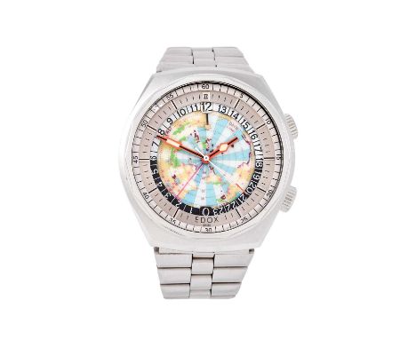
Lot 2421
Edox: A Stainless Steel Automatic GMT World Time Display Wristwatch, signed Edox, model: Geoscope 42, 1970's, lever movement, world map dial display with outer baton markers, inner sliding black/white 24-hour disc, tonneau shaped case with two Edox logo crowns, back cover with Edox logo and numbered 200170, Edox stainless steel bracelet with a deployant clasp42mm wideCase and bracelet with surface scratches, case with minor dents in parts, both crowns with Edox logos, hand setting crown and stem is pulling out into the hand setting position and the hands are moving correctly, but the stem is attached from the case and pulls straight out, stem needs correctly securing, GMT black/white disc with small pieces of the painted surfaces missing in parts, outer 60-minute track slightly discoloured and signs of touch-up paint at the 53 minute position, hands are clean and luminous is complete, hand setting correctly, central world map is moving when hand setting, movement in going order.


Lot 7219
"MAP OF THE EMPIRE OF GERMANY.. by "L. Delarochelle... London 1794" - teilkolorierte, 4 seitige Kupferstichkarte des 18. Jhdt., hinter Glas in massivem Mahagonirahmen mit Messing - Eckrosetten gerahmt. Platte ca. 51,5 x 119,5 cm. Rahmen beigegeben, max. Außenmaß ca. 60 x 125 cm. Geringe Erhaltungsmängel.


Lot 258
Collection of Engraved Maps of CumbriaIncluding: Smith (C.), A New Map of the County of Westmoreland: Divided into Wards, 1801, hand-coloured engraved map; Duncan (J.), Map of the County of Westmoreland: Divided into Wards, Containing the District Divisions and other Local Arrangements effected by the Reform Bill, no date, hand-coloured engraved map; Cary (J.), Westmoreland, outline hand-colouring, engraved map; and others.Various dimensions, all unframed, mostly 19th century.

Lot 265
Lewis (Samuel)Atlas to the Topographical Dictionary of England, Comprising A General Map of London, a General Map of England, a Plan of England, and Maps of the Counties of..., London: S. Lewis and Co., 1845, engraved maps as called for, including some folding, tears to some, including large repaired tear to map of England and Wales, some foxing, contemporary blind-stamped cloth.
Lot 269
McLeod (John) Narrative of a Voyage, in His Majesty's Late Ship Alceste to The Yellow Sea, along the Coast of Corea .... to the Island of Lewchew; with an account of her Shipwreck in the Straits of Gaspar. John Murray, 1817, first edition, [8], 288 pages (the first leaf a blank so may lack a half title), portrait frontis, four colour plates, errata slip, ornate ownership inscription to blank leaf, bookseller's slip causing offsetting to pages 154 and 155, [one reference source mentions a folded map but no other sources mention one], worn calf binding (front board detached); Anon., The Twenty four cases of Filial Piety, no date, English and Chinese text, colour illustrations, concertina pages, original boards; Burton (John Hill), The Book-Hunter, etc., William Blackwood & Sons, 1862, burgundy crushed morocco binding gilt by Bradstreet's, top edge gilt, housed in a book-form case.(3)

Lot 271
NorfolkA Good Collection of Books on Norfolk, including: A Compleat History of Norfolk..., In the Savoy: Printed by E. and R. Butt; and Sold by T. Cox, at the Lamb under the Royal Exchange, Cornhill, 1730, with an engraved map of Norfolk by Robert Morden tipped-in before the title-page, full calf binding (re-backed); Knowlitte (John, (Arthur H Patterson)), Through Broadland in a Breydon Punt, Norwich: H. J. Vince, 1920, signed "John Knowlittle" to the dedication, original green cloth, gilt; Browne (P.), the History of Norwich, from the Earliest Records to the Present Time., Norwich: Printed by Bacon, Kinnebrook, and Co. and Sold by and for R. Chipperfield, 1814, frontis, plates, later dark green cloth; Cooke (George Alexander), Topographical and Statistical Description of Norfolk., London: Printed for C. Cook, no date, folding engraved map of Norfolk, recent full leather binding; with 33 others and a small framed picture. (38)

Lot 273
Photographs Assorted Photographs and Artwork, including: three Ottomar Anschütz photographs of a man training a horse, two dated 1884, one 1883, one blind-stamped "Spooner & Co., 379 Strand. W. C,"; three photographs mounted on paper of the River Wharfe, pencil notes to verso attibute them to Fenton (Roger) and printed by Frith (F.), circa 1860/70; a monochrome photograph of a river scene; further photographs mounted on paper/card, including Alpine landscapes, Scottish landscpapes, cathedrals etc.; with pencil sketches; watercolours; a Robert Morden map of Leicestershire; various sizes. (qty)
-
109182 item(s)/page