We found 109198 price guide item(s) matching your search

Refine your search

Year

Filter by Price Range
  • List
  • Grid
  • 109198 item(s)
    /page

Lot 40

Plot (Robert). The Natural History of Stafford-Shire, published Oxford, 1686, decorative title, dedication, preface and index of towns & villages, thirty-eight engraved plates (including twenty-seven double page), lacking folding map, index bound at rear, occasional staining, hinges strengthened, bookplate of Panshanger, contemporary calf gilt, rebacked, folio (1)

Lot 135

Shropshire. Blaeu (Johannes), Comitatus Salopiensis Anglice Shrop Shire, published Amsterdam, circa 1648, engraved map with contemporary hand colouring, some staining largely confined to margins, 385 x 505 mm, Latin text on verso, together with Moule (Thomas), Cambridge, circa 1840, hand coloured engraved town plan, 205 x 255 mm, with S.D.U.K. (publishers), The Environs of Dublin, 1837, engraved map with contemporary hand colouring, some dust soiling, 335 x 405 mm, plus Walker (J. & C.), Geological Map of England and Wales, 1843, engraved map with contemporary hand colouring, slight spotting and dust soiling, some creasing and staining to upper left corner, 390 x 325 mm, with two other maps similar (6)

Lot 144

*Surrey. Speed (John), Surrey Described and Divided into Hundreds, published Thomas Bassett & Richard Chiswell, [1676], hand coloured engraved map, inset views of Richmond and Nonsuch palaces, strapwork cartouche and mileage scale, large compass rose, good margins, slight creasing, very slight worming, 385 x 515 mm, framed and double glazed, English text on verso (1)

Lot 916

Feist (Raymond E.). Magician, 1st UK edition, 1983, map illustrations, a few faint spots to fore margins, original green cloth, dust jacket, one or two tiny nicks at folds, 8vo Signed by the author to title. Scarce first UK edition. (1)

Lot 978

Waugh (Evelyn). Black Mischief, 1st edition, 1932, map frontispiece, a little spotting to early leaves and to text block edges, original cloth, a little rubbed and cocked, dust jacket, spine browned with vertical crease and some soiling, a little frayed at head of spine and lower part of spine torn with some loss, 8vo (1)

Lot 604

*Spooner (William, publisher). Spooner's Pictorial Map of England & Wales Arranged as an Amusing and Instructive Game for Youth. Illustrated with upwards of One Hundred & Twenty Views, Novr. 5th. 1844, hand-coloured aquatint map with vignettes, in twelve sections on linen, contemporary ink inscription on verso, 62.5 x 50.5cm (24.75 x 19.75ins), without rule book, folded into original green cloth binding with pictorial paper label to upper cover, label rubbed and toned, lacking ties, small 4to Whitehouse pp.18/19. A later impression, according to Whitehouse, with no starting-places marked in the margins. (1)

Lot 48

Wallis (James). Wallis's New Pocket Edition of the English Counties or Travellers Companion in which are carefully laid down all the Direct & Cross Roads, Cities, Townes, Villages, Parks. Seats and Rivers with a General Map of England & Wales, 2nd edition, [1814], letterpress title and contents list, forty-three (complete) engraved maps with contemporary hand colouring, including double page (Yorkshire), slight statining, contemporary manuscript ownership signature to front pastedown, contemporary boards with gilt morocco label to upper cover, modern morocco gilt reback and corners, 12mo Chubb. CCCXLIV. (1)

Lot 103

Ireland. Merry (Tom), Map of Ireland, Geography Bewitched, The false Ireland & the true Erin strangling the hag of Hawarden, circa 1890, colour lithograph, one marginal closed tear, 490 x 320 mm An uncommom political and allegorical caricature showing Erin, who represents the 'true Ireland', strangling the British prime-minister, William Gladstone, who strums on an Irish harp in the form of the home rule organiser, C.S.Parnell. Under Erin's skirts lurks a masked terroist figure - an allusion that will prove all too prophetic. (1)

Lot 86

England & Wales. Lewis (Samuel & Co., publisher), A Map of England & Wales divided into Counties, Parliamentary Divisions & Dioceses, shewing the Principal Roads, Railways, Rivers & Canals and the Seats of the Nobility and Gentry..., 1839, four large engraved sheets with contemporary outline colouring, sectionalised and laid on linen, inset map of the Scilly Isles, calligraphic title, compass rose, table of explanation, list of Dioceses, large engraved vignette of the General Post Office in London and a table showing the distances by sea from port to port, slight offsetting, some dust and finger soiling, each sheet approximately 1030 x 865 mm, each sheet bound in contemporary green morocco gilt boards, spines faded and a little worn, extremities a little rubbed (4)

Lot 90

England & Wales. Smith (William), A New Geological Map of England and Wales with the Inland Navigations exhibiting the Districts of Coal and other sites of Mineral Tonnage by William Smith, Engineer, published J.Cary, 1820, engraved map with contemporary hand colouring, sectionalised and laid on linen, two small stains either side of the Thames Estuary, 760 x 625 mm, marbled endpapers, contained in a contemporary green card slip case with printed label to upper board, slipcase worn and rubbed at extremities The map is described on the slipcase label as "reduced from Smith's large map,". It incorporates all of Smith's many revisions to his original geological wall-map of 1815, including changes made subsequent to the latest issue (post-1817) of the wall-map. This single-sheet map was published during the same period as Smith's "Geological Survey Atlas of England," a series of 24 slightly smaller county maps colored to show geological strata, issued in parts of 3 maps each from 1819 through 1824. Smith may have planned to sell the general map of England along with the completed series, which, however, remained unfinished. The printed title label on the slipcase states that the present map was "intended as an elementary map for those commencing the study of geology". Rare. (1)

Lot 141

Staffordshire. Blaeu (Johannes), Staffordiensis comitatus vulgo Stafford Shire, published Amsterdam, circa 1648, uncoloured engraved map, 415 x 505 mm, Latin text on verso, together with Bowen (Emanuel), Stafford-Shire divided into Hundreds..., circa 1767, engraved map with contemporary outline colouring, 330 x 230 mm, with Van den Keere (Pieter), Staffordshir., circa 1630, hand coloured engraved map, 85 x 125 mm, English text on verso and on separate sheet, mounted, plus Osborne (Thomas), A Correct Map of Staffordshire, circa 1748, hand coloured engraved map, 150 x 175 mm, with Morden (Robert), Stafford Shire, circa 1701, hand coloured engraved map, 210 x 165 mm, together with another six maps including examples by Dawson, Owen & Bowen, Lewis, Cary and Moule, the last three framed and glazed (11)

Lot 116

Montgomeryshire. Speed (John), Montgomery Shire, published John Sudbury & George Humble, circa 1627, hand coloured engraved map, inset town plan of Montgomery, large strapwork cartouche and mileage scale, 390 x 515 mm, English text on verso, mounted (1)

Lot 38

Paterson (Captain Daniel). Paterson's British Itinerary being a new and accurate delineation and description of the Direct and Principal Cross Roads of Great Britain, 2 volumes, 1st. edition, published Carington Bowles, 1785, calligraphic title pages with near contemporary manuscript ownership signature, frontispiece of a double page engraved map of England & Wales with contemporary hand colouring, dedication, list of general contents, preface and index of roads, 358 strip road maps, printed in pairs and back to back, list of cross roads bound at rear, errata and publisher's advertisement at rear of volume 2, additional publisher's advertisement to front pastedown of volume 1, book plates of R.Sharpe, hinges weak, contemporary calf gilt with contrasting morocco labels to spines, worn and a little chipped at extremities, 8vo (2)

Lot 505

Livingstone (David). Missionary Travels and Researches in South Africa..., USA, 1858, numerous black and white illustrations, plus 2 folding maps to rear, some light spotting, original embossed black cloth, boards and spine rubbed to head and foot, 8vo, together with Stanley (Henry M.), Through the Dark Continent..., volumes 1 & 2, USA, 1878, numerous black and white illustrations including maps, some minor toning, volume lacking folding map to rear pocket, original uniform gilt decorated green cloth, boards and spines slightly rubbed to head and foot, 8vo, and Ober (Frederick A.), Travels in Mexico and Life Among the Mexicans, volumes 1 & 2, USA, 1884, numerous black and white illustrations, ex-libris with associated stamps, contemporary uniform gilt decorated half morocco, boards lightly marked, spines slightly faded and rubbed to head and foot, 8vo, plus other 19th century travel reference and literature, many leather bindings, condition is generally good/very good, 8vo/folio (3 shelves)

Lot 526

Dasent (George Webbe). The Story of Burnt Njal, or Life in Iceland at the end of the Tenth Century, volumes 1 & 2, Edinburgh, 1861, black and white map to front of volume 1 & frontispiece to volume 2, bookplates to front pastedowns, some light spotting, original uniform gilt-decorated green cloth, spines slightly toned and rubbed to head and foot, 8vo, together with Rickard (T.A.), Journeys of Observations, USA, 1907, numerous black and white illustrations and drawings, some light spotting, original illustrated green cloth, boards and spine slightly rubbed, 8vo, plus Ayrshire and Galloway Archaeological Association, Archaeological and Historical Collections Relating to Ayrshire & Galloway, volume 5, Edinburgh, 1885, 27 monochrome plates plus black and white illustrations, some minor toning, original cream cloth, boards marked and rubbed to head and foot, large 8vo, plus other late 19th-century and modern UK historical, topographical and ecclesiastical reference and related, mostly original cloth, some in dust jackets, G/VG, 8vo/4to (6 shelves)

Lot 12

Livingstone (David). The Last Journals of David Livingstone, in Central Africa, from 1865 to his Death..., 2 volumes, 1874, wood-engraved plates including frontispieces, 2 folding coloured maps including large general map in pocket at rear of volume 1, publisher's adverts at rear of volume 2, a little spotting, some old dampstaining to lower margins of several leaves in volume 1, original cloth gilt, spines faded, a little rubbed and marked, together with Missionary Travels and Researches in South Africa, 1st edition, 2nd issue, 1857, wood-engraved plates including folding frontispiece, folding map before publisher's adverts at rear, slightly spotted and split at upper margin, lacks map in pocket at rear, some spotting and finger marks throughout, marginal closed tear repair to frontispiece, original cloth, rebacked with original spine relaid, rubbed, plus 3 others Africa and India by Ball, Bellew and Dugmore (6)

Lot 34

Lewis (Samuel). A Topographical Dictionary of England comprising the several counties, cities, boroughs, corporate and market towns, parishes, chapelries and townships and the Islands of Guernsey, Jersey and Man, with Historical and Statistical Descriptions; illustrated by Maps of the different Counties and Islands..., 1831, title page and engraved folding map of England & Wales, sectionalised and laid on linen, forty-two uncoloured engraved maps (including twelve folding) but lacking the plan of London, map of Yorkshire torn with loss, some spotting and staining largely confined to margins, modern quarter cloth over cloth boards, 4to Chubb CCCCXXX. (1)

Lot 956

Martin (George R.R.). A Game of Thrones, 1996; A Clash of Kings, 1998; A Storm of Swords, 2000; A Feast for Crows, 2005, 1st UK editions, map illustrations, slight marginal toning as often to Game of Thrones, a few light spots at front and top fore edge of Clash of Kings, original cloth, dust jackets (first three titles designed by Jim Burns), small water stain to verso of Game of Thrones, 8vo First three books signed to titles by author and jacket illustrator, A Feast for Crows signed by the author. (4)

Lot 83

Cornwall. Bowen (Emanuel), An Accurate Map of Cornwall Divided into Hundreds, drawn from Surveys and Illustrated with Historical extracts relative to its produce, trade & manufactures..., published Robert Sayer, John Bennett, John Bowles & Carington Bowles, 1777, engraved map with contemporary outline colouring, inset map of the Isles of Scilly, dust soiled, 420 x 510 mm. together with another seven maps of Cornwall, including examples by Kitchin, De La Rochette, Laurie & Whittle, Borlase, Moll and Norden, various sizes and condition (8)

Lot 45

Taylor (Thomas). England Exactly Described or a Guide to Travellers in a compleat sett of Mapps of all the County's of England being a map for each County where every Town & Village in each County is perticulerly Exressed with the names and Limits of every Hundred &c...., published Thomas Taylor at ye Golden Lyon, [1715], double page letterpress title, two engraved double page maps of England & Wales and Scotland and thirty-nine (complete) engraved county maps, mostly by Richard Blome, all with contemporary outline colouring, hinges and joints weak, contemporary panelled calf, a little worn and stained, 8vo, binding size 235 x 160 mm Chubb CXXXVI. The county maps were first published in Blome's 'Speed's Maps Epitomised' in 1681, the maps of England, Scotland and Rutland are new. (1)

Lot 6

Drinkwater (John). A History of the Late Siege of Gibraltar. With a Description and Account of that Garrison, from the Earliest Periods, 4th edition, London: Printed by T. Spilsbury and Son, 1790, engraved vignette title, ten folding engraved maps and plates (large folding map with repaired closed tear and staining to gutter margin), list of subscribers, occasional spotting, two leaves of manuscript lists and notes adhered to verso of folding map frontispiece with adhesive tape, front free blank with author's inscription 'From the Author, to his old friend & Brother Officer (during the whole of the Service which this work is intended to commemorate), Joseph (Budworth) Palmer Esqr. as a testimony of his long friendship, esteem & attachment, J. Drinkwater', also with autograph letter signed adhered with adhesive tape to front free blank, endpaper hinges crudely strengthened with paper strip & adhesive tape, all edges gilt, contemporary diced calf, gilt decorated spine and Greek key border decoration to boards, loss of leather at foot of spine, boards detached, worn, 4to, together with [Heriot, John], An Historical Sketch of Gibraltar, with an Account of the Siege which that Fortress Stood against the combined Forces of France and Spain; including a Minute and Circumstantial Detail of the Sortie made by the Garrison on the Morning of Nov. 27, 1781, for the Purpose of Destroying the Formidible Works Erected by the Spaniards against that Fortress, London: B. Millan for J. Edwards, T. & J. Egerton, & W. Faden, 1792, half-title, armorial bookplate of Francis Lord de Dunstanville, front hinge crudely repaired, contemporary half calf, upper board near detached, lower joint cracked, 8vo (2)

Lot 87

England & Wales. Bowles & Carver (publishers), Bowles's Road Director through England and Wales; being a new and comprehensive display of the Raods and distances from town to town and of each remarkable place from London, January 2nd. 1800, engraved map with contemporary outline colouring, sectionalised and laid on linen, large uncoloured cartouche supported by a coachman and a pillion rider, some splits along old linen, small holes to linen, slight staining and dust soiling, 600 x 525 mm, contained in contemporary marbled card slipcase with publisher's label to upper board, and advertisement to rear board, heavily worn and frayed, together with Enouy (Jospeh), The United Kingdom of Great Britain & Ireland with the adjacent parts of the Continent from Amsterdam to Paris and Brest, published James Pawley, 1828, engraved map with contemporary outline colouring, sectionalised and laid on linen, slight dust soiling, 705 x 605 mm, contained in contemporary marbled slipcase with publisher's paper label to upper board, with Enouy (Joseph), A New Map of England & Wales compiled from the actual surveys of the counties and regulated by the latest astronomical observations..., 2nd edition, published Laurie & Whittle, 1801, engraved map with contemporary outline colouring, sectionalised and laid on linen, slight dust and finger soiling, near contemporary manuscript ownership signature in the North Sea, 655 x 510 mm, contained in contemporary marbled card slipcase with publisher's label to upper board, worn and frayed at extremities, plus another copy of the same map, but a slightly later edition dated 1805, lacks slipcase The first described item. Clive.A.Burden catalogue X, item 41 (although an 1805 edition). We cannot find a record for an edition dated 1800. (4)

Lot 154

World. Magini (Giovanni), Universi Orbis Descriptio ad usum Navigantium, published Venice, [1596 or later], uncoloured engraved map, Latin text above and below map and on verso, map size 130 x 175 mm R.W.Shirley. The Mapping of the World, no.196. (1)

Lot 85

*England & Ireland. Vrients (Jan Baptist), Angliae et Hiberniae accurata descriptio, veteribus et recentioribus nominibus illustrata, [1609 or later], engraved map with contemporary hand colouring, extensively decorated with a strapwork cartouche, sea monsters, mermaids and Neptune, a genealogical 'family tree' of the Kings and Queens of England from William I to James I dominates the right hand side of the map, toned overall, occasional repaired marginal closed tears, lower margin trimmed with loss to printed scale, skillfully replaced in facsimile, slight abrasion and repair to base of central fold, 440 x 575 mm, mounted, framed and glazed This map first appears in Abraham Ortelius's atlas of 1606. This slightly later state shows the alteration to the central circular panel on the family tree which now states that James I is King of Britain and not King of Britain and France. This previous state had understandably proved unpopular with the French authorities and Vrients altered the plate. R.W.Shirley, Early Printed Maps of the British Isles, no.275 and no.323. Marcel van den Broecke, Ortelius Atlas Maps, no. 17.2. (1)

Lot 133

*Scotland. Visscher (Nicolas), Exactissima Regni Scotiae Tabula tam in Septentrionalem et Meridionalem quam in minores earumdem Provincias..., published Amsterdam, circa 1700, engraved map with contemporary hand colouring heightened in gold, large ornate cartouche and mileage scale, slight spotting, laid on later card, 565 x 475 mm, framed and glazed (1)

Lot 9

Greece. A Handbook of Greece, 2 volumes in three, 1920 & 1919, black & white plates from photographs (some folding), four folding maps (3 contained in pocket at rear of vol. 2, parts 1 & 2, and vol. 2, part 3), ink stamp to title of vol. 2, parts I & II and vol. 2 parts III, faint ink stamp to front free endpapers, original cloth, vol. 1 faded & damp stained, frayed to extremities, 8vo, together with Guerin (Victor), Description de l'ile de Patmos et de l'ile de Samos, Paris: Auguste Durand, 1856, half-title, folding lithograph map at rear, occasional spotting, light dampstain to upper outer corner of last few leaves, disbound 8vo, with Mahaffy (J.P.), Rambles & Studies in Greece, 4th edition, revised & enlarged, 1892, wood engraved frontispiece and plates, contemporary half calf by Mudie, gilt decorated spine with morocco title label, 8vo, with Society of Dilettanti, Report of the Committee of the Society of Dilettanti, Appointed by the Society to Superintend the Expedition lately sent by them to Greece and Ionia; Containing an Abstract of the Voyage of the Mission, a List of the Materials Collected by them, and a Plan to Facilitate the Publication of those Materials, London: Printed by order of the Society for the use of the Members, 1814, 18pp., original wrappers, stitched as issued, slim 4to, plus other Greece related, including French & English language publications (19)

Lot 143

Surrey. Norden (John & Kip William), Surrey olim sedes Regnorum, circa 1610, hand coloured engraved map, central fold strengthened on verso, slight marginal creasing and staining, 290 x 380 mm, together with Moll (Herman), Surrey, circa 1724, engraved map with outline colouring, 190 x 315 mm, with Bickham (George), Untitled panoramic view map, published Laurie & Whittle, circa 1796, uncoloured pictorial view map, slight marginal staining, small margins, 235 x 155 mm, mounted, plus Kitchin (Thomas), Surrey drawn from an actual survey..., circa 1786, uncoloured enrgaved map, 170 x 210 mm (4)

Lot 123

Ogilby (John). The Continuation of the Road from London to Holyhead..., circa 1678, hand coloured engraved strip road map, laid on later paper, 310 x 435 mm The road starts at Lichfield and runs through Rugeley, Stone, Nantwich and Tarporley and finishes at Chester. (1)

Lot 105

Jamaica. Ogilby (John), Novissima et Accuratissima Jamaicae Descriptio, 1671, engraved map by F.Lamb with sparse hand colouring, large strapwork cartouche and table of settlements, 440 x 545 mm The first English map of the colony of Jamaica. (1)

Lot 152

World. Moll (Herman), A New Map of the World shewing the course of Sr. Francis Drake, William Schouten and Capt. William Dampiers voyages round it, circa 1705, uncoloured engraved map, insular California, old folds, slight creasing, 305 x 550 mm Published in the 1705 edition of John Harris's 'Navigantium Atque Itinerantium Bibliotheca'. (1)

Lot 566

Wallis (John, publisher). A collection of nine volumes from The Book-Case of Knowledge, 1st editions, 1800, together nine (of 10) miniature volumes (lacking Birds and Beasts), comprising: A Familiar Introduction to Botany (five hand-coloured engraved plates); Rewards for Attentive Studies (engraved frontispiece); Mythology (engraved frontispiece); A Compendium of Simple Arithmetic (engraved frontispiece); Scripture History (engraved frontispiece); Short and easy Rules for Attaining a Knowledge of English Grammar (engraved frontispiece); British Heroism (engraved frontispiece); The History of England (engraved frontispiece and hand-coloured engraved roundel portraits of monarchs); Geography and Astronomy (two engraved plates, including hand-coloured double hemisphere map frontispiece), occasional light spotting but generally clean internally, each with contemporary inscription at front 'Wm. Hopkins the Gift of Mrs. Hartley', two free endpapers lacking, original coloured paper boards with printed paper label on upper covers, lightly rubbed and marked in places, each approximately 9.5 x 6cm (3.75 x 2.25ins), together with two original pencil drawings for the frontispieces to Mythology and History of England (executed in reverse), toned, latter with faint pencilled title to lower margin below image, each image size 5.5 x 7.5cm (1.75 x 3ins), each laid down on blue paper Provenance: From the library of Percy H. Muir. Alderson, Miniature Libraries for the Young, 4; Gumuchian 801 (dated 1801). The Book-Case of Knowledge, comprising ten miniature volumes in a wooden bookcase box, rarely appears on the market, and even incomplete sets, especially those in original bindings, are desirable. The survival of finely executed original drawings for two of the frontispieces is remarkable. (11)

Lot 147

Trinidad & Tobago. Laurie (Robert & Whittle James, publishers), Plan of the Isle of Trinidad from actual Surveys made in the year 1797, 1st state, published 1800, engraved map by George Allen, bright contemporary hand colouring, inset tables showing the population spread between whites, slaves and Indians and the geographical division of the island into 'quarters', 505 x 655 mm, together with four uncoloured lithographic sketches of Bocca Grande Trinidad, Rockey Bay Tobago, Man of War Bay Tobago [and] W.Point of Man of War Bay, some spotting, various sizes but small format, plus Stanford (Edward Ltd, publisher), Trinidad, 1930, colour photolithographic map, sectionalised and laid on linen, 700 x 800 mm, publisher's cloth boards with printed label to upper cover, boards a little worn and faded (6)

Lot 75

British Isles. Camocio (Giovanni Franceso), Ingilterra et Scotia, published Venice, [1575], uncoloured engraved map, 220 x 180 mm R.W.Shirley. Early Printed Maps of the British Isles, 1477 - 1650, no.105. The second state of the map with the number 82 added to the lower right corner. Originally published in 'Isole famose, porti, fortezze e terre maritime sotto poste..., Uncommon. (1)

Lot 413

[Varennes, Claude de]. Le Voyage de France, Dressé pour la Commodité des françois & Estrangers. Avec une Déscription des Chemins, pour aller & venir par tout le Monde. Tres-necessaire aux Voyageurs, Corrige et augmente par le Sieur Du Verdier, Paris: Michel Bobin, 1657, folding engraved map with short closed tear, lower outer blank corner of T2 torn, some spotting, stain to lower margin at rear of volume, contemporary limp vellum, marked, 8vo, together with Charron (Pierre), De la Sagesse Trois Livres, derniere edition, Paris: Robert Fuge, 1625, engraved title repaired to fore-edge blank margin, bookplate of John Duke of Newcastle to verso, some toning and occasional spotting, contemporary calf, rebacked, 8vo, with Corneille (Thomas), Poemes Dramatiques de T. Corneille, 2 volumes, Rouen & Paris, 1661, additional engraved titles and eleven plates, hinges repaired, 18th century mottled gilt panelled calf, blind embossed armorial of Henry William Paget, 1st Marquess of Anglesey (1768-1854) to centre of each board, rebacked preserving original gilt decorated spines, corners repaired, 8vo, plus other continental 17th & early 18th century antiquarian, including few odd volumes (16)

Lot 73

*British Isles. Munster (Sebastian), Von den Britannischen Insuln, circa 1615, uncoloured woodcut map, 280 x 175 mm, woodcut portrait of James I on verso, 275 x 175 mm, German text on verso, mounted, framed and double glazed, together with Mercator (Gerard & Hondius Henricus), Anglia Scotia et Hibernia, circa 1636 hand coloured engraved map, 135 x 180 mm, English text on verso, with Morden (Robert), England [1695 or later], hand coloured engraved map, 365 x 425 mm, mounted framed and glazed, plus Bowen (Emanuel), A New and Accurate Map of Great Britain & Ireland together with their respective Islands, circa 1760, hand coloured engraved map, old folds, slight dust soiling, 345 x 425 mm, mounted, framed and glazed (4)

Lot 138

St. Helena. Read (Lieut. R. P.), The Geographical Plan of the Island & Forts of Saint Helena is Dedicated by permission to Field Marshal His Royal Highness The Duke of Kent and Strathearn, published Burgis & Barfoot, Laurie & Whittle, Burkitt & Hudson and others, 1816, engraved map by R.Kirkwood with contemporary hand colouring, slight marginal dust soiling and staining, 455 x 590 mm (1)

Lot 462

Maclean (John). Parochial and Family History of the Parish and Borough of Bodmin, in the County of Cornwall, 1870, list of subscribers present, eight plates and plans (including colour lithograph frontispiece), illustrations to text, contemporary manuscript ownership to title, occasional spotting mostly at front and rear, 20th century cloth, 4to, together with Boswell (Edward), The Civil Division of the County of Dorset, Methodically Digested and Arranged..., 2nd edition, Dorchester, 1833, folding lithograph map, contemporary manuscript ownership to title, edges untrimmed, original cloth backed boards, spine split and worn, 8vo, plus other West Country genealogy & history reference including Wedmore Parish Registers, Baptisms 1561-1912 [& Burials 1561-1860], published Wells & Wedmore, 1890, modern half calf gilt, 4to, The Registers of the Abbey Church of SS. Peter and Paul, Bath, edited by Arthur J. Jewers, 2 volumes, (Harleian Society vols. 27 & 28), 1900, original cloth gilt, label mark at foot of spines, 4to, plus Somerset Record Society volumes (a carton)

Lot 96

Flintshire. Speed (John), Flintshire, published Roger Rea, [1662], engraved map with contemporary hand colouring, inset maps of Saint Asaph and Flint and an inset vignette of St. Winifred's Well, slight creasing, 390 x 510 mm, English text on verso Scarce with contemporary colouring. (1)

Lot 124

Ordnance Survey. A large collection of approximately 250 Ordnance Survey and geological maps, 20th century, large scale map sheets, sea charts and geolgical surveys, various sizes and condition (approx.250)

Lot 149

*Worcestershire. Saxton (Christopher & Hole William), Wigorniensis comitatus Sabrinae Fluminis Amenitate insignis qui olim as Cornavios spectant descriptio, [1607 or later], hand coloured engraved map, ornate strapwork cartouche, compass rose and mileage scale, 285 x 320 mm, mounted, framed and glazed, together with Morden (Robert), Devonshire [1695 or later], hand coloured engraved map, 365 x 420 mm, mounted, framed and glazed, with Rapkin (J.), England and Wales, circa 1850, decorative engraved map with contemporary outline colouring, 350 x 255 mm, mounted, framed and glazed (glass cracked), plus Henshall (J.), Birmingham, published S.D.U.K., 1839, engraved town plan with contemporary outline colouring, 335 x 405 mm, mounted, framed and glazed (glass cracked), with another twelve British county, regional and overseas maps, including examples by Moule, Whittaker, Kitchin, Munster and Dower, various sizes and condition, some framed and glazed (16)

Lot 39

Pigot (James & Co.). Pigot & Co.s British Atlas, comprising the Counties of England, (upon which are laid down all railways completed and in progress) with separate large sheet maps of England and Wales, Ireland and Scotland and a circular one of the country round London..., published J.Pigot & Co., circa 1840, decorative title page, three folding engraved maps of England & Wales, Scotland and Ireland, double page reciprocal distance table, thirty-nine engraved maps including one folding (Yorkshire) and a large circular folding map of London, all with contemporary hand colouring, each map with a page of descriptive text, some dust soiling largely confined to margins, later endpapers, bookplate removed with consequent skinning to front pastedown, modern quarter morocco, folio Chubb CCCCXXVII. (1)

Lot 148

Wales. Jansson (Jan), Ceretica sive Cardiganensis comitatus Cardiganshire, published Amsterdam, circa 1644, engraved map with contemporary outline colouring, slight staining, slight creasing, 385 x 510 mm, Dutch text on verso, together with Collins (Captain Greenville), Holy-Head, circa 1700, uncoloured engraved sea chart, compass rose and numerous rhumb lines, some dust soiling and staining, 445 x 560 mm, with Blaeu (Johannes), Radnoria Comitatus Radnor Shire, circa 1650, uncoloured engraved map, some creasing and slight spotting, 380 x 495 mm, Dutch text on verso, plus Jansson (Jan), Penbrochia comitatus et comitatus Caermardinum, circa 1648, uncoloured engraved map, slight staining, 385 x 520 mm, and Blaeu (Johannes), Certica sive Cardiganensis comitatus Anglis Cardiganshire, circa 1648, uncoloured engraved map, 385 x 500 mm, Latin text on verso, together with approximately forty-five maps of Welsh counties, including examples by Kitchin, Cary, Perrot, Cole & Roper, Blackie & Son, James and Sayer, various sizes and condition (approx.50)

Lot 377

Josephus (Flavius). Alle de Werken..., van Flavius Josephus, Amsterdam, Pieter Mortier, 1704, printed title in red and black, additional engraved allegorical title, twelve double-page engravings, including two plans (one of Jerusalem), two folding engraved maps (Holy Land, and Mediterranean & Middle East), the first map with closed tear to fold, without loss, over 200 engraved illustrations to text, engraved title with 8 cm closed tear repaired, without loss, generally in good clean condition, contemporary full calf, rubbed and some wear with joints cracked, thick folio First edition of Josephus in Dutch, with illustrations by the brothers Jan and Kaspar Luyken. (1)

Lot 151

World. Munster (Sebastian), Typus Orbis Universalis, published Heinrich Petri, Basel, [1550 -1572], uncoloured woodcut map, 280 x 385 mm, Latin text on verso R.W Shirley. The Mapping of the World, no.92. Second state of Munster's world map. Identifiable by the initials DK in the lower left corner (the woodcutter David Kandel) and the titles of the windheads now being in banners. 'Typus Orbis Universalis' replaced the Ptolemaic world map used in previous editions (see Shirley 77). Twelve windheads decorate the margins and sea monsters cavort in the southern oceans. This is the first map to name the Pacific Ocean 'Mare pacificum' and North America is called 'Terra Florida'. This second world map by Münster was used for a large number of editions of the Cosmographia and can be found with French, German, Latin and Italian text. The last edition to use Latin was published in 1572. (1)

Lot 8

Gaultier (Loisius Edouard Camille). A Complete Course of Geography, by Means of Instructive Games, Collated with the Author's Last Paris Edition..., by Jehoshaphat Aspin, 3 parts in 1, published John Harris, 1825, engraved table and 14 hand-coloured double-page maps including double hemisphere map at rear, some spotting, original boards with printed paper label to upper cover, rubbed and soiled, later leather reback and corners, folio (1)

Lot 155

World. Magini (Giovanni), Universi Orbis Descriptio, published Venice, [1596 or later], uncoloured engraved map after Abraham Ortelius, slight text showthrough, Latin text below and on verso of map, map size 135 x 180 mm R.W.Shirley. The Mapping of the World, no.195. (1)

Lot 93

England & Wales. Ortelius (Abraham & Lhuyd Humphrey), Angliae Regni florentissimi nova descriptio auctore Humfredo Lhuyd Denbygiense, [1574], hand coloured engraved map, large strapwork cartouche and mileage scale, lower corner margins torn with no loss to image, professionally repaired, 375 x 470 mm, Latin text on verso Marcel Van den Broecke, Ortelius Atlas Maps no.19. State 1 with the uncorrected mileage scale. R.W.Tooley, Early Printed Maps of the British Isles 1477 - 1650, no.109. (1)

Lot 378

Kirwan (Richard). Elements of Mineralogy, volume I (Earths and Stones) only, 2nd edition, with considerable improvements and additions, printed by J. Nichols, for P. Elmsly, 1794, some leaves to centre of volume with some light spotting to fore-margins, contemporary engraved bookplate of William Downes to front pastedown, contemporary speckled full calf gilt, with morocco label to spine, rubbed (generally an attractive copy), 8vo, together with Phillips (William), An Elementary Introduction to the Knowledge of Mineralogy..., 3rd edition, enlarged, 1823, wood engraved illustrations to text, 4 pages of publisher's advertisements at rear, old dark green boards, with modern matching reback, paper label to spine, 8vo, plus Collins (J.H.), A Handbook to the Mineralogy of Cornwall and Devon, 1st edition, Truro, 1871, 10 monochrome lithographed plates at rear, light spotting to first and last few leaves, library blindstamps of the Delft Technische Hogeschool to title, first and final leaf, and endpapers, original cloth, rubbed and some marks and wear, with fraying to spine and joints, 8vo, and others on mineralogy, various, including Henry T. de la Beche, Report on the Geology of Cornwall, Devon and West Somerset, 1839, lacking the general map, and with folding plates at rear, linen-backed, bound in modern brown cloth, William Buckland, Geology and Mineralogy Considered with reference to Natural Theology, volume 1 only, 1836, rebound in modern cloth, L. Moissenet, Observations on the Rich Parts of the Lodes of Cornwall, translated by J.H. Collins, 1877, good copy in original green cloth, etc. (17)

Lot 94

England & Wales. Munster (Sebastian), Das Künigreich Engellandt mit dem anstossenden Reich Schottland / so vor zeiten Albion und Britannia haben geheissen, circa 1569, hand coloured wood block map, orientated to the east, two small holes in margin at base of central fold, 265 x 355 mm, German text on verso R.W.Shirley. Early Printed Maps of the British Isles, 1477 - 1650, no.28. (1)

Lot 78

British Isles. Desgranges (Christian name is unknown), La Carte des Royaumes d'Angleterre d'Ecosse et d'Irlande, dediée a sa Majesté Britannique, published Paris, 1689, separatley published engraved map by Capitaine Roussel, contemporary outline colouring, inset maps of the English Channel and of the Shetland, Orkney and Faroe Islands, large uncoloured ornate cartouche and mileage scale, lower margin trimmed to plate mark, 455 x 570 mm R.W.Shirley. Printed Maps of the British Isles 1650 - 1750, Desgranges 1. state 1. Desgranges was a little known French map maker and no record exists of his Christian name, nor the dates of his birth or death. This map was separately published and Shirley notes at least six different states. This example matches Shirley's description of state 1 in that it has the signature of Roussel who engraved the map but it lacks that of Dolivart. This would appear to be an unrecorded variation of state 1. The date is significant. 1689 was the year that Louis XIV declared war on England in support of the deposed Catholic King James II. The three figures on the right of the cartouche represent James, his wife Mary and their infant son. The text beneath the inset map of the Faroe, Orkney and Shetland islands lists the English possessions in the Americas, the West Indies, Africa and Asia. (1)

Lot 156

World. Visscher (Nicholas J.), Orbis Terrarum Tabula Recens Emendata et in Lucem Edita per N.Visscher, published Amsterdam, [1663 or later], uncoloured engraved map on a hemispheral projection, insular California, some fraying to right hand vertical margin with slight loss, old folds and some creasing, 310 x 470 mm, together with Moll (Herman), A New Map of the World according to the New Observations, circa 1710, hand coloured engraved map on a hemispheral projection, insular California, 180 x 280 mm, with Bonne (Rigobert), L'Ancien Monde et le Nouveau en deux Hemispheres [and] Planisphere suivant la Projection de Mercator, circa 1780, two engraved map with sparse outline colouring, the first map with old folds and slight spotting, 220 x 415 mm, the second map with very slight spotting, 225 x 335 mm The first described map. R.W.Shirley. The Mapping of the World, no.431, state 1. (4)

Lot 31

Dodsley (Robert and Cowley, John). The Geography of England: Done in the Manner of Gordon's Geographical Grammar....., also a Separate Mapp of England, of the Roads, of the Channel and a Plan of London, 1st edition, published R.Dodsley, 1744, frontispiece of a folding engraved map of England & Wales, engraved title, preface and introduction, fifty-four uncoloured engraved maps (including the folding plan of London and the chart of English and St. George's Channels), appears to lack the road map of England, contemporary calf with gilt decorated spine, bumped and a little worn at extremities, 8vo Chubb. CLXXXI. (1)

Lot 139

*Staffordshire. Plot (Robert), To the most Honourable potent and truely noble Charles Talbot..., this map of Staffordshire, newly dedicated..., is humbly dedicated by R.P., circa 1686, hand coloured engraved map, three ornate cartouches and an allegorical mileage scale, old folds, slight staining, small repaired hole affecting image, 630 x 530 mm, mounted, framed and glazed (1)

Lot 118

New York. National Geographic Magazine (publishers), The Reaches of New York City, published Baltimore, 1939, large decorative folding lithographic map by Albert H. Bumstead, inset map of South Jersey, margins decorated with portraits of prominent Americans, topographical vignettes and vistas, old folds, 705 x 645 mm (1)

Lot 114

Middle East. Wyld (James, publisher), Map of Azerbaeejaun and part of Armenia & Georgia with the Route of His Majesty's Mission under Sir Harford Jones Brydges Bart., Envoy Extroadinary, Minister Plenipotantiary to the Court of Persia in the years 1808-9, from Abooshehr to the North of Persia, Constructed chiefly from personal survey..., James Sutherland Col., attached to the Mission, circa 1810, engraved map with contemporary outline colouring, sectionalised and laid on linen, some splits along old folds, cloth endpapers, 1335 x 795 mm, with Wyld (James), Map of the Ottoman Dominions in Asia with the adjacent frontiers of the Russian and Persian Empires, circa 1810, engraved map with contemporary outline colouring, sectionalised and laid on linen, cloth endpapers, 520 x 720 mm, with one other similar (3)

Lot 20

Aikin (John). England Delineated; or a Geographical Description of every County in England and Wales, 3rd edition, published J.Johnson, 1795, frontispiece of a folding map of England & Wales, printed title and preface and forty-two uncoloured engraved maps (complete), index bound at rear, contemporary sheep, rebacked with contrasting red gilt morocco label, rubbed and worn, 8vo Chubb. CCLXXXVII. (1)

Lot 161

Yorkshire. Jansson (Jan), Duscatus Eboracensis Anglice Yorkshire, Ducatus Eboracensis pars occidentalis The West Riding of Yorke Shire, Ducatus Eboracensi pars orientalis The East Riding of Yorke Shire [and] Ducatus Eboracensis pars Borealis The North Riding of Yorkeshire, published Amsterdam, circa 1646, set of four engraved maps with bright contemporary hand colouring, slight staining to the map of Yorkshire, each approximately 380 x 510 mm, Latin text on verso (4)

Lot 159

Yorkshire. Speed (John), York Shire, 1st edition, published John Sudbury & George Humble, [1611], uncoloured engraved map, trimmed with slight loss to strapwork margin on right hand border, 385 x 505 mm, English text on verso (1)

Lot 577

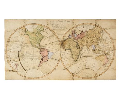
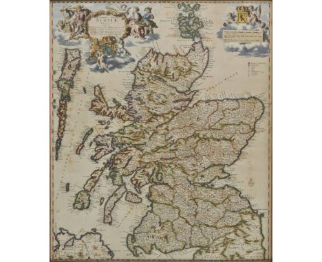
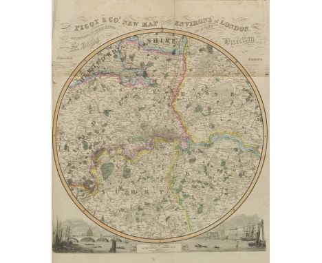
*Jigsaw map. The Terrestial Globe, Divided into Empires, Kingdoms & States, from the best Authorities Together with the new Discoveries, of the different Circumnavigators, By Thomas Kitchin, Hydrographer to his Majesty, J. Wallis, Published as the Act directs, Jany 1st. 1787, wooden dissected map of the world, hand-coloured, approximately sixty-one pieces, missing four pieces (Brazil, Siam, Spain, Germany & Low Countries), Scandinavia replaced with a blank piece, some warping (and occasional water-staining), somewhat dusty and spotted, 40 x 74.5cm (15.75 x 29.25ins), contained in original wooden box (damaged and repaired), with printed paper label (rubbed), together with Wallis's New and Correct Map of the Post Roads of England & Wales, John Wallis, 1798, wooden dissected map, hand-coloured, approximately eighty-four pieces, complete but for the small tip of Merionethshire, some warping, dusty and with occasional worm damage, 55 x 47.5cm (21.75 x 18.75ins), contained in wooden box with sliding lid (probably original but no trace of label), plus Wallis's New Dissected Map of England, 1815, wooden hand-coloured map, missing Huntingdonshire, in original wooden box with sliding lid and printed paper label (with some losses), plus Warrented Perfect Improved Dissected Maps... England and Wales, Wallis, circa 1826, wooden hand-coloured map, missing four pieces (Nottinghamshire, Northamptonshire, Monmouthshire & Glamorganshire, and Cardiganshire; the latter three replaced with blanks), one piece chipped and one (Worcestershire) with a small surface loss, in original wooden box with sliding lid (repaired) and printed paper label (worn), plus Superior Dissected Maps by W. Peacock: England & Wales, wooden jigsaw, three pieces replaced with blanks (Cardigan Bay, Isle of Man, Oxford) , some small surface losses, one piece with its interlocking tab broken off but present, dusty with some marks, in original wooden box with pictorial lid (repaired), plus Superior Dissected Maps: Scotland, wooden hand-coloured map, complete, in original pictorial wooden box (repaired) with folded key map Provenance: From the collection of Percy H. Muir. (6)

Lot 67

British Empire. Bartholomew (J.), British Empire throughout the World, exhibited in one view, published A.Fullarton, circa 1860, colour lithographic map with engraved decorative borders, slight spotting and staining, occasional marginal closed tears, 430 x 530 mm (1)

Loading...Loading...
  • 109198 item(s)
    /page

Recently Viewed Lots