We found 109182 price guide item(s) matching your search

Refine your search

Year

Filter by Price Range
  • List
  • Grid
  • 109182 item(s)
    /page

Lot 42

A bone puzzle box with Scrimshaw decoration of two ships and a world map, 3¼'' long

Lot 781

17TH-CENTURY MAP by Timothy Pont, titled 'The Upper Ward of Clyde-Dale', hand-coloured and framed, 40cm high, 53cm wide

Lot 229

A small pre WWII poster - NAZI WAR AIMS showing a map of Europe "Revealed by Secret Nazi Map circulated in 1937...."37.5cms x 50cms ++folded, slight creasing to bottom right margin otherwise good

Lot 287

A WWI Princess Mary brass Christmas tin containing the original card and together with two colour printed cotton handkerchiefs "Map of Seat of War", flags of Allies and anthems

Lot 64

Kellys Directory Somerset 1910, with folding map in the front ++covers worn

Lot 59

A collection of 19th century and other ceramics including a set of six early 19th century tea bowl of wrythen moulded form with pink, grey and yellow trailing leaf and floral border decoration, with painted numbers to base 183 together with four matching saucers and a matching cream jug, a 19th century coffee can with painted decoration on a blue and gilt ground, a match strike/pipe stand with printed map showing the Environs of Liverpool, with printed mark to reverse for MacIntyre & Co, two Prattware pot lids, a small collection of miniature German tea wares with painted rose decoration including teapot, covered sugar bowl, etc and a 19th century continental stand with painted and encrusted floral decoration, etc

Lot 676

An early 19th century wall hanging map of the county of Wiltshire by C Greenwood, published 1820 with canvas backing, 150 x 116 cm approx

Lot 434

Gerardus Mercator (1512-1594) - Coloured engraved map - "Scotia Regnum", 13.75ins x 15.825ins, in gilt frame and glazed Note : The original map plates were bought in 1604 by Jodocus Hondius who published enlarged editions of this and other works by Mercator. This example was probably published in Amsterdam circa 1630
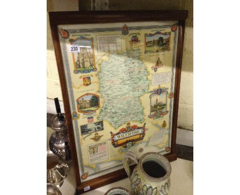
Lot 438

Thomas Bowen (fl. 1767-1790) - engraving - Map of"East Indies", showing Borneo, Philippines, India, Sumatra and Taiwan, 7ins x 11ins, framed and glazed

Lot 439

17th Century School - Coloured engraving - Map of Canterbury, 11.5ins x 16.5ins (with bookworm damage - stuck down), in later Hogarth frame

Lot 462

Landmarks of Map Making, Wordsworth Editions Ltd, 1989 (one volume), Ralph Hyde - "A Prospect of Britain - The Town Panoramas of Samuel and Nathaniel Buck", Pavilion Books Ltd, 1994 (one volume), and eight other volumes relating to maps

Lot 230

A framed and glazed map of Wiltshire, commissioned for the Wiltshire Regiment in contemporary frame by David Joel Limited, Kingston Bypass, London, the map by permission of the Rt. Hon. R. S. Hudson, C. H. M. P. Minister of Agriculture and Fisheries, 1940 - 45, designed and drawn by Ernest Clegg and printed by Waddington 1946.

Lot 443

Eman Bowen, engraved with later hand colouring, map of the six counties of North Wales, dated 1777, 43 x 53cm

Lot 382

A framed and glazed map of France together with a framed oil on board depicting night time country scene and a print entitled Greenock by lamplight together with various other prints including limited edition print of Brighton pier

Lot 199

A Britannica Saxonica map of England and Wales together with a facsimile map of England and Wales

Lot 200

A framed and glazed map of England together with a framed map of the world

Lot 216

An early framed map of the tip of Wales

Lot 130

John Speed - Map of Rutland. Early example in gilt frame, 25cm x 22cm in all

Lot 133

An interesting collection of German and British World War Two (WWII) ephemera to include Strassenkarte von Deutschland 1940 (map), The Far East (map), Order of Service, end of war Thanksgiving, 6th Airborne Division held in the Nikolaikirche at Wismar May 6th 1945, Führergeschenk für Fronturlauber German ration cards) and other papers

Lot 57

An 18th century map with later hand colouring, County of Middlesex, London, J Bowles Bowles, with inset armorials, and dedicated to the Moft Noble Thomas Holles Pelham, Duke of Newcastle, 53.5 cm x 73.5 cm, framed under glass

Lot 59

John Speed (1552 - 1629) - a period engraved map with later hand colouring, Worcestershire Described, 1610, London, John Sudbury & George Humble, engraved by George Humble, with inset town plan, armorials, and vignette of battle scene, 39 cm x 52 cm, framed under glass - Est £80 - £120

Lot 114

A hand tinted map of the Norfolk and Suffolk coast line, Master and Wardens of the Trinity House of Deptford Strond This Mapp is most humbly dedicated and presented by Capt. G. Collins I. Harris Sculp, 25" x 39"

Lot 316

Old engraved map of Hampshire by Hole After Norden Handcoloured, 29cm x 32cm

Lot 319

Map after Blaeu, Amsterdam

Lot 2803

OLYMPIC Map Error. $10.00. 1974. Encapsilated. A gem example. Ex. MOORE's TICF, Nov. 14-15, 2003. Lot #1259.

Lot 144

Four 1950's/60 Picture Show annuals, another 1929, a Who's Who on the Screen book, a Peter Pan and Wendy book and an old cycle map of Surrey, cigarette cards, etc

Lot 326

L Lewis, 19th century mountain view with figures walking on a river bank, signed and dated 1882, 25cm by 47cm, and a reproduction map of Surrey, 37cm by 52cm

Lot 333

An 18th century map of Pembrokeshire with heraldic shields, coloured borders and place names, 46cm by 57cm

Lot 346

A John Speed map, 'Cardigan Shyre', partly coloured and with 'key' to reverse, in double glazed frame, image size 38cm by 50cm

Lot 400

John Speed, a map of Huntingdon, dated 1610, 51 x 39cm, another by Robert Morden together with five other maps of Huntingdon

Lot 402

A 17th century engraved Cambridge map by Van den Keere, and a county map by Morden; with After Farington, Richmond Hill, coloured aquatint (3)

Lot 447

T Kitchen, a map of England, engraved for Warpolle's News and Complete British Traveller

Lot 895

A collection of cigarette cards in folders and an 1835 Atlas (repaired) and a framed County map

Lot 403

Robert Morden, 18th century framed map of Essex 59cm x 49cm

Lot 404

J Cary, framed map of Essex dated 1793 40cm x 35cm

Lot 405

An early hand tinted map of Essex by Thomas Moule circa 1836 indicating the first railway lines 35cm x 28cm

Lot 426

A framed map of Leigh On Sea 65cm x 53cm

Lot 276

A mounted 18th century map of Turkey by J Jefferys circa 1750. 20cm x 26cm

Lot 180

Map of The Countie and Citie of Lincoln as Described with the Armes of Them... after John Speed

Lot 184

Map of The Countie and Citie of Lincoln as Described with the Armes of Them... after John Speed

Lot 185

Map of The Countie and Citie of Lincoln as Described with the Armes of Them... after John Speed

Lot 186

A New Map of the County of Lincoln divided into Wapontakes &c. London Printed for C.Smith No 172 Strand January 6th 1801

Lot 189

A framed & glazed map of Lincolnshire, 44 x 38cm

Lot 285

A framed map and 2 framed documents

Lot 355

A framed and glazed official Admiralty map

Lot 1200

A leather and card Philips' Patent Orrery, the embossed leather covering inscribed 'For finding the position of the various planets for every hour in the year', circular revolving disc with celestial map, twin index arms, the back printed with instructions, c. 1920, 10in (25cm) diameter.

Lot 350

A pair of 19th Century black and white engravings of Shirburn Castle, Oxfordshire, and a map of the British Isles after Homman

Lot 355

A replica map of the North Sea, two other modern maps of Buckinghamshire and the British Isles and a watercolour, portrait of a young African girl, signed and dated 1940

Lot 360

A group of WWII related items, including the Defence Medal and War Medal engraved to Capt. E.M.K. Walsworth-Bell, reconnaissance training photographic prints, Operation Buffalo Indoctrinee Force restricted lecture documentation from 1956, a canvas map carrier with maps of Burma, and a collection of Seaforth Highlander buttons, plus Kings African Rifles badges, and dog tags (parcel)

Lot 409

Of WWII RAF & 614 Squadron interest: A WWII flight log book and other interesting ephemera, this fascinating lot contains a log book from Flight Lieut. G.G. Graham dating from 1944 & 1945 containing well drafted comments and photographs of missions flown, together with two later 1960s training flight log books, a collection of personal letters and several candid photographs and reprints, postcards, a map, two hand worked advertising posters and more (parcel)

Lot 663

Oliver Merijon: Limited edition print of a landscape (signed and numbered 48/200 to lower border), together with a print titled probably Elizabeth Blackadder "Anemones and Lilies" and a map of Hong Kong.

Lot 749

Boxed brass nautical map reader

Lot 609

An engraved map of the County Palatine of Chester, by Robert Morden, with hand colouring.

Lot 654

An antique engraved map of Cambridgeshire, by Thomas Kitchin, coloured by hand; an antique engraved map of Westmoreland with hand colouring; together with antique engraved maps of Derbyshire and Lancashire, one unframed. (4)

Lot 663

A colour print - "Fisherman's map of salmon pools on the River Tweed", after Nigel Houldsworth; together with a limited edition colour print - "The Northumbria Quilt". (2)

Lot 687

A map of Northumberland by Christopher Saxton and William Hole; together with an Edwardian photograph of the staff at T.M. Sparks Co. Bookbinders Shop, inscribed with date 1909. (2)

Lot 508

'The Dinner Party', coloured print, together with a map of Spain, 'Espana Antiqua' after Sydney Hall. (2)

Lot 514

Two Guinness advertising lap trays, map of Germany printed on linen, Great Western Railway map of Swansea docks, and a reproduction Japanese print. (5)

Lot 561

'Charta Caelestis', a celestial map engraved on metal. Framed.

Lot 1414

A 19th Century Framed Needlework Map of England and Wales divided into counties, frame 19 wide

Loading...Loading...
  • 109182 item(s)
    /page

Recently Viewed Lots