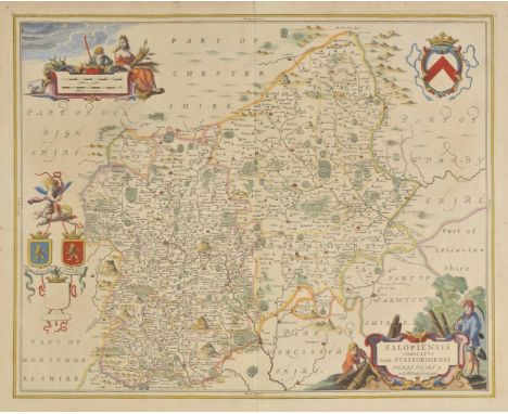

Staffordshire. Jansson (Jan), Salopiensis comitatus cum Staffordiensi. Shropshire & Staffordshire, published Amsterdam, circa 1650, engraved map with contemporary hand colouring, slight toning, slight spotting to margins, short split at base of central fold, 425 x 535 mm, Latin text on verso, together with Saxton (Christopher & Kip William), Staffordiae comitatus pars olim Cornauiorum, [1607], hand coloured engraved map, strapwork cartouche and mileage scale, toned overall, 270 x 375 mm, Latin text on verso, with Blome (Richard), A Mapp of Staffordshire with its Hundreds, [1673], hand coloured engraved map, some mount staining, 330 x 245 mm, plus Moll (Herman), Staffordshire, circa 1724, hand coloured engraved map, some creasing, 320 x 200 mm, with Kitchin (Thomas), Staffordshire drawn from an accurate survey..., [1786], hand coloured engraved map, mount stained, 220 x 170 mm, and Bickham (George), Staffordshire, circa 1796, hand coloured pictorial panoramic map, mount stained, 235 x 150 mm, and Morden (Robert), Staffordshire, [1695 or later], hand coloured engraved map, laid on later paper, 435 x 380 mm (7)
We found 109182 price guide item(s) matching your search
There are 109182 lots that match your search criteria. Subscribe now to get instant access to the full price guide service.
Click here to subscribe- List
- Grid
-
109182 item(s)/page

*World. Walker (J.), Map Showing the Steam Communication and Overland Routes between England, India, China & Australia, published Wm. H. Allen & Co., 1856, large engraved map with contemporary outline colouring, sectionalised and laid on linen, remains of old juvenile pencil scribblings, two scratch marks above New Zealand, 700 x 1290 mm, framed and glazed (1)
![Osaka Shosen Steamship Company. Saikin Manshu Shashincho [The Latest Photo Album of Manchuria], 4th edition, printed in Dalia](https://cdn.globalauctionplatform.com/89b51f02-b445-45fa-8b99-a6d000acba4b/8aaa97cd-1ac5-45f7-93a6-75ae20e50a2b/468x382.jpg)
Osaka Shosen Steamship Company. Saikin Manshu Shashincho [The Latest Photo Album of Manchuria], 4th edition, printed in Dalian, 1931, folding colour printed map, 86 photographic illustrations, including street scenes, buildings, ports, monuments, landscape and coastal views, industry, etc., some in colour, each with acccompanying leaf of descriptive text in Japanese and English, original decorated brown mock-crocodile skin cloth binding, with yapp edges, sewn as issued, very slightly rubbed, oblong 8vo (145 x 195 mm) (1)

England & Wales. Speed (John), The Kingdome of England, published Thomas Bassett & Richard Chiswell, circa 1676, hand coloured engraved map with eight engraved costumed figures to vertical margins, a few repaired marginal closed tears, some soiling largely confined to margins, margins strengthened on verso with archival tissue, 390 x 520 mm, English text on verso (1)

London. Gill (MacDonald), Wonderground Map of London Town, published The Westminster Press, circa 1928, photolithographic colour printed map, a few closed tears and splits along old folds affecting image, 740 x 930 mm This is an example of the slightly smaller and later edition of Gill's original 1913 map. There is a 1924 edition which is assumed to have been altered to help the promotion of the 1924 British Empire Exhibition that was held at Wembley between April and October of that year. It can be identified by a sign saying:- 'On To Wembley' and an empire lion in the top left hand corner below the man pushing a bus. This example is a slightly later state with a greyhound replacing the lion. Greyhound racing started at Wembley in 1927 so this edition probably dates from 1927 or 1928. The map remains highly stylised and whimsical and was held in great affection by Londoners. It was originally commissioned by The London Underground and was designed to be displayed in tube stations. The intense pictorial content of the map caught the public's imagination and as a result Gill is often credited with creating a resurgence of the genre of decorative map making. Much work and research has been done by Roderick Barron and Bryars & Bryars on the maps of the Underground and the work of Macdonald Gill and I am also grateful to Claire Dobbins book, London Underground Maps: Art, Design and Cartography. (1)

Hungary. Speed (John), The Mape of Hungari, published Thomas Bassett & Richard Chiswell, circa 1676, hand coloured engraved carte-a-figure map, eight costumed figures to vertical margins and four oval vignettes of principal cities along upper horizontal margin, slight toning and strengthening on verso to central fold, 395 x 520 mm, English text on verso (1)
Skelton (Joseph). Engraved Illustrations of the Principal Antiquities of Oxfordshire, from Original Drawings by F. Mackenzie ..., published Oxford, 1823, decorative engraved frontispiece, calligraphic title with inset vignette, dedication and list of subscribers, small near contemporary ownership sinature to front free endpaper, uncoloured engraved map of Oxfordshire, forty-nine engraved plates on india wove and numerous engraved vignettes to text throughout, index, addenda et corrigenda bound at rear, slight spotting, upper hinge cracked, all edges gilt, contemporary half morocco on marbled boards, ornate gilt decorated spine, bumped and a little worn at extremities, folio Large paper copy. (1)

Carnarvonshire. Speed (John), Caernarvon both Shyre and Shire-towne with the ancient Citie Bangor described, published John Sudbury & George Humble, [1616], uncoloured engraved map, inset town plans of Carnarvon and Bangor, one rust mark and a small printers fold affecting image, 385 x 515 mm, Latin text on verso (1)
Carmarthenshire. Speed (John), Caermarden both Shyre and Towne, published John Sudbury & George Humble, [1616], hand coloured engraved map, inset town plan of Carmarthen, strapwork cartouche, mileage scale and compass rose, some mount staining, one small hole to image, slight surface abrasion, central fold strengthened on verso, 390 x 515 mm, Latin text on verso, together with Denbighshire, published Thomas Bassett & Richard Chiswell, circa 1676, uncoloured engraved map, inset town plan of Denbigh, lower margin and central fold strengthened on verso, 385 x 510 mm, English text on verso (2)
![British Isles. Munster (Sebastian), Von den Britannischen Insula, [1588 or later], hand coloured woodcut map, originally publ](https://cdn.globalauctionplatform.com/89b51f02-b445-45fa-8b99-a6d000acba4b/7ad84fd7-047f-4ca4-870d-802f33e93587/468x382.jpg)
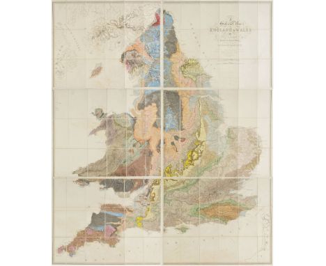
England & Wales. Greenough (George Bellas), A Physical and Geological Map of England & Wales by G.B.Greenough Esq. F.R.S., President of the Geological Society, published by the Geological Society, 2nd edition, 1839, engraved map on six sheets, sectionalised and laid on linen, contemporary hand colouring, calligraphic title, slight offsetting, separate double page sheet of 'Index of colours' and a separately printed 'Memoir of a Geological Map of England...,' 2nd edition, 1840, publisher's printed paper wrappers, pamphlet size 215 x 140 mm, each map sheet approximately 640 x 810 mm, all contained in a contemporary cloth book box with manuscript paper label to spine A map which was controversial at the time of its publication in that Greenough was accused of plagiarising William Smith's earlier and ground breaking geological survey and map of 1815. Greenough was stung enough by the critisicm to issue a written defense of his actions which was published in 'Memoir of a Geological Map of England: to Which are Added, an Alphabetical Index to the Hills, and a List of the Hills Arranged According to Counties (1820)'.Smith's low social staus and background resulted in his work being largely ignored and the Geological Society of London did indeed plagiarise the map, undercutting Smith's asking price, which eventually pushed Smith to financial ruin and the debtor's prison. Recognition of his role as 'The Father of English Geology' would only follow much later in 1831 when Smith was awarded the Woolaston medal by the Geological Society. Greenough's map is important in its own right and is now recognised as a separate piece of scholarship but unlike Smith it involved no surveying but relied on other surveyors sending him information which he then collated. (1)

Luffman (John). A New Pocket Atlas and Geography of England and Wales, Illustrated with fifty-five Copper plates shewing all the Great Post Roads with the Towns & Villages situated thereon..., 2nd edition, published Lackington Allen & Co., 1806, engraved title, preface and code sheet, fifty-four circular county maps with descriptive text below and a double page engraved map of England & Wales (complete), all with contemporary hand colouring, pencil annotation to the text the English counties updating the population figures, bookplate of Marshall Laird, later half morocco, retaining original marbled boards with contemporary printed title label to upper board, 8vo Scarce. Chubb CCCIX. (1)
![England & Wales. Mercator (Gerardus & Hondius Jodocus), Anglia Regnum, [1636], hand coloured engraved map, slight creasing, o](https://cdn.globalauctionplatform.com/89b51f02-b445-45fa-8b99-a6d000acba4b/8e11df26-ed47-4587-e107-cf231a7c01eb/468x382.jpg)
![British Isles. Rosaccio (Giuseppe), No title, but 'Ingilterra' is printed in the centre of the map, [1595 or later], miniatur](https://cdn.globalauctionplatform.com/89b51f02-b445-45fa-8b99-a6d000acba4b/23ff8216-b100-49aa-aaf7-608ea846f2e7/468x382.jpg)
British Isles. Rosaccio (Giuseppe), No title, but 'Ingilterra' is printed in the centre of the map, [1595 or later], miniature woodblock map, laid on later card, 130 x 85 mm R.W.Shirley, Early Printed Maps of the British Isles. 1477 - 1650, no.188. The map was published first in Florence in 1595 and then again in Verona, Treviso, Venice and Bologna up until 1724. (1)


Denmark. Speed (John), The Kingdome of Denmarke, published George Humble, circa 1627, hand coloured engraved 'carte-a-figure' map, ten costumed figures to vertical margins,,six oval vignettes of the principal cities to upper horizontal margins, slight creasing, two pin holes in image, 390 x 510 mm, English text on verso (1)

British Isles. Waldseemüller (Martin), Untitled map of the British Isles, published Strasbourg, circa 1520, Ptolemaic woodblock map with early hand colouring on a trapezoidal projection with Scotland orientated to the east, 410 x 565 mm Rare. R.W.Shirley, Early Printed Maps of the British Isles 1477 - 1650, no. 13. (1)
Champlain (Samuel de). The Works of Samuel de Champlain, Reprinted, Translated and Annotated by Six Canadian Scholars under the General Editorship of H.P. Biggar, 7 volumes, including map portfolio, University of Toronto Press, 1971, folding maps and illustrations, top edges gilt, original red cloth gilt, 8vo, together with American Indian Ethnohistory, Garland Series, 47 volumes, a broken run, circa 1974, folding maps and plates, etc., all original publisher's green cloth, lettered in red, very slightly rubbed, 8vo, including California Indians, 7 volumes only, Apache Indians, 5 volumes only, Chippewa Indians, 5 volumes only, Paiute Indians, 4 volumes, etc., plus Hafen (LeRoy R. & Ann W. Hafen). The Far West and Rockies Historical Series 1820-1875, 15 volumes, Arthur H. Clark, Glendale, California, 1954-61, maps and illustrations, original green cloth, 8vo, and other facsimile editions of American travel, including 43 volumes from the March of America Facsimile series, all bound in original blue cloth gilt, with remains of library labels to spines, and inkstamp to title, and Classics of the Old West series, 8 volumes, Kraus Reprints series, etc., all original cloth or mock leather, mainly 8vo (6 shelves)
![[Sandys, George]. A Relation of a Journey begun An Dom. 1610. Foure Bookes Containing a Description of the Turkish Empire of](https://cdn.globalauctionplatform.com/89b51f02-b445-45fa-8b99-a6d000acba4b/128ab7ca-82ce-4582-e177-cee1afa34485/468x382.jpg)
[Sandys, George]. A Relation of a Journey begun An Dom. 1610. Foure Bookes Containing a Description of the Turkish Empire of Aegypt, of the Holy Land, of the Remote Parts of Italy, and Islands Adjoyning, 3rd edition, London: Ro. Allot, 1627, engraved title within architectural border & folding map (with repaired central fold), engraved prospect plate only (torn with half plate lacking, also without plate intended to fill blank area on D4 verso, as often), numerous engraved illustrations throughout, manuscript to final leaf of text, final blank deficient, some marks and dust-soiling, 19th century half calf, joints cracked, small folio, (STC 21728), together with Carne (John), Letters from the East: Written during a recent tour through Turkey, Egypt, Arabia, The Holy Land, Syria, and Greece, 2 volumes, 2nd edition, 1826, hand-coloured aquatint frontispiece to volume 1, ownership signature to upper blank margin of title, contemporary calf, some loss to volume number labels, rubbed, 8vo, plus Virginian, The American Wanderer, Through Various Parts of Europe, in a Series of Letters to a Lady, (Interspersed with a Variety of interesting Anecdotes) by a Virginian, London: J. Robson, 1783, front free endpaper loose, contemporary marbled calf, loss to title label on spine, joints cracked, 8vo (4)
![Cary (John). [New and Correct English Atlas: being a New Set of County Maps from actual surveys..., 1787], advertisement lea](https://cdn.globalauctionplatform.com/89b51f02-b445-45fa-8b99-a6d000acba4b/2980bd54-bb07-46af-e4da-69db571ff325/468x382.jpg)
Cary (John). [New and Correct English Atlas: being a New Set of County Maps from actual surveys..., 1787], advertisement leaf, contents leaf, 46 engraved county maps, each dated September 1st 1787 (including map of South Britain, North Wales and South Wales), all hand-coloured in outline, large folding table of distances at end (one or two tears to folds), Junctions, market towns, post towns and list of subscribers at end, occasional marks and soiling, all maps with central vertical fold, and hinged, bound in the form of a saddle atlas in contemporary sheep, worn with spine deficient and lower cover missing, upper cover detached, tall 4to (295 x 140 mm) (1)

Cary (John). Cary's Traveller's Companion, or a Delineation of the Turnpike Roads of England and Wales; shewing the immediate route to every Market and Borough Town throughout the Kingdom..., 7th edition, 1817, calligraphic title, advertisement and contents, forty-three (complete) engraved maps with contemporary outline colouring, one folding map (Yorkshire) with a short closed tear, index and routes bound at rear, bound with Cary's New Itinerary or an accurate Delineation of the Great Roads, both Direct and Cross throughout England and Wales, with many of the Principal roads in Scotland..., 7th edition, 1817, title and folding engraved map of England & Wales with contemporary hand colouring, closed tear affecting image and six additional folding maps with contemporary outline colouring, hinges strengthened, book plate of E.P.Westby Esq., contemporary tree calf, re-backed retaining original gilt decorative spine, bumped, 8vo Chubb. CCLXXX. (1)

*Ireland. Petty (William), The County of Downe, circa 1685, hand coloured engraved map, strapwork cartouche, very slight spotting, 475 x 375 mm, mounted, framed and glazed A good example of the earliest printed map of County Downe. The 'Down survey' was executed by Dr. William Petty in 1655-56 and was published in 'Hiberniae Delineatio', the first printed atlas of Ireland. The engraver is unknown. Scarce. (1)
Waugh (Evelyn). Labels, A Mediterranean Journal, 1st edition, 1930, black and white plates including frontispiece, original cloth, spine and upper margin of lower board partly faded, together with Remote People, 1st edition, 1931, black and white plates and two folding maps, some heavy spotting, original cloth gilt, a little rubbed and marked, plus Ninety-Two Days, 1st edition, 1934, portrait frontispiece and plates from photographs, folding map, original cloth, slightly rubbed and darkened on spine, together with Waugh in Abyssinia, 1st edition, 1936, scattered minor spotting, original cloth gilt, plus Robbery under Law: The Mexican Object-Lesson, 1st edition, 1939, original cloth gilt, slightly rubbed, upper panel of dust jacket (frayed at edges) loosely inserted, plus When the Going was Good, 1st edition, 1946, colour portrait frontispiece, folding map, original cloth in dust jacket, a little rubbed and soiled, brown tape closed repairs to verso, plus A Tourist in Africa, 1st edition, 1960, black and white plates from photographs, original cloth in dust jacket, a little soiled and browned, all 8vo (7)

Americas. Bertius (Petrus & Tavernier Melchior), Carte de L'Amerique Corrigée, et augmentée dessus toutes les aultres cy devant faictes par P. Bertius, [1627], uncoloured engraved map, two inset maps of the polar regions, decorated with numerous galleons and sea monsters, slight staining, 385 x 500 mm P.D.Burden. The Mapping of North America, no.218, state 1. A rare separately published map of America, published by Melchior Tavernier in Paris in 1627. (1)
Wraxall (Nathaniel William). A Tour Through Some of the Northern Parts of Europe..., 2nd edition, 1775, black and white folding map frontispiece, some minor marks, contemporary full calf, boards slightly marked, spine rubbed to head and foot, 8vo, together with Blane (William), Cynegetica, or Essays on Sporting: consisting of Observations on Hare Hunting..., new edition, 1788, black and white engraved frontispiece and half title, wax stains to fore-edge from front endpaper to C2, some other light marks, front board partially detached, contemporary boards, covers marked, spine cracked with some loss, 8vo, and Marvell (Andrew), The Works..., volumes 1 & 2, 1726, black and white portrait frontispiece to volume 1, some light spotting and offsetting, bookplates to front endpapers, uniform contemporary full calf, boards partially detached and rubbed, spines rubbed with minor loss, small 8vo, plus other 17th-19th century literature, including Le Cabinet Des Fées, ou collection choisie, by A. Genéve, volumes 1-41, 1785-89, later uniform gilt decorated green half morocco, 8vo, mostly leather bindings, some foreign language and odd volumes, condition is generally good/very good, 8vo/folio (3 shelves)
Tolkien (J.R.R.). The Fellowship of the Ring, 1966; The Two Towers, 1966; The Return of the King, 1966, 2nd editions, folding map at end of each (small marginal stain to Return map), a few light spots to Fellowship, previous owner signature to Return, original red cloth (small bump and tiny tear to Fellowship lower board edge), dust jackets, spines a little rubbed at ends, a few small indentations to Fellowship, 8vo (3)

Owen (George). The Description of Pembrokeshire, 1892, black and white folding map to front, some minor toning, modern endpapers, later gilt decorated green half calf, 8vo, together with Westall (W. Percival), Country Rambles..., 1903, numerous black and white illustrations, later inscription to front endpaper, original gilt decorated green cloth, spine slightly rubbed to head and foot, 8vo, and Manning (Samual), Swiss Pictures Drawn with Pen and Pencil, new edition, 1891, numerous black and white illustrations, including map, some minor spotting, bookplate to front pastedown, original gilt decorated green cloth, spine slightly rubbed to head and foot, 8vo, plus other mostly 19th century literature and reference, many leather bindings, some gilt decorated cloth, some odd volumes, condition is generally good, 8vo (3 shelves)
Waugh (Evelyn). Robbery Under Law: The Mexican Object-Lesson, 1st edition, 1939, original cloth gilt, a little rubbed, together with When the Going was Good, 1st edition, 1946, colour portrait frontispiece and folding map, original cloth, slightly rubbed and soiled, plus Georgian Stories, 1926, containing 'The Balance', by Waugh, some spotting, contemporary inscription to front free endpaper, original cloth, a little rubbed and faded on spine, all 8vo, plus other Evelyn Waugh interest, including UK and American editions, reprints, etc. (approx. 65)

Kitchin (Thomas & Jefferys, Thomas). The Small English Atlas being a New and Accurate Sett of Maps of all the Counties in England and Wales, published Robert Sayer, John Bennett, John Bowles and Carrington Bowles, [1775], decorative calligraphic title, preface (with index and table of explanation on the same page), map of England & Wales and a map of the rivers of England, and forty-eight (complete) uncoloured engraved maps with descriptive text below image, slight finger soiling and staining largely confined to margins, later endpapers, modern quarter morocco, 4to The third edition has no date on the title page but must have been issued sometime after 1774 when Robert Sayer joined John Bennett in partnership. It is probably this edition that was advertised in the Sayer and Bennett catalogue of 1775. The maps differ from the earlier editions in that the borders of the hundreds, wapentakes and some canals and roads have been added and the list of towns below the maps is now alphabetical. Not in Chubb but c.f. Chubb CXCII for 1749 edition. (1)

*Germany. Fries (Lorenz) Europae Tabula quarta continet Germaniam magnam, circa 1540, uncoloured woodblock map on a trapezoidal projection, 310 x 380 mm, mounted, framed and double glazed, Latin text on verso This map of Germany, Poland and surroundings is a Lorenz Fries edition based on Waldseemuller's Ptolemaic atlas map, originally published in "Geographie Opus Novissima", first published in 1513. The map extends from the Rhine River east to the Vistula River and south as far as the Danube covering what would be modern day Denmark, Germany, Poland, Czech Republic, Austria, Slovakia and Hungary. (1)

World. Bowen (Emanuel), A New & Accurate Chart of the World. Drawn from Authentic Surveys assisted by the most approved modern maps & charts & regulated by astronl. observations, circa 1750, uncoloured engraved map on a Mercator projection, near contemporary ownership signature to upper right margin, 365 x 445 mm, together with Bowen (Thomas), The World including the late discoveries by Capt. Cook and other circum navigators, carefully laid down to the present time, circa 1780, uncoloured engraved map on a hemispheral projection, inset map of the North Pole, decorative margins with the corners decorated with globes, an orrery and a compass, old folds, slight creasing, right hand margin frayed with slight loss and repaired, 290 x 460 mm, with Bowen (Thomas), A New and Complete chart of the World, Displaying the Tracks of Capt. Cook and other modern Navigators, circa 1780, uncoloured engraved map on a Mercator projection, old folds, 335 x 470 mm (3)
*Morris (Rev. F.O.). A Series of Picturesque Views of Seats of Noblemen and Gentlemen of Great Britain and Ireland..., volumes 2,3,4,6 & 7 (only), circa 1880, additional decorative titles, numerous chromolithographic plates, all edges gilt, publisher's decorative cloth gilt, a little worn at extremities, 4to, together with [Adams (John),] [The Young Lady's and Gentleman's Atlas..., 1805], lacking title and preliminaries, twenty-one (only) double page engraved maps with contemporary hand colouring, disbound, 8vo, with Walker (John), Elements of Geography and of Natural and Civil History, 2nd edition, 1795, ten uncoloured engraved folding maps, some dust soiling and creasing, contemporary calf, rubbed and worn 8vo, plus Bingley (Rev. W.), North Wales, delineated from two excursions..., 2nd edition, 1814, engraved frontispiece, folding engraved map with contemporary outline colouring, lacking some pages of text, near contemporary boards with paper label to spine, rubbed and worn, 8vo, with one other volume similar, 8vo, and a mixed collection of approximately ninety genre, social and topographical engravings mostly relating to Wales, originally published in 'The Graphic' and 'The Illustrated London News', mounted, various sizes and condition Sold as a collection of prints and maps, not subject to return. (approx.100)
World. Bowen (Thomas), A Mercator Chart of the World, circa 1780, uncoloured engraved map, old folds, slight creasing, some fraying to upper horizontal margin, originally published in Middleton's 'Complete System of Geography', 335 x 445mm, together with Rapkin (J.), The Wolrd on Mercator's Projection, Published John Tallis, circa 1860, engraved map with contemporary outline colouring, 265 x 355 mm, with Walker (J & C), The World on Mercator's Projection, published S.D.U.K., 1841, engraved map with contemporary outline colouring, slight spotting and dust soiling, 405 x 610 mm, plus Annonymous, A Correct Map of the World with the latest Discoveries, 1799, engraved map on a hemispheral projection, sprase colouring, old folds, 165 x 270 mm (4)
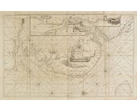
Sea chart. Collins (Captain Greenville), Untitled chart of the East coast of England, circa 1700, large uncoloured engraved chart, running from Dover to the River Humber, large inset map of the River Thames and London, dedication and mileage scale placed on the sails of a large inset vignette of a man-of-war, old folds, slight dust soiling, very small closed tears along old folds, 600 x 940 mm (1)


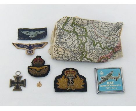
Militaria:- A Royal Navy cloth and bullion officer's cap badge; a similar King's crown officer's cloth and bullion cap badge from Royal Air Force; a Royal Air Force eagle arm badge, embroidered pale blue on Air force blue; A WWII German breast eagle, probably Kriegsmarine, embroidered blue on white; an Iron Cross with swastika and dates "1813" and "1939" and suspension ring; a metal and enamel commemorative car badge entitled "RAF Bomber Command 1939-1945"; a small yellow coloured metal swastika pendant stamped "9"; and a WWII pilot's silk escape map, one side printed with map of France, the reverse with map of Germany which also includes Czechoslovakia and parts of Austria, Hungary, Poland and the Baltic (8)


I.A.S.: O'Flaherty (Rod.) A Chorographical Description of West or H-Iar Connaught, ed. James Hardiman. 4to D. 1846. First Edn., engd. map frontis; O'Donovan (J.)ed. The Tribes and Customs of Hy-Many, Commonly called O'Kelly's Country. 4to D. 1843. Engd. map frontis, fold. tables; The Miscellany of the Irish Archaeological Society, Vol. I only, 4to D. 1846, all recent mor. backed boards. (3)

Aringhi (Paul) Roma Subterranea Novissima, in qua Post Antonium Bosium Antesignanum, Jo Severanum Congreg. Oratorii Presbyterum, Et celebres alias Scriptores ... Lg. Folio 2 vols. in one, Paris 1659. Add engd. title & one hf. title. Lg. fold. map, wd. cut illus. thro.-out text, 62 full page engd. illus. 45 hf. page engd. illus. (2 leaves pp 91/92, & pp 93/94 lacking, & possibly one plt. at page one), uncut, orig. plain boards. (1)* Preface signed by Fr. Luke Wadding.

Dublin & Vicinity: Starrat (M.) History of Ancient and Modern Dublin; or Visitor's Guide to the Metropolis of Ireland. 12mo D. n.d. [c. 1820] First Edn., wd. cut frontis & illus; Irwin (G.) A Historical and Descriptive Guide to the Irish Metropolis, 12mo L. 1853, fold. map, illus.; & 4 other Guides etc. (6)

Scottish interest: Gazetteer of Scotland Containing a Particular Description of the Counties, Parishes, Islands, Cities, Towns, Villages, Lakes, Rivers, Mountains, Vallies, etc in the Kingdom. 8vo Edin. 1806. Second Edn., fold. hd. cold. map, adverts at end, cont. sprinkled calf. (1)* Bookplates of Earl of Ormonde & Ossory, and C.H. Butler Clarke, Ullcombe.


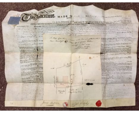
Dublin Indenture of 1804Weldon (James) Printed Indenture on vellum dated 4 January 1804, whereby James Weldon of Dublin, tin plate worker, grants premises in Westmorland Row, Ranelagh, to George Oakley of the same, gent. A lease for two lives of at a rent of £32. Bounds and dimensions given. Sketch map of the property attached. As a m/ss. (1)

I.A.S.: O'Donovan (John) The Tribes and Customs of Hy-Many commonly called O'Kelly's Country, 4to D. 1843. First Edn., engd. map frontis; also The Genealogies, Tribes and Customs of Hy-Fiachrach, commonly called O'Dowda's Country, 4to D. 1844., engd. fold. map frontis, orig. cloth, good; together with I.A.S.: Hardiman (James)ed. A Chorographical Description of West or h-Iar Connaught Written A.D. 1684, by Roderic O'Flaherty. 4to D. 1846. First Edn., engd. map frontis, orig. cloth. Good. (3)

-
109182 item(s)/page