We found 109198 price guide item(s) matching your search
There are 109198 lots that match your search criteria. Subscribe now to get instant access to the full price guide service.
Click here to subscribe- List
- Grid
-
109198 item(s)/page


![[MAP] large folding linen-backed map of WINDSOR GREAT PARK, with slipcase, 44 x 50 inches, O.S., 1881.](https://cdn.globalauctionplatform.com/aebae82b-8b20-42d9-9b80-adfe00be378d/56ee284e-df82-45e1-aa23-adfe00c825c9/468x382.jpg)

![[MAPS] large scale folding linen-backed GEOLOGICAL Map centring on STIRLING, 38 x 47 inches h-col'd (quarter uncol'd), ca. 18](https://cdn.globalauctionplatform.com/aebae82b-8b20-42d9-9b80-adfe00be378d/7c4336bb-1425-4167-b808-adfe00c9ce8f/468x382.jpg)
![[MAPS] BACON'S Map of the Environs of London, 4 folding col'd maps in slipcase; & 7 other maps etc., London & environ](https://cdn.globalauctionplatform.com/aebae82b-8b20-42d9-9b80-adfe00be378d/7ca9bd56-f6a3-4e15-a263-adfe00c9cd68/468x382.jpg)
![[SWANSEA VALLEY] ms. & col. ink wash MAP of the Swansea Valley, East of Pontardawe, backed on card, 15 x 44 ins, name of](https://cdn.globalauctionplatform.com/aebae82b-8b20-42d9-9b80-adfe00be378d/b9f59caa-8030-445c-9c87-adfe00c845c8/468x382.jpg)
![[MAP] SEALE (R.W.) Middlesex, folding map (close cut), sectioned, linen-backed, 20 x 29 inches, u/f.](https://cdn.globalauctionplatform.com/aebae82b-8b20-42d9-9b80-adfe00be378d/dac21c05-da3d-41c1-ab35-adfe00c84939/468x382.jpg)
![[MAP] BETTISON (S.) "Country Twenty Miles Round Cheltenham," h-col'd, linen-backed folding map, 28 x 17.5 ins.](https://cdn.globalauctionplatform.com/aebae82b-8b20-42d9-9b80-adfe00be378d/5ffffc09-33e2-402c-afe6-adfe00c84a76/468x382.jpg)
![[MAP] Cary's Six Sheet Map of England & Wales with part of Scotland," on 3 sheets, linen-backed, folding, slipcase, L., [](https://cdn.globalauctionplatform.com/aebae82b-8b20-42d9-9b80-adfe00be378d/5edb03a0-1946-421f-9471-adfe00c84bca/468x382.jpg)
![[MAP] Laurie's New Map of England & Wales," folding h-col'd linen-backed map, slipcase, 31.5 x 25 ins, L., ca. 1823.](https://cdn.globalauctionplatform.com/aebae82b-8b20-42d9-9b80-adfe00be378d/8c154dca-d6d4-4dcf-8669-adfe00c84cff/468x382.jpg)
![[MAP] "Stanford's Road and Railway Map of England and Wales . . . 1852," sectioned linen-backed map, h-col'd. slipcase, 38 x](https://cdn.globalauctionplatform.com/aebae82b-8b20-42d9-9b80-adfe00be378d/dbff3225-ad9e-4720-9756-adfe00c84e58/468x382.jpg)
![[MAP] "Philips Plan of Liverpool & adjoining Cheshire Coast," sectioned linen-backed h-col'd map, folding into cloth cove](https://cdn.globalauctionplatform.com/aebae82b-8b20-42d9-9b80-adfe00be378d/5b922d61-608f-46f9-9442-adfe00c84f53/468x382.jpg)
![[MAP] [Central America and West Indies] hand-col'd engr. map by Guill. Delahaye, on 2 sheets joined, 20 x 35 ins.](https://cdn.globalauctionplatform.com/aebae82b-8b20-42d9-9b80-adfe00be378d/1b89fe70-cd90-43fc-a0dd-adfe00c85054/468x382.jpg)
![[MAP] CHEYNE (N.) Roads of Great Britain, hand-col'd map mounted on wooden roller, 29 x 21 ins, Edinburgh, 1797.](https://cdn.globalauctionplatform.com/aebae82b-8b20-42d9-9b80-adfe00be378d/2743b325-6794-4d26-8434-adfe00c85152/468x382.jpg)
![[MAP] "Lewis's Map of England & Wales," 4 divisions / sheets, each 41.5 x 35 ins, folding into full morocco gilt boards,](https://cdn.globalauctionplatform.com/aebae82b-8b20-42d9-9b80-adfe00be378d/29c31450-6ced-45bc-bc64-adfe00c85264/468x382.jpg)
![[MAPS] FADEN, Map of England and Wales, 19 pieces only (i.e. incomplete); and 3 other maps (Q).](https://cdn.globalauctionplatform.com/aebae82b-8b20-42d9-9b80-adfe00be378d/04b51427-91f5-46da-bbae-adfe00c85774/468x382.jpg)
![[MAP / INDIA] a series of maps published by the Survey of India Office, Calcutta; each sectioned, linen-backed, subjects: Mad](https://cdn.globalauctionplatform.com/aebae82b-8b20-42d9-9b80-adfe00be378d/86c83e57-6ed8-4986-b3d1-adfe00c809a2/468x382.jpg)
Lot 8
[MAP / INDIA] a series of maps published by the Survey of India Office, Calcutta; each sectioned, linen-backed, subjects: Madras, Peshawar, N. W. Frontier, Ajmir, Baroda, Bombay, Goa, Dehli / Tibet, Gwalior, C. Provinces, Upper Provinces, Raipur, Singhbum, Ganges / Himalayas, 15 in all, 1910-1916, 25 x 28 inches & smaller, slip case (15).
![[MAPS] Gall & Inglis Map of Scotland; Statistical Map of Ireland; Betts New map of Scotland; Rapin's Map of the Kingdom o](https://cdn.globalauctionplatform.com/aebae82b-8b20-42d9-9b80-adfe00be378d/63aecc0c-fb5f-4e3e-a5f6-adfe00c8584c/468x382.jpg)
![[MAPS] Carte Reduite de La Manche; Map Exhibiting the Navigable Rivers, the Completed & Proposed Canals & Rail-Roads](https://cdn.globalauctionplatform.com/aebae82b-8b20-42d9-9b80-adfe00be378d/779cb7cb-5509-4695-8bdb-adfe00c85a25/468x382.jpg)
![[MAPS] Geographische Carte von Gross Britannien; FADEN, A Map of England, Wales & Scotland; Brookes' Travelling Companion](https://cdn.globalauctionplatform.com/aebae82b-8b20-42d9-9b80-adfe00be378d/c7dc2617-caf9-4096-8ae3-adfe00c85b43/468x382.jpg)
![[MAPS] MORDEN, Dorsetshire; [and] Middlesex; [and]Surrey; CARY, A Map of Middlesex [and] A Map of Sussex (5, w.a.f.).](https://cdn.globalauctionplatform.com/aebae82b-8b20-42d9-9b80-adfe00be378d/6e28dd54-9584-4ebd-b93d-adfe00c85c6d/468x382.jpg)
![[MAPS] GREENWOOD, Norfolk; HOULSTON'S New Large-Scale Plan of Bath and Suburbs; SMITH, A New Map of the County of Glocester (](https://cdn.globalauctionplatform.com/aebae82b-8b20-42d9-9b80-adfe00be378d/de858bc6-2fa1-429a-a153-adfe00c85ed3/468x382.jpg)
![[MAPS] The Middle Part of Galloway; The Isle of Ila; The Province of Knapdail; and: KITCHIN, Map of Northumberland. (4, w.a.f](https://cdn.globalauctionplatform.com/aebae82b-8b20-42d9-9b80-adfe00be378d/29b4ca8c-e001-462d-9bdd-ae0100c411a8/468x382.jpg)
![[MAP / INDIA] "Thacker's Reduced Survey Map of India", folding col. printed map, linen-backed, folding into cloth covers, wit](https://cdn.globalauctionplatform.com/aebae82b-8b20-42d9-9b80-adfe00be378d/22d1fdeb-926d-4f13-bef2-adfe00c80b30/468x382.jpg)
![[MAPS, etc.] folding map of Genova Port and a group of maps and views. (15).](https://cdn.globalauctionplatform.com/aebae82b-8b20-42d9-9b80-adfe00be378d/47dcf870-c79f-497f-8dc3-adfe00c862df/468x382.jpg)
![[MAP] "Airey's Railway Map of London and It's Suburbs", folding linen-backed map, 22 x 29 inches, folding into leather covers](https://cdn.globalauctionplatform.com/aebae82b-8b20-42d9-9b80-adfe00be378d/7377b447-0f45-4eab-b398-adfe00c80c7d/468x382.jpg)
![[THAMES] TAUNT (H.), A New Map of the River Thames, 8vo, L-col'd d.p. maps with mounted photos, pict. leather gilt, Oxford, c](https://cdn.globalauctionplatform.com/aebae82b-8b20-42d9-9b80-adfe00be378d/af4171db-421e-4202-8127-adfe00c87d3b/468x382.jpg)
![[BERKSHIRE] HUMPHREYS (A. L.), Bucklebury - A Berkshire Parish, 4to, illus., folding map, etc., quarter vellum, Reading, 1932](https://cdn.globalauctionplatform.com/aebae82b-8b20-42d9-9b80-adfe00be378d/10185226-9995-4e16-a918-adfe00c87e2a/468x382.jpg)

![[IRELAND] "The Treble Almanack", 7 vols., 1803, 1812, 1813, 1814, 1816, 1818, 1825, all with the map, but with slight faults/](https://cdn.globalauctionplatform.com/aebae82b-8b20-42d9-9b80-adfe00be378d/f20e6cdc-5f2c-4218-bc1d-adfe00c887c8/468x382.jpg)
![[IRELAND] PIGOT and Co's City of Dublin and Hibernian Provincial Directory ...., 8vo, folding h-col'd map, folding table, cal](https://cdn.globalauctionplatform.com/aebae82b-8b20-42d9-9b80-adfe00be378d/0edfa351-20fb-4c86-833a-adfe00c88901/468x382.jpg)
![[SCOTLAND] M'KAY (A.), History of Kilmarnock, 8vo, frontis., folding map, cloth, 4th Edn., Kilmarnock, 1880; & 4 others o](https://cdn.globalauctionplatform.com/aebae82b-8b20-42d9-9b80-adfe00be378d/694d72b7-774d-4433-b915-adfe00c8977d/468x382.jpg)
![[EAST INDIA] HAMILTON (W.), The East-India Gazetteer, 2 vols., 8vo, 2 folding map frontispieces, calf (re-backed) with Signed](https://cdn.globalauctionplatform.com/aebae82b-8b20-42d9-9b80-adfe00be378d/c48e51a4-fb60-4115-a424-adfe00c898c2/468x382.jpg)

![[IRELAND] WATSON, Gentleman and Citizen's Almanack [bound with] WILSON's Dublin Directory, folding map at end, fine contemp.](https://cdn.globalauctionplatform.com/aebae82b-8b20-42d9-9b80-adfe00be378d/66ec9216-c072-4679-b25e-adfe00c89fbf/468x382.jpg)
![[MAPS] "TAPE INDICATOR MAP of LONDON", h-col'd folding linen-backed map, cloth covers, cloth tape measure (lacks booklet), L.](https://cdn.globalauctionplatform.com/aebae82b-8b20-42d9-9b80-adfe00be378d/834f3e22-9f38-416e-8921-adfe00c81328/468x382.jpg)
![[NINEVAH, BABYLON etc.] BONOMI (J.) Ninevah and its Palaces, 8vo, frontis., map, text illus., half Morocco, L., [1852]; FERGU](https://cdn.globalauctionplatform.com/aebae82b-8b20-42d9-9b80-adfe00be378d/f2ed7f0c-ae03-42ae-8df8-adfe00c8ab74/468x382.jpg)
Lot 168
[NINEVAH, BABYLON etc.] BONOMI (J.) Ninevah and its Palaces, 8vo, frontis., map, text illus., half Morocco, L., [1852]; FERGUSSON (J.) Palaces of Ninevah and Persepolis restored, 8vo, frontis., 5 plates, 2 folding plans (pp. 102 misnumbered), half calf, 1st Edn., L., 1851; LAYARD, Discoveries, 2 vols., plates, etc., full calf (rubbed), L., 1853; & 9 other vols., half leather (13).
![[MAP / INDIA] "STANFORD'S Map of India, based on the Surveys...", h-col'd sectioned litho map on 2 sheets (each 32.5 x 50 inc](https://cdn.globalauctionplatform.com/aebae82b-8b20-42d9-9b80-adfe00be378d/c1ba6e16-25a8-4679-8fb6-adfe00c81786/468x382.jpg)
![[AMERICANA / MAPS] Gentleman's Magazine, 8vo, folding plan of Boston [Mass.], folding map of "100 Miles round BOSTON", Foldin](https://cdn.globalauctionplatform.com/aebae82b-8b20-42d9-9b80-adfe00be378d/f6ebc0bb-296c-4a6a-acdc-adfe00c8d157/468x382.jpg)
![[AMERICANA / MAPS] Gentleman's Magazine...Vol. XLII, 8vo, folding map of FLORIDA, folding map of Poland, Isaac Newton family](https://cdn.globalauctionplatform.com/aebae82b-8b20-42d9-9b80-adfe00be378d/33ee085e-0408-4084-ab81-adfe00c8d26a/468x382.jpg)
![[AMERICANA / MAP] Gentleman's Magazine, Vol. XXV, 8vo, folding engr. map "French and British Settlements in North America", 1](https://cdn.globalauctionplatform.com/aebae82b-8b20-42d9-9b80-adfe00be378d/83c3221d-3127-43a2-a69e-adfe00c8d398/468x382.jpg)
![[AMERICANA / MAP] Gentleman's Magazine...Vol. XXIII, 8vo, frontis., folding map of PHILADELPHIA, 25 plates incl. London map (](https://cdn.globalauctionplatform.com/aebae82b-8b20-42d9-9b80-adfe00be378d/811d944d-c6c4-4ba6-846e-adfe00c8d4a1/468x382.jpg)
![[AMERICANA / MAP] Gentleman's Magazine, Vol. XLVIII, 8vo, folding map of "Hudson's River with adjacent country", folding map](https://cdn.globalauctionplatform.com/aebae82b-8b20-42d9-9b80-adfe00be378d/88f43def-feca-44fd-b1cb-adfe00c8d657/468x382.jpg)
![[AMERICANA / MAPS] Gentleman's Magazine, Vol. XXIV, 8 vo, frontis, 21 plates, 2 folding maps: a.) 'Map of the British America](https://cdn.globalauctionplatform.com/aebae82b-8b20-42d9-9b80-adfe00be378d/e5349e1c-c153-4347-93c4-adfe00c8d893/468x382.jpg)
![[SOUTH SEA ISLANDS] WILLIAMS (J.) Narrative of the Missionary Enterprises in the South Sea Islands...13th Thousand, 8vo, Baxt](https://cdn.globalauctionplatform.com/aebae82b-8b20-42d9-9b80-adfe00be378d/d6461334-1406-4840-915f-adfe00c8fd93/468x382.jpg)

Lot 291
Misc. literature, all ex-lib the author and critic H. AVRAY TIPPING & his family, incl. LEARED (A.) Causes and Treatment of Imperfect Digestion, 12mo, 5th edn., presentation copy to Mrs Tipping, L., 1870; SAGANSAN (L.) Carte de Chemins de Fer...de L'Empire Francais, lge folding h-col'd map Paris, 1867; & misc. other vols., 18th - 20th c. (1 box).

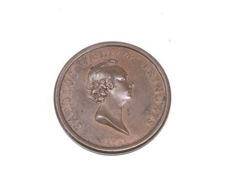
Lot 424
Rare George 11 Arrival of the young pretender expected 1745 Maker: T Pingo.Obverse: Bust of Prince Charles facing right hair short, curly behind, no drapery.Leg. CAROLUS. WALLIAE. PRINCEPS. Below, 1745.Reverse: Britannia, standing by rock on the seashore and resting upon her spear and shield, awaits the arrival of an approaching fleet. Behind her is a globe with the map Great Britain. weight 35g measures approx 42mm dia


-
109198 item(s)/page