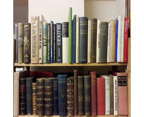

Stuart (Robert) . A Descriptive History of the Steam Engine, 1984, printed for Knight and Lacey, e47 black & white plates, minor spotting, contemporary gilt decorated plum half morocco, boards & spine slightly rubbed, 8vo, together with Clinton (G. Gilroy ) , The History of Silk, Cotton, Linen, Wool, and other fibrous substances;..., 1845, New York, 9 black & white plates,some light toning & spotting, rebound retaining original gilt decorated black cloth boards & spine, slightly rubbed with minor loss, 8vo, and Brooks (C. P.) , Cotton its uses, varieties, fibre structure, cultivation,..., 1st U.K. edition, 1898, 174 black & white illustrations, folding map to pp 112, advertisements to the rear, contemporary inscription to front paste down, minor marginal toning, original gilt decorated green cloth, boards & spine slightly faded & marked, 8vo, plus other 19th century & modern engineering & industry reference, some leather bindings, mostly original cloth, some in dust jackets, G/VG, 8vo/4to. (Qty: 6 shelves)
We found 109198 price guide item(s) matching your search
There are 109198 lots that match your search criteria. Subscribe now to get instant access to the full price guide service.
Click here to subscribe- List
- Grid
-
109198 item(s)/page
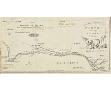
Dalzel (Archibald). The History of Dahomy, an Inland Kingdom of Africa; compiled from Authentic Memoirs; with an Introduction and Notes, 1st edition, London: Printed for the Author by T. Spilsbury & Son, 1793, folding engraved map frontispiece (short closed tear and fraying to fore-edge margin), 6 engraved plates, title inscribed 'William Shaw from his friend George Dalzel Dec. 1833' and 'Given to John Archibald Shaw by his Uncle William Shaw, June 1859', C2 torn across lower outer blank corner, O2 with long horizontal closed tear repaired with transparent paper tape, occasional light dampstains, near contemporary half calf gilt, some wear to head & foot of spine and extremities, 4to (Qty: 1)Together with a small selection of mid/late 19th century carte de viste photographs and genealogical notes relating to the Dalzel Dickson and Shaw family etc.

Sonnini de Manoncourt (Charles-Nicolas-Sigisbert). Voyage en Grèce et en Turquie, fait par ordre de Louis XVI, et avec l'autorisation de la court ottomane, collection de planches [only: without the 2 octavo text-volumes], 1st edition, Paris: F. Buisson, 1801, large engraved folding map hand-coloured in outline, opening to 98 x 102 cm, 6 engraved plates (1 folding), map slightly browned in a few panels, short closed tear neatly repaired to inner fold, a little worming to lower margins of plates, modern quarter calf to style, marbled sides, vellum tips, 4to (33.2 x 25 cm) (Qty: 1)Cobham-Jeffery pp. 58.
England & Wales. Lewis (Samuel & Co., publisher), A Map of England & Wales divided into Counties, Parliamentary Divisions & Dioceses, shewing the Principal Roads, Railways, Rivers & Canals and the Seats of the Nobility and Gentry..., circa 1840, together four large engraved sheets with contemporary outline colouring, sectionalised and laid on linen, inset map of the Scilly Isles, calligraphic title, compass rose, table of explanation, list of Dioceses, large engraved vignette of the General Post Office in London and a table showing the distances by sea from port to port, slight offsetting, occasional spotting, some dust and finger soiling, some splits along old folds, each sheet approximately 1030 x 865 mm, book plate of H. R. C. Martin, College of Arms, each sheet bound in contemporary green morocco gilt boards, rebacked but retaining contemporary morocco labels, extremities a little rubbed and worn (Qty: 4)
Wiltshire - Kennet & Avon Canal. Accounts of the Receipts & Expenditure of the Kennet and Avon Canal Company..., General Account of the Kennet and Avon Canal Company, a broken run, 1822-1851, comprising 59 broadside sheets, printed to one side only (including some duplicate sheets), many with manuscript notes to verso and some to recto, some sheets frayed, marked and soiled, folio, together with Swindon, Marlborough & Andover Railway Company , A collection of approximately 25 printed documents relating to the railway including, A Bill for making a Railway from the Great Western Railway at Swindon to the London and South Western Railway at Andover, 1873; An Act for making a railway from the Great Western Railway at Swindon..., 1873; Estimate of Expense, 1873; The Proposed Swindon, Marlborough & Andover Railway Company Preliminary Statement, [1872]; Ordinary Half-Yearly General Meeting of Shareholders..., Report of Statements of Accounts, 1874 & 1879, includes few duplicates, some manuscript annotations & dust-soiling, printed as issued, some folded, plus few others similar including Prospectus for Henley and London Water Works and Navigation Company, [1848], with engraved map by J. Arrowsmith (2 copies of map & 5 of the prosectus), plus general meeting reports for the Great Indian Peninsula Railway Company, a broken run, 1893-1919, and general meeting report for the Indian Midland Railway Company, 1895 & 1910 (Qty: a small carton)
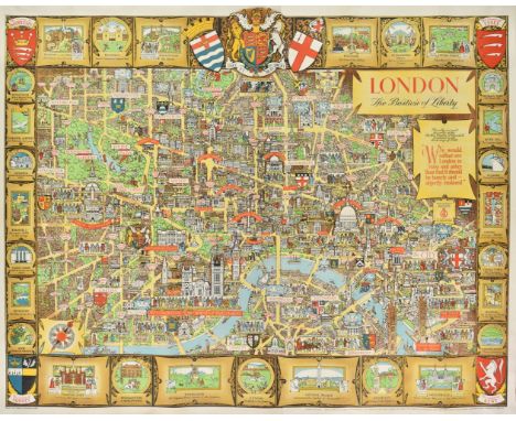
London. Lee (Kerry), London. The Bastion of Liberty, published by The Travel Association of The United Kingdom..., circa 1950, large colour lithograph pictorial map of London, old folds, folds with some wear and cracking, skilfully repaired on verso, backed with archival tissue, 990 x 1230 mm (Qty: 1)A charming portrait of the artist Kerry Lee (1902 - 1988) can be seen in the lower right corner, his name signed on an easel with his faithful dog Jim sitting by his side. Kerry Lee produced two colour pictorial maps for British Railways in the 1930s which were revised up until the 1950s. These railway posters are very much in the style of Macdonald Gill.

Saunders ( Trelawney ). An Atlas of Twelve Maps of India, Edward Stanford, 1889, additional half title, eleven lithographic double page and one folding map (complete), with tables and explanations bound at rear, gutta percha perished with text block broken and disbound, contemporary quarter cloth with gilt title to upper board, worn and stained, upright slim folio (Qty: 1)
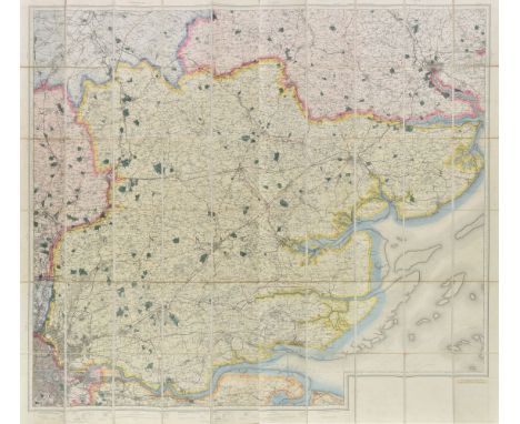
Essex. Untitled Ordnance Survey map, sold by Edward Stanford Ltd. 1914, large engraved map with bright contemporary outline colouring, sectionalised and laid on linen, marbled endpapers, 1440 x 1600 mm, contained in a contemporary red cloth slipcase with manuscript label to upper board and spine, slipcase water stained and faded (Qty: 1)

Europe. Rose (F. W.), Serio-Comic War Map for the Year 1877, published G. W. Bacon & Co., colour lithographic map with explanatory text (in German) pasted over the original English printed text to lower right, slight spotting and staining, old folds, repaired closed tears, extensively repaired and strengthened on verso, 430 x 570 mm (Qty: 1)Rose's map was published in the midst of the Russo-Turkish War. It shows Russia creeping like an octopus across the globe, its tentacles grasping at land and countries on all sides. The European countries are illustrated as individual men and women, partially caricatured, to display their national characteristics, but Russia is depicted as non-human; something alien, malevolent and monstrous, disturbingly prescient in the current volatile socio-political situation of a deliberately destabilising Russian state. This initial representation of Russia as a cartographic cephalopod became a widely used and much copied conceit and this is a scarce German variant of Rose's 'Octopus map'.
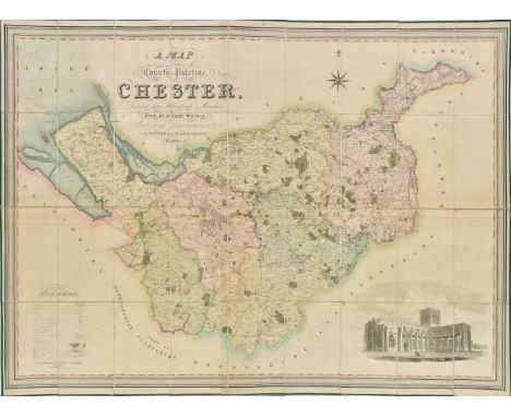
Cheshire. Swire (W. & Hutchings W.F.), A Map of the County Palatine of Chester, Divided into Hundreds & Parishes from an accurate survey, made in the years 1828 & 1829, published Henry Teesdale, 1830, large scale engraved map with contemporary hand colouring, sectionalised and laid on linen, calligraphic title, compass rose, table of reference and an uncoloured vignette of the south west view of Chester cathedral, edged in green silk, marbled endpapers, slight offsetting and spotting,960 x 1320 mm, contained in a modern green cloth slipcase with printed paper label to spine (Qty: 1)
Phillips (John) . Illustrations of the Geology of Yorkshire;..., 2nd edition, 1835, hand coloured county map frontispiece plus approximately 30 hand coloured and black & white plates, ex-library stamp to the title page, some light spotting, contemporary half calf, boards & spine slight rubbed with minor loss to the spine labels, 4to, together with Ansted (David Thomas) , Geology, introductory, descriptive, & practical, 2 volumes, 1844, black & white illustrations, period inscriptions to front paste downs, minor margin toning, uniform original green cloth, boards lightly marked, spines lightly rubbed to head & foot, 8vo, and Geikie (Archibald) , The Ancient Volcanoes of Great Britain, 2 volumes, 1st edition, 1897, numerous black & white illustrations plus maps, loose folding map to front of volume 1, later inscriptions to half-title, some water damage & minor spotting, uniform original green cloth, boards slightly rubbed with some water damage, 8vo, plus other late 19th century & modern geology reference & related, including The Geology and Scenery of the Grampians and The Valley of Strathmore, 2 volumes, by Peter Macnair, 1908, some leather bindings, mostly original cloth, some in dust jackets, G/VG, 8vo/4to. (Qty: 6 shelves)

Nicholson (Cornelius). The Annals of Kendal..., Kendal: Hudson & Nicholson, 1832, engraved frontispiece strengthened at gutter, folding engraved map, few wood engraved illustrations, light spotting & toning, modern cloth, 8vo, together with Kelly's Directory , Westmorland, 1910, folding colour map, adverts at rear, original cloth, 8vo, with Forshaw (Charles F.) , Ten Days in Lakeland, 1892, front pastedown inscribed by the author, original cloth, slim 8vo, with House of Commons Abstract , Abstract of the Answers and Returns..., Intituled, An Act for taking an Account of the Population of Great Britain, and of the Increase or Diminution thereof, Enumeration Abstract, vol. 1 & Parish Register Abstract Vol 3., MDCCCXXXI, published 1833, 17 hand-coloured engraved maps (15 double-page), edges untrimmed, original cloth-backed boards, folio, plus Wainwright (Alfred) , Wainwright in Lakeland, 1st edition, 1983, numerous black & white illustrations, folding map at rear, original mock leather in dust-jacket, oblong 4to (signed edition, number 150 of an unspecified limitation), plus Symons (G.J.) , The Floating Island in Derwentwater, its History & Mystery, with notes of other Dissimilar Islands, [1888], plans and tables, original dark green cloth gilt, slim 4to, and Loftie (Athur Gershom) , Great Salkeld; its Rectors and History, 1900, original cloth, small 8vo, and Curwen (John F.) , The Castles and Fortified Towers of Cumberland, Westmorland, and Lancashire North of the Sands, together with a brief Historical Account of Border Warfare, Cumberland & Westmorland Antiquarian and Archaeological Society, Extra Series vol. 13, Kendal, 1913, numerous black & white plates and plans (few folding), edges rough trimmed, front hinge torn, original cloth, waterstained, 8vo, plus other Cumbria topography and history related, including works by Canon Rawnsley, John Curwen, Miss M.L. Armitt and the C.W.A.A.S. etc., mostly 20th century publications (Qty: approx. 80)
![Balkans. Fries (Lorenz), Tabula V Europae (title on verso), Gaspard Trechsel, Lyons, [1535], uncoloured Ptolemaic woodblock m](https://cdn.globalauctionplatform.com/49399c7a-b2e2-43e7-95f3-aa8800c3db64/33764532-71eb-443d-84e7-aa880137d053/468x382.jpg)
Dutch bindings. M. Annaei Lucani Cordubensis Pharsalia ... curante Francisco Oudendorpio, Leiden: Samuel Luchtmans, 1728, engraved additional title-page, folding map, engravings in the text, leaves r2-3 transposed, contemporary Dutch vellum gilt, ties perished, 4to (25.6 x 19.6 cm), together with: Aristophanis Comoediae undecim, Graece et Latine ... curante Petro Burmanno secundo, Leiden: Samuel and Johannes Luchtmans, 1760, 2 volumes in 1, half-title, title-pages in red and black with engraved vignettes, intermittent spotting, pastedowns renewed, contemporary Dutch vellum gilt, later manuscript spine-title and silk ties, 4to (25.6 x 19.6 cm), and Rituum, qui olim apud Romanos obtinuerunt, succincta explicatio ... a G. H. Nieupoort, editio sexta, Utrecht: Abraham van Paddenburg, 1774, engraved additional title-page, letterpress title in red and black with engraved vignette, 11 engraved plates (10 folding), tide-mark to lower outer corners of text leaves, contemporary Dutch vellum gilt with arms of the Hague, 8vo (20.5 x 12.2 cm) (Qty: 3)

Cook (Captain James). Voyage dans l'Hemisphere Austral et autour du Nonde, fait sur les vaisseaux de Roi, l'Aventure, & la Resolution, en 1771, 1773, 1774 & 1775..., 5 volumes, 1st French edition, Paris, 1778, half titles, 67 engraved maps and plates (numbered 1-65, 10bis, one unnumbered chart in volume V), many folding, two folding tables, folding map no. 2 with reinforcement to verso, a few closed tears, some light spotting and soiling, marginal ink stain to a few leaves and plates towards end of volume II, previous owner inscription 1843 to volume I front endpaper, bookplates, contemporary mottled calf gilt, joints cracking, a little rubbed, 4to (Qty: 5)Sabin 16249.

Thompson (George). Travels and Adventures in Southern Africa, comprising a View of the Present State of the Cape Colony, with Observations on the Progress and Prospects of the British Emigrants, 1st edition, Henry Colburn, 1827, 20 aquatint plates (including one double-page view of Cape Town), folding lithographic map, 2 folding lithographic plans, wood-engraved headpieces, title-page spotted, occasional light spotting to text, marginal spotting to plates, folding map with a couple of splits to folds and small hole to one intersection, early ink-stamps of the Devon and Exeter Institution to versos of title-page and plates, ink inscription '1830, presented by Cap Pruscott' to title-page verso, later half sheep, rubbed, wear to tips, 4to (26.8 x 20.8 cm) (Qty: 1)Mendelssohn II pp. 493-4; cf. Abbey Travel 330 for the second edition of the same year, in octavo. 'This valuable work was written by a Cape Town merchant ... who had travelled throughout the greater part of the Cape Colony and a considerable part of Bechuanaland ... The work contains a number of excellent engravings' (Mendelssohn).
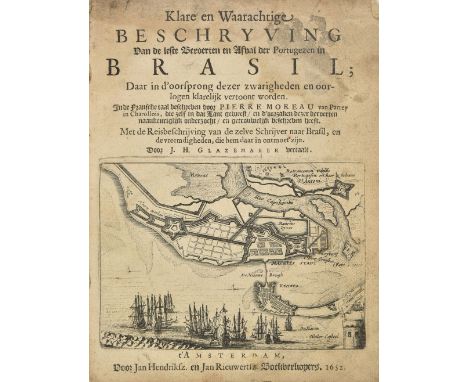
Moreau (Pierre). Klare en Waarachtige Beschryving van de leste beroerten en afval der Portugezen in Brasil, 1st & only edition, Amsterdam, 1652, 94 pp., title with engraved plan, three half-page engravings in text only (of 4, lacking leaf F1), some damp stains and soiling, later marbled wrappers, upper wrapper detached, some wear, 4to, together with An Account of a Voyage to New South Wales, by George Barrington, 1st edition, 1803, engraved portrait frontispiece, engraved title with hand-coloured vignette, folding hand-coloured map, three hand-coloured plates only (of 10), p.23 torn without loss, some light soiling, library label at front, contemporary tree calf gilt, a little rubbed and scuffed, 8vo, plus Geographia Antiqua, by C. Cellarius, editio altera, 1745, title printed in red and black, engraved plate, 26 folding engraved maps, some light toning, bookplate, contemporary calf, rubbed, 8vo (Qty: 3)First work Sabin 50580. Dutch translation of Moreau's Histoire de derniers troubles de Bresil entre les Hollandois et les Portugais, 1651, giving a clear account of the Dutch-Portuguese wars in Brazil in 1648-49 and describing the social life in Pernambuco.

Yorkshire. Bowen (Emanuel), An Accurate Map of the West Riding of York Shire..., An Accurate Map of the North Riding of Yorkshire..., [and] An Accurate Map of the East Riding of Yorkshire..., published C & J Bowles and Robt. Sayer, circa 1777, together three engraved maps with contemporary outline colouring, each sectionalised and laid on linen, each with ink library stamps and a large red crayon number to the upper left corner, each approximately 540 x 720 mm (Qty: 3)All originally published in E. Bowen & T. Kitchin's 'Large English Atlas'.
Simpson (Samuel). The Agreeable Historian or the Compleat English Traveller..., printed for R. Walker, 1746, title page and three maps (only) of The West Riding of Yorkshire, The East Riding of Yorkshire and The North Riding of Yorkshire, maps with old folds and slightly toned, pages 1099 - 1161, disbound, small 8vo, together with Mogg Edward, Paterson's Roads; being an entirely original and accurate description of all the direct and principal cross roads in England and Wales, 18th edition, 1826, frontispiece of an uncoloured engraved map of England & Wales, with an additional nine engraved folding regional maps, appendix bound at rear, bookplate of Jonathan Parsons, text block disbound, 'envelope style' diced calf, boards detached, 8vo, with Paterson (Daniel), A new and accurate description of all the direct and principal cross roads in England and Wales, 11th edition, printed for T. N. Longman, 1796, double page engraved map of England & Wales, small ink stain to right hand margin, title page and table of roads, index bound at rear, near contemporary manuscript annotations to front endpaper, contemporary calf, small 8vo, plus Mogg (Edward), A new map of England and Wales describing all the direct & principal cross roads, boroughs, market towns & villages..., 1821, folding engraved map with contemporary hand colouring, sectionalised and laid on linen, 540 x 450 mm, and Bacon (G. W. publishers), Touring Map of England and Wales, circa 1910, nine colour printed regional maps, folding and laid on linen, with cloth boards, contained in a contemporary calf carrying case, each map approximately, 535 x 720 mm, with two others similar (Qty: 7)
![Tyacke (Mrs R[ichard ] H[umphrey ]). How I Shot My Bears: or, Two Years' Tent Life in Kullu and Lahoul, 1st edition, Sampson](https://cdn.globalauctionplatform.com/49399c7a-b2e2-43e7-95f3-aa8800c3db64/257d5563-7823-4080-a2d6-aa880137c094/468x382.jpg)
Tyacke (Mrs R[ichard ] H[umphrey ]). How I Shot My Bears: or, Two Years' Tent Life in Kullu and Lahoul, 1st edition, Sampson Low, Marston & Company, 1893, folding lithographic colour map as frontispiece, text illustrations from photographs, 32 pp. publisher's catalogue dated 1892 to rear, occasional light spotting, original maroon pictorial cloth gilt, spine sunned and very slightly rolled, pale marks to rear board, 8vo (Qty: 1)Uncommon account of Himalayan big-game hunting by a woman traveller.
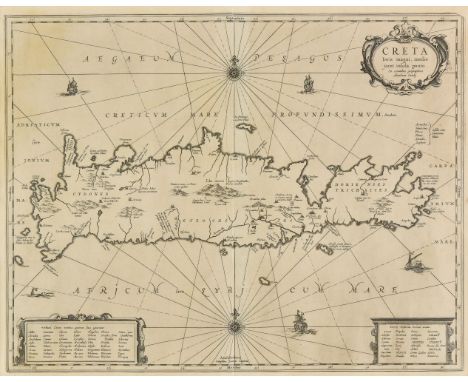
* Crete. Jansson (Jan), Creta Iovis Magni Medio jacet Insula ponto ex conatibus geographicic Abrahami Ortely, circa 1650, uncoloured engraved map, strapwork cartouche, compass rose and numerous rhumb lines, 375 x 480 mm, 375 x 480 mm, mounted, framed and glazed, together with Coronelli (Vicenzo Maria). Napoli Di Romania assediato e presso dall’Armi alla Serenissima Republica di Venezia, sotto il comando dell'Eccellenza del Cap: Gen: Francesco Morosini Cavelier e Procur: di S. Marco 20 ag: 1686, published Venice, 1686, engraved map with contemporary hand colouring, large ribbon and floriate cartouche, 450 x 600 mm, mounted, framed and glazed (Qty: 2)
Badeslade (Thomas & Toms W. H.). Chrographia Britanniae, or a set of Maps of all the counties in England and Wales..., 1742, double page title trimmed with slight loss, 4 general maps, 3 tables , 15 (only) double page engraved county maps, 3 tables bound at rear, some maps split, occasional near contemporary annotations to map versos, several loose, contemporary calf, worn, lacking front board, 8vo, together with: Camden (William). Camden's Britannia Abridg'd, volume 2 (only), printed by J. B. for Joseph Wild, 1701, portrait frontispiece, 10 (only) uncoloured engraved maps by John Seller, contemporary panelled calf, worn, front board detached, 8vo, Cary (John). [Cary's Traveller's Companion..., 1792 or later], lacking title page, advertisement and contents list, 43 engraved maps, index at rear, contemporary mottled calf, boards detached, worn and rubbed, 8vo, Bowen (Emanuel & Owen John). [Britannia Depicta or Ogilby Improv'd...' 1720 or later], lacking title and preliminaries, 28 leaves (only) of uncoloured engraved strip road maps, printed back to back, disbound, contemporary mottled calf, crudely rebacked, worn, 8vo, Salmon (Thomas). Lo stato presente di tutti i paesi, e popoli del mondo naturale, politico, e morale, volume 12 (only), Venice, Giambatista Albrizzi, 1743, allegorical engraved frontispiece, title, folding map of The British Isles with long closed tear, folding map of England and Wales with long repaired closed tear and staining, 27 engraved folding plates, annotations to endpapers, near-contemporary mottled half calf, 8vo, Dower (J.). A Short Atlas of Modern Geography for the use of Schools and Self Instruction , new edition, W. S. Orr & Co., c.1840, calligraphic title, 12 double page engraved maps with contemporary outline colouring, staining, browning and ink marks, near-contemporary ownership inscriptions and annotations, hinges cracked, contemporary half calf, marbled boards, worn and marked, slim 8vo (Qty: 6)Sold as a collection of maps and prints, not subject to return
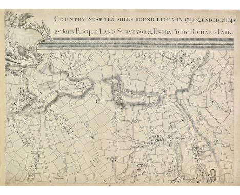
London. Rocque (John), [An Exact Survey of the citys of London Westminster ye Borough of Southwark and the Country near ten miles round, begun in 1741 & ended in 1745 by John Rocque Land Surveyor ; & Engrav'd by Richard Parr.], circa 1746, four (only) uncoloured engraved map sheets from Rocque's multi sheet large scale map of London, some marginal fraying and dust soiling, each sheet approximately 480 x 650 mm, together with two (only) uncoloured lithographic map sheets from Edward Weller's multi sheet large scale map of London, old folds, each sheet approximately 470 x 640 mm, with an unattributed uncoloured engraving ' The South Prospect of the Royal Chapel of St. George in Windsor Castle' l ate 18th century, 460 x 570 mm (Qty: 7)

England & Wales. The New Pictorial Map of England and Wales, published Geographia Limited. circa 1935, pictorial colour lithographic map, old folds, 730 x 485 mm, bound in publisher's colour printed card wrappers, slight staining to rear board, together with another copy but slightly later edition, this example bound in publisher's pink and black printed card wrappers, with Liverpool. Parry (G. H. & Preston A.) , A Map of Merseyside with Historical & Literary Allusions, published Philip Son & Nephew, 1934, pictorial colour lithographic map, old folds, 490 x 730 mm, bound in publisher's colour printed card wrappers, some dust soiling to boards (Qty: 3)

Africa. Danet (Guillaume), L'Afrique dressée sur les relations et nouvelles decouvertes de differens voyageurs..., published Paris, 1732, engraved map with contemporary outline colouring, the four borders decorated with the crests of various countries, some fraying and closed tears to margins, some additional juvenile colouring to the cartouche , slight staining, 490 x 710 mm (Qty: 1)


Wright (Edward). Some Observations made in Travelling through France, Italy, etc. in the Years 1720, 1721, 1722, 2 volumes in 1, 1st edition, for Tho. Ward and E. Wicksteed, 1730, 41 engraved plates, most folding and signed Van der Gucht, 1 woodcut plate, contemporary panelled calf, rubbed, label perished, joints partially split, wear to extremites, 4to (25 x 19.2 cm), together with: Boswell (James), An Account of Corsica, the Journal of a Tour to that Island, 2nd edition, for Edward and Charles Dilly, 1768, half-title, engraved vignette to title-page, engraved folding map (short closed tear affecting frame only), contemporary ink annotations to half-title, p. v and rear blank, contemporary label of Hazard's Circulating Library (Cheap-Street, Bath) to front pastedown, contemporary sprinkled calf, rubbed, headcaps worn, 8vo (20.2 x 12.2 cm), Addison (Joseph), Remarks on Several Parts of Italy, etc., in the Years 1701, 1702, 1703, 1st edition, for Jacob Tonson, 1705, half-title, engraved numismatic vignettes in text, occasional mild spotting, contemporary panelled calf, gilt spine, headcap chipped, front joint split at head, extremities rubbed, 8vo (21.6 x 13.4 cm), Marmontel (Jean-François), The Incas: or, the Destruction of the Empire of Peru, 2 volumes, 1st edition in English, for J. Nourse [and others], 1777, half-title to volume 2, contemporary bookseller's tickets (T. Poole, Chester) to front pastedowns, contemporary tree sheep, headcaps worn, front joints split but firm, 12mo (17.4 x 10.4 cm), Jones (William, editor), The History of the Life of Nader Shah, King of Persia, 1st edition in English, for T. Cadell, 1773, contemporary speckled tan sheep, a little rubbed and worn, 8vo (20.5 x 12.5 cm), and 5 others, 18th- and 19th-century travel, leather-bound, 8vo and 12mo (Qty: 13)ESTC T6300 (Wright), T26158 (Boswell), T74575 (Addison), T120072 (Marmontel), (Jones) T117974; Sabin 44653 (Marmontel).
Hutchinson (William). The History of the County of Cumberland, and some Places Adjacent, from the Earliest Accounts to the Present Time, 2 volumes, Carlisle: Printed by F. Jollie, 1794, engraved frontispieces (one folding) and additional engraved titles to each volume, numerous engraved plates and plans, wood engraved illustrations to text, without folding county map, some toning and minor spotting, fore-edge margins of few leaves a little damp frayed to volume 1, contemporary half calf, morocco title label, volume 1 with slight cracking to joints and worn at head of spine, 4to, together with Hutchinson (William) , An Excursion to the Lakes in Westmorland and Cumberland; with a Tour through Part of the Northern Counties, in the Years 1773 and 1774, London: J. Wilkie, 1776, lacking final leaf (order of plates & errata) and bound without all plates (see Upcott p.120), scattered spotting, bookplate of R.S. Ferguson (Chancellor of Carlisle & President of Cumberland and Westmorland Antiquarian and Archaeological Society), late 19th century half sheep, joints splitting, rubbed and worn, 8vo, with other British topography related including The Beauties of England and Wales, by John Britton, volume 3 only (Cumberland, Derbyshire, & Isle of Man); Guide to all the Watering and Sea-Bathing Places, with a Description of the Lakes..., London: Richard Phillips, [1803]; A Family Tour through the British Empire..., adapted to the Amusement and Instruction of Youth, 2nd edition, by Priscilla Wakefield, 1805, lacking folding plan; Cary's New Itinerary, 1815; The Monthly Magazine and British Register, volume 1, 1796, (with an Account of Coal Mines at Whitehaven & Workington); and The Gentleman's Magazine volumes published 1805-1806 containing the first serialised version of Benjamin Travers' work A Descriptive Tour to the Lakes of Cumberland and Westmorland in the Autumn of 1804 (Qty: 10)
Harris (John). Navigantium atque Itinerantium Bibliotheca: or, a Compleat Collection of Voyages and Travels, 1st edition, for Thomas Bennet, 1705, volume 1 only (of 2), 9 engraved plates including frontispiece (of 23), 6 folding maps by Herman Moll (of 9), frontispiece loose and frayed, double-hemispheric world map browned, other folding maps variably frayed and damp-stained along lower edges, closed tears in Europe map and plate facing p. 392, plate facing p. 405 chipped along fore margin, North Pole map torn at intersection of folds, contemporary calf, lacking rear board, front board detached, folio, together with: Cuthbertson (John). Practical Electricity and Galvanism; containing a Series of Experiments calculated for the Use of those who are Desirous of becoming acquainted with that Branch of Science, 2nd edition ('with corrections and additions'), for J. Callow, 1821, 9 folding engraved plates (plate 2 partially restored in facsimile), possibly lacking half-title, ink-stamps of Siemens Engineering Society, contemporary tan half calf, 8vo, Ozanam (Jacques). Recreations in Mathematics and Natural Philosophy ... translated into English, and improved ... by Charles Hutton, 4 volumes, 1st edition in English, for G. Kearsley, 1803, half-titles, 95 engraved folding plates on 94 sheets (97 plates on 95 sheets called for), contemporary mottled calf, rubbed, volumes 1 and 2 front boards detached, 8vo, Culpeper (Nicholas). Complete Herbal, and English Physician ... to which is annexed the British Florist, Burslem: J. Tregortha, 1813, engraved portrait frontispiece, 33 hand-coloured engraved plates (?of 36: lacking plates 17, 20 and possibly 36), spotting, uncut in original boards, 4to (Qty: 7)Harris: Sabin 30482. The maps in Harris's work include the continents (Europe, Asia, Africa and America), the North Pole, and a double hemispheric world map with California depicted as an island. The lot sold as a collection of plates, not subject to return.

World. Chatelain (Henry Abraham), Mappe-Monde pour connoitre les progrés & les Conquestes les plus Remarquables des Provinces-Unies, Ainsy que celles des Compagnies d'Orient et d'Occident et les Pais quelles possedent dans l'un et dans l'autre Hemisphere, circa 1710, uncoloured engraved hemispheral map of the world, insular California, numbered and annotated text, 340 x 460 mm (Qty: 1)R.W.Shirley. The Mapping of the World, no.447. The text refers to the voyages of discovery by Dutch explorers and the possessions of The Dutch East India Company in Asia.
Elliott (Charles Boileau). Travels in the Three Great Empires of Austria, Russia and Turkey, 2 volumes, 1st edition, Richard Bentley, 1838, tinted lithographic frontispiece to each volume, 2 lithographic maps, 20th-century half morocco, 8vo (21.8 x 13.4 cm), together with: Light (Henry), Travels in Egypt, Nubia, Holy Land, Mount Libanon, and Cyprus, in the Year 1814, 1st edition, for Rodwell and Martin, 1818, 20 engraved plates including folding frontispiece, map, and folding plate of facsimile inscriptions, damp-staining, contemporary tan calf gilt, front board detached, water-damaged, 4to (26.1 x 20.2 cm), Cesnola (Louis Palma di), Cyprus: its Ancient Cities, Tombs, and Temples, 3rd edition, New York: Harper and Brothers, 1878, frontispiece, 2 maps, 61 lithographic plates numbered 1-47 and 1-12 (2 plates unnumbered), top edge original pictorial cloth, spine relined, 8vo (Qty: 4)Abbey Travel 31 (Elliott); Atabey 393 (Elliott); Blackmer 541 (Elliott), 1018 (Light: 'a very interesting work'), 1237 (Cesnola, first edition, 1877); Cobham-Jeffery pp. 34 (Light), 10 (Cesnola, first edition).
![London. Braun (Georg & Frans Hogenberg). Londinum Feracissimi Angliae Regni Metropolis, [1574 or later], engraved map of](https://cdn.globalauctionplatform.com/49399c7a-b2e2-43e7-95f3-aa8800c3db64/499df218-4ab0-45cc-bd22-aa880137e4f8/468x382.jpg)
London. Braun (Georg & Frans Hogenberg). Londinum Feracissimi Angliae Regni Metropolis, [1574 or later], engraved map of London, with contemporary hand colouring, heavily oxidised, slight staining, occasional marginal repaired closed tears, 335 x 485 mm, German text on verso (Qty: 1)James Howgego. Printed Maps of London, no.2 state 2
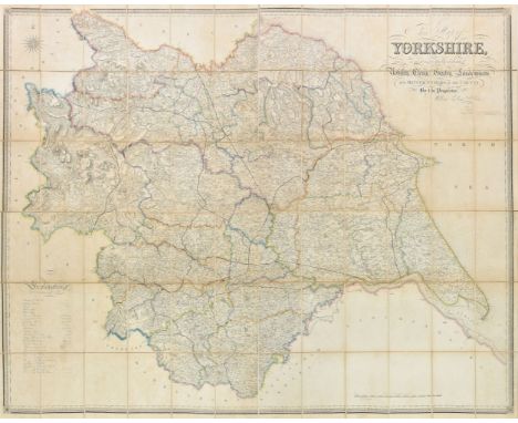
Yorkshire. Hobson (William Colling), This Map of Yorkshire is most respectfully dedicated to the nobility, clergy, gentry, landowners and manufacturers of the county, published J. Wyld, 1845, large scale map engraved by J & C Walker, contemporary outline colouring, sectionalised and laid on linen, calligraphic title, compass rose and table of explanation, slight staining, sparse ink marginalia and scale annotation under mileage scale, 1250 x 1580 mm, marbled endpapers, contained in a contemporary card slipcase with printed paper label to upper cover, slipcase split along base and worn and frayed (Qty: 1)
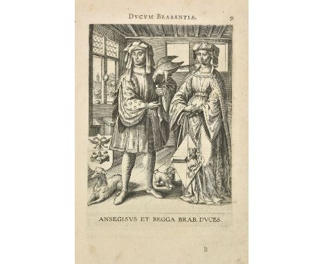
Barlandus (Hadrianus). Ducum Brabantiae Chronica, Antwerp: Ioannem Moretum, 1600, engraved printer's device to title and full-page engraved armorial to verso (repaired closed tear at foot), double-page engraved map and 36 full-page portraits of the Dukes of Brabant, decorative initials and tail-pieces, some light dust-soiling mostly to first & last few leaves, occasional ink marks and very small ink burn holes to few leaves, bookplates of Frederic Pyndar Lowe and John W. Trist to front endpapers and with ownership annotations, 18th century vellum, dust-soiled, folio (Qty: 1)Adams B210.


![[BOOKS]. TOPOGRAPHY, DEVONSHIRE Kelly's Directory of Devonshire, 1897, crimson cloth, quarto (spine faded and damp spottd; l](https://cdn.globalauctionplatform.com/46c7d664-3284-499d-952e-aa8500fa8e44/fb2bd337-9c21-44b2-99f2-aa8b011a8840/468x382.jpg)


CHARLES SMITH (fl. 1800-1852) 'A NEW MAP OF THE COUNTY OF WORCESTER' divided into hundreds, dated January 6th 1804, unframed, the sheet 50cm x 62cm; Two County maps after Cary from the New British Atlas: Essex' and 'Cambridgeshire'; and a small map of Hertfordshire engraved by Gray and published by Fullarton (4)


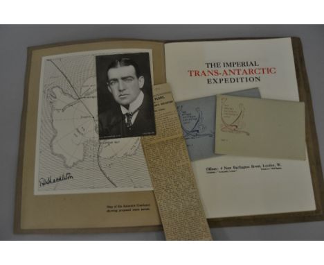
Rare First copy ' The Imperial Trans Antarctic Expedition ' booklet , thirty-one pages including the page mentioning Captain Davis who later declined the post of Captain of ' The Endurance', including a map of The Antarctic Continent, signed by E A Shackleton and the British Antarctic Expedition 1907/9, postcard set 1 and 2 , the postcard in set 1 of Shackleton also signed. This copy presented to Rev. G. Cartwright, vicar of Sydenham at the time. Booklet size 12.25ins x 9.5ins

-
109198 item(s)/page