We found 109182 price guide item(s) matching your search

Refine your search

Year

Filter by Price Range
  • List
  • Grid
  • 109182 item(s)
    /page

Lot 230

A 18th Century map D'Angleterre after Robert 50cm x 60cm

Lot 439

A rolled Ordnance Survey map, Saxmundham and Aldeburgh

Lot 46

Mixed Lot: Two framed maps, the road from Bristol to Worcester, further French coloured map, a further map of the road to Yarmouth and a needlework picture (4)

Lot 768

Georg Braun and Frans Hogenberg, antique hand coloured map, 'Londinum feracissimi Angliae Regni metropolis', German ink inscription verso, 51 x 36cm

Lot 468

African Travel. Railways interest. The Story of the Cape to Cairo Railway & River Route from 1887 to 1922. London: The Pioneer Publishing Co. Volumes 1-4, lacks the map portfolio. Original half-leather. Volumes 2, 3, and 4 are ex-library. (4)

Lot 416

Signed copy. Wainwright, A. - Wainwright in Lakeland. Kendal: The Governors of Abbot Hall Art Gallery, 1983. One of the 1,000 copies signed by Wainwright in green ink to the head of the front end paper. With the original 'order form' loosely inserted. With the folding map in the pocket at rear. In the dust-jacket. A 'Fine' copy. (1)

Lot 401

Local History. Nicolson, Joseph & Burn, Richard - The History and Antiquities of Westmorland and Cumberland. EP Publishing Limited, 1976. Two volumes. In the dust jackets. Both volumes with a folding map. (2)

Lot 423

Travel. Livingstone, David - Missionary Travels and Researches in South Africa. London: John Murray, 1899, 'new edition'. Illustrated including map at rear. Original cloth. (1)

Lot 411

Irish. Lang, R. T. (ed.) - Cyclists' Touring Club. Irish Road Book (part 2 - North). London: E. R. Shipton, 1900. Original green cloth. With the folding map in pocket. (1)

Lot 429

Travel. Australia. Calvert, Albert F. - My Fourth Tour in Western Australia. London: William Heinemann, 1897. Illustrated, including map. Original binding, some wear and soiling. Clean within. With; Withers, William Bramwell - The History of Ballarat, from the First Pastoral Settlement to the Present Time. Ballarat: F. W. Niven and Co. 1887. 2nd edition. With facsimile folding plates/panoramas. Original cloth. With; 3 others. (5)

Lot 402

Antiquarian. Mogg, Edward - Paterson's Roads; &c. London: 1826. 18th edition. Lacking the general map. With 8 plates of maps (1 bound in text, the others bound at rear). Contemporary leather, boards and spine all but detatched. (1)

Lot 519

Folding Map. Survey Department, Egypt. Cairo and Environs (tourist series). Scale 1:75000 or 1-2 miles to 1 inch. Dated 1912. Linen backed. Printed in colour. With; a loose folding map of Milan. (2)

Lot 119

*Lake District interest - After Judy Boyes (20th Century, British), a coloured print, 'Betty Cottage, Troutbeck', signed to the margin, a limited edition 318/850, framed, mounted, and under glass, 26.5cm x 39.5cm, & 48cm x 59cm overall, together with a coloured print of a map of Troutbeck, with illustrated border

Lot 90

A printed map of the Lake District and Cumbria, framed and under glass, 67cm x 97cm overall

Lot 120

*Lake District interest - Two contemporary poster prints, to comprise 'A Fells of The Lake District' design and 'Breweries of Cumbria' tube map style design, both framed, mounted, and under glass, the largest measures 49cm x 66cm overall

Lot 248

1863 book ~ Time tables of the London and South Western Railway and Steam Packets ~ some map edges ragged and part rebound spine

Lot 397

Framed Map of Durham, Harlequin Rugby match programmes, miniature cricket bat, etc (qty)

Lot 214

A collection of antique maps, comprising 'Western part of the Roman Empire', 47 by 40cm, glazed and framed, 60 by 54cm, 'A Map of Britain according to the Notitia Imperii', hand coloured, 24.5 by 25cm, glazed and framed, 32 by 40cm, 'Eastern part of the Roman Empire', 43 by 41cm, glazed and framed, 'Northamptonshire' by H. Moll, 32 by 20cm, glazed and framed, 49 by 38cm, 'Huntingdonshire' by H. Moll, 20 by 32cm, glazed and framed, 51 by 37cm, 'Huntingdonshire' by Robert Morden, 37 by 43cm, glazed and framed, 59 by 53cm, 'Rutlandshire', 1830 engraving, hand coloured, 36 by 45.5, mounted but unframed, 49 by 59cm, and a map of 'Britannia Romana', 42.5 by 36cm, mounted, glazed, and framed, 59 by 54cm. (8)

Lot 215

A group of five 19th century framed maps, comprising a map of Leicestershire by S. Hall, 19.5 by 26cm, framed and glazed, 33 by 38cm; Cornwall by Moule, 21 by 26.5cm, framed and glazed, 32.5 by 39cm; Monmouthshire by Moule, 26.5 by 20cm, framed and glazed, 41.5 by 34.7cm; Leicestershire by Moule, 26.5 by 20cm, framed and glazed, 39.5 by 33cm; together with a map of Northamptonshire by Moule, 26.5 by 20cm, framed and glazed, 40 by 33cm, all hand coloured. (5)

Lot 95

A collection of Ruddles Brewery related items comprising of an illustrated map of Rutlandshire framed print, 46 by 63cm, a Ruddles Brewery sign proof in frame, 29 by 34.5cm, a handwritten letter from Mr Denis Thatcher dated May 1983 on number 10 Downing Street letter headed paper, 21 by 15cm, and accomoanying photograph of a visit he and Margaret Thatcher made to Ruddles brewery, 15 by 20cm. (4)

Lot 172

Jodocus Hondius, an early 17th century, later hand coloured double sided ,map ' The Kingdome of Great Britaine and Ireland' Published 1610, 39 x 52cm

Lot 1034

Michelin Motoring Map of Britain printed to tin sheet, 23" x 32", F-P (Est. plus 24% premium inc. VAT)

Lot 1939

A vintage R.A.C. Wall map, COLLECT ONLY.

Lot 150

This 18th century Ottoman astrological map is signed by Mohamed Hamed Jezdi. The map is etched in copper which is placed on a wooden surface. It had two arrows that can be moved to indicate a specific direction.The map is 17,5 by 13 cm, for its age it is in reasonably good condition, though it has obvious signs of use.

Lot 124

A World War Two German map of Salford Manchester dated 1940.

Lot 201

A British military death plaque / death penny named and issued to "Sidney Thomas Stiles" together with a World War One cloth mounted trench map.

Lot 266

A small group of mixed military collectables to include a British World War Two Pilots note book together with a World War Two silk escape map and World War One full size British war medal named and issued to No.T4-140433 DVR. E. DREWETT of the A.S.C.

Lot 343

A British military camouflage map case together with a tunnel map of Gibraltar.

Lot 128

Robert Morden - coloured map of Warwickshire with a similar of Worcestershire glazed and framed

Lot 339

A Victorian mahogany boxed wooden jigsaw of a world map, retailed by WH Cremer Jnr. The European Toy Warehouse Regent St. London 

Lot 29

Robert Morden (British,1650-1703) 'Suffolk', handcoloured engraved map, circa 1695, 41x43cm, framed and glazed.

Lot 758

ÆŸ&nbspEbers (Georges) L'Egypte: Alexandrie et Le Caire, second edition, map, wood-engraved illustrations, contemporary red half Morocco, Paris, 1883; and a small quantity of others on Egypt, including a 2-volume 1992 reprint of Creswell's The Mosques of Egypt, 2 vol., v.s. (sm. Qty)  

Lot 21

Emma Elena Mihai‘Ambition of Bristol’Acrylic paint on a hollow fibreglass statueMeasures: 229 x 50 x 209cmApprox weight: 57kgAmbition of Bristol sculpture represents a map of Bristol highlighting the main cultural places in the city where all the unicorn sculptures can be found. A very abstract artictic composition that summaries the lively character of the place, a city that is rich in the artictic lifestyle, architecture and greenery.The unicorn which was designed and painted by Emma Elena Mihai has stood proudly at the front gate of Bristol Cathedral all summer, overlooking college green. It has now returned, is in tip-top condition and is finished in an anti-graffiti lacquer. UK Delivery Charges by postcode can be found here: unicorndelivery.tiiny.site

Lot 153

Schmied (Francois-Louis) Original drawing of the map for Homer's Odyssey, gouache over pencil, heightened with gold and silver, on cream wove paper, total sheet 290 x 470 mm (11 1/2 x 18 1/2 in), old folds, [circa 1930s]; together with 3 original designs for historiated initials on vellum-like paper, gouache, each 290 x 240 mm (11 1/2 x 9 1/2 in), unframed, [circa 1930s] (4)
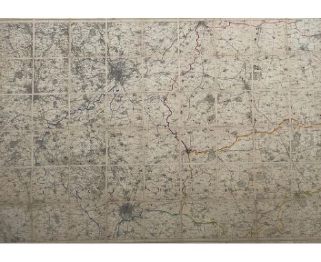
Lot 182

JOAN BLAEU (1596-16732), Map of Russia, with inset vignette of Moscow coloured engraving, 43cm x 54cm, later gilt frame, with Magna Gallery, Oxford label verso

Lot 140

A 17thC Christopher Saxton coloured map 'Svffolclae' incorporating a title cartouche, compass and scale  10.5" x 14.5"  framed

Lot 118

Ordnance Survey map dated 1904 of Seaton, Camerton and Stainburn areas featuring The Cleator and Workington railway line and The Cockermouth and Workington railway line, 135 cm x 103 cm

Lot 397

Five flight vintage map or documents chest

Lot 378

[MAP]. CORNWALL Morden, Robert (English, c.1650-1703), 'Corn Wall', engraved county map, hand-coloured, 37.5cm x 45cm, framed and glazed. Condition Report : Generally good condition; fresh colours; no obvious tears, repairs or browning; light lower edge staining, notably in corners; appears to have been laid-down. Condition reports are offered as a guide only and we highly recommend inspecting (where possible) any lot to satisfy yourself as to its condition.

Lot 1430

A painting of a maze on silk signed by Jill '15 together with a map showing entry and exit from the maze, 'Stand at the crossroads and look: ask for the ancient paths, ask where the good way is, and walk in it', dimensions overall with frame 82x86cm

Lot 246

Five reproduction hunt maps, two of the Holderness Hunt, 64x80cm and 66x81cm, The Tynedale Hunt, 63x62cm, 'Hunting Map of Staghounds, Foxhounds and Harriers, Blackmore Vale and Southwest of England' x 2, each 64x99cm (5)

Lot 254

A map of the Portman Hunt country with a list of masters from 1858-1892 (1990), framed and glazed

Lot 258

An early 20th century linen backed map of the Blackmore Vale hunt, published by Edward Stanford, 26 & 27 Cockspur St. Charing Cross

Lot 259

A linen backed hunt map of Rutland and Leicestershire, showing Nottingham and Leicester, Ordnance Survey of England (3rd ed.), sheet 125, 126 & 127

Lot 260

Ootacamund Hunt map, linen backed, Malabar & Nilgiri Districts, seasons 1908-11, second edition c.1930, with cloth boards, 123x100cm

Lot 261

Fitzwilliam Hunt map, c.1835, linen backed with marbled covers and slip case, by Edward Stanford 53 Charing Cross, 84x91cm

Lot 262

A 19th century hunt map, showing 20 miles round York, linen backed with marbled boards, slip case, c.1898, by Edward Stanford, Geographer to His Majesty, 12, 13 & 14 Long Acre WC, 136x153cm

Lot 263

A set of linen backed hunt maps by A H Swiss, Devonport, including: 'South Devon hunt map, including a portion of East Cornwall', 66x92cm; 'The Hampshire, East Wiltshire, West Surrey, and West Sussex District', 79x101cm; East Cornwall; The Dorst, Wilts. Somerset, etc; North Devon; The Hampshire; Oxfordshire; Hertfordshire (8)

Lot 264

'Verderer's Map of the Beaufort Hunt', linen backed, 60x75cm

Lot 266

A 19th century hunt map, 'Jackson's Map of the Lord Middleton's Hunt', 69x107cm

Lot 267

A linen backed hunt map, 'Map of the Bramham Moor Hunt' dedicated by permission to George Lane Fox Esquire, by Walter W. Masser, 2 Bishopsgate Street Leeds 1885, 68x89cm

Lot 269

A line backed hunt map of the Bedale Hunt country, by Edward Stanford, Geographer to His Majesty, 12, 13 & 14 Long Acre WC, with marbled ends and Morocco leather cover, 77x80cm

Lot 270

A line backed hunt map of the Zetland Hunt country, by Edward Stanford, Geographer to His Majesty, 12, 13 & 14 Long Acre WC, with marbled ends and Morocco leather cover, 76x58cm

Lot 271

A line backed hunt map of the Puckeridge Hunt country, by Edward Stanford, Geographer to His Majesty, 12, 13 & 14 Long Acre WC, with marbled ends and Morocco leather cover, 73x73cm

Lot 272

A linen backed hunt map of the Quorn Hunt country, by Edward Stanford, Geographer to His Majesty, 12, 13 & 14 Long Acre WC, with red cloth cover, 83x75cm

Lot 273

A linen backed hunt map of the Cottesmore Hunt country, by Edward Stanford, Geographer to His Majesty, 12, 13 & 14 Long Acre WC, with marbled ends and red cloth cover, 55x92cm

Lot 274

A linen backed hunt map of the Grafton Hunt country, by Edward Stanford, Geographer to His Majesty, 12, 13 & 14 Long Acre WC, with marbled ends and red cloth cover, 72x78cm

Lot 275

A linen backed hunt map of the Crawley & Horsham Hunt country, by Edward Stanford, Geographer to His Majesty, 12, 13 & 14 Long Acre WC, with red cloth cover, 75x63cm

Lot 276

A linen backed hunt map of the Whaddon Chase country, by Edward Stanford, Geographer to His Majesty, 12, 13 & 14 Long Acre WC, with red cloth cover, 69x55cm

Lot 277

A linen backed hunt map of the York and Ainsty (South) hunt country, by Edward Stanford, Geographer to His Majesty, 12, 13 & 14 Long Acre WC, with red cloth cover, 112x86cm

Loading...Loading...
  • 109182 item(s)
    /page

Recently Viewed Lots