

Seefahrt - - Robert Methven. The Log of a Merchant Officer, viewed with Reference to the Education of Young Officers and the Youth of the Merchant Service. With an editorial Preface by Dr. Lyon Playfair. Illustrated from Sketches by the Author. Mit 1 lithogr. Karte, 6 chromolithogr. bzw. getönten Tafeln sowie 12 getönten, tls. illustr. Tagebuch-Faksimiles. London, John Weale, 1854. Fol. HLdr. d. Zt. mit goldgepr. Rücken- u. DTitel sowie Rückenverg. (beschabt, bestoßen, untere Gelenke eingerissen). Bibliotheksstempel, Innengelenk angeplatzt, Unterrand mit durchgehendem Wasserfleck, tls. leicht fingerfleckig, etwas gebräunt und stockfleckig, vereinzelt geringe Randläsuren. With 1 lithogr. map, 6 chromolithogr. resp. tinted plates, and 12 tinted, partly illustr. diary facsimiles. Contemp. half leather with spine spine gilt, and gilt stamped title to spine and cover (chafed, bumped, lower hinges teared). - Library stamp, inner honge cracked, lower margin with waterstain throughout, some single minor marginal defects.
We found 109182 price guide item(s) matching your search
There are 109182 lots that match your search criteria. Subscribe now to get instant access to the full price guide service.
Click here to subscribe- List
- Grid
-
109182 item(s)/page

Naturwissenschaften - Astrologie - Medizin - Geographie - - Rufus Festus Avienus. Carmina. Flaviano Myrmeico v. c. suo salutem. Ed. Victor Pisanus. Mit 38 Holzschnitten. Venedig, Antonio de Strata, 25. X. 1488. 115 (von 122) nn. Bl. 19,5 x 14 cm. Späterer flexibler Pergamentband (etwas gebräunt, wenig fleckig). Erste Ausgabe. - GW 3131 - HC 2224 - BMC V, 294 - Pell 1673. - Breitrandiges Exemplar der ersten Ausgabe mit der ersten Sternenkarte in einem Buch gedruckt hier als Planisphere. Dieses eindrucksvolle medizinisch-geographisch und astrologische Kompendium, das von Pisanos ediert wurde, beinhaltet 6 Abhandlungen davon 3 in Erstausgabe. Der Band beinhaltet u.a. die Phaenomena des Aratus, die lateinische Übersetzung von De situ orbis von Periegetres mit dem Kommentar von Germanicus, sowie das Liber Medicinae ein astrologisch-medizinisches Gedicht von Serenus. Neben medizinischen Behandlungen werden dort u.a. auch magische Formeln wie erstmals das abracadabra zur Behandlung des Fiebers beschrieben- - Ohne die Blätter a1(weiß)-a3, p1-2, p7-8(weiß). - Blatt g8 weiß. - Blatt b1 mit Eckausriss und Textverlust. Anfangs lose, einige Blätter stärker gebräunt bzw. wasserrandig, wenige Anstreichungen und alte Annotationen. With 38 woodcuts. First edition copy with wide margins with the first star map in a book printed here as Planisphere. This impressive medical-geographical and astrological compendium edited by Pisanos contains 6 treatises, 3 of which are first editions. The volume contains, among others, the Phaenomena of Aratus, the Latin translation of De situ orbis by Periegetres with the commentary by Germanicus, as well as the Liber Medicinae, an astrological-medical poem by Serenus. In addition to medical treatments, magical formulas such as the abracadabra for the treatment of fever are described there for the first time. - Excluding leaves a1(white)-a3, p1-2, p7-8(white). - Leaf g8 white. - Leaf b1 with corner tear and loss of text. Loose at the beginning, some leaves more browned resp. waterstained, few annotations and old annotations.


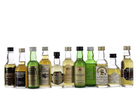
SIXTEEN SINGLE MALT WHISKY MINIATURES Includes Macallan 10 years old (40%), Glenfarclas 10 years old (40%), Glenturret aged 12 years (40%), Lagavulin aged 16 years (43%), Talisker aged 10 years Map label (45.8%), and Tamnavulin aged 12 years (40%). All 5cl miniatures, along with a stemmed nosing glass, two water jugs and Michael Jackson's Malt Whisky Companion. Sixteen miniatures.


The Map Book hardback book edited by Peter Barber. Published 2005 Weidenfeld and Nicolson ISBN 978-0-2978-4372-6. 360 pages. Book in very nice condition. Dust jacket has a 2. 5cm rip at front middle bottom of cover. Sold on behalf of the Michael Sobell Cancer Charity. Shipping at cost from £4.99 in UK, we can ship a 30kg box for £10 so up to 10 books. Overseas shipping at cost from £7.99


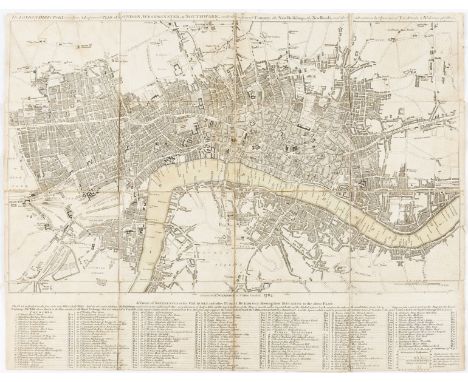
London.- Picture of London (The), for 1819, folding engraved frontispiece and 2 maps, engraved plates of multiple views, contemporary green roan, broken, 1819 § Wilkinson (R., publisher) The London Directory, or a New and Improved Plan of London, Westminster & Southwark..., folding engraved map with faint partial hand-colouring and table at foot, c.410 x 520mm., dissected and mounted on linen, light soiling, folding into old linen slip-case with manuscript label "Plan de Londres", R.Wilkinson, 1784 § Companion to all the Principal Places of Curiosity and Entertainment in and about London and Westminster, ninth edition, without map, advertisement leaf at end, contemporary sheep-backed paste-paper boards, spine gilt, faded, J.Drew, 1799 § Boyle's View of London, and its Environs, spotted, contemporary sheep, name in ink to upper cover, worn, covers detached, [c.1799], all rubbed; and 3 other guides to London including a Picture of London for 1802 without map, 8vo et infra (7)
![Napoleonic Wars.- [Southey (Robert)] A Summary of the Life of Arthur Duke of Wellington ... to his Invasion of France, and th](https://cdn.globalauctionplatform.com/d1e4c605-fa49-49bb-ae32-ad6300d0a697/9b9666dd-92ce-41ef-8271-ad6300fc956f/468x382.jpg)
Napoleonic Wars.- [Southey (Robert)] A Summary of the Life of Arthur Duke of Wellington ... to his Invasion of France, and the Decisive Battle of Waterloo, June 18, 1815, linen-backed folding map frontispiece, abrasion mark to B1 where ?label removed, ex-library with occasional ink- and blind-stamps, occasional spotting and soiling, abrasion mark to front pastedown where label removed, later morocco-backed boards, blind-stamp to upper cover, a little rubbed, Dublin, George Mullens, 1816; and a cast-iron embossed portrait of Wellington, and a defective copy of 'The Battle of Waterloo', 8vo & c.335 x 300 mm (3)
London.- Wakefield (Priscilla) Perambulations in London and its Environs, first edition, folding hand-coloured engraved map, 4 engraved plates, advertisement leaf at end, map lightly browned and repaired at fold, some foxing, modern half calf, Darton & Harvey, 1809 § Ambulator; or, the Stranger's Companion in a Tour round London, third edition, folding engraved map hand-coloured in outline (with short tear to edge), contemporary sheep, worn, for J.Bew, 1787 § Phillips (Sir Richard) A Morning's Walk from London to Kew, first edition, title soiled, near contemporary half calf, spine gilt, rubbed, 1817; and 2 others on London walks, 8vo et infra (5)

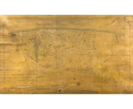
*** Please note, the description of the present lot has been amended.Norfolk.- Hewitt & Capon (Norwich Land Surveyors) Map of the coast from Cromer to Mundesley, large detailed manuscript map, pen and ink with watercolour, numerous details including numbered plots, several sheets conjoined and mounted on linen, presented on wooden roller, total size approx. 1600 x 2000 mm (63 x 78 3/4 in), numerous nicks and tears particularly to extremities, sheet with various handling creases, varnish with some discolouration, rolled, 1866.

London.- Boulton (William B.) The Amusements of Old London, 2 vol., 1901 § Gordon (Charles) Old Time Aldwych, Kingsway, and Neighbourhood, 1903 § Taylor (Tom) Leicester Square..., 1874 § McCarthy (J.) & Joseph Pennell. Charing Cross to St.Paul's, 1891 § O'Donoghue (EG.) Bridewell Hospital: Palace, Prison, Schools..., 2 vol., 1923-29 § Times (The). The History...of the site in Blackfriars..., one of 100 copies on hand-made paper, original cloth-backed boards, dust-jacket (soiled), privately printed, 1956 § Dobie (Rowland) History of the United Parishes of St.Giles-in-the-Fields and St.George Bloomsbury, second edition, folding engraved map in pocket at end (repaired), modern cloth, 1834, plates and illustrations, those in the first hand-coloured, all but the last two original pictorial cloth, gilt, a little rubbed; and c.30 others on central London and the West End, v.s. (c.35)
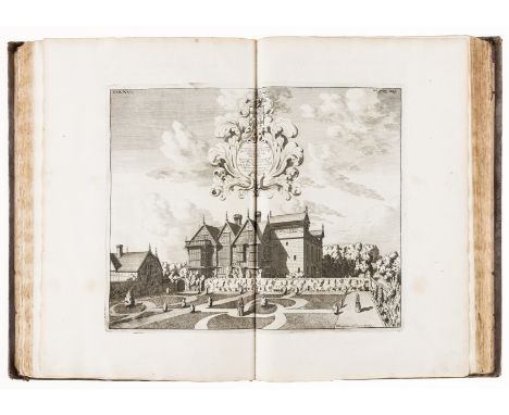
Staffordshire.- Plot (Robert) The Natural History of Stafford-shire, first edition, title with engraved vignette, 37 engraved plates by Burghers, 25 double-page (mostly houses), lacking the "Armes Omitted" plate (as often), also lacking the folding map and 4pp. list of subscribers at end (3M3 & 4), a few contemporary manuscript annotations, plate V torn and stained (loose), plate XV with small rust-hole to image, a few marginal tears and repairs, generally a clean tall copy with wide margins, large engraved bookplate of Rt. Hon. Washington Sewallis Earl Ferrers mounted on front pastedown, lacking front free endpaper, contemporary panelled calf, gilt, spine gilt, rubbed, spine ends and corners worn, joints split, [Wing P2588], Oxford, Printed at the Theater, 1686; sold not subject to return⁂ With two chapters on minerals and stones, including fossils; by the first keeper of the Ashmolean Museum.
![NO RESERVE Asia and Middle East.- Thompson (John) Egypt [with] Abyssinia, from Thompson's 'New General Atlas', engraved map w](https://cdn.globalauctionplatform.com/d1e4c605-fa49-49bb-ae32-ad6300d0a697/5c393e20-fe7e-4a1c-9a66-ad6300fc94e0/468x382.jpg)
NO RESERVE Asia and Middle East.- Thompson (John) Egypt [with] Abyssinia, from Thompson's 'New General Atlas', engraved map with hand-colouring, on wove paper without watermark, sheet 530 x 710 mm (20 7/8 x 28 in), old folds, minor surface toning and dirt, unframed, 1817; together with 3 Henri Chatelain double-page engravings relating to Thailand and South East Asia, all unframed, 18th century (4)
![NO RESERVE Iceland & Greenland.- [Nicol (James)] An historical and descriptive account of Iceland, Greenland, and the Far](https://cdn.globalauctionplatform.com/d1e4c605-fa49-49bb-ae32-ad6300d0a697/ce1f3cd2-7003-4430-9e36-ad6300fc8564/468x382.jpg)
NO RESERVE Iceland & Greenland.- [Nicol (James)] An historical and descriptive account of Iceland, Greenland, and the Faroe Islands; with illustrations of their natural history, first edition, engraved folding frontispiece map of Iceland, additional pictorial title, map of the Faroe Islands, and 2 plates, contemporary calf, gilt, with arms of the Signet library to covers, spine and corners worn, rubbed, Edinburgh, Oliver & Boyd, 1840 § Gaimard (Paul) Voyage en Islande et au Groenland exécuté pendant les années 1835 et 1836 sur la corvette La Recherche, Parts 1 & 2 only (Minéralogie et Géologie), half-title, wood-engraved illustrations, foxing, original printed boards, some staining, lightly soiled, large 8vo, Paris, Arthus Bertrand, 1840; and 3 others, Iceland, v.s. (6)

Iceland.- Henderson (Ebenezer) Iceland, or the journal of a residence in that island during the years 1814 and 1815, 2 vol., first edition, half-titles, engraved folding map and 16 plates, directions to binder f., a few small repairs to map, map and plates foxed, some spotting, water-stained, modern boards, short split to head of spine of vol.1, Edinburgh, For Oliphant, Waugh and Innes, 1818; and Pennant's 'Supplement of the Arctic Zoology', 8vo & small 4to (3)

Iceland.- Troil (Uno von) Letters on Iceland..., made, during a Voyage undertaken in the Year 1772, by Joseph Banks..., first edition in English, engraved folding map, engraved plate of a geyser, lacking initial blank, occasional spotting, lightly browned, 19th century half calf, sympathetically rebacked, 8vo, Printed by and for W. Richardson, 1780.⁂ Troil was chaplain to the King of Sweden, and later became Archbishop of Uppsala. The work was first published in Stockholm, 1777, in German.
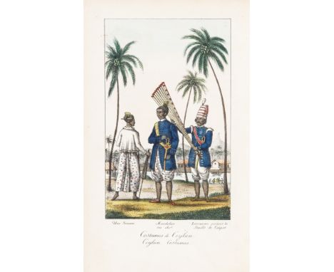
NO RESERVE India to Egypt.- Noé (Louis Panteleon Jules Amedee, Comte de) Mémoires relatifs à l'expédition anglaise partie du Bengale en 1800 pour aller combattre en Égypte l'armée d'Orient, first edition, presentation copy from the author, half-title, 19 hand-coloured lithographed plates, double-page lithographed map with hand-coloured route, errata and binder's ff. at end, lacking folding map of Egypt, spotting and staining, upper hinge split, contemporary red boards, crudely rebacked, head of spine worn and corner worn, upper joint splitting, rubbed, [Abbey, Travel, 350; Blackmer 1204; Colas 2208], 8vo, [Paris], Royal Printers, 1826. sold not subject to return. ⁂ 'The author was a member of the French nobility who emigrated during the Revolution. In 1791 he joined the British Army and served in India. In 1800 this force was sent to Egypt to join in the concerted Anglo-Turkish efforts to oust the French. Most of the plates concern Ceylon and India.' (Blackmer). Provenance: William Arbuthnot (engraved armorial bookplate, with an inscription from the author above it, written in Paris, July, 1826).
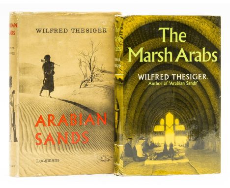
Middle East.- Thesiger (Wilfred) Arabian Sands, folding map in pocket at rear, jacket price-clipped, spine ends and corners rubbed and creased, small patch of abrasion to upper panel retouched by hand, extremities rubbed, light surface soiling to lower panel, 1959; The Marsh Arabs, jacket with very light sunning to spine, rubbing to spine ends and corners, 1964, first editions, plates, original cloth, dust-jackets, very good or excellent overall, 8vo (2)

NO RESERVE Britain.- Anglesey.- Rowlands (Henry) Mona antiqua restaurata. An archæological discourse on the antiquities, natural and historical, of the isle of Anglesey, the antient seat of the British druids, title in red and black, list of subscribers, 10 engraved plates, occasional ink or pencil marginalia, lacking half-title, engraved folding map of Anglesey by John Speed tipped-in at beginning (trimmed to border and with small piece missing from upper left corner), occasional spotting, lightly browned, contemporary calf, gilt spine in compartments and with red morocco label, upper joint split, but holding firm, spine ends and corners worn, rubbed, Dublin, printed by Aaron Rhames, for Robert Owen, 1723; and and another, Berkshire, v.s. (2)

Wiltshire.- Speed (John) Wilshire, first edition, county map with inset town plan of Salisbury and a vignette of Stonehenge, engraving with hand-colouring, on laid paper with armorial watermark, sheet 393 x 514 mm (15 1/2 x 20 1/4 in), first edition woodcut initial verso, double-glazed, central vertical fold with splitting repaired, carefully repaired tear centre left, minor toning, Sudbury and Humble, framed, [circa 1610-1612].


William (Bill) Thomas - 'Ashmore, Dorset', signed with the artist's monogram also inscribed with the title verso, oil on board, 18" x 18" together with six further oil paintings by the same artist, (various sizes) they are sold together with biographical details on the painter and wood carver who exhibited at The Burton Gallery in Wirral with a press cutting from The Arts Guardian Newspaper dated November 1st 1969 also an oil painting by Ivan Lindsay of an industrial river scene, and a coloured reproduction after Jorge Aguilar - Agon, an artist's signed proof after Mark Smallman, titled 'Waterway' showing the Avon And Kennet canal and various vignettes depicting Dundas Aqueduct and other locations, also a reproduction map of Somerset published by The Bristol Evening Post in 1972, various sizes (a collection)

H* Remmington (20th century) - landscape with trees in a lane, signed, oil on board 7.25" x 10.25"; together with a further example by the same artist depicting a further landscape, also a lithographic print depicting a mouse dressed in costume with other insects nearby, a lithographic print, an oil painting by G* Noone, landscape scene, a hand coloured engraving by R Creihton depicting a map of Norfolk, a coloured lithographic print after Johannes Franciscus Spohler depicting a Dutch river scene, an oilegraph, also two reproductions depicting brass rubbing scenes after Irene Cowan, one depicting Sir Robert de Burgh originally from a tomb dated 1302, signed artist coloured etching depicting Bromley Parish church interior by Janet Simpson, and a coloured print after Anna Lea Merritt, entitled 'Love Locked Doubt' and a monochrome print depicting the officer's motto for the RAF, the title being 'Per Ardua Ad Astra', various sizes (a collection)

Terence Cooper (20th/21st century) - a map of the world taken from an original work from 1626, pen ink and watercolour, 18.25" x 24.5"; together with two faded prints after Carmen Hohl Peterson, dated 1979 tilted Groot Constantia, Cape South Africa, also a pencil andn watercolour signed John Hall and dated 1975, 'The Last Days of Clifton Street, District Six' also a companion work by John Hall dated 1975, 'Roof Street, District Six', a coloured reproduction of Notre Dame Cathedral beside the river Seine, France, various sizes (5)


After Pieter Casteels, a pair of hand-coloured engravings depicting vases of flowers for April and July inscribed from 'The Collection of Rob. Furber, gardener at Kensington 1730, engraved by H. Fletcher', each 40.5 cm x 30 cm, together with a 17th Century Christopher Saxton map of Denbigh, hand coloured, a Blaeu map of Wales and three further maps, all depicting Welsh regions.Qty: 7


A collection of militaria to include Women's Transport Service F.A.N.Y (First Aid Nursing Yeomanry) badges and buttons, including five various red on khaki embroidered badges, thirteen small buttons, three larger buttons, cross cap badge and four other Victorian buttons, together with clear map satchel, various maps, Bartholemew's maps various, etc


A cased silver dishRoyal Irish Silver Limited, Dublin 1968 With sunray design, engraved on reverse 'one of four replicas originally by Joseph Walker, Dublin 1717' diameter 25.3cm, together with six other modern Irish silver, comprising: a dish, William Egan & Sons, Dublin 1973, fluted rectangular form, engraved with a map of Europe and 'Into Europe', length 20.5cm, a plate, Royal Irish, Dublin 1973, circular etched with a scene of 'St Patricks Cathedral Dublin', diameter 22.8cm, a 'Brandy' label modelled as the Gleninsheen collar, William Egan & Sons, Dublin 1973, a small tumbler cup, Royal Irish, Dublin 1970, a wine taster, Dublin 1988, and a money clip, Dublin 1999, weight 44.5oz. (7)Footnotes:ProvenanceThe first dish, The Kurt Ticher CollectionFor further information on this lot please visit Bonhams.com

-
109182 item(s)/page