We found 109198 price guide item(s) matching your search

Refine your search

Year

Filter by Price Range
  • List
  • Grid
  • 109198 item(s)
    /page

Lot 1001

Frank Albury Beverley (1911-1998). Study in block and line, oil on board, 34cm x 26cm, and other works, Cosmorama, a map of Lincolnshire and two other pictures (5).

Lot 124

V.E. Hayes Riverside House Watercolour signed 24cm x 35cm Another of a winter scene, a map of Wimbledon and prints after Old Masters (6)

Lot 809

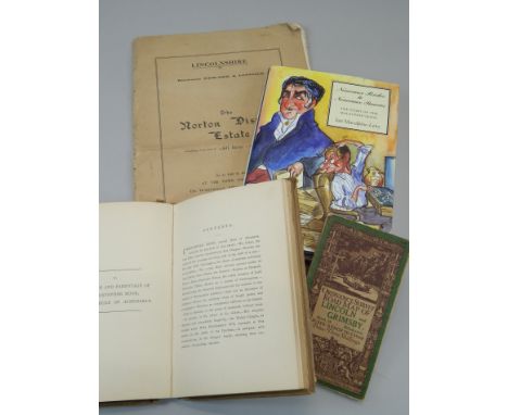
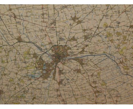
Various books, to include an auction catalogue for the sale of the Norton Disney Estate, a copy of Nouveau Riches to Nouveau Pauvers, written by Ian Macalpine-Leny, signed by the author, ordnance survey map of the road between Lincoln and Grimsby and a book on the parish memorials relating to Norton Disney, published 1893

Lot 919

After Hondius. County map of Lincolnshire, later coloured, 41cm x 53cm.

Lot 954

After Robert Morden. County map of Suffolk, uncoloured, 37cm x 44cm.

Lot 981A

A modern laminated ordnance survey map, depicting the City of Lincoln etc., 90cm x 100cm.

Lot 272

1921 Map of Hexham, jug and bowl etc

Lot 562

Robert Mordon map of Westmorland

Lot 386

Christopher Saxton and William Kipp, 'Caermardi' (Carmarthen), an original sparsely coloured map. Framed and glazed.

Lot 431

Group of assorted furnishing pictures, needlepoints, map, L.S. Lowry montage etc. (5)

Lot 170

Bag of mixed books including a 1914 map of Warrington

Lot 250

History of the British Army by Fortescue, with map books, 14 vols, c.1910, The Life of Wellington by Sir Herbert Maxwell, c,1900, 2 vol.

Lot 523

OLYMPICS, selection, inc. softback editions of Oylmpische Rundschau (7), annual reports of the International Olympic Institute, July 1938-April 1943; German c/c, Olympia 1936 Vols I & II (with map), with duplicates laid down in scrap album; IOC Poster postcards (42), Impel US Olympic Hall of Fame (set of 90) etc., G to EX, 143*

Lot 342

An antique map "Islands of Japan" framed and glazed with certificate, together with a reproduction map

Lot 345

Antique French map of Normandy - 1695 - framed and glazed

Lot 728

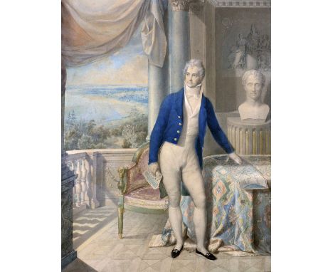
Attributed to John Russell (1745 - 1806)Watercolour: "Sir John Thomas Coghill, 2nd Bart, 1766 - 1817," Full length Portrait, seen in a classical setting, his Louisiana property visible through a large window in the background, and with his left hand resting on a map, approx. 60cms x 46cms (23.5cms x 18") in contemporary ornate gilt frame.Following the Louisiana Purchase of 1803, the US Congress authorised a grant of over 11,000 acres to the Marquis de Lafayette, hero of the American and French Revolutions. Most of this was situated at Pointe Coupée on the Mississippi River, with a small tract near New Orleans. In 1810 Lafayette sold these lands to pay off his debts; half was bought by Henry Seymour and Sir John Coghill, and Coghill also bought the New Orleans section.After Sir John's death in 1817 he was succeeded by his brother, Vice-Admiral Sir Josiah Coghill, who sold the Louisiana estate as he considered it a liability (he had a point: it was devastated by Hurricane Katrina in 2008). (1)

Lot 512

Map of Northamptonshire by Robert Morden

Lot 624

Map drawers & an index card filing cabinet

Lot 483

Victorian embossed metal picture frames, other pictures and prints, Philip's map of the Indian Empire and CeylonProvenance: From the Estate of Stephen Masty

Lot 566

A case of World War II military ordnance survey maps 1941, un-numbered, with index card and other war editions and a trolley bus and tram route map, dated 1947

Lot 384

C19th "Tomblesons" canvas folding map of Thames and Medway, three further maps , two books, autograph with stuck down family rests, and signature, including "Charles Dickens" & a C20th three division stamp holder

Lot 124

STARBURST CIRCULAR WALL MIRROR, TWO OTHER MIRRORS, A WOOLWORK TAPESTRY AND A MAP IN A FRAMED

Lot 147

A LARGE COFFEE TABLE WITH GLASS TOP AND MAP INSET

Lot 376

SUNDRY PICTURES AND PRINTS, A FRAMED REPRODUCTION MAP 'THE COUNTIE PALATINE OF LANCASTER' AND SOUTHERN COMFORT MODERN PUB TYPE MIRROR IN FRAME AND A BOXED 'YE OLDE HALF YARD OF ALE DRINKING GLASS'

Lot 96

Hand tinted map of Cheshire 18th Century 36x49cm, coloured map of the North East circuit of the Princepality of Wales including Flint, Denby and Montgomery, by C & J Greenwood, London 1834, showing you various estates and points of interest, 62x72cm, hand tinted map of Lancashire printed for Carrington Bowles early 19th Century, 25x16cm, further map of Northumberland, 20x16cm, print of Middlesex c.1840, 18x23cm, framed and glazed, glazing on map of Middlesex lacking. (4)

Lot 2138

A quantity of prints including three Etchings in one frame of the Sugar Loaf, Usk and Abergavenny, another of Dublin Castle, Evening on the Sea and a hand coloured Map of Yorkshire.

Lot 2172

A Woolwork picture of 'The Old Mill', 13'' x 18'', a Print of a terrier curled up with a ginger cat and a framed Map of the 'Hundred of Black Heath',15'' x 13''

Lot 10

J OWEN & E BOWEN a coloured and tinted map - 'The Road from London to Holyhead', glazed to the rear, 17 x 12cms

Lot 11

UNKNOWN CARTOGRAPHER coloured and tinted into a scale of 4ins:1mile - A map of Llandudno and environs published by T Williams, Chemist, Llandudno and entered at Stationer's Hall and depicting very interestingly the whole of the Llandudno area from the Great Orme to Pydew and Conwy prior to any development, 31 x 51cms

Lot 16

JOHN SPEED a coloured and tinted map of Carmarthenshire, Bassett and Chiswell edition, mounted but unframed, some overall foxing, 39.5 x 52cms

Lot 17

JAN JANSSON a coloured and tinted map of Cardiganshire, mounted but unframed, 39 x 51.5cms

Lot 176

IWAN BALA mixed media on paper - map of Wales with vegetation and traditional Welsh hat entitled 'Beca', signed and dated 2004, 21 x 16cms

Lot 18

J BLAEU a coloured and tinted map of Wales, mounted but unframed, 40 x 52cms

Lot 19

UNKNOWN CARTOGRAPHER a coloured and tinted map of Montgomeryshire, mounted but unframed, overall foxing, 39 x 51cms

Lot 22

THOMAS KITCHIN a coloured and tinted map of Glamorganshire with a north west view of Cardiff dedicated 'To The Most Noble Duke of Bolton' the then Lord Lt of Glamorgan, mounted but unframed, 35 x 52cms

Lot 24

JOHN SPEED a coloured and tinted map of Anglesey, Bassett and Chiswell edition, 38.5 x 51cms

Lot 26

HUMPHREY LLWYD a good coloured and tinted map of Wales, good margins and glazed to the rear, 46 x 55cms to the margins

Lot 150

A framed map of Scotia Regnum from Gerard Mercator's Tabulae Geographia in a faux maple frame, 72 x 58cm

Lot 102

T E Lawrence - Seven Pillars of Wisom, A Triumph; together with an engraved map of St Lucia; and a sampler type print

Lot 390

First World War silk map, dated 10.12.17. Gouzeaucourt

Lot 5589

1970 Denoyer-Geppert Social Science map depicting the peoples and tribes of Italy 112cm wide x 82cm high

Lot 5706

LESLEY DAVY (b. 1953) A framed and glazed coloured etching - "Map". Pencil signed and numbered 1/1

Lot 148

A framed map of Melrose by Rob Hain. size 49cm x 69cm

Lot 1127

A J. Carey framed Map of Hertfordshire and a Moules English Counties framed Map of Hereford.

Lot 1211

Four framed Prints of maps including an Ordinance Survey map centred on Blackheath Birmingham, Le Royaume D'Angleterre, Hereford and Worcestershire.

Lot 474

A hand coloured map, drawn and engraved by John Andrews, Bedfordshire (52cm x 69cm) glazed in an ebonised frame.

Lot 1279

A large framed Map of Herefordshire by Greenwood & Co together with a hand coloured Map of Shropshire.

Lot 1438

A large Philips' Commercial Map of England and Wales with Southern Scotland showing railways, roads and shipping routes, (Sales Manager's edition) framed with heavy duty plastic glazed front, 82 1/2'' x 61'' overall

Lot 723

LARGE FOLDER WITH PHOTOGRAPHS, PLANS, MAP, CERTIFICATES, SALE CATALOGUE ETC. (19)

Lot 243

Smith's Map of London, Smith's new plan of London, Westminster & Southwark, comprehending all the new buildings and 350 references to the principal streets, with the new docks at Wapping & Blackwall, 41cm x 74cm, 21 panels backed on linen, London: printed for C Smith, Map seller, 172 Corner of Surrey Street, Strand, 1819

Lot 244

19th Century Brookes's England folding map, Brookes Travelling Companion through England and Wales, Published by William Darton and Son, 2nd Edition, 52cm x 58cm

Lot 245

Thomas Kitchin, Asia and it's several Islands and Regions, according to their most approved divisions with Captain Cooks New Discoveries, the hand coloured map circa 1795, 54cm x 45cm

Lot 250

Robert Morden, 18th Century map Norfolk, hand coloured, 56cm x 38cm

Lot 251

Thomas Kitchin (1718-1784) hand coloured map of Cumberland and a hand coloured map of Derbyshire, together with a 17th Century map of Westmorland and a circa 1761 map of Derbyshire, (4)

Lot 253

Mixed maps, to include, John Cary Nottinghamshire, Derbyshire, Alex Hogg North Wales, East Riding and Halley map of the World, (5)

Lot 254

Mixed maps, to include Robert Morden, South Wales, 17th Century map of Lincolnshire, Robert Morden map of Norfolk, Montgomery shire and a Derbyshire Map, (5)

Lot 255

Johann Baptist Homann, Magna Britannia Complectens Angliae Scotiae et Hiberniae, published Nuremberg, circa 1740, engraved map with hand colouring, 58cm x 49cm

Lot 256

James Green, 1819, Map of the turnpike road from Plymouth to Exeter, J Cary Strand, 94cm x 26cm

Lot 258

New York street map, 1840, with City Hall and Broadway printed to the corners, 38cm x 30cm, together with a Philadelphia street map, 37cm x 30cm, (2)

Loading...Loading...
  • 109198 item(s)
    /page

Recently Viewed Lots