We found 109182 price guide item(s) matching your search
There are 109182 lots that match your search criteria. Subscribe now to get instant access to the full price guide service.
Click here to subscribe- List
- Grid
-
109182 item(s)/page


Lot 1434
Portfolie met zeefdrukken - De druppel die de rivier blij maakt- uitgave 1988. Deelnemende kunstenaars : Jantine Geels, Sigrid Hamelink, Harm van Zwol, Alex Thoma, Steven Toes, Anneke Germers en Erik Koenders. Van elke kunstenaar een boekje met zeven zeefdrukken. Tevens een voorwoord-map met nog eens 1 zeefdruk van elke kunstenaar, alles gesigneerd en genummerd. Dit alles samengevat in bijbehorende open cassette. Gedrukt in het Grafisch Atelier Kampen in 1988
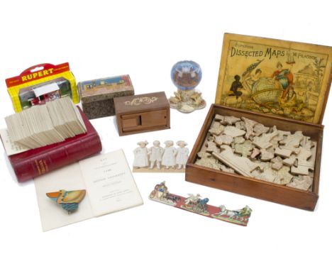
Lot 555
Various puzzles and games, a W. Peacock Superior Dissected Map of Engand & Wales, in original wooden box with sliding lid and instructions (complete); a John Betts Game of British Geography, in original Morocco leather book box; a tinplate click toy of a pelican; a snow globe of Volkenburg; a Japanese wooden dolls' house puzzle block, in original box; a Lledo Rupert the Bear van; and a few scraps

Lot 505
Dissected wooden Puzzles, a map of Ireland with story to reverse; a map of England and Wales, with two wooden boxes (probably incorrect for puzzles); a map of The World on Mercators Projection, designed to stand on edge (damaged and probably missing pieces); and two other puzzles (not checked for completeness) - The Ethel May de Wolf Collection

Lot 228
Christopher Saxton (c.1540-1610) engraved and hand tinted map of Yorkshire in later frame. Formed from two conjoined sheets and trimmed to the border. Inscribed Eboracensis comitatus (cuius Incolae olim Brigantes appellabantur) Longitudine Latitudine hominumque nemero relequis illustrior, Ano Dm 1577, 52cm 72cm. Trimmed as per description. Triangular section missing and coloured in to the lower centre 3cm x 4.5cm. Section in the middle lacking and York coloured in later. Some wear, fold lines and discolouration.


Lot 158
NICHOLAS POCOCK (BRITISH, 1740-1821) To The Memory of Captain George Nicholas Hardinge of the St Fiorenzo Frigate Action with La Piémontaise French Frigate Coloured aquatint 18 x 24in. (46 x 61cm.); together with another coloured aquatint Engagement with the Tay-Ping Rebels at Nanking after Bedwell, a map of 'Indiae Orientalis' and Boardroom of the Admiralty after Rowlandson (4)


![[MAP]. NORTHAMPTONSHIRE Smith, Charles (1768-1854), 'A New Map of the County of Northampton', 1801, engraved map, hand-colou](https://cdn.globalauctionplatform.com/7b20873a-fa6d-426f-b7f6-ac6800d52fcd/aca0570e-5841-4153-a4f6-ac6f010ea47e/468x382.jpg)
![[BOOKS]. HISTORY, SCOTLAND Browne, James. A History of the Highlands and of the Highland Clans, four volumes in eight, Fulla](https://cdn.globalauctionplatform.com/7b20873a-fa6d-426f-b7f6-ac6800d52fcd/d07e01cb-47a5-4b55-a0be-ac6f010ebce3/468x382.jpg)
![[BOOKS]. TOPOGRAPHY, DORSET An Inventory of the Historical Monuments in Dorset, Volume 1: West, Royal Commission on Historic](https://cdn.globalauctionplatform.com/7b20873a-fa6d-426f-b7f6-ac6800d52fcd/cfd1ec28-a611-40a5-b490-ac6f010eb4d5/468x382.jpg)
Lot 26
[BOOKS]. TOPOGRAPHY, DORSET An Inventory of the Historical Monuments in Dorset, Volume 1: West, Royal Commission on Historical Monuments, H.M.S.O., London, 1952, grey cloth, plate and text illustrations, plans, folding map in pocket at end, large quarto; Maxwell, Donald. The Landscape of Thomas Hardy, first edition, Cassell & Co., London, 1928, sand cloth, frontispiece and another eleven colour plate illustrations (as called for), further text illustrations, quarto; and four other works, (6).
![[BOOKS]. TOPOGRAPHY Wakefield, Priscilla. A Family Tour through the British Empire; containing some Account of its Manufactu](https://cdn.globalauctionplatform.com/7b20873a-fa6d-426f-b7f6-ac6800d52fcd/41f7b860-9828-4cab-b6be-ac6f010ea7aa/468x382.jpg)
Lot 14
[BOOKS]. TOPOGRAPHY Wakefield, Priscilla. A Family Tour through the British Empire; containing some Account of its Manufactures, Natural and Artificial Curiosities, History and Antiquities... particularly adapted to the Amusement and Instruction of Youth, eleventh edition, for Harvey & Darton, London, 1823, half calf, folding hand-coloured engraved map frontispiece, six-page publisher's list, octavo (re-backed; foxed).


Lot 82
Karel Anthony Nel (South African, born 1955)Cosmos inscribed 'Karel Nel/ 2011/ Cosmos: 259 Degree Field' (verso)sprayed pigment on bonded fibre paper55 x 210cm (21 5/8 x 82 11/16in).Footnotes:ProvenancePurchased at Art First, 2011.A private collection, UK.In 2004, Karel Nel was appointed as the resident artist on COSMOS - an ambitious project to map a two degree field of the universe. Working alongside a team of astronomers, Nel produced a series of pieces that were informed by the images and data collected from radio, x-ray, infrared and optical telescopes.This piece explores one of Nel's chief preoccupations: the visual and scientific conventions of representing vanishing points. He is fascinated by the way a vanishing point can determine a focal point, sidelining other objects to the periphery.Nel's medium is highly unusual, incorporating pastel, ochre, volcanic glass, sand and dust on a background of bonded fibre fabric. In 2012, Nel participated in the major exhibition African Cosmos, Stellar Arts: African Cultural Astronomy from Antiquity to the Present at the Smithsonian Museum of African Art.Nel's aesthetic fusion of scientific phenomena and artistic abstraction has been described by the South African poet, Stephen Watson, as an intellectual and spiritual investigation:'follow(ing) the trajectory of an inner journey, trawling amidst the rich multiplicity of the world's cultural traditions, their rites and symbols, searching for that imagery which might connect our conscious lives with the deepest spiritual potential within ourselves.' (1994)For further information on this lot please visit Bonhams.com


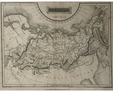
Lot 502
THIS IS A FINE 1826 MAP OF RUSSIA IN ASIA, DRAWN BY J. ASSHETON AND ENGRAVED BY J. SHURY. THIS BEAUTIFULLY DRAWN BLACK AND WHITE MAP COVERS THE ENTIRE AREA OF RUSSIA AND THE ADJACENT PARTS OF THE CHINESE EMPIRE. MAKES NOTE OF NUMEROUS RIVERS, MOUNTAIN RANGES, GULFS, SEAS, AND MAJOR CITIES. SCALE IS SHOWN IN THE UPPER CENTER QUADRANT. PUBLISHED BY THOMAS TEGG OF 73 CHEAPSIDE, LONDON. APP.SIZE:


Lot 334c
The Great Bear by Simon Patterson. Framed and glazed. The Great Bear is a conceptual artwork by the British artist Simon Patterson. It is a copy of the 1991 London Underground map with the names of stations replaced by the names of famous cultural figures. Each Tube line represents a category of 'celebrity', including philosophers, footballers, engineers and comedians. Harry Beck's Tube map and the 'Great Bear' constellation, Ursa Major, are two familiar and easily accessible systems for ordering information. By adapting one and adopting the name of the other, Patterson's playful arrangement of the 'stars' challenges the authority and function of these systems.


Lot 4159
Late Victorian wooden school room setting with bisque head teacher and six German all bisque pupils each seated at a combined desk and chair with slate board, in a classroom furnished with chest of drawers, fire-surround, lectern, wall map, pictures, miniature books, school bell, chalk board on easel, wall clock etc, L70cm H28cm D28cm - Condition Report


-
109182 item(s)/page