We found 109182 price guide item(s) matching your search
There are 109182 lots that match your search criteria. Subscribe now to get instant access to the full price guide service.
Click here to subscribe- List
- Grid
-
109182 item(s)/page
![Summers (Jeremiah William) The History and Antiquities of Sunderland, Bishopwearmouth... Volume I [all published] (Memoir of](https://cdn.globalauctionplatform.com/f3ca7dad-4f9a-42dd-af78-a4a500dc599c/845eeeb9-5a5d-480c-acdc-b7b7c88d9b5e/468x382.jpg)


Lot 350
John Senex (1678-1740) "A MAP OF THE PROVENCE OF HAINAULT, NANUR, AND CAMBRAY" engraving with hand-colouring, published 1710 47.5 x 65cms; 17 3/4 x 25 1/2in. (plate size); William Delisle (French 1675-1726) "THE PROVENCE OF ARTOIS AND THE COUNTY ADJACENT" engraving with hand-colouring, published 1713 49 x 61cms; 19 3/4 x 24in. (plate size); together with two similar maps by William Delisle, unframed. (4)


Lot 355
Robert Morden (c. 1650-1703) MAP OF NOTTINGHAMSHIRE, HEREFORDSHIRE, AND ROTELANDIAE engravings with hand colouring, published 1695 36.5 x 43cms. 14 3/4 x 17in. (average plate size); Richard Blome, (1635-1705) A MAP OF BEDFORDSHIRE engraving with hand colouring, published 1673 36.5 x 43cms. 14 1/4 x 17in. (average plate size), unframed. (5)


Lot 715
An oil painting on board painted with the palette knife technique showing a Sea Link Ferry and signed bottom left M Ridley, inscribed verso Maureen Ridley, 45 x 60 cm, an oil painting on board of a harvesting scene, signed indistinctly bottom right C Green (?), a map of Cumberland after Robert Morland, reproduction 19th century style map of the British Empire, etc

Lot 718
A small black and white etching by Louis Rosenberg, signed in pencil bottom right with label verso Street in Constantinople, 6 cm square approx, an early 19th century map of the United States published 1817 by A Constable of Edinburgh, 22 x 26 cm, a 19th century lithograph of Cook's Folly looking down the Avon, published by O C Lane, two further topographical engravings, all framed, and a Venetian style wall mirror of rectangular form with moulded and faceted glass and gilt metal frame, 46 x 43 cm overall

Lot 742
A pair of black and white engravings of Lake District scenes, signed G E Gascoigne showing Loweswater scenes (in one frame), 20 x 40 cm total together with a mid-18th century map of Leicestershire by F Badaslade, a map of Northumberland by Robert Morden and a map of Middlesex by Emmanuel Bowen, maximum size 26 x 21 cm in black and gilt frames


Lot 460
Christopher Greenwood (1786-1855) and John Greenwood (fl. 1821-1840) - Coloured engraving - "Map of the County of Kent from an Actual Survey made in the years 1819 and 1920" - Depicting vignette of Canterbury Cathedral, 23ins x 27.5ins (slight small tear to right margin and some discolouration), in Hogarth frame and glazed


Lot 432
***PLEASE NOTE: incorrectly illustrated, the image refers to Lot 433*** JOHN SPEEDThe Isle of ManEngraved Map after the original drawing by Tho. Durham,printed for the atlas 'The Theatre of the Empire of Great Britaine'.385 x 510mm (framed)together with ;West Morlandia, after Gerardus MercatorEngraved and partially hand coloured map(Framed) (2)


Lot 451
A COLLECTION OF MAPS, including:(i) The Kingdom of Ireland, by Robert Morden (unframed)(ii) Plans of the Towns, Forts and Harbours in Ireland (unframed)(iii) Dublin - area map to scale, with illustrated vignettes depicting landmarks including The Four Courts, Kings Bridge, St. Patrick's Cathedral, The Custom House etc.(iv) Map showing Trinity College and the proposed railway route (framed and glazed)(v) A 17th Century Style Map of Ireland


Lot 395
A photograph album containing images of 'A view of the Highland Railway running between Silgwri and Darjeeling' and The mountain train to Lebong, India Nov 10th '45' 'Nepalese woman and child, India 45' and others along with a collection of Football and Cricket cigarette cards, a Wills's Cigarette card album and cards, a Road map of Great Britain etc


Lot 421
CARY's New Pocket Plan of London, Westminster and Southwark, London, January 1709, folding segmented map, 41 x 61cm, lists Penny Post receiving houses and Hackney coach fares, in original slipcase (1) Condition Report / Extra Information Original card slip case very worn, paper almost completely rubbed off card at sides. Label on front very browned. The linen backed map is complete but a little soiled from use and with ink stains on one of the centre segments. There are holes in the corners of the folds in the linen backing, but no splits.

Lot 515
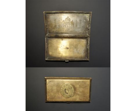
20th century AD. A hinged cigarette case with 25-year calendar to the lid, sketch map of India and Southeast Asia to the reverse, image of the Taj Mahal in punched-point work to the inner lid with signature 'Aneel K'. 201 grams, 15cm (6"). From an old London collection, formed in the 1980s.[No Reserve] Fair condition.


Lot 203
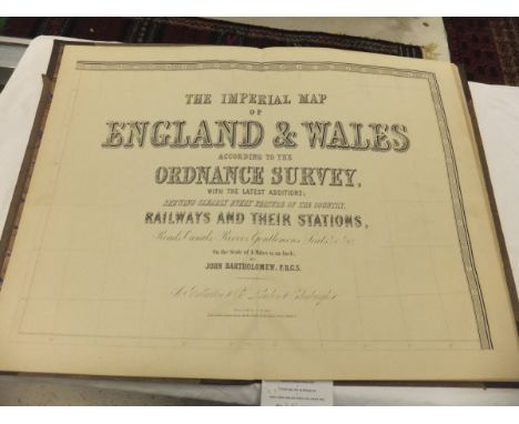
"The Imperial Map of England and Wales according to The Ordnance Survey with the latest additions showing clearly every feature of the country, railways and their stations, roads, canals", on the scale of 4 miles:1 inch, by John Bartholomew, FRGS, published by A Fullarton & Co. London and Edinburgh, folio size, cloth board bound with tooled and gilded leather spine CONDITION REPORTS Exterior very damaged and mouldy and warped. Pages have some wear, dirt yellowing, and some foxing and stains. Map plates appear to be complete. The atlas is not dated. Size is approx 56 x 40cm when closed.

Lot 268
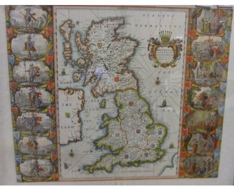
AFTER JOHANNES BLAEU "Britannia Anglo Saxonum Heptarchia", map, black and white engraving, later coloured CONDITION REPORTS Size of the printed image approx 52.5cm x 42cm, total size approx 62 x 52cm. Print is sealed within the frame so unable to check whether or not it is stuck down / laid down. However, the appearance through the glass is fairly flat so it is possible that it may be stuck down. Repaired vertical tears at and near centre fold. Some general wear, dirt and rust type spots. Bears a faded brown ink inscription / number bottom right which appears to read "55". Some smudges and splashes of the red colouring to the map. The board to the back of the frame is stamped "Galerie Ray ..........". The map is believed to be a 17th Century print. NB Print has now been removed from frame, and we can confirm that it is stuck down throughout straight onto brown board, and the edges have been trimmed to the size of the board.


Lot 150
Nachtigal (Gustav) - Sahara und Sudan, vol.1 and 2 only (of 3), first editions , 6 folding maps in pockets at end, plates and illustrations, original pictorial cloth, gilt, vol.2 recased, spine cockled and upper cover with ink stain, a little rubbed, modern cloth slip-case, Berlin, 1879-81 § James (F.L.) The Unknown Horn of Africa, first edition , plates (uncoloured), lacks folding map from pocket at end, hinges broken, original pictorial cloth, spine faded and chipped at head, 1888; and 4 others, Africa, 8vo (4)
Lot 151
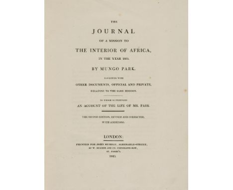
Park (Mungo) - The Journal of a Mission to the Interior of Africa, second edition, half-title, folding engraved map with outline hand-colouring (offset), 4pp. advertisements at end, uncut in original boards, spine rubbed and chipped, 1815; Travels in the Interior Districts of Africa, second edition, engraved portrait frontispiece, 3 folding maps (one torn and backed), 5 engraved plates, 2ff. music, foxed and browned, a few tears, contemporary tree calf, rebacked, rubbed, 1799, 4to (2)
Lot 159
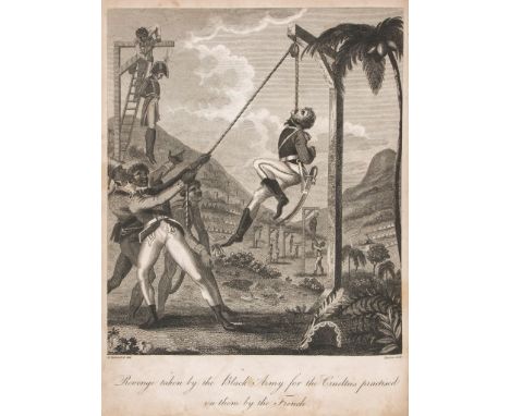
Central America.- Rainsford (Marcus) - An Historical Account of the Black Empire of Hayti, first edition, engraved frontispiece, folding map, folding plan, 8 plates, 3pp. engraved facsimile, 3pp. advertisements, lacking half-title, one plate with closed tear repaired to reverse, some general marking and light soiling, contemporary calf, worn, rebacked, upper cover detached, 4to , 1805.

Lot 162
Nieuhoff (Jan) - An Embassy from the East-India Company of the United Provinces, to the Grand Tartar Cham, Emperor of China.... , second edition, translated by John Ogilby, title printed in red and black, additional engraved title, double page engraved map of China and 17 engraved plates (1 double page), numerous engraved vignettes, lacking 8 leaves text (sig Rr and others at end), closed tear to title repaired, closed tears to additional title, 3 plates and some leaves of text, upper margin of sig Ss2 repaired affecting engraved vignettes, some browning and staining, bookplate to upper pastedown, contemporary calf, lacking lower cover and most of backstrip, worn, folio, by the author in White-Friers, 1673; sold not subject to return.
Lot 167
Indian Mutiny.- - Narrative of the Indian Revolt, from its Outbreak to the Capture of Lucknow, lacks the map and battle-plan, many text illustrations, several full or double-page, modern half morocco, marbled boards, 1858 § Trotter (Lionel J.) The Life of John Nicholson, Soldier and Administrator, half title, 2 portraits, 3 folding maps, 1 torn at fold, text-illustration, contempoprary half calf, rubbed, covers scuffed, 1897 § Fitchett (W.H.) The Tale of the Great Mutiny, portraits, maps, 1 folding, 8pp. advertisments at end, original cloth, rubbed, t.e.g., 1901, 4to & 8vo (3)

Lot 176
Russia.- Blaeu (Johan and Cornelius) - Russiæ, vulgo Moscovia, pars Australis, southern Russia, title cartouche surmounted by wolves , upper right, Imperial arms supported by armed noblemen, upper left, scale cartouche supported by nobelwoman and fur traders, lower right, engraved map with original hand-colouring, 385 x 520mm., slight splitting at foot of central vertical fold, slight surface dirt, Amsterdam, c.1648.
-
109182 item(s)/page