We found 109182 price guide item(s) matching your search

Refine your search

Year

Filter by Price Range
  • List
  • Grid
  • 109182 item(s)
    /page

Lot 754

JOHN SPEED. A map of Cardiganshire, engraved map, coloured, 15 x 21 in

Lot 755

JOHANNES BLAEU. Penbrochia, engraved map, coloured, 16 x 21 in

Lot 765

JOHN SPEEDE. An engraved map of Herefordshire, coloured,16 x 21 in; and an unframed map titled 'Breknoke-Shyre and Town Described'; two (2) A/F

Lot 761

AFTER B.D. HOOKE. Broadstairs, engraving, 10 x 19 1/4 in; sold with a colour lithograph after Michelangelo Hayes depicting the 22nd (Cheshire Regiment); a lithograph after Thomas Dutton depicting 'The Brilliant 307 Tons'; An engraved map, coloured, of Northamptonshire by Emmanuel Bowen; together with another map which depicts Worcestershire (5)

Lot 625

An oval embroidered Map of England with the German Ocean. With an embroidered flower border. 1795. Framed and glazed. 20in H

Lot 756

JOHANNES BLAEU. Denbigiensis Flintensis, engraved map, coloured, unframed, 15 x 20 in

Lot 754A

JOHN SPEED .'Anglesey, Antientley,(sic) called Mona described', engraved map, coloured,15 x 20 in

Lot 320B

SIR WILLIAM PETTY ND GEORGE WILDEY (1707-1737)A Map of Ireland and a Map of Munster, Connaught, Leinster and Ulster. From issued separately or as a collection to be included in composite atlases of the day. 560 x 440. Abl 24(ii). (5)Provenance: The Richard S.J. Clarke Collection

Lot 372

MAP OF IRELAND, Irish school, circa 1950s, published by the Dublin General Steam Shipping Co. Ltd, coal merchants, 18 D'Olier Street, Dublin, photomechanical colour printed map, 50 by 37cm, printed by Fergus O'Connor, Dublin, circa 1950.

Lot 386

DOUGLAS, JAMES, BOMBAY AND WESTERN INDIA. A Series of Stray Papers. 1st ed. Octave. L. 1893. 2 vols. Red buckram with gilt amorial shield to front bd. Some staining and scuffing to same. Some uncut pages. Contains 2 fabulous fold out maps of Bombay and numerous plates. Some Irish interest. Along with Josiah Bateman, The Life of the Right Rev. Daniel Wilson, Late Lord Bishop of Calcutta and Metropolitan India... L. 1860. 8vo., 2 vols. Frontis of Wilson, with further portraits, illus. and map. Cont three-quarter leather with green buckram boards. Scuffing to bds and wear to spines. [4].

Lot 1

John Speed and Christopher Saxton, after Abraham Goos "The Kingdome of England" - a map with vignette portraits engraving with hand-colouring 40 x 52cms; 15 3/4 x 20 1/2in.

Lot 15

After James Pollard and R*** G*** Reeve "Fly-Fishing For Trout" and "Live-Bait Fishing For Jack" re-strike aquatints with hand-colouring 23 x 31cms; 9 x 12in.; together with a map of the salmon pools at Haughton Castle, limited edition, signed proof, Ginty Bewick, 1993. (3)

Lot 2

William Blaeu "Comitatus Northumbria Vernacule Northumberland" - a map decorated with armorial shields engraving with hand-colouring 41 x 49cms; 16 1/4 x 19 1/4in.

Lot 3

Robert Morden A map of Northumberland engraving coloured by hand 43 x 35cms; 17 x 14in; together with a smaller map of Northumberland, by Thomas Kitchin; and a map of Durham, by Richard Blome. (3)

Lot 162

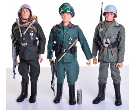
Two Palitoy vintage Action Man Soldiers of the World German Figures, Stormtrooper, helmet, tunic, trousers, boots, cartridge belt, luger pistol and holster, field pack, Schmeisser machine gun, two stick grenades, Iron Cross, on flocked hair fixed hands doll, German Staff officer, cap, jacket, breeches, jackboots, belt, luger pistol and holster, sand goggles, binoculars, map, case and iron cross, on gripping hands flocked hair doll and late issue German Stormtrooper, helmet, combat jacket, trousers, boots, Y harness equipment webbing, water bottle, stick grenades, bayonet, scabbard, KAR 98 rifle, on eagle eyed doll, all in excellent condition (3 items)

Lot 165

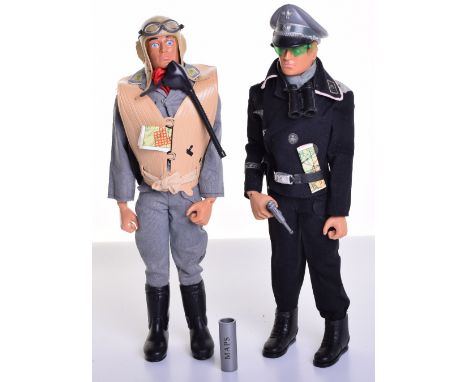
Palitoy vintage Action Man German Luftwaffe Pilot, on blond flocked hair, gripping hands, eagle eyed doll, flying helmet, oxygen mask, goggles, scarf, jacket, trousers, boots, luger pistol and holster, belt, map and life jacket with tie, in mint off the card original condition and German Panzer Captain, on blond flocked hair, gripping hands, eagle eyed doll, cap, goggles, scarf, jacket, trousers, boots, luger pistol and holster, belt, binoculars and map, in excellent original condition (2 items)

Lot 166

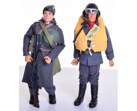
Palitoy vintage Action Man Battle Of Britain Pilot, on brown flocked hair, gripping hands, eagle eyed doll, flying helmet, oxygen mask with air hose, goggles, scarf, tunic, trousers, boots, , belt, map and Mae west life jacket and Royal Air Force Working dress outfit on brown flocked hair gripping hands doll, with accessories, both in very good original condition (2 items)

Lot 281

J. Blaeu, STERLIN-SHYR, a hand coloured map, 49.5cm x 58cm.

Lot 328

Daniel Augustus Beaufort LLD 'Memoir of a Map of Ireland' illustrating.......Civil and Ecclesiastical' published London 1792 and one volume Paterson's Roads by Edward Mogg, London 1826

Lot 518

After Robert Morden 'Berkshire' a county map printed for Abel Swall and Awnsham & John Churchill 36cmx42cm

Lot 523

After J Speed 'The Invasions of England and Ireland with all their Civil Wars since the Conquest' coloured engraved map sold by Thomas Bassett & Richard Chiswell 39.5cmx51cm

Lot 240

Braun, Georg (1541-1622) and Franz Hogenberg (1538-1590). Edenburg: Edenburgum Scotiae Metropolis, 16th century double-page hand-coloured engraved map, French text to the border dated 1597 39.5cm x 53cm, framed and glazed

Lot 150

An early 19th century map of Westmorland, later coloured

Lot 159

An early 19th century map of Lancashire after Cundee, later coloured and dated 1815

Lot 643

FOUR OLD FRENCH MAPS, De La Marche, Lorraine, Bourgogne and Poitou, one map of England, 67cm x 54cm, one map of French departments, 59cm x 68cm and one map of the United Provinces, Dutch, Austrian and French, 20cm x 28cm, framed, glazed. (7)

Lot 239

Large selection of various military style maps including maps of training areas including Warcop Jpint Operations Graphic, map charts etc

Lot 176

Automobilia - 'The Autocar Map for Motorists' vintage hanging wall map (rolled) H143cm

Lot 39

'The East Riding of Yorkshire', late 17th century Robert Morden map, hand coloured 37cm x 43cm

Lot 39A

'A New Map of Yorkshire', hand coloured 18th century engraving by Thomas Conder pub Alex.Hogg at the Kings Arms Paternoster Row c1786, 21cm x 32cm

Lot 40

'Eboracensis' - County map of Yorkshire, colour print 54cm x 73cm

Lot 277

A World War II officer's canvas map case, dated 1944; together with a presentation letter June 1946 with King George facsimile signature ; and Borough of Milngavie Victory Celebration medal

Lot 159

MONTAGU (LORD), "THE CAR" ROAD AND GUIDE BOOK, new edition revised, with large folding map, leather folding cover with printed adverts and inset compass, London, Car Illustrated, 1914 (1)

Lot 160

WRIGHT (REV G), THE SHORES AND ISLANDS OF THE MEDITERRANEAN, with engravings by Temple, Leitch, Irton & Allen, with folding map and plates complete as per list, ¾ leather with marbled boards, London, Fisher & Son, c1830, watermarks to inner bottom corner (1)

Lot 179

BRITTEN'S OLD CLOCKS AND WATCHES AND THIER MAKERS, 7th ed, Bonanza Books; LYMAN (I), RAILWAY CLOCKS; PONT (T), CUNINGHAME folding map and other illustrations, Glasgow, 1876; with other Scottish related books; GIBBINGS (R), THE CHARM OF BIRDS, 1927; and one other book (7)

Lot 192

GILPIN (W), REMARKS ON FOREST SCENERY, vol II only, folding map and other plates, 1808; HOOKER (W), CURTIS'S BOTANICAL MAGAZINE, no plates, London, 1858; WHITE (REV. G), THE NATURAL HISTORY OF SELBORNE, gilt green cloth, London, 1875; MRS BEETON'S BOOK OF HOUSEHOLD MANAGEMENT; R.H.S Colour Charts - pantones, for 1966, and other items (Qty)

Lot 196

THE IRTON ESTATE IN THE COUNTY OF CUMBERLAND, particulars and conditions of sale 1872, offered for sale by Mr J R Wallace, with large folding map and dated 19th Sept 1872 (1)

Lot 203

A collection of 17th century and later documents, to include a vellum commission to Anthony Benn Esquire as Captain of a Company in the Battalion of the Militia in and for the said county of Cumberland, a certificate to Thomas William Falcon of Queens College Oxford into the Holy Order of Deacons, 21st December 1844; a 1680 indenture, a letter from John Doyle to Thomas Crosby dated 2nd April 1677; a Map of Cumberland and Westmorland by William and Whellan & Co dated 1858; a lease for Newton Manor Estate to Furness Railway Company dated 1877, assorted early 19th century Cumbrian and other newspapers etc (Qty)

Lot 20A

'The Royal Geographical Society Silver Map' of the world, limited edition, 925/1000, John Pinches, London 1976, framed, 52cm x 70cm overall

Lot 19

17th Century map of Suffolk, Robert Morden, circa 1695, hand coloured, 43cm x 38cm excluding glazed frame

Lot 3

18th Century map of Suffolk, hand coloured, 20cm x 16cm excluding frame

Lot 35

George III map sampler, signed by J.A. Fairhairn, 1812, with a flower border, unframed, 48cm x 52cm

Lot 385

1840's hand drawn map of Europe, scroll fitted, written to the base Drawn by George Rendall, April 1840?, 54cm x 53cm

Lot 629

17th Century map of Yorkshire 1659. Together with a map of Provence of Galliae and a framed map of Spain (3)

Lot 69

18th Century engraving of Bury St Edmunds Abbey, together with a 1698 road map to Bury St Edmunds (2)

Lot 734

18th Century manuscript map of a Norfolk estate, circa 1763, titled 'A plan of the Estate belonging to Mr Daniel Whalne, Lying in the Parish of Pulham St Mary, Magdalen and Hardwick, in the County of Norfolk, by H Hatton 1763', 48cm x 38cm excluding frame

Lot 123

A sleeve of waterproof maps, together with a Bacon's Lake District map

Lot 1959

GEORGE III MAP SAMPLER, by H Fitter, 1787, titled 'A Map of England and Wales' to a cartouche, with eastings and northings border, 50 x 44cm

Lot 63

A BLUE GLASS SCENT BOTTLE ENGRAVED WITH A WORLD MAP H 14 CM DIAMETER 8 CM

Lot 602

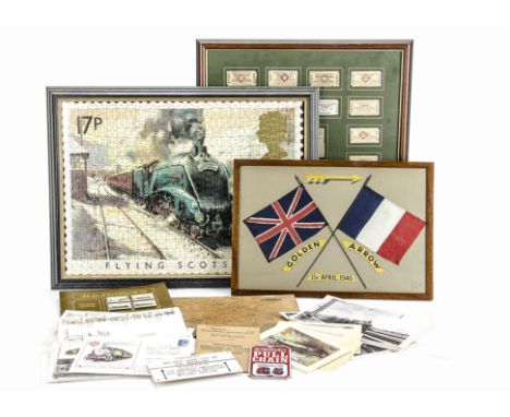
Collection of Railway-Related Ephemera: including a framed set of Southern Region tickets, a framed plaque commemorating the post-war reinstatement of the Anglo-French 'Golden Arrow' train (1946), various postal First Day Covers including some with KWVR, Festiniog and Rainhill Rocket 150 Supplementary stamps, a BR (WR) board-mounted map, photographs of 1970's steam specials, and other items, overall G-VG (qty)

Lot 604

A Framed Original Brunel Planning Map of the Great Western Railway, circa 1835-6: showing the section between Harlington and Taplow, including the Eton Branch from Slough, with colourwashed details of Parishes and land parcels traversed, and including a level survey with proposed gradient profiles for the lines, with inked no '2' in the top right-hand corner indicating part of an original series, overall G-VG, various smaller tears/damage around edges, and nicely mounted in a more recent gilt-edged wooden frame, measuring 29" x 20"

Lot 1488

John Speed Framed Map Of Surrey, Dated For 1610. Appears To Be Laid Over One Other. 14 x 19 Inches. As Found Condition. Together With One Other.

Lot 68

A quantity of railway related items including a letter from Station Master Office dated 8th June 1858, a hand drawn map of Stainby Branch and Corby Glen, British Rail's Board Rule Book dated 1972, a Baric hand lamp, British Rail branded dusters, a Station Master's British Rail cap badge, and a platform 3d ticket from Llanfairpwllgwyngyllgogerychwyrndrobwllllantysiliogogogoch dated 1964 (full list available).

Lot 799

A Victorian hallmarked silver cased circular "Rota-Meter" map measure, diameter 2.7cm. CONDITION REPORT: This is functioning.

Lot 447

An early 17th century large Geneva/Breeches Bible including the Apocrypha, illustrated with mostly woodcut engravings and in-text maps, and at the end, a table of interpretations of proper names and an alphabetic list of the principal things in the bible. Printed by Andro Hart in Edinburgh in 1610, this edition, printed the year before the King James Bible in 1611, was the second edition of bible printed in Scotland and widely regarded as a Geneva/Breeches Bible, although there is a suggestion that the Old Testament translation is largely from Bassendyne's edition. It retains the original corrections to the text stuck to the pages in Exodus and Deuteronomy. The New Testament title leaf bears inscribed family names and dates to front and verso. Rebound in leather on board, 33.5 x 23.5cm. Plus an early 19th century rebound copy of the Apocrypha with gilt page edges (2). CONDITION REPORT: The leather binding is in distressed condition, the initial pages and the final pages are worn to the edges, small cuts to the first 15 pages where thumbed, seems to be complete. First printed page is title page. Last page is "The Second Table". Dated 1610. Please see additional photos for title pages. First pages of Genesis and Matthew and last page of Revelation are present. There are 5 printed pages before the general title page. There is a small map at Genesis II and two full page engravings at Exodus. No issues of loose or missing pages evident.

Lot 865

A military cartographer's map holder with leather strap, compass point signed "Aston & Mander London", a roll of paper, an Army Book 156 Signal Register Cover, and a pair of military ear protectors.

Lot 378

A superb early gilt framed embroidered silk map of England. W54xh65cm

Lot 3026

Thomas Badeslade. Reasons humbly offer'd to the Consideration of the Publick; Shewing how the works to recover and preserve the Navigation of the River Dee will destroy the Navigation, 4to, paper bound, limited edition 100, with a hand drawn map of the Chester River, printed by Roger Adams, Chester 1705.

Lot 3033

William Tindale. The History and Antiquities of the Abbey and Borough of Evesham, first edition, 4to, half calf, nine engraved plates and a map, published by John Agg, London 1794.

Lot 3063

An album of Victorian and later sentimental and topographical postcards, including views of Lincolnshire, WWI silk cards, a Victorian portrait photograph album, books of cigarette cards, an Ordnance Survey map of Grantham and a local, section F, Motoring and Touring map.

Lot 572

ASTRONOMY, Drehbare Kosmos-Sternkarte (Rotating Cosmos Star Map), pub. by Kosmos, with large circular chart of the Northern Hemisphere, with instruction booklet (in German) and original folder (small tears), VG

Loading...Loading...
  • 109182 item(s)
    /page

Recently Viewed Lots