We found 109182 price guide item(s) matching your search
There are 109182 lots that match your search criteria. Subscribe now to get instant access to the full price guide service.
Click here to subscribe- List
- Grid
-
109182 item(s)/page


Lot 405
Coastline coloured map etching, "Burlington Bay, Scarborough and Hartlepool. to Capt. Ralph Sanderson, this chart is a dedicated and prefented by Cap't Greenvile Collins hydrog'r to the King, coloured map engraving "A Map of the parish of St. Mary Rotherhith, Published according to the act of parliament 1755 for Ston's Survey", P. Potter, engraved plan. "Lands at Scrooby" (3)


Lot 407
Coastline map etching, "Burlington Bay, Scarborough and Hartlepool. to Capt. Ralph Sanderson, this chart is a dedicated and prefented by Cap't Greenvile Collins hydrog'r to the King, The Dispatch Atlas coloured map etching, the River Thames from it's source to the sea, S. Hall, coloured two sheet map etching depicting Scotland, The Dispatch Atlas Orkney Islands and Shetland Islands, J & C Walker map of England and Wales, Francis Young map of England and Wales, S. Hall map of England and Wales, coloured map of The Orkney and Shetland Islands (9)


Lot 451
British County maps, to include Dugdales England and Wales Delineated, Merionethshire, Glamorganshire, Rutlandshire, Staffordshire, Monmouthshire, Huntingdonshire, Bedfordshire. World maps to include Les Colonies Pheniciennes, a new and accurate map of Saxony printed for J Hinton, Hellas or Greece, three atlas title pages, principal countries of the ancient world (qty)


Lot 597
Early 1963, Morris Cooper 997 lightly modified for fast road/club rally use and in need of recommissioning.Correct early 1963 Engine and Chassis numbers. Certified Copy of a Factory Record from BMI Heritage TrustModified in the past for fast road/ Club Rally use. Modifications to engine and gearbox unknownStraight-through 'Maniflow' competition exhaust, K&N filters, FACET Gold-top electrical fuel pump, twin tanks, lightweight bonnet, MinilitesOMP competition seats with LUKE 5-point harnesses. Safety Devices 'Classic Mini' 6-Point bolt-in Roll Cage. Modified dash, internal fuses, drilled pedals, map light. External ignition cut-offBuilt on 26/03/1963 and finished in Almond Green/OEW roof, later repainted in Tartan RedWe understand that the vehicle starts and runs and all electrical systems workTax disc in windscreen indicates last taxed to November 2000 and we assume was last used thenVery sensibly guided for a Cooper of this era and a great opportunitySpecificationMake: MORRISModel: MINI COOPERYear: 1963Chassis Number: KA2S4 382213Registration Number: 554 EUGTransmission: ManualEngine Number: 9F-SA–H/19021Drive Side: Right-hand DriveOdometer Reading: 27077 MilesMake: RHDInterior Colour: Red

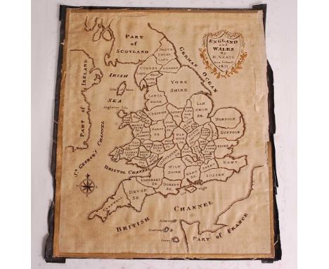
Lot 328
An early 19th century silk laid on canvas map sampler of England & Wales, embroidered with the counties of England and Wales and showing part of Scotland, part of Ireland and part of France, having embroidered shield within a wreath to the top right stating 'ENGLAND and WALES By N. NEATE Box School 1811', with compass embroidered to lower right, unframed, gross dimensions 30 x 25.5cm


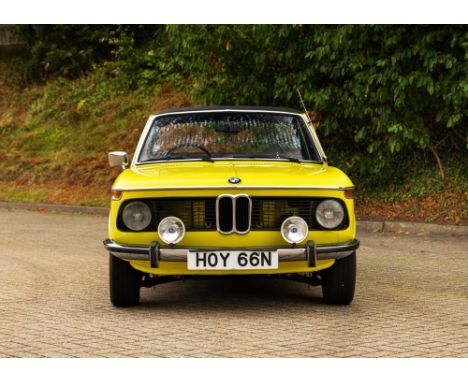
Lot 191
1975 BMW 2002 Cabriolet Transmission: manualMileage:6312The BMW 2002 series is important in the history of BMW for several reasons; not the least of which being that it brought the company out of near bankruptcy in the 1960’s and put BMW on the map in the United States. It was the ancestral grandfather to the BMW 3 Series and was produced from 1968 to 1976. German BMW importer Max Hoffman is credited with the car's creation. He had suggested to BMW's engineering director that a 2.0 litre engine should be installed into the small two-door 1602 to improve performance and emissions. The resulting 2002 (named after the new motor's displacement) was popular in its first year on sale. This BMW 2002 is one of only 354 examples manufactured in right hand drive format and one of only 24 manufactured in 1974. Conversions on these outstanding vehicles were carried out by coachbuilder Karosserie Baur in Stuttgart. Baur retained a ‘T’ bar in the roof design helping dramatically to reduce any scuttle shake. This 2002 cabriolet was purchased by the vendor in 2018 after the car had benefitted from a full bare metal restoration in Poland the year before, with receipts in the file for over €4,500 in parts alone. Finished in yellow with a black interior, the car was then subject to a full mechanical restoration back in the UK. Almost £5,000 was spent between renowned historic motorsport teams Macchina Motorsport and TTP Performance to get the car mechanically sorted, with TTP Performance carrying out a full engine rebuild. The car is now reported by the vendor to be ‘on the button’ and to run and drive extremely well. Supplied with a UK V5C registration document, almost all of its early MoT test certificates, invoices running back to 1980 and original sales brochures, this wonderful, fully restored BMW classic is now ready to enjoy.Interested parties should note that the estimate for this car is now £12,000 to £16,000.Interested parties should satisfy themselves as to the description and condition of each lot prior to the sale. Accordingly, buyers are on notice that each vehicle is offered ‘as is/as seen’ subject to the Terms and Conditions for the auction. Buyers are advised to inspect the vehicle in person or use a professional to carry out this service. Historics will not entertain disputes over descriptions.


Lot 37
A quantity of Railway related publicationsto include the Minutes of Evidence and Map, Plans and Sections for the 1846 Metropolitan Railway Commission investigation into Railway Termini in the Metropolis, two volumes in paper covers, published London: W. Clowes & Sons, a bound folio entitled 'Great Central Railway, Plans of Railway No. 8 Extending from Canfield Place to Preston Road and of Widening from Preston Road to Harrow also Neasden Yard', printed Hanson & Davidson, 1907, in half morocco, a ledger entitled 'North London, Hampstead Junction, Railway Acts 1846-1874', containing handwritten and printed Acts of Parliament, bound in half morocco, a number of mid-20th century London Transport magazine, etc. (qty)Condition: 1846 commission volumes are in poor condition with covers loose from binding, pages are dog-eared and some torn, some plates torn, stains and markings throughout, folio has cut-out sections, outer boards are rubbed, ledger has cover separated from spine IMPORTANT: ALL TRANSPORT SIGNS AND EPHEMERA WILL BE AVAILABLE FOR COLLECTION FROM OUR OFF SITE WAREHOUSE IN BECKENHAM BY APPOINTMENT ONLY. PLEASE CALL 0208 468 1010 TO ARRANGE AN APPOINTMENT
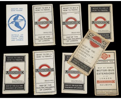
Lot 27
Nine 1910/20s folding pocket maps for London transport,comprising a 1916 General Omnibus Map of some Motor-Bus Extensions, a c.1914-15 London Underground Map of the Electric Railways of London, two 1921 London Underground Map of the Electric Railways of London, issue date 9-3-21, a 1922 London Underground Map, issue number 1-3-22, a 1923 London Underground Map, issue number 1-1-23, a 1924 London Underground Map, issued June '24, a 1924/25 London Underground Map issued November '24 and a London Country August 1923 Bank Holiday timetable, (9)Condition: Generally good, the 1914/15 map is in two sections, some folding line tears, please refer to department for specific condition report
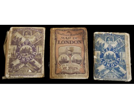
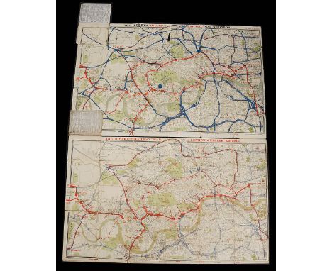
Lot 24
The District Railway Map of London, 5th edition c.1892-3, The District Railway Map of London, 6th edition c.1908 & The District Railway Map of London, 7th edition c.1908,three folding maps printed on paper and backed on linen between card covers, the first published by W. J. Adams & Sons, 59 Fleet Street, E.C., the second and third by Sampson Low, Marston & Company, London, (3)First map measures approx. 66.5 x 106.3cmCondition: markings and stains to all three maps, tears along the section folds, covers loose IMPORTANT: ALL TRANSPORT SIGNS AND EPHEMERA WILL BE AVAILABLE FOR COLLECTION FROM OUR OFF SITE WAREHOUSE IN BECKENHAM BY APPOINTMENT ONLY. PLEASE CALL 0208 468 1010 TO ARRANGE AN APPOINTMENT
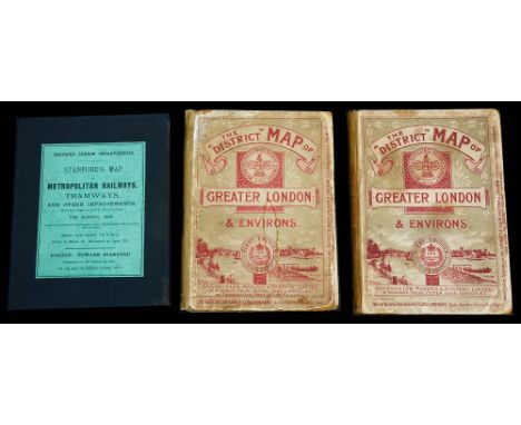
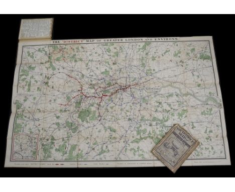
Lot 25
The District Map of Greater London & Environs, 1st edition 1902 & 1st edition 1904, and Stanford's Map of Metropolitan Railways, Tramways, and other Improvements, 1903,three folding maps on paper backed on linen inside hard covers, the first and second published by Sampson Low, Marston & Company, London, the third by Edward Stanford, London, (3)the first map measures approx. 67.8 x 106.2cmCondition: all maps are in fair condition, some marking and staining to the surfaces, wear to the covers but all relatively intact IMPORTANT: ALL TRANSPORT SIGNS AND EPHEMERA WILL BE AVAILABLE FOR COLLECTION FROM OUR OFF SITE WAREHOUSE IN BECKENHAM BY APPOINTMENT ONLY. PLEASE CALL 0208 468 1010 TO ARRANGE AN APPOINTMENT

Lot 23
Stanford's Map of Metropolitan Railways, Tramways, and other Improvements, 1899,folding map printed on paper laid down on linen between two outer boards covers with original label applied and a gilt stamped spine, published by Edward Stanford, 26 & 27, Cockspur Street, Charing Cross, S.W., ex-libris for the Library of the Institution of Civil Engineers, stamped on map upper right,map measures approx. 74.7 x 10⁵cmCondition: The map is in overall good condition IMPORTANT: ALL TRANSPORT SIGNS AND EPHEMERA WILL BE AVAILABLE FOR COLLECTION FROM OUR OFF SITE WAREHOUSE IN BECKENHAM BY APPOINTMENT ONLY. PLEASE CALL 0208 468 1010 TO ARRANGE AN APPOINTMENT
Lot 20
The Improved District Railway Map of London, 1886 3rd edition, and the Jubilee Edition of the District Railway Map of London, 1887,two folding maps, the first printed on paper with advertisements on reverse and between two linen covers, the second printed on paper and laid down on linen between two linen covers, published by W. J. Adams & Sons, 59 Fleet Street, E.C., (2)second map measures approx. 66.1 x 106.8cmCondition: The first has become separated from its covers leaving upper most left hand section of the map attached, multiple tears to the folding seams and edges, tear to the top middle of the map, staining and discolouration, covers are worn, the second has multiple tears between the map sections but overall is still intact, other smaller tears and folds, covers worn IMPORTANT: ALL TRANSPORT SIGNS AND EPHEMERA WILL BE AVAILABLE FOR COLLECTION FROM OUR OFF SITE WAREHOUSE IN BECKENHAM BY APPOINTMENT ONLY. PLEASE CALL 0208 468 1010 TO ARRANGE AN APPOINTMENT

Lot 19
The Improved District Railway Map of London, 1882, 3rd edition, folding map printed on paper laid down on linen between two linen covers, published by W. J. Adams & Sons, 59 Fleet Street, E.C.,map measures approx. 65.6 x 106.6cmCondition: some discolouration to map, small tears and folds to the corners, general marks and some lifting to some sections of the paper, linen covers very worn and only half attached at spine IMPORTANT: ALL TRANSPORT SIGNS AND EPHEMERA WILL BE AVAILABLE FOR COLLECTION FROM OUR OFF SITE WAREHOUSE IN BECKENHAM BY APPOINTMENT ONLY. PLEASE CALL 0208 468 1010 TO ARRANGE AN APPOINTMENT
Lot 34
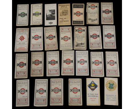
A collection of early 20th century London General and London Underground folding pocket bus route maps,to include July 1912 London General Omnibus Company map, a series of London General bus route maps from c.1921 until 1927 (incomplete), a Whitsuntide 1927 folding timetable, an Easter 1927 folding timetable, two London General Country bus route maps Summer 1924 & 1926, two London General Town and Country bus timetables June & August 1923, (29)Condition: All are in fair condition, some folding line tears and staining, please refer to department for specific condition report requests IMPORTANT: ALL TRANSPORT SIGNS AND EPHEMERA WILL BE AVAILABLE FOR COLLECTION FROM OUR OFF SITE WAREHOUSE IN BECKENHAM BY APPOINTMENT ONLY. PLEASE CALL 0208 468 1010 TO ARRANGE AN APPOINTMENT

Lot 38
A 1920s Metropolitan Railway carriage map and a 1930s Metropolitan Railway carriage map,the first entitled 'Metropolitan Railways and Connections', printed on paper on thick card, issue number M725/500, second showing the Verney Junction/Brill branch of the line, printed on paper laid on board, (2)first measures 21.6 x 62cm, second 19.6 x 61.1cmCondition: The first has adhesive marks to each corner, a damp spot to paper top right hand corner, water stains along bottom edge, some losses to the edges, general fading and discolouration to sign, second has abrasions to bottom edge, generally discoloured and spots IMPORTANT: ALL TRANSPORT SIGNS AND EPHEMERA WILL BE AVAILABLE FOR COLLECTION FROM OUR OFF SITE WAREHOUSE IN BECKENHAM BY APPOINTMENT ONLY. PLEASE CALL 0208 468 1010 TO ARRANGE AN APPOINTMENT
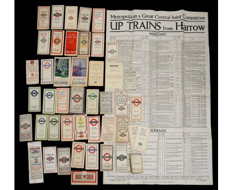
Lot 36
A collection of late 19th to mid-20th century folding maps and guides covering a rage of transport,to include an 1894 Symington & Son pocket train timetable, a number of early 20th century maps for the Central London Railway, 1920/30s London Bus and Underground maps, a 1948 London Olympics London Transport map, a 1951 Festival of Britain London Transport map, 1940s London Underground, Tram and Bus maps, a 1948 Bus map and timetable for Bristol, some reproduction, a large 1931 poster advertising the Metropolitan & Great Central Joint Committee trains from Harrow(46)Condition: Range in condition, generally good, some folding line tears and staining, please refer to department for specific condition report requests

Lot 21
The District Railway Map of London, Jubilee Edition, 1887, folding map on paper backed on linen, presented between two boards with applied period paper label, published by W. J. Adams & Sons, 59 Fleet Street, E.C.map measures approx. 65.1 x 107.9cmCondition: the map is in good condition with some folding and marking to surface, remnants of period newspaper adhered to reverse of linen backing, covers in good condition IMPORTANT: ALL TRANSPORT SIGNS AND EPHEMERA WILL BE AVAILABLE FOR COLLECTION FROM OUR OFF SITE WAREHOUSE IN BECKENHAM BY APPOINTMENT ONLY. PLEASE CALL 0208 468 1010 TO ARRANGE AN APPOINTMENT
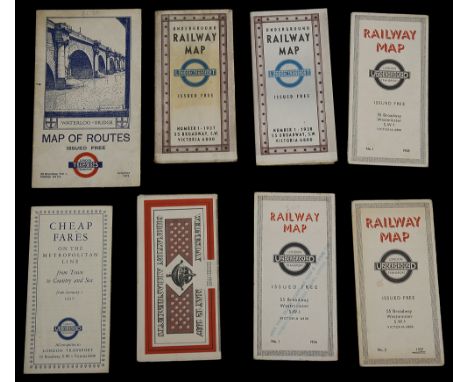
Lot 30
Eight 1930s London Underground folding pocket maps and others,to include a 1936 No. 1, 1937 No. 2 and 1938 No. 1 diagrammatic card Underground map designed by H C Beck, a 1937 Coronation arrangements folding map, a 1937 and 1938 Number 1 Underground Railway Map, a 1933 Tramways Map of Routes and 1937 fare table, (8)Condition: All are in fair condition, some folding line tears and staining, please refer to department for specific condition report requests
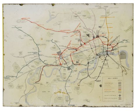
Lot 91
An early and rare London Underground and Metropolitan Railway enamel map,c.1910, manufacturers name bottom right PATENT ENAMEL CO LD B'HAM & LONDONheight 96.6cm, width 127cmCondition: In untouched condition, chipped and corroded edges with loss to the enamel, surface stainsSee London Transport Museum collection reference number 1998/26513 for an identical example dated c.1910

Lot 17
Stanford's Map of Metropolitan Railways, Bridges, Embankments &c., 1863, folding map printed on paper laid down on linen between two outer boards covers, published by Edward Stanford, 6 Charing Cross, S.W.,map measures approx. 66.3 x 86.7cmCondition: the map is in fair condition, some stains and markings to the paper and small pin hole upper right corner, board covers are worn and title label has losses IMPORTANT: ALL TRANSPORT SIGNS AND EPHEMERA WILL BE AVAILABLE FOR COLLECTION FROM OUR OFF SITE WAREHOUSE IN BECKENHAM BY APPOINTMENT ONLY. PLEASE CALL 0208 468 1010 TO ARRANGE AN APPOINTMENT
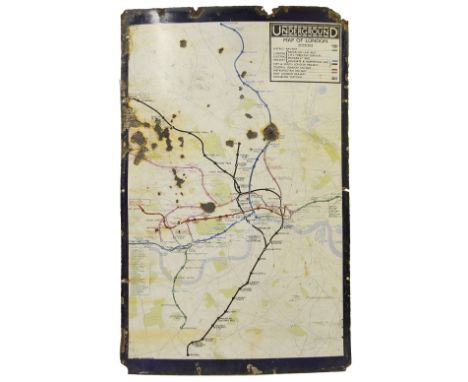
Lot 92
An early 20th century enamel map of the London Underground network,showing only the central London portion of the route, manufacturers name 'CHROMO WOLVERHAMPTON' printed lower right, height 101.7cm, width 63.4cmCondition: extensive holes to the sign surface and edges as well as loss to the enamel and corrosion, discolouration and surface dirt also present
Lot 26
The District Map of Greater London & Environs, 1st edition 1902 & 2nd edition c.1908,two folding maps printed on paper and backed on linen between two hard covers, published by Sampson Low, Marston & Company, (2)first map measures approx. 67.1 x 10⁷cmCondition: maps are in fair condition, no significant tears, stains and markings to the surfaces and covers worn but intact IMPORTANT: ALL TRANSPORT SIGNS AND EPHEMERA WILL BE AVAILABLE FOR COLLECTION FROM OUR OFF SITE WAREHOUSE IN BECKENHAM BY APPOINTMENT ONLY. PLEASE CALL 0208 468 1010 TO ARRANGE AN APPOINTMENT

Lot 31
Ten late 1930s/1940s London Underground folding pocket maps and other flyers,including a 1939 No. 1 fold out map, a 1940 No. 2 and 1941 No. 1 diagrammatic card map designed by H. Schleger, and 1945 no. 1 diagrammatic card map by H C Beck, a June 1945 Victory Celebrations Transport Arrangements folding map, and a number of extension maps including the 1939 LNER extension to East Finchley and the Central Line extensions in 1946 to Stratford and 1948 to Loughton, (10)Condition: All are in fair condition, some folding line tears and staining, please refer to department for specific condition report requests IMPORTANT: ALL TRANSPORT SIGNS AND EPHEMERA WILL BE AVAILABLE FOR COLLECTION FROM OUR OFF SITE WAREHOUSE IN BECKENHAM BY APPOINTMENT ONLY. PLEASE CALL 0208 468 1010 TO ARRANGE AN APPOINTMENT

Lot 22
The District Railway Map of London, 5th edition c.1895,folding map printed on paper laid down on linen between two linen covers, published by W. J. Adams & Sons, 59 Fleet Street, E.C.,map measures approx. 65 x 105cmCondition: Overall in good condition, some marking and small tears to the map, covers worn but intact IMPORTANT: ALL TRANSPORT SIGNS AND EPHEMERA WILL BE AVAILABLE FOR COLLECTION FROM OUR OFF SITE WAREHOUSE IN BECKENHAM BY APPOINTMENT ONLY. PLEASE CALL 0208 468 1010 TO ARRANGE AN APPOINTMENT


-
109182 item(s)/page