We found 109198 price guide item(s) matching your search

Refine your search

Year

Filter by Price Range
  • List
  • Grid
  • 109198 item(s)
    /page

Lot 438

John EmslieGeological Map of Ireland. Published by Reynolds, 1860. 220 x 280.Thomas StarlingIreland. From The Royal Cabinet Atlas. Published by Bull, London, 1834. 89 x 143. Abl 311(ii).John CaryA New Map of Ireland. Published by MacGowen & Davis, 1781. 183 x 223. Abl 125(i).A New Map of Ireland from The Field of Mars. Published London, 1801. 183 x 223. Abl 125(ii). (4)

Lot 441

Henry TeesdaleIreland (with the railway added)From Teesdale's A New Grand Atlas of the World, 1848. 336 x 417. Abl 317(v).Military MagazineMaps of the Counties of Mayo, Sligo etc.From The Military Magazine, published October 1788. 311 x 263. Royal MagazineA Map of the Province of UlsterEngraved by Rolles for The Royal Magazine. 175 x 100. (3)

Lot 442

James PigotA Map of Ireland'Pigot & Co. Map of Ireland'. From Pigot & Co.'s British Atlas (1840). 525 x 675. Abl 326(ii).

Lot 443

Isaac Slater (1829-1878)Slater's (late Pigot & Co.) 'New Map of ... ' from Slater's New British Atlas. 525 x 675. Abl 326(iii).

Lot 444

The Society of the Diffusion of Useful KnowledgeThree Maps of IrelandTwo editions of the single sheet map and one copy of the two sheet map. Abl 346. (3)

Lot 446

Flemming, Carl (1815-1879)A Map of IrelandFrom Universal Hand-Atlas (1844). 299 x 368. Abl 377.

Lot 447

AnonFour Maps of Ireland(i) 'Ireland', John Dower from Milner's Descriptive Atlas (1850)Abl 303(v); (ii) 'Ireland' from John Lothian's The People's Atlas (1896), Abl 391; (iii) 'A New Map of Ireland ...', Anon From Cooke's Modern and Authentic ... Geography (1803), Abl SG 56(i); and (iv) another engraved by C. Clark. (4)

Lot 449

William Home Lizars (1788-1859)A Map of IrelandFrom his General Atlas (1853). 220 x 250.

Lot 451

G. RollosA Map of UlsterFrom The Royal Magazine. 175 x 105.

Lot 452

John Tallis(i) A Map of Ireland. 240 x 345cm; (ii) A Town Plan of Belfast. 245 x 345. (iii) A Town Plan of Cork. 345 x 270. (C.1851). (3)

Lot 457

William Faden (1749-1836)A Plan of the City of DublinFrom Malton's Picturesque Views of Dublin. First edition, 1797. This map is normally found in early editions of Malton's book 1797. Abl G 31.

Lot 458

AnonA New and Accurate Map of the Kingdom .... From The Universal Magazine, 1799. 275 x 315. Abl 56 48.IrelandFrom the later editions of Salmon's A New Geographical and Historical Grammar, 1862-72.Abl SG 1(ii)A New and Correct Map of ...Engraved by Paas in Russell's New Historical and Commercial History of Geography, 1800-1815. Abl SG 51.

Lot 46

Johannes van Keulen (c. 1654-1715)Chart of Ireland and the Irish Sea Koeman No. 298. It occurs first in van Keulen's Zee-Atlas of 1718 and then in De Nieuwe Groote Lichtende Zee-Fakkel of 1734 and in some subsequent editions.The chart shows all of Ireland and the coast of Great Britain from Land's End to Ayr. In Ireland the Ards peninsula, Island Magee, the tip of Innishowen and Mullet are all shown as islands. The title, in a plain oval frame over Wales, reads Nieuwe Paskaart van Ierland en de West kust van Engeland Vervattende in sig St. Joris en het Verkeerde Kanaal, Gelegt naer de Nieuwste ondervinding van ervaren Zeelieden. The New sea Map of Ireland and the West Coast of England containing St. George and the Channel of Bristol made according the newest experience of Expert Mariners. The publisher's imprint is in a rectangular frame with scroll-like ends, in the top right corner, and reads te Amsterdam by Joannes Van Keulen Boek en Zeekaart verkooper aan de Nieuwen Brug met Privilegie. The scales are in the lower right corner reading Duytsche Mylen van 15 in een Graad 25 [= 184 mm.] Fransche Mylen van 20 in een Graad 33 1/3 [= 184 mm.] Engelsche Mylem van 60 in een Graad 100 [= 184 mm.] Schotse Mylen van 50 in een Graad 40 [= 91 mm.] Ierse Mylen van 48 in een Graad 40 [= 91 mm.]. There are soundings scattered round all the coasts as well as four compass roses showing north at the top and scales of latitude on either side of the chart. (977 x 595 mm.).

Lot 461

Matthew Wren (fl.1761-68)A Map of the County of LouthIn four sheets. 430 x 595.

Lot 462

George Taylor and Andrew SkinnerA Map of the County of Louth in Four PartsFrom The Grand Jury Map of the County. Engraved by Garrett & Terry, London (1777). 520 x 675 each.

Lot 463

Alexander TaylorA Map of the County of KildareIn six sheets. From The Grand Jury Map of the County. 1783. 780 x 590 (each).

Lot 463A

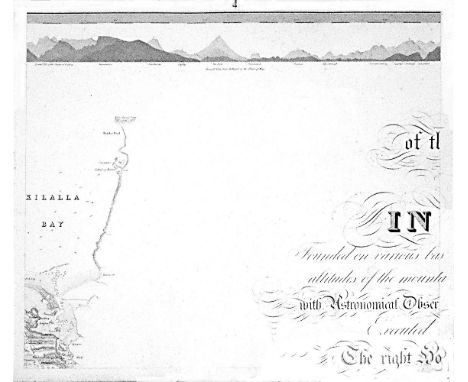
William BaldMayo, Map of the maritime County Mayo in Ireland.Founded on various bases and trigonometrical operations, exhibiting barometrical altitudes of the mountains, the levels and depths of the bogs and lakes; with Astronomical Observations, Physical Sections and Profiles of the Country; Executed by order of the Grand Jury. The Right Honourable Denis Brown M.P. and Member of the Dublin Society, and Royal Irish Academy, foreman; Commenced in 1809, and terminated in 1817, by William Bald F.R.S.E. Member of the Royal Geographical Society Paris, Member of the Geological Society London, Member of the Royal Irish Academy, Honorary Member of the Wernerian Natural History Society Edinburgh. Engraved by Pierre Tardieu, 1830. overall dimensions when joined. 3.11m x 2.57m average sheet size 620 x 510By William Bald, a massively detailed map of Mayo in 25 sections, each varying slightly in size; a little detail here and there of adjacent counties. Large title cartouche. Extensive table of mountain heights. Lake levels; bog levels and depths. Coastal soundings. Plan of trigonometrical base lines. Scale 1 inches to 1 mile. Published by the Mayo Grand Jury. Some edges frayed and some light foxing otherwise in very good condition. William Bald was born in Burntisland in 1789. He was employed as an apprentice under the celebrated Scottish surveyor, engraver and mapmaker, John Ainslie. Bald made a survey of Harris in 1805 when he was only 16, and was later responsible for surveys of ~Benbecula, south Ulst, Eriskey and Argyll, possibly because the tugged nature of the terrain would have been difficult for Ainslie, then in his 60s. These and other of his surveys were later incorporated into Aaron Arrowsmith's map of Scotland. By the time Bald arrived in Mayo in 1809 as county surveyor, he had been described by his teacher and mentor John Ainslie as a very big man... In the words of John Andrews, no ordinary tribute for a twenty-year-old. Bald's first commitment in Mayo was a Grand Jury map of the county. At the same time, he managed to work for the Bogs Commission on their brief for a survey of the bogs of Ireland. Both surveys were to degree of sophistication and meticulousness which far outstripped anything known in Ireland up to that time. His map of Mayo was unique in its scale and scholarship. The base measurement and triangulation were impeccable. Bald spent 18 years on the Mayo survey and engaged Pierre Tardieu in Paris, the foremost engraver of his day, to bring the map to fruition. This was done very slowly and at great expense, finally reaching the light of day in 1830. Bald was a familiar figure in Castlebar, much admired by some, yet disliked by others who through envy of his great expertise, carped at his efforts; or who, unused to the sheer cost of mapping on such a scale, complained at his lavish use of public money. Bald went on to plan surveys of Clare and Down. He even envisaged a general triangulation of Ireland and a new geological map. He still found time to attend to roads and bridges in his adopted county. The coming of the Ordnance Survey spelled the end of the era of the great land surveyors, Bald among them. In later life, he concentrated on roads, bridges, canals and harbours, and eventually railways. He was a principal adviser in the early deliberations of the Ordnance Survey. William Bald loved Mayo, as can be seen from his Map. The profusion of place names, particularly coastal place names, attests to his love of the Mayo landscape, so like his native Scotland. He was one of the ablest, most hard-working and most creative map-makers ever to practise in Ireland. He died in 1857; he is buried in Highgate Cemetery, London. His wife, Anne, pre-deceased him; she is buried in Straide, Co. Mayo.

Lot 466

David de la Feuille (1663-1709)A Map of LimerickFrom his Atlas Portatif. Published in Amsterdam in 1702. 125 x 120.

Lot 468

Gabriel Nicholas Raspe (1712-1785)A Map of Belfast LoughFrom Schauplatz der Gegenwärtigen Kriege published in 1757. The note refers to Captain Thorot's landing at Carrickfergus in 1760. 360 x 230.

Lot 47

Jan van Loon (c.1620-1686)Mathematician, writer and engraver of Amsterdam, was involved in several map publishing projects, but little is known about his life. He published his Klaer Lichtende Noort-Ster Ofte Zee-Atlas in 1661, with two charts of Ireland and the Irish Sea, and incomplete cover of England and Scotland.A Chart of Ireland and the Irish Sea (1661)“Pas-caarte om Achter Yrlandt om te zeylen, van Hitland tot aen Heyssant. Nieuwlycx utgegeven. “ And separately. “t`Amsterdam, by Iohannes van Loon, Plaetsnyder en Zee-caertmaker.” From the Klaer Lichtende Noort-Ster Ofte Zee-Atlas (1661), and the second state with the additional number “3” in the lower right corner It is a close copy of a chart by Doncker. 535 x 425.

Lot 478

The Society of the Diffusion of Useful KnowledgeA Map of the Environs of Dublin405 x 335. Abl G 66(i).

Lot 481

A Cartographic CuriosityA Map of the Irish Church Missions in West Galway1858. Printed in colour on linen; together with A Map of Ireland showing the operations of all the Irish Church Missions. 1852. (2)

Lot 63

Jacques Nicolas Bellin (1703 - 1772)(i) Small map of “Irlande” from his Essai Geographique (1757). 140 x 185. Abl 87; (ii) Small “Carte d`Irlande” from his Petit Atlas Maritime (Vol. IV) (1764). 170 x 230. Abl 99; (iii) Small “Plan de la Ville de Dublin” from his Petit Atlas Maritime (Vol. IV) (1764). 290 x 220. (3)

Lot 88

AnonymousA Map and Chart of the North Coast of AntrimEngraved by Poiret (c.1820).

Lot 600

AN ANTIQUE HAND COLOURED ROAD MAP - from Tinmouth to Carlisle by John Ogilby, 1675 13 1/2" x 18" (34.3cm x 45.7cm) overall heavy foxing and staining

Lot 604

THOMAS DIX, EARLY NINETEENTH CENTURY LARGE HAND COLOURED COUNTY 'NEW' MAP OF YORK with 'South East View of York' to the lower right corner 23" x 28 1/4" (58.4cm x 71.8cm)

Lot 607

LATE EIGHTEENTH CENTURY MAP 'Cape fear River ...... and the towns of Brunswick and Wilmington, against which Lord Cornwallis detached a part of his Army, 1781, 9 1/2" x 7" (24.1cm x 17.8cm), framed and glazed

Lot 608

J & C. WALKER, HAND COLOURED AND CLOTH BACKED FOLD OUT 'MAP OF THE WORLD', Castle Street, Holburn, 1844, with border of statistics relating to certain countries, 57" x 64" (144.8cm x 162.6cm) embossed and gilt tooled morocco boards, 14 3/4" x 10" (37.5cm x 25.4cm) map now in two sections, along fold

Lot 679

MARION RHODES ETCHING 'Free Trade Hall, Manchester (1940) 9 3/4" x 6 1/2" (24.8cm x 16.5cm) ETCHING Bygone Manchester, street scene around Albert Square 10" x 6 3/4" (25.4cm x 17.2cm) AND A BYGONE MAP OF MANCHESTER 12 3/4" X 19 1/4" (32.4cm x 48.9cm)

Lot 382

After Gillray, a coloured Cupid, New Pantheon 4, engraving, together with an 18th century Morden map of Surrey, an engraving after Bartolozzi 'Market of Love', three other engravings

Lot 275

A strut backed bedside clock, the clock with luminous hands set in a silver faced frame forming a map of Ceylon, now Sri Lanka. Birmingham 1936. Clock 5cm., frame 10x19cm.

Lot 104

[Stevens (Capt. John)] Monasticon Hibernbicum, or The Monastical History of Ireland. 8vo L. 1722. First Edn., fold. map frontis after Moll, red & bl. title, & 8 port. plts., cont. panel calf, raised bands, mor. label, upr. cover loose, otherwise v. good copy. (1)

Lot 108

John Knox Grogans' Copy, of Johnstown Castle Smith (Charles) The Ancient and Present State of the County and City of Waterford, 8vo L. By A. Reilly 1746. For the Author First. Edn. lg. fold. map of County, fold. plan of City (repaired) & 4 fold. plts. include. 3 v. fine plans of Waterford, Dungarvan & Lismore, cont. tree calf, mor. label. V. good. (1)

Lot 109

Northern Ireland: Hamilton (Rev. W.) Letters concerning The Northern Coast of the County of Antrim, sm. 8vo Belfast 1822. Third, silhouette port. frontis, fold. map, & 6 plts., uncut recent mor. backed; Gamble (John) Views of Society and Manners in the North of Ireland, L. 1819, recent cloth backed boards; Smith (D.) Outlines of The Rocks of Antrim, sm. 8vo Belfast 1868, 4 engd. plts., cloth; Steele (Rev. W.B.) The Parish of Devenish, Co. Fermanagh, Enniskillen 1937, illus., cloth. (4)

Lot 111

Most Desirable Set Smith (Charles) The Ancient and Present State of the County and City of Cork, 2 vols. 8vo D. 1750. First Edn., list of subs., lg. fold. map, lg. fold. plan & 11 plts. (10 of which are fold. include 3 lg. panoramas) cont. sprinkled calf, dbl. gilt fillet borders, tooled gilt spines with double lettering pieces, & with B.P. of Rolle, new in slipcase. * A most attractive clean & desirable set. (2)

Lot 124

Travel: [Taylor (Emily)] The Irish Tourist; or, The People and The Provinces of Ireland, 12mo L. n.d. [c. 1837] Engd. frontis, fold. map of Ireland, cont. hf. mor. tooled gilt spine, mor. label. Scarce. (1)

Lot 125

Croker (T. Crofton)ed. The Popular Songs of Ireland, 8vo L. 1839. First Edn., engd. port. frontis, wd. cut map, & 5 wd.-cut illus., uncut, recent cloth, orig. label laid down; together with a copy of the 1886 Edition of the above with introduction by Henry Morley, unopened, vellum backed cloth. Both v. good. (2)

Lot 133

Travel: [Gough (John)] A Tour in Ireland in 1813 and 1814; ... By An Englishman. 8vo L. [1817] Sole Edn. recent hf. calf, marble sides; The Traveller's New Guide through Ireland, 8vo D. 1815. Fold. map & single page maps, engd. plts. but lacks fold. map of Ireland, cont. hf. calf, tooled gilt spine, mor. label, both very good clean copies. (2)

Lot 134

[Harris & Smith] The Ancient and Present State of the County of Down, containing a Chorographical Description, ... with A Survey of the New Canal;... 8vo D. 1757., lg. fold. map frontis, cont. sprinkled calf, raised bands, good. (1)

Lot 162

1798: Hay (Ed.) History of the Insurrection of the County of Wexford, A.D. 1798, 8vo D. 1803. First Edn., hf. title, lg. fold. map, fold. leaf 'Analysis - Return,' and with 'Authentic Detail,' 20pp. bound in at end, uncut, orig. boards, worn. Scarce in orig. boards. (1)

Lot 167

Attractive Hand Coloured Copy [Wilson (W.)] The Post-Chaise Companion: or Travellers Directory through Ireland, 8vo D. 1786. First Edn., list of subs., hd. cold. frontis, lg. hd. cold. fold. Map of Ireland, & 3 hd. cold. dbl. page plts. (1 map), uncut, recent full calf, v. good copy. (1)

Lot 168

Co. Roscommon: Weld (Isaac) Statistical Survey of the County of Roscommon, ... under the Directions of the Royal Dublin Society. First Edn., hf. title, lg. fold. hd. cold. map frontis, 710pp plus Appendix LXXII, unopened, uncut, cloth. V. clean copy. (1)

Lot 169

1798: Musgrave (Sir Richard) Memoirs of the Different Rebellions in Ireland, lg. 4to D. 1801. First Edn., lg. fold. map of Ireland, & 9 other fold. maps, plans, plts. complete, errata leaf at end, recent hf. purple mor., raised bands, marble sides. V. good copy. (1)

Lot 170

Carr (John) The Stranger in Ireland, lg. 4to L. 1806. First Edn., lg. sepia fold. frontis & 15 sepia plts. (some fold.) plus hd. cold. map, complete, later hf. calf. Good. (1)

Lot 177

Extremely Rare Lithographic Views on the Shannon Privately Printed: Trench (Henry) Cangort Park Roscrea Shannon Floods, Lough Derg Level. The 25 Miles North from Killaloe, 4to n.p. Belfast, Marcus Ward 1879/1880. FIRST & ONLY EDN., dble. page map & 7 cold. litho. plts. (1 dble page), cont. cloth backed printed boards. * Extremely Rare, very good Copy. (1)

Lot 181

Hogan (Ed.) Onomasticom Gaedelicum, lg. 4to D. 1910. First Edn., map frontis, orig. cloth; also I.M.C.- The Annals of Loch Ce, 2 vols. roy 8vo D. 1939, fold. frontis, cloth. (3)

Lot 198

Lenihan (Maurice) Limerick; its History and Antiquities, roy 8vo D. 1884. Second Edn. fold. map frontis & other plts. maps, ports & text illus., cont. hf. mor. mor. label, good; O'Neill Hencken (H.) Cahercommaun: A Stone Fort in County Clare, roy 8vo D. 1938, fold. & other illus., cloth. Good. (2)

Lot 20

Taylor (George) & Skinner (Andrew) Maps of the Roads of Ireland, roy 8vo L. 1778, First Edn., lg. engd. fold. Map of Ireland frontis, engd. t.p., dedit, list of subs (at verso), 288 engd. maps of the Roads of Ireland, recent leather backed marble boards. (1)

Lot 210

Fine Reprint in Special Binding Shirley (Evelyn Philip) The History of The County of Monaghan, Folio L. (Pickering & Co.) 1879. re-printed by Patrick O'D. Fox, Bangor, 1988. cold. frontis, fold. map, illus. thro-out, heavy hf. green mor. marble sides, mor. labels. V. good copy. (1)

Lot 218

Architecture: Papers Read Before The Down and Connor and Dromore Church Architectural Society, During the Year 1844, 4to Belfast 1845. First Edn., & full page litho plts. & map, cont. diced calf, tooled blind borders with gilt fillets spine etc., worn. Scarce. (1)

Lot 224

Scully (Reg. W.) Flora of County Kerry...., thick 8vo hf. title, D. 1916, First Edn., 6 plates (complete), fold. map, Ex. Libris Copy, cloth gilt lettered spine. Scarce. (1)

Lot 24

Grove (Joseph) The Lives of All The Earls and Dukes of Devonshire, Descended from the Renowned Sir William Cavendish, 8vo L. 1764. For The Author First Edn., engd. port. frontis, cont. calf, mor. label; Gaskin (J.J.) Varieties of Irish History, D. 1869. First, 4 litho plts. (include. frontis) & fold. map at end, cloth; 4 other Irish interest. A lot. (5)

Lot 241

With Hand Coloured Map Co. Cork: Townsend (Rev. H.) Statistical Survey of the County of Cork, 8vo, D. 1810, First Edn., lg. fold. hd. cold. map, errata leaf, 749 + 104 pps, contemp. hf. calf, marble sides, mor. label. Good copy. (1)

Lot 242

Irish Travel: Head (Sir Francis Bond) A Fortnight In Ireland, 8vo, L. 1852, Second Edn., fold. map, 16pps adverts at end, gilt decor. cloth. (1)

Lot 249

Travel: Hall (Capt. B.) Extracts from a Journal written on the Coasts of Chili, Peru, and Mexico, 1820, 1821, & 1822, 2 vols. Edin. 1824. Third, 2 hf. titles, lg. fold. map, uncut, orig. boards, spines dam.; also by same author, Schloss Hainfeld,; or A Winter in lower Styria, Edin. 1836 First, 4pp. adverts at end, cont. hf. calf. (3)

Lot 25

Tyner (George) The Traveller's Guide through Ireland, 8vo D. 1794. First Edn., hf. title, & fold. map, cont. hf. calf, cover loose, otherwise good. V. Scarce. (1)

Lot 258

Lee (Grace Lawless) The Hugeunot Settlements in Ireland, L. 1936. First Edn., map frontis; Seymour (St. John D.) Irish Witchcraft and Demonology, D. & L. 1913. First Edn., both cloth. (2)

Lot 26

[O'Connor (Charles)] Dissertations on the Ancient History of Ireland, 8vo D. (James Henry) 1753. First Edn., 12pp list of subs., lg. fold. map, & fold. table, first few leaves damp stain, cont. full calf, lacks label. Scarce. (1)

Lot 261

Townsend (Rev. H.) A General and Statistical Survey of the County of Cork, 2 vols. Cork 1815. First Edn., lg. fold. hd. cold. map only, Vol. I lacks title page, orig. str. grained mor., rebacked , w.a.f. (2)

Lot 270

In Fine Binding Taylor (George) & Skinner (Andrew) Maps of the Roads of Ireland, 8vo D. 1778, First Edn., engd. t.p., dedit, lg. fold. map, 288pps of engd. strip maps, 16pps list of subs at end, marble end papers, full calf, gilt decor. boards & gilt decor. spine. (1)

Loading...Loading...
  • 109198 item(s)
    /page

Recently Viewed Lots