We found 109182 price guide item(s) matching your search
There are 109182 lots that match your search criteria. Subscribe now to get instant access to the full price guide service.
Click here to subscribe- List
- Grid
-
109182 item(s)/page


Lot 63
Burchell, W. J. TRAVELS IN THE INTERIOR OF SOUTHERN AFRICA, 2 VOLS Cape Town: Struik, 1967 LIMITED DE LUXE EDITION numbered 39 of 1000 of which this is one of the 100 bound in full leather, facsimile reprint, 4to, Vol I: 47 + viii + 582 + [1] errata pp, loose folding map + 10 plates of which 3 fold out; Vol II: vi + 648 pp, 10 plates of which 2 fold out; full brown leather with top edge gilt (2)
Lot 64
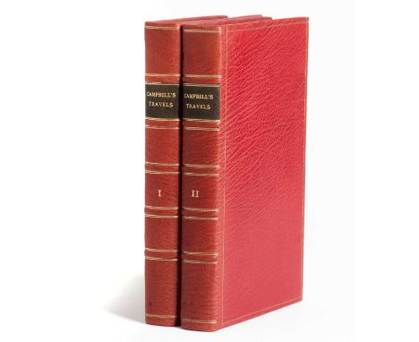
Campbell, Rev. John TRAVELS IN SOUTH AFRICA: A NARRATIVE OF A SECOND JOURNEY IN THE INTERIOR OF THAT COUNTRY, 2 VOLS London: Francis Westley, 1822 FIRST EDITION, 8vo, Vol 1: viii + xii + 322 + [4] pp, frontis + 7 coloured plates + 1 folding map, Vol 2: [ii] + [1] errata + 384 pp, frontis + 3 coloured plates, rebound in modern full morocco, new eps, uncut, all pages wavy, text block edges browned, plates with light foxing and ghosting on facing pages; Vol 1: folding map half detached from hinge with two 3cm tears along folds, 1cm tear in margin and 2cm tear at hinge, some tanning on map and ghosting on facing page, few pages with small tears in margins; Vol 2: photograph mounting corners on paste down, small hole in ep, brown stain on a few pages (2)


Lot 104
Selection (3) of 1960s special issues of the London Underground POCKET MAP comprising a card issue for Freshwater Flats (mid-1960s Garbutt issue), a 1966 paper issue for the World Cup (same Garbutt issue) showing "World Cup Willie" on the cover and directions to Wembley and White City stadia and a c1965 paper issue (also Garbutt) produced for arriving passengers at the British European Airways (BEA) West London Air Terminal in Cromwell Road with walking directions to Gloucester Road station. All in very good condition. [3]

Lot 120
1926 London Underground 'Guide to Underground Travel' POCKET BOOKLET with card cover 'To and From Tooting Broadway, Trinity Road (Tooting Bec), Balham and Clapham South Stations' dated December 1926. Contains fold-out Underground map of Central London. In lightly-used condition with a few small stains on the cover, the map is in very good condition. [1]
Lot 129
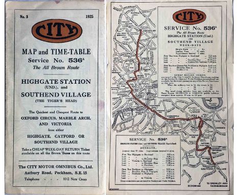
1925 pocket MAP & TIMETABLE for City Motor Omnibus Co service 536A from Highgate Station to Southend Village. City was one of London's most successful independent bus operators and ran from 1923 until takeover by the LPTB in 1934. This fold-out leaflet typifies their professionalism. A few small stains but generally in good, used condition. [1]


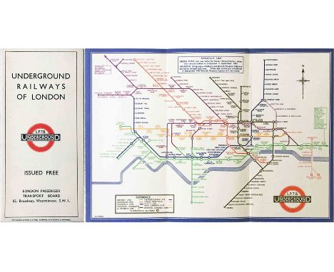
Lot 18
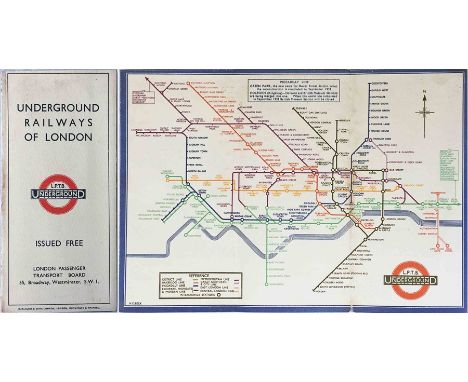
1933 London Underground H C Beck diagrammatic, card POCKET MAP from the first-year series titled 'Underground Railways of London'. This is the edition with no print-code, issued c. August 1933. Refers to re-naming of Dover St station to Green Park and the merger of Holborn and British Museum stations, all in September that year. A lightly-used copy with some age-foxing at one fold but overall still a very good example. [1]

Lot 188
1908 London Underground POCKET MAP issued by the Central London Railway with their own content on the reverse but using the standard London Electric Rlwy 'unified' map. Opens out to 13.5" x 11.5" (34cm x 29cm). In well-used condition with original owner's notes on the cover and map-side. An unusual version. [1]
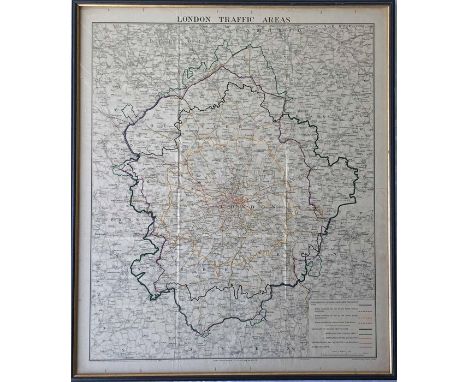
Lot 2
1930s London Transport MAP 'London Traffic Areas' with the London Passenger Traffic, London Traffic and Metropolitan Areas and Metropolitan Police District boundaries shown in different colours, as well as Underground and main-line railways. All superimposed on an Ordnance Survey map. Undated but likely mid-1930s. Framed behind glass. Measures 26" x 30" (66cm x 76cm) in total. In very good condition. [1]

Lot 20
Selection of early London Underground POSTCARDS comprising 2 x c1911 London Underground Railways "Avoid the Weather, Shop in Comfort" with system map on reverse, the first issued for Holdron's Balham, the second for Civil Service Supply Association, plus 2 x 1906 Great Northern, Piccadilly & Brompton Rlwy issues, the first 'Piccadilly Circus', the second 'Interior of Car'. The last is postally used with some creasing, the others are good to very good. [4]

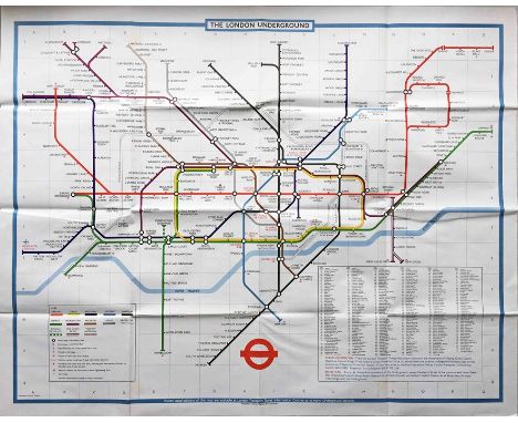
Lot 205
London Underground quad-royal POSTER MAP designed by Paul Garbutt. Undated but shows the original Jubilee Line to Charing Cross and the Piccadilly Line western terminus as Heathrow Central so can be dated to 1979-84. A couple of small, light stains but generally in very good condition. Folded. [1]

Lot 212
1933 London Underground quad-royal POSTER MAP 'Underground Map of London'. Shows the lines superimposed on a street-map with stations depicted with 'bar and circle' motifs. Undated but just pre-LPTB. The Piccadilly Line to Cockfosters is open but Dover Street station has yet to be re-named and British Museum station is still shown with the Holborn interchange not yet open. Some small tears, edge-scuffs and nicks but generally a good example. Folded. [1]

Lot 213
1936 London Transport quad-royal POSTER MAP 'Green Line Coach Routes'. A wonderful map showing the pre-war coach network in its heyday and using the first LT Green Line bullseye logo. These maps would have been posted at Underground stations and in bus shelters but few have survived. Some ageing, a couple of very small losses at fold-corners and minor edge-scuffing but presents very well overall. [1]

Lot 241
1924/25 British Empire Exhibition at Wembley items comprising the official 1924 fold-out PLAN & MAP designed by Kennedy North in a style similar to MacDonald Gill with an Underground map with calligraphed station names and elaborate, colourful illustrations and the 1925 (May-October) 'New Wembley' fold-out GUIDE. Both are used, the latter more so, but generally in good condition. [2]
Lot 289
1933 London Underground H C Beck diagrammatic, card POCKET MAP from the first-year series titled 'Underground Railways of London'. This is the edition with no print-code, issued c. August 1933. Refers to re-naming of Dover St station to Green Park and the merger of Holborn and British Museum stations, all in September that year. A superb example, very close to mint, firm and crisp, with no marks or stains. [1]

Lot 298
Selection (4) of London Transport Metropolitan Line CARRIAGE NOTICES & MAP comprising 1935 'Strolls & Rambles' by Irene Fawkes (card), 1941 'In Air Raids/In the Blackout' (paper, small edge losses), 1945 map of the Aylesbury, Chesham & Watford lines (card) and 1951 'Timetable' by Duke (card). These were displayed in loco-hauled and T-Stock carriages. Measure 24" x 8.25" (61cm x 21cm). The usual damp stains to a greater or lesser extent. [4]
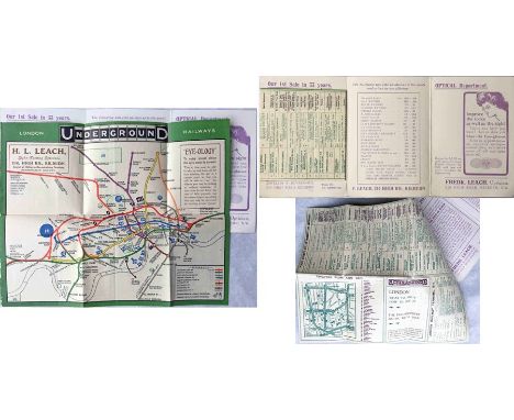
Lot 331
1909 London Underground POCKET MAP. An unusual version produced for F Leach, Jewellers & Opticians of Kilburn with their location and advertisement printed on the map. The map is contained in Leach's 'Book Post' card folder designed for sending in the post. Apart from slight scuffing at one edge, the map is in near-mint condition and the folder is lightly worn but good. A most unusual item, the first we have seen. [1]


Lot 361
1933 London Underground H C Beck diagrammatic, card POCKET MAP from the first-year series titled 'Underground Railways of London'. Issued c.September 1933 and has print reference 33-2791. Shows the escalator connection between Bank and Monument stations. A superb example in just about mint condition, crisp with sharp corners and no marks or stains. [1]


Lot 372
c1908 London Underground POCKET MAP 'London Electric Railways' with the short-lived 'Swift and Sure' sunburst design on the cover. Opens out to 14.5" x 11" (36cm x 28cm). In well-used condition, one short fold-repair but very reasonable overall. Library stamp on cover. An unusual variant. [1]
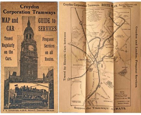
Lot 384
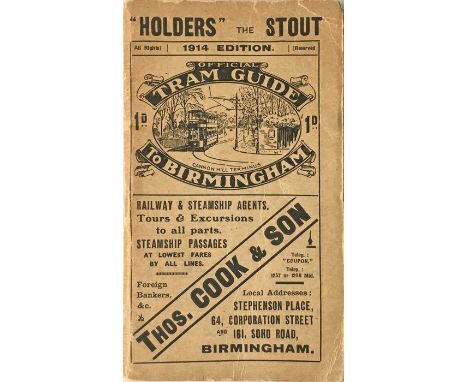
Croydon Corporation Tramways MAP & GUIDE TO CAR SERVICES dated February 1924. Printed on light-brown paper with a cover picture of Croydon Town Hall and an open-top Corporation tramcar. A superb example in excellent condition with just minor signs of wear. One of the best of these we have seen. [1]

Lot 393
1880 District Railway pocket MAP. Opens out to 18" x 11.5" (46" x 29") and can be dated by the opening of the Putney Bridge (Fulham) extension. Shows the Circle Completion Line and the extensions to Wimbledon and Hounslow as under construction or proposed. A very early map of London's first underground railways. A 7" (18cm) tear at one fold, otherwise in very good condition. [1]

Lot 398
1933 London Underground H C Beck diagrammatic, card POCKET MAP from the first-year series titled 'Underground Railways of London'. Issued c.December 1933 and has print reference 33-3636. Shows the escalator connection between Bank and Monument stations. Generally a very good copy, just lightly used. [1]

Lot 403
Selection (12) of 1890s-50s PARLIAMENTARY & TECHNICAL REPORTS on London's transport incl 1892 Electric & Cable Railways (Metropolis), 1901 London Underground Railways (with large fold-out map of tube railways), 1925-26 Public Enquiries under the 1924 London Traffic Act, 1934 River Thames Passenger Transport, 1949 The Willesden Survey, 1951 Engineering Aspects of the Transport Problems of London, 1952 Kingsway Subway Technical Committee. Fascinating historical documents. Condition varies from well-used to good. [12]
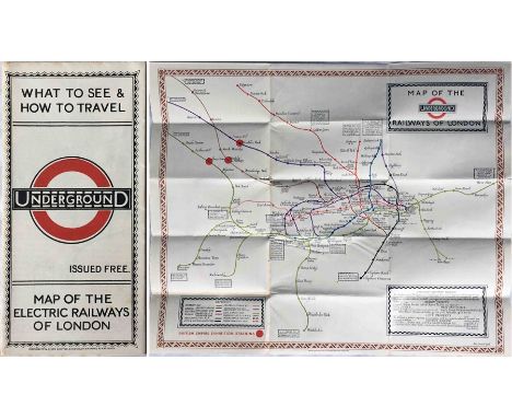
Lot 405
1923 London Underground MAP of the Electric Railways of London "What to see and how to travel". Designed by MacDonald Gill with his distinctive style of calligraphy and map border, this is the issue dated 1/6/23 and the version thereof which shows the British Empire Exhibition stations with red dots. Generally a very good copy, light foxing spots on the spine and rear cover. [1]

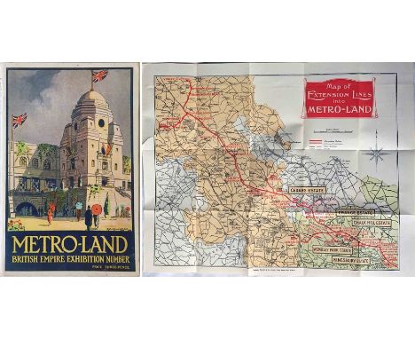
Lot 417
1924 edition of the Metropolitan Railway's METRO-LAND BOOKLET, the British Empire Exhibition Number of the guidebook that ran from 1915-32. This is an original copy, not the recent facsimile, and is complete with fold-out, double-sided map. Very light wear but generally in very good condition, the map has a short tear. [1]

Lot 420
1934 London Underground quad-royal POSTER MAP 'Underground Map of London'. Shows the lines superimposed on a street-map with stations depicted with 'bar and circle' motifs. Issued by the new LPTB with their first 'bullseye' logo but the map continues the format previously used by the Underground Group. Some small partings at the fold-corners but generally a very good example. Folded. [1]
![[Corrected] c1932-33 Metropolitan Railway pocket MAP OF LONDON, the Met's own very attractive map of the Underground which hi](https://cdn.globalauctionplatform.com/ba242a4f-748d-4601-bdb7-aa1400f254b8/cf95d066-a333-4ebf-a32b-aa6e0100afe4/468x382.jpg)
Lot 428
[Corrected] c1932-33 Metropolitan Railway pocket MAP OF LONDON, the Met's own very attractive map of the Underground which highlights their own lines in red and leaves the remainder of the network coloured light blue! The map has print-code M1795/50M and shows the Stanmore line open so will have been issued in late 1932 or early 1933, one of the last before the Met was absorbed into London Transport. In very good condition, no major blemishes. [1]

Lot 430
Two folios dated November 1946 containing DIAGRAMS OF PROPOSED NEW TROLLEY VEHICLE ROUTES submitted by Nottingham Corporation to the 1946/47 Parliamentary Session. One map is duplicated between the folders. Folders measure 30" x 22", contents are in good condition, covers show some wear. [2]
![1861 MAP of the [London] Railways proposed by the Bills of [Parliamentary] Session of 1861 in the Metropolis and its Vicinity](https://cdn.globalauctionplatform.com/ba242a4f-748d-4601-bdb7-aa1400f254b8/2eded8b9-f6b6-4ffe-b4f1-aa5d0151c077/468x382.jpg)
Lot 434
1861 MAP of the [London] Railways proposed by the Bills of [Parliamentary] Session of 1861 in the Metropolis and its Vicinity. In colour, presumably hand-coloured. Shows the first proposed underground and covered-way railways (eg the first section of the Metropolitan Railway) and other fascinating examples like the West End & City Junction Rlwy, the Thames Embankment Rlwy, the London Tramway & Dispatch Company etc etc. Single-sided, opens out to 39" x 26" (99cm x 66cm). Small blemishes but generally in very good condition. [1]

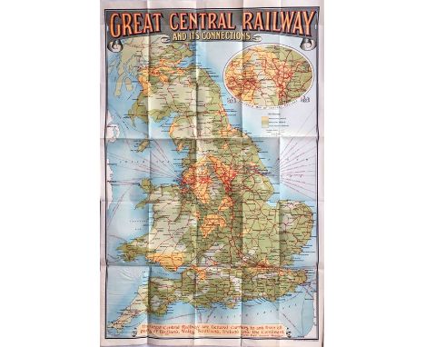
Lot 44
c1910-15 Great Central Railway COLLIERY & INDUSTRIAL MAP (paper). Shows agricultural land, manufacturing areas, proved & concealed coalfields and collieries to which the company's lines have access. Strong colours make this an attractive map. Measures 38" x 29" (97cm x 74cm) and is generally in very good condition. Folded. [1]

Lot 462
1924 Metropolitan Railway CARRIAGE DIAGRAM 'Metropolitan Railway & Connections'. A fascinating card map showing the 'Inner Circle Railway', the East London line, Great Northern & City tube, the Met's services to Hammersmith & Olympia, and connections to all other railways. The note at Wembley Park re the British Empire Exhibition has been changed by sticker, post-BEE, to 'Exhibition Grounds and Stadium'. Measures 24" x 8.25" (61cm x 21cm) and in good condition with minor damp-staining, pin-holes and small corner damage. [1]

Lot 58
1933 London Underground H C Beck diagrammatic, card POCKET MAP from the first-year series titled 'Underground Railways of London'. Issued c.September 1933 and has print reference 33-2791. Shows the escalator connection between Bank and Monument stations. In used condition with a little wear and some very small stains but overall still a good example. [1]
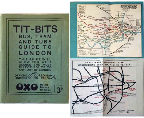
Lot 62
c1925/26 'Stingemore' London Underground MAP (unusual paper issue) with 'Connections with Main Line Termini' on the reverse. Inserted loose into the 'Tit-Bits' Bus, Tram and Tube Guide to London. Map measures 6.5" x 5" (16.5cm x 13cm), folded once as intended and is in excellent condition. The guidebook is in very good condition. [1+1]

Lot 64
1930 MAP 'The Gleneagles Map' of the Heart of Scotland shewing 5,000 square miles of the Highlands & Lowlands around Gleneagles Hotel'. Believed to have been produced by the London, Midland & Scottish Railway, whose crests appear at the foot of the map, whose network is shown in inset and who owned the hotel. A linen-backed map inside hard covers, opens out to 44.5" x 32.5" (113cm x 83cm). In good to very good condition. [1]


Lot 97
1922 London Underground MAP OF THE ELECTRIC RAILWAYS OF LONDON 'What to See & How to Travel' with issue date 1-3-22. Designed by MacDonald Gill with calligraphed station names, the map opens out to 13.5" x 11" (34 x 28cm). Lightly used with a crease on the front cover and a very small stain at the foot of the rear cover but generally a very good copy. [1]

Lot 98
1921 London Underground MAP OF THE ELECTRIC RAILWAYS OF LONDON 'What to See & How to Travel' with issue date 9-3-21. Designed by MacDonald Gill with a blue decorative border and calligraphed station names, the map opens out to 13.5" x 10.5" (34 x 27cm). Lightly used and slightly age-darkened but generally a very good copy. [1]


Lot 877
A quantity of period engravings from travels through Turkey in Asia, The Holy Land, Arabia, Egypt, and other parts of the world by Charles Thompson and printed for J Newbury, London 1767, comprising; A Plan of the City and Country about Jerusalem, A Map of Egypt, A Draught of the City of Jerusalem, The Church of the Holy Sepulcre, An Egyptian Mummy and Pyramids of Egypt, and another, all mounted but unframed
-
109182 item(s)/page