We found 109198 price guide item(s) matching your search
There are 109198 lots that match your search criteria. Subscribe now to get instant access to the full price guide service.
Click here to subscribe- List
- Grid
-
109198 item(s)/page


Lot 159
A 1943 series World War Two (WW2) RAF silk map sheet A & B the front showing map 'A' France, Belgium, Holland, the reverse showing map 'B' German-Swiss Frontier, France and Spain, marked to corners "43 A and 43 B", tag sewn in to another corner 'B. Vinier Hall', 27 x 26in. (68.6 x 66cm.). scarce


Lot 1370
Peter Pan & Wendy Large Book, by J M Barrie, illustrated by Debra McFarlane. Printed on Caxton Wove paper by St Edmundsbury Press, Bury St Edmunds. Book housed in outer case. This large-format Folio edition takes its inspiration from the most beautiful children's books of the Edwardian era. Artist Debra McFarlane's 12 exquisite watercolours illustrate the edition, alongside 23 integrated black-and-white ink drawings including a detailed map of Neverland. With pale blue endpapers printed with a design by the artist, and a silver blocked buckram binding, this is a book to treasure and hand down for generations to come.


Lot 10
Cattle.- Tindall (John) Observations on the Breeding and Management of Neat Cattle, first edition, 3 engraved plates, list of subscribers at end, bookplate of Sir Joseph Radcliffe (offset), occasional slight browning, small damp stain to head of final few leaves, joints starting, [Fussell III p.99], Leeds, 1811 § Sinclair (James) History of Shorthorn Cattle, subscriber's edition, signed by the author on additional title-page, numerous plates, 1 loose, endpapers toned, 1907 § Bates (Cadwallader John) Thomas Bates and the Kirklevington Shorthorns, engraved portrait frontispiece and 5 plates, illustrations, folding map at end, closed tear to head of p.225, hinges cracked, original pictorial cloth, gilt, rubbed with a few ink spots, Newcastle Upon Tyne, 1897, half-titles, occasional light spotting, all but last contemporary half calf, rubbed; and others cattle, v.s. (24)
Lot 185
NO RESERVE Barrie (J. M.).- O'Connor (Daniel S., editor) Peter Pan Keepsake, illustrations, advertisements, original pictorial wrappers, ex-library with discreet blind-stamp to cover, chipping to spine and corners, a little rubbed, house in modern cloth portfolio, 1907 § Barrie (J. M.) Souvenir of the 200th Performance of "The Admirable Crichton", map, colour plates, loosely inserted as issue, paperclip rust mark to corners, original paper portfolio, tape repair to spine verso, lacking flaps, original silk ties, beginning to perish, a little rubbed, housed in modern cloth portfolio, 1902; and others on or by Barrie, including 2 vol. of newspaper clippings, v.s. (10)
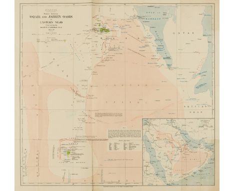
Lot 243
NO RESERVE Middle East.- Cheesman (Major Robert Ernest) Arabia. Routes between 'Oqair and Jabrin Oasis in Eastern Nejd, map of an ornithological expedition in Saudi Arabia, with inset map showing Arabia during the campaign and unification of Saudi Arabia, lithograph printed in colours on wove paper, sheet 505 x 620 mm (19 7/8 x 24 1/4 in), some small repairs to old folds, repaired tear with small loss to centre left edge, Marylebone Public library stamps verso, unframed, 1925
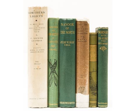
Lot 247
Polar.- Chapman (F. Spencer) Northern Lights, second impression, half-title, frontispiece, plates, 4 folding maps, scattered spotting, original cloth, slight bumping to corners and spine extremities, dust-jacket, small tears and chipping to corners and edges, 1932 § Tyrrell (J. W.) Across the Sub-Arctics of Canada, a Journey of 3,200 miles by Canoe and Snow-shoe throught the Barren Lands, portrait frontispiece, plates and illustrations, folding map, original decorative cloth, gilt, slight bumping to spine extremities, n.d. § Bowden (Rev. John) Norway: Its People, Products, and Institutions, faint staining to title, advertisements at end, original cloth, slight bumping to corners and extremities, 1867; and others similar, 8vo (6).
Lot 253
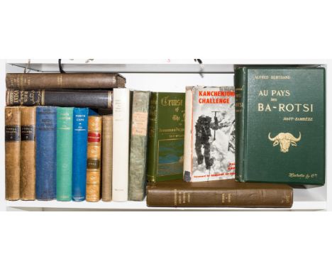
World.- Martin (John) An Account of the Natives of the Tonga Islands, 2 vol., second edition, half-titles, engraved frontispiece and folding map, very light spotting to final ff., original cloth-backed boards, spines a little toned, corners and ends rubbed, 1818 § Christensen (Lars) Such is the Antarctic, first English edition, portrait frontispiece, tear at gutter with tape repair, plates and folding maps, occasional spotting, original cloth, rubbed, 1935 § Bertrand (Alfred) Au Pays des Ba-Rotsi Haut-Zambeze, portrait frontispiece, plates and maps, original cloth, gilt, spine joints and ends light scuffed, 1898; and 12 others travel, including a Samuel Bourne photograph of the Wazir Khan Lahore Mosque, c.1865, v.s., (16)

Lot 256
NO RESERVE World.- Winkles (Henry, artist and engraver) Rigi-Panorama, folding engraved panorama after Wilhelm Ulrich Oppermann, sheet 2120 x 230mm (83 x 9 in), vertical folds as issued, scattered spotting, original cloth-backed boards, lacking ties, rubbed, corners and spine worn, Carlsruhe, Kunst-Verlag [but Carl Ludwig Frommel], [c.1830] § Lear (Edward) Journal of a Landscape Painter in Corsica, wood-engraved plates, map and illustrations, light marking to endpapers, otherwise an internally very clean copy, original cloth, joints split, spine ends chipped with loss, 1870; and a small quantity of others, travel and world, v.s. (sm. qty.)⁂ The second mentioned is probably the the least appreciated and most neglected work by Lear and the last travel book he ever published, mainly due to his difficulties in getting the sketches into a condition where they could be reproduced. The work is still considered one of the best travel books about Corsica.Edward Lear had settled at San Remo, Italy in 1865 and 'in the following winter he went via Venice to Malta, but he found it a dull, unstimulating place to winter. A year later he was in Egypt, keeping a detailed diary of his voyage down the Nile, one of several which he planned, but failed, to publish. In 1867-8 he wintered in Cannes, wondering if France might be the best place to settle, and from there he visited Corsica, the subject of his last, and least commercially successful, travel book, Journal of a Landscape Painter in Corsica' (DNB).
Lot 257
NO RESERVE Britain.- Middleton (Sir Arthur) An Account of Belsay Castle in the Country of Northumberland, photogravure plates, ex-library copy with some stamps, modern boards, Newcastle-Upon-Tyne, for private circulation, 1910 § Hanshall (J. H.) The History of the County Palatine of Chester, additional engraved title, portrait frontispiece and plates, extra-illustrated with 2 water-colours, bookplate to pastedown, some foxing and browning, later green calf-backed cloth, spine ends lightly rubbed, Chester, by John Fletcher, 1817 § Griffith (Samuel Young) New Historical Description of Cheltenham and its Vicinity, first edition, engraved plates and map, bookplate to pastedown, some marginal foxing or water-stains, original boards, rebacked with later calf, extremities worn, Cheltenham, S. Y. Griffith, 1826; and c.25 others, British topography, including some loose maps and 3 estate sale catalogues, v.s. (c.25)

Lot 262
NO RESERVE London.- Andrews (John) Andrews's New and Accurate Map of the Country Thirty Miles round London, third edition, hand-coloured engraved map, folding in sections and mounted on linen, tears and holes at some folds, original marbled slip-case with oval printed label to upper cover, very worn, 8vo, James Heskett, 1813.

Lot 268
London.- Smirke (Sydney) Suggestions for the Architectural Improvement of the Western Part of London, hand-coloured plan and 3 plates, light spotting, hinges weak, original boards, rather rubbed and extremities worn, upper cover working loose, 1834 § Taunt (Henry W.) A New Map of the River Thames, third edition, photographic frontispiece, cut photographs laid down to maps and plans, some hand-colouring, light foxing, one or two maps working loose, advertisements, Oxford, 1878 § Tomlins (Thomas Edlyne) A Perambulation of Islington, author's own copy with his bookplate to pastedown, 2 A.Ls from the author tipped in to front free endpapers, light finger-soiling, original cloth, rubbed, extremities worn, rebacked, 1858; and 15 others, London, v.s. (18)

Lot 28
Laurence (Edward) The Duty of a Steward to his Lord, engraved map and plate, both double-page, woodcut head- & tail-pieces, bookplates of the Earl Fitzwilliam, contemporary calf, rebacked, [Fussell I pp.103-4; Goldsmiths' 6510; Hanson 3677], for John Shuckburgh, 1727 § Mordant (John) The Complete Steward: or, The Duty of a Steward to his Lord...Also a New System of Agriculture and Husbandry, half-title to vol. 2, woodcut illustrations, folding table, bookplate of Sir Gervase Clifton, margins browned at beginning and end, table with a few closed tears to head, tissue repairs to verso, contemporary calf, small loss to spine labels, [Fussell II p.51; Goldsmiths' 9662; Kress 5956; Perkins 1225], for W. Sandby, 1761, first editions, occasional light spotting and finger-soiling, heavier to endpapers, rubbed; and another on stewardship, 8vo & 4to (4)

Lot 45
Young (Arthur) A Tour in Ireland, 2 vol., vol.1 with engraved frontispiece, slightly soiled at head and with short tear to inner margin, just affecting image, the odd spot, contemporary calf, rebacked, spines gilt, [Goldsmiths' 11972], Dublin, George Bonham, 1780; General View of the Agriculture of the County of Essex, 2 vol., engraved frontispieces, that of vol. 1 a hand-coloured map, numerous engraved plates (offset), some scattered spotting and slight browning, vol. 2 with loss to foot of 2G4, affecting some text, modern plum half morocco, spines slightly sunned, 1813, [Fussell III pp.74-5]; and other surveys by the same, 8vo & 4to (9)
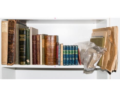
![Britain.- [Agricultural Surveys of the counties of Great Britain], 40 works in 39 vol., most with folding engraved map, many](https://cdn.globalauctionplatform.com/5be86c0a-2c6f-46b3-bbdc-aef600b6a37d/2eb55577-7fbb-497d-be31-aef600bc384e/468x382.jpg)
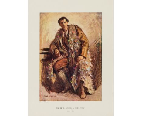
Lot 8
Britain.- [Agricultural Surveys of the counties of Great Britain], 40 works in 39 vol., most with folding engraved map, many hand-coloured, engraved plates, folding tables, some half-titles, offsetting, spotting and browning present in most to varying degrees, contemporary or modern ink ownership names and one or two bookplates, some original boards, these either with spine defective or rebacked, others contemporary or modern calf, these mostly bright and attractive, some with light rubbing or bumping to extremities, others with plain paper wrappers, some trimmed, most Edinburgh and London, 4to & 8vo, 1793-1815; sold not subject to return. ⁂ A comprehensive run.


Lot 1419
Railway - A box of 1940s and 1950s Railway books, maps, and guides including booklets by Ian Allan, British Railways magazine 1953 Coronation number, Train illustrations, folding map of GWR system in paper slip cover. Some later items including Railways in England 1826 and 1827 etc. Also a Single Line token from a railway signal box on the Felixstowe branch. Plus some RMS Queen Mary ephemera.


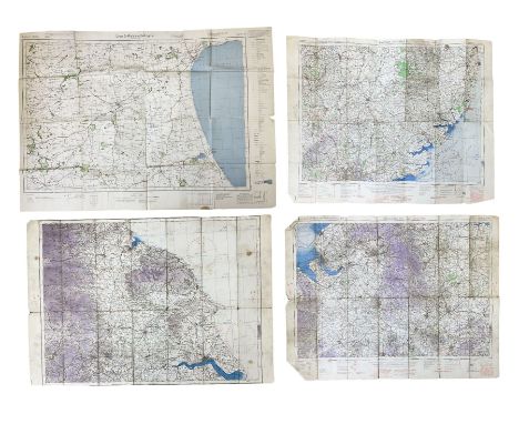
Lot 3052
Three WW2 edition RAF quarter inch to one mile linen backed Ordnance Survey maps of England titled Midlands (N), Eastern Counties (S) and one with text removed showing NE England largest 62 x 81cm; and German O.S. map of East Yorkshire dated 1941 with manuscript Junkers 88 A-5 crew members details verso.Condition Report:Condition is consistent with being well used and folded with some damage to creases.One RAF map of N. E. England has had top and bottom text details removed.
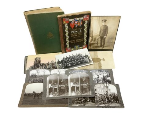
Lot 3079
Twenty-two WW1 real photographic postcards of soldiers including portraits, group shots, Range Training etc; quantity of other WW1 postcards predominantly showing French bomb damage; five WW1 stereoscopic cards including George V visit to Hull munitions factory; W.C. Oates book on The Sherwood Foresters in the Great War; and Hull City Council WW1 Peace Commemorative BookCondition Report:Oates book - well read and lacking one map with three other maps detached but present.Postcards, stereo cards and Hull book all in reasonable condition consistent with age and use.
Lot 3100
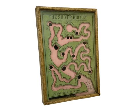
WWI 'The Silver Bullet or the Road to Berlin' ball bearing puzzle game, the stylised printed card map marked with various German towns and hazards on the allied advance to Berlin passing through towns and cities such as Hamburg and Dresden, manufactured by R. Farmer and Son circa 1916, with instructions label verso, in glazed frameCondition Report:The game is generally in reasonably good condition with wear to the frame consistent with age and use and the label on the back is virtually complete but grubby.The playing board has become dislodged from the holding grooves so needs re-fitting for the game to function properly with the single ball bearing.
-
109198 item(s)/page