We found 108737 price guide item(s) matching your search
There are 108737 lots that match your search criteria. Subscribe now to get instant access to the full price guide service.
Click here to subscribe- List
- Grid
-
108737 item(s)/page


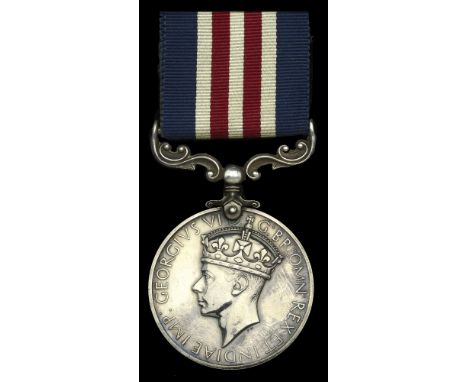
Lot 121
A Second War ‘Gothic Line’ Immediate M.M. awarded to Corporal C. A. W. Lowen, B.E.M., Princess Patricia’s Canadian Light Infantry, for gallantly clearing a path through a heavily sown minefield which enabled the rescue of several stranded comrades, some of whom were wounded, during the course of which he himself was wounded in the hand and arm by an exploding mine Military Medal, G.VI.R. (H.16558 Cpl. C. A. W. Lowen. C. Inf. C.) good very fine £1,200-£1,500 --- B.E.M. (Military) London Gazette 1 January 1943. M.M. London Gazette 8 March 1945. The original recommendation states: ‘H16558 Corporal Charles Albert Willoby Lowen, P.P.C.L.I. Reference Map ITALY, TOMBA di PESARO On the morning of 31 August 1944, Princess Patricia’s Canadian Light Infantry attacked a section of the GOTHIC Line. The objective of C Company was road junction MR 016755. Number 13 Platoon was leading and H.16558 Corporal Charles Albert Willoby LOWEN was in command of a section of this platoon. A heavily sown minefield about six hundred yards in depth lay between the company and its objective. The ground was flat and completely bare except for a large patch of scrub two hundred yards from the right flank. At least three snipers were in this scrub and were sniping the company. The line of advance was covered by enemy artillery fire. Number 13 Platoon reached their objective, but three casualties from mines remained about one hundred yards in the rear. Corporal LOWEN asked for and received permission to go back to the casualties and to clear a lane for stretcher bearers, and the remainder of the company who had provided covering fire for 13 Platoon. Throughout the time he was finding a route back, Corporal LOWEN was sniped at and was under other enemy fire. He was wounded in the left hand and arm by an exploding mine. Notwithstanding these difficulties, Corporal LOWEN continued to clear a lane and finally reached the wounded men and the balance of the company. The coolness and skill of Corporal LOWEN, coupled with his complete disregard of his personal safety, enabled the remainder of the company to reach the objective without casualties and enabled the wounded men to be recovered. His conduct and devotion to duty were an inspiration to all who took part in the operation.’ Sold with heavily redacted copies of his record of service and discharge certificate which confirms award of B.E.M., M.M., 1939-45 Star, Italy Star, France and Germany Star, Defence Medal, and Canadian War Service Medal and Clasp.


Lot 1337
A WWI military silk map, 'To Constantinople from the Dardanelles', stamped 'With best wishes from Manchester Guardian readers', 48 x 60cm, also a period poster 'Allied Air Offensive against Germany up to January 1st 1941Additional InformationThe handkerchief is brown in colour, some spots, staining, poster is mottled, some tears and losses, etc.
Lot 307
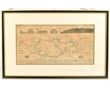
An 18th century engraving, an accurate map of the Matchless Lake of Derwent (situate in the most delightful vale which perhaps ever human I beheld) near Keswick, Cumberland, with hand coloured detailing, 21 x 41cm, framed and glazedAdditional InformationThe paper is foxed and brown throughout and is slightly undulated within the mount. Mount with some specs of dirt and foxing here and there throughout. The frame with light wear.


Lot 309
WENCESLAUS HOLLAR AFTER HOLBEIN; etching, Princess Mary daughter of Henry VIII, 14 x 11cm, framed and glazed, and a late 16th century hand coloured engraved road map being page 123 of an Atlas showing roads to Halifax and Richmond, with a 19th century hand coloured map of Westmoreland and another of Cumberland and a hand coloured engraved book plate (5).Additional InformationAll maps with some foxing and general age browning. The map of Halifax and Richmond is generally much cleaner. Frames with general wear.

Lot 305
JOHN SPEED; an early 17th century and later coloured engraved map, 'The Isle of Man', 1610, image approx 38 x 50cm.Additional InformationGood wide margin, centre fold. Some brown spots of staining - noticeably to the text beneath 'Isle of Man' title. Further small brown stains and foxing and detritus beneath the glass throughout. The map is bordered to the back.

Lot 526
AFTER J RAPKIN "Falkland Islands and Patagonia" a map, visible image 35.5 cm x 25.5 cm, together with AFTER J RAPKIN "East Canada and New Brunswick", coloured engraved map, image size approx 26 cm x 34.5 cm, a copy of "Tombelson's Panoramic Map of The Thames and Medway", two Polar charts and Central chart and another modern copy of a map, "Proportions of The Russian Empire in Eastern and Western Asia - The Aral Sea according to Khanikoff Drawn by Augustus Petermann Engraved by GH Swanston", coloured engraving, 30.5 cm x 45 cm, together with an engraving "An Exact Chart of All the Countries through which Captain Behring travelled from Tobolski Capital of Siberia to the Country of Kamtschatka", image size 18.5 cm x 33.5 cm, "Carte du Spitsberg..... 1758", coloured engraving, image size 22.5 cm x 31 cm and AFTER P. F TARDIEU "Carte Generale de L'Empire de Russie 1878", image size 58 cm x 123 cm


Lot 756
Jenkinson (Henry Irwin), Jenkinson's Practical Guide to Carlisle, Gilsland, Roman Wall and Neighbourhood, small 8vo, gilt cloth, illus with map and frontispiece, 1875; Brown (Paul), The Great Wall of Hadrian, 1st and 2nd editions, 8vo, cloth illus, 1932 and 1936; and three other books and one pamphlet concerning the Roman Wall. (7)


Lot 775
Whellan (T.), Directory and Topography of the County of Durham, with Newcastle-upon-Tyne and other Towns etc., 8vo, half-calf, 1865, (facsimile title page); Parson (William) and White (William), History, Directory, and Gazetteer of the Counties of Durham and Northumberland, 2 vols, 8vo, calf, illus with tables (maps not present); Parson (William) and White (William), History, Directory, and Gazetteer of the Counties of Durham and Northumberland, 2 vols, small 8vo, calf, illus with tables (maps not present); Cooke (George Alexander), Topographical Description of the Country of Durham, forming a county itinerary, 16mo, calf, illus with fold-out map and tables, nd. (6)


Lot 724
Grose (Francis), The Antiquities of England and Wales, vol 1, Northumberland, large 4to, full calf, illus with engravings, printed for S. Hooper 1773; and Grose (Francis), Antiquities of England and Wales: Northumberland (only), 4to, full calf, illus with engravings and hand coloured map, 1787. (2)


Lot 702
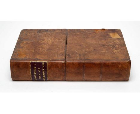
Fryer (John & Sons) Map of the County of Northumberland from an actual survey, published in the year 1820, engraved by M. Lambert, Newcastle upon Tyne, with hand-colouring, linen-backed in three parts, folded and enclosed in book-pattern box case; together with An Alphabetical Index to Fryer's Map, Newcastle upon Tyne 1822, and A List of the Wards, Divisions, Parishes and Constabularies in Northumberland, Alnwick 1817, 2 vols. in 1, half-calf binding, formerly the property of T.W. Beaumont Esq.

Lot 722
Bates (Cadwallader J.), Popular County Histories: Northumberland, 8vo, half calf, 1895, with the bookplate of Fred Raimes, Hartburn Lodge, Durham; Whellam (William), History of Northumberland etc., 8vo, half calf, 1855; and Hodgson (The Rev.), A Topographical and Historical Description of Northumberland, 8vo, quarter-calf and marble boards, illus with engravings and fold-out map. (3)

Lot 751
Hutton (William), The History of the Roman Wall, 8vo, original boards, illus with fold-out map and plates, 2nd edition 1813; a History of the Picts or Romano-British Wall...taken during a pilgrimage taken on that part of the island, 1849, 8vo, half calf, illus, George Bell 1849; and Simpson (F. Gerald), Water Mills and Military Works on Hadrian's Wall, 4to, cloth, illus with fold-out charts, limited edition 400 copies, Kendal 1976, with dw. (3)
Lot 701
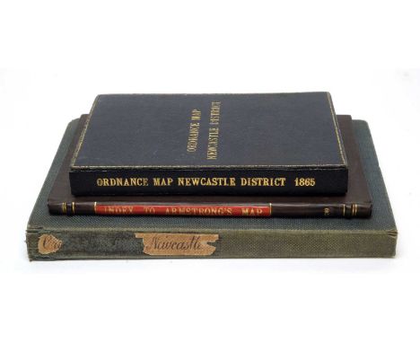
Armstrong (Lt. Andrew & Son) A Map of Northumberland 1769, engraved by Thomas Kitchin, with hand-colouring, linen backed in three sections, folded and contained in book-patterned case, scale 1in. to the mile; together with A Companion to Armstrong's Map of Northumberland, 8vo, marbled boards, 1769: the map bearing the bookplate of Sir Horace St. Paul.

Lot 713
Baillie (J.), An Impartial History of Newcastle upon Tyne and its Vicinity, 8vo, full calf, illus with fold-out map and engravings, Newcastle 1801; A Popular History of Newcastle upon Tyne and Gateshead, complied by the best authorities, 8vo, half calf and marbled boards, Newcastle 1862; The Newcastle Remembrancer and Freeman's pocket companion, 8vo, marbled boards, new edition Newcastle 1817; and Burgess (A.), The Newcastle Freeman's pocket companion, small 8vo, half calf with marbled boards, Gateshead 1808, with the bookplates of Matthew Mckey. (4)

Lot 138
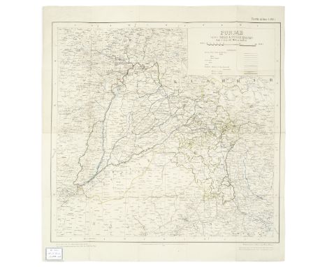
MAPS - COLLECTIONTourist Map Jammu & Kashmir State... Printed at the Request of the Chief Conservator of Forests, heliozincographed, some lakes and waterways hand-coloured in blue, one corner missing (not touching map area), a few small tears at folds, c.1390 x 1115mm., [1939]--Quetta and Surrounding Country, colour-printed, laid on linen, stamped 'For Official Use Only. Restricted' in red, c.1120 x 820mm., Printed under direction of Brigadier H.J. Couchman, Surveyor General of India, March 1944--Punjab (Also Delhi & Punjab States)... New Edition..., heliozincographed map printed in colours, backed on linen, Ex libris plate of R.A. Scoales in corner, c.610 x 570mm., Calcutta, Survey of India, 1928, all folding maps; and c. 24 other folding, mostly pre-1949 maps of India, including Multan City, Rawalpindi, Lucknow, Delhi, Lahore, etc. (quantity)This lot is subject to the following lot symbols: •• Zero rated for VAT, no VAT will be added to the Hammer Price or the Buyer's Premium.For further information on this lot please visit Bonhams.com
![JOHNSTONE (J.W.D.)Gwalior 1905, inscribed 'From M.[aharajah] S.[cindia] 1908', 24 photogravure plates, dampstain to spine,](https://cdn.globalauctionplatform.com/06eec964-5eaa-4c09-8fc4-ad8a00c41dfb/b55fbda9-594f-4ad0-854f-ad8a00c74b1b/468x382.jpg)
Lot 104
JOHNSTONE (J.W.D.)Gwalior 1905, inscribed 'From M.[aharajah] S.[cindia] 1908', 24 photogravure plates, dampstain to spine, J. & E. Bumpus, [1907]--Marriage Album ['Souvenir of June 24 1925 with love from Chemmajammannni'], 2 gelatin silver prints of the festivities, original wrappers, [1925]--The Historical Record of the Imperial Visit to India 1911, numerous photographic plates, spine dampstained, John Murray, 1914--RAFIULLAH (MOHAMMAD) Gwalior's Part in the War, upwards of 60 photogravure plates, paint splash on spine, Published by Authority, 1920--Pictures. Government House, Madras, 16 photogravure plates, inscribed 'For Sir Hugh Daly's bookshelf, 10 January 1916', [1916]--SRIKANTAIYA (S.) The Scri Krishmaraja Silver Jubilee Souvenir, numerous photographic illustrations, folding table, Bangalore, Trades Publicity Co., 1927--RAMAKRISHNA ROW (B., Place Controller, Mysore) Bangalore Past & Present, AUTHOR'S PRESENTATION COPY INSCRIBED TO LADY DALY, Mysore, G.T.A. Press, 1916--PRESTON (SIDNEY, of Ajmeer College) Lecture [on the subject of irrigation], AUTHOR'S PRESENTATION COPY TO HUGH DALY, 8 folding hand-coloured lithographed plates and one map of India 'showing the distribution of the drainage... by the rivers flowing from the Himalayas', all loosely inserted, publisher's wrappers, Allahabad, Pioneer Press, 1908--The Kings Emperor and his Dominions. Souvenir of the Coronation Durbar of H.I.M. George V... 1911, numerous photographic illustrations, original red calf, g.e., lettered in gilt, Burrough's Wellcome & Co., [1911]--Coronation Durbar. Delhi 1911. Official Directory with Maps, 2 folding maps in pocket at end, Calcutta, Government Printing, 1911--Delhi Coronation Durbar December 1911, 3 folding maps in pocket at end, photographic illustrations, publisher's gilt printed boards, soiled, Army and Navy Co-operative, 1911, unless otherwise mentioned publisher's cloth, rubbed, 8vo and 4to; and 2 other books, and three original watercolour portrait studies of Indian subjects including soldier and road sweeper by M.A. Azeez, 350 x 140mm., signed and dated 1915 and 1916 (group)Footnotes:Provenance: Sir Hugh Daly (1860-1939), Agent to the Governor-General in Central India (1905-1910); by family descent to present owner.This lot is subject to the following lot symbols: •• Zero rated for VAT, no VAT will be added to the Hammer Price or the Buyer's Premium.For further information on this lot please visit Bonhams.com
Lot 165
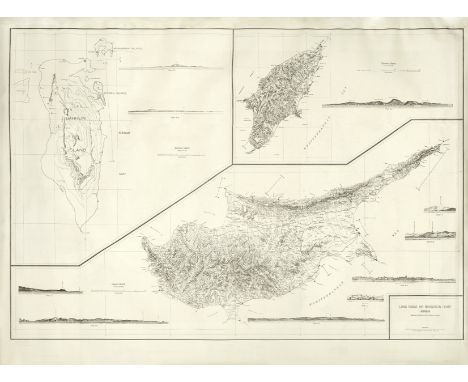
ARABIA - WORLD WAR II MILITARY MAPLong Range Air Navigation Chart. Arabia, Bahrein, Rhodes, and Cyprus Islands, printed map, captioned 'Restricted', centred on Basra, with information on 'annual magnetic change increase', Range stations 'that can be used by aircraft', 'standard broadcasting stations', marine lights, etc. printed in purple, large maps of Cyprus (with six sectional views), Bahrain and Rhodes on the verso, light dampstain in upper blank margin, sheet 970 x 1310mm., Compiled for the U.S. Army Air Forces, by the Army Air Forces... Aeronautical Data, April 1942Footnotes:A scarce chart issued for use by the U.S. Army Air Force during the Second World War. Marked 'Restricted' for the use of U.S. officers, the chart was produced 'for use in day light' and with the warning that due to wartime conditions 'lights, radio facilities, and other aides to navigation may be changed or discontinued without notice'.This lot is subject to the following lot symbols: •• Zero rated for VAT, no VAT will be added to the Hammer Price or the Buyer's Premium.For further information on this lot please visit Bonhams.com

Lot 2
PACIFIC OCEANORTELIUS (ABRAHAM) Maris Pacifici (quod vulgo Mar del Zur) cum regionibus circumiacentibus, insulisque in eodem passim sparsis, novissima descriptio, double-page hand-coloured engraved map, 2 galleons in the sea area, 2 cartouches (one with the date of 1589), Latin text on verso, wide borders, a few very small tears in upper blank border [Burden 74], 345 x 500mm., [Antwerp], 1589 [but c.1609]Footnotes:'One of the most important maps that appeared in the Ortelius atlas, this was the first printed map to be devoted to the Pacific ocean, the discovery of which is remembered by the depiction, with legend, of Ferdinand Magellan's ship the Victoria... one of Ortelius' most desirable maps' (Burden, Mapping of America, 74).This lot is subject to the following lot symbols: •• Zero rated for VAT, no VAT will be added to the Hammer Price or the Buyer's Premium.For further information on this lot please visit Bonhams.com

Lot 154
SOUTH AFRICAThe Cape of Good Hope Calendar, and Agriculturist's Guide: Containing a Correct Account of All the Public Offices, Military Forces, and other Establishments in that Colony. Together with a Brief Description of its Soil, Agriculture, and Commerce. Intended for the Use of Persons who may become Settlers, FIRST EDITION, lacking the map, light soiling and browning, untrimmed in publisher's boards, rebacked, printed title label on spine, covers stained and worn at corners, T. and J. Allman, and sold by Baldwin, Cradock and Joy, 1819--SEMPLE (ROBERT) Walks and Sketches at the Cape of Good Hope; to which is Subjoined, a Journey from Cape Town to Blettenberg's Bay, FIRST EDITION, half-title, a little very light foxing, bookpate of Sir Joseph Radcliffe, contemporary half calf, spine a little worn [Mendelssohn II p.304.], C. & R. Baldwin, 1803--STOUT (BENJAMIN) Cape of Good Hope and its Dependences, bookplate of Sir Michael R. Shaw Stewart, untrimmed in publisher's boards, rebacked, soiled, cloth portfolio and slipcase [Mendelssohn II pp.445- 446], Edwards and Knibb, 1820, 8vo (3)This lot is subject to the following lot symbols: •• Zero rated for VAT, no VAT will be added to the Hammer Price or the Buyer's Premium.For further information on this lot please visit Bonhams.com

Lot 218
SHACKLETON (ERNEST HENRY)South. The Story of Shackleton's Last Expedition 191-1917, FIRST EDITION, with errata slip tipped in, half-title, colour frontispiece, 87 photographic plates on 44 leaves (one double-page), folding map, publisher's pictorial blue cloth, upper cover lettered and stamped with image of 'Endurance' in silver gilt, rubbed, gilt dulled [Spence 1107; Taurus 105], 8vo, William Heinemann, 1919Footnotes:Provenance: Ralph Dickinson, armorial bookplate.This lot is subject to the following lot symbols: •• Zero rated for VAT, no VAT will be added to the Hammer Price or the Buyer's Premium.For further information on this lot please visit Bonhams.com

Lot 129
James Manson (British, 1791-1862)Six views in the Himalayas signed 'JManson' (one lower right, the others lower left)watercolour29.3 x 41.6cm (11 1/2 x 16 3/8in). (6)mounted but unframedFootnotes:From 1823-1828, Manson accompanied his brother-in-law, James Herbert, on a mineral survey of the Himalayas. Herbert was the superintendent of this geological survey and Manson assisted with the creation of a map of the region. As it is unclear whether Manson visited this area again, it is believed that these works were created at this time.For further information on this lot please visit Bonhams.com
![JAPANESE ANTARCTIC EXPEDITION 1910-1912[SHIRASE (NOBU] Nankyoku-ki, FIRST EDITION, FIRST PRINTING, 4 coloured plates, 33 ful](https://cdn.globalauctionplatform.com/06eec964-5eaa-4c09-8fc4-ad8a00c41dfb/eb59076a-5afa-4b3a-b48a-ad8a00cada6d/468x382.jpg)
Lot 212
JAPANESE ANTARCTIC EXPEDITION 1910-1912[SHIRASE (NOBU] Nankyoku-ki, FIRST EDITION, FIRST PRINTING, 4 coloured plates, 33 full-page photographic illustrations (one double-page), one folding colour-printed map, illustrations in the text, publisher's red-printed colophon mounted on card (as issued), toning to a few leaves of text but generally clean, publisher's dark blue cloth, blindstamped pictorial decoration and silver gilt lettering on upper cover, silver gilt lettering on spine (rubbed), joints neatly repaired [Rosove 309.A1a ('rare'); Ross 1.5.1 ('rare')], 8vo, Tokyo, Seikô Zasshisha, 15 December 1913Footnotes:RARE first edition, first printing of the 'official account' of the Japanese Antarctic Expedition 1910-1912. Based upon the journals and logs of team leader Nobu Shirase and other exhibition members it also includes information on the scientific findings.This lot is subject to the following lot symbols: •• Zero rated for VAT, no VAT will be added to the Hammer Price or the Buyer's Premium.For further information on this lot please visit Bonhams.com
Lot 91
KASHMIRCOLE (HENRY HARDY) Illustrations of Ancient Buildings in Kashmir. Prepared under the Authority of the Secretary of State for India in Council from Photographs, Plans and Drawings taken by Order of the Government of India, FIRST EDITION, 43 mounted carbon autotype prints (numbered 1-44), 14 plates, one colour-printed lithographed map ('Skeleton Map of Kashmir') by W. Griggs after Cole, publisher's orange cloth gilt, g.e., rebacked [cf. Gernsheim 485, recording 2 editions of that year], folio (335 x 245mm.), W.H. Allen, Publishers to the India Museum, 1869Footnotes:The fine photographs were taken by John Burke (1843-1900), a commercial photographer operating from Murree and Peshawar. He accompanied, alongside two 'native surveyors, Thakoor Dass and Habeeb-oo-lah', Cole's expedition to the Kashmir Valley in October 1868 to survey the great pre-Islamic temples scattered through the region.This lot is subject to the following lot symbols: •• Zero rated for VAT, no VAT will be added to the Hammer Price or the Buyer's Premium.For further information on this lot please visit Bonhams.com
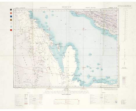
Lot 166
PERSIAN GULF - WORLD WAR II MILITARY MAPSHofuf; Bandar 'Abbas, a pair of military maps of the Persian Gulf, from the desert beyond Hofuf towards Riyadh in the West, to Bent and Fanouj in Eastern Iran, and Kerman Province, Iran in the North to the Qatar/Saudi Arabian border in the South, colour printed, each captioned 'Restricted', with references to terrain, oil wells and pipelines, transport network, an Arabic glossary (also Farsi glossary on Bandar 'Abbas map), and (in red) 'Reference to Air Information as Supplied by H.Q. R.A.F... 1944', the Bandar 'Abbas map with 'Flight Line Overprint', light fold creases, sheet size 645 x 815mm., 'Reprinted by 17 Map Reproduction Section, R.E., Sept. 1944' (2)Footnotes:Scarce World War II military maps of the Persian Gulf, both marked 'Restricted', overprinted with Royal Air Force information on functional and abandoned airfields, landing grounds, etc., and flight lines, in addition to detailed information on local terrains, cities, tribal names, oil wells and pipelines, etc.This lot is subject to the following lot symbols: •• Zero rated for VAT, no VAT will be added to the Hammer Price or the Buyer's Premium.For further information on this lot please visit Bonhams.com
Lot 103
KIRKPATRICK ((WILLIAM)An Account of the Kingdom of Nepaul, Being the Substance of Observations Made During a Mission to that Country, in the Year 1793, FIRST EDITION, half-title, engraved vignette on title, 14 engraved plates (one hand-coloured), large folding engraved map (short tear), spotting, contemporary half calf, defective, covers detached, 4to, William Miller, 1811Footnotes:Provenance: Sir Hugh Daly (1860-1939), Agent to the Governor-General in Central India (1905-1910), and Resident of Mysore (1910-1916), bookplate.This lot is subject to the following lot symbols: •• Zero rated for VAT, no VAT will be added to the Hammer Price or the Buyer's Premium.For further information on this lot please visit Bonhams.com


Lot 485
An excellent collection of original items relating to the 'Festival of the Tenth Summer', in July 1986. To include: Cummins Ten postcard set, 'The Book', 'The Map', Peter Saville 'The Numbers' postcard set, 'The Set' 10 mini posters still in tube each 25 x 20" (NM condition), 'The Poster' G-Mex (20 x 30") and 'The Kitchen' poster, both NM condition.


Lot 52
Thomas Kitchin : Map of Northumberland, steel engraving, with hand colouring, with margins, 21 cm x 27 cm, together with another hand coloured map (steel engraved bookplate) showing Northumberland and a colour print after David Roberts depicting The Temple of Nubia, all three parts framed. (3)


Lot 404
A dissected globe,Edward Mogg; London, 18124-inch diameter card terrestrial globe, comprising pieces of printed card, slotting together to form the appearance of a globe, two of the upright sections forming two hemispheres of a world map, with further horizontal spheres (Equator & Tropic of cancer missing) under a glass dome on a stand 14cm wide, 19cm high (5 1/2in wide, 7in high) For further information on this lot please visit Bonhams.com
-
108737 item(s)/page