We found 109198 price guide item(s) matching your search

Refine your search

Year

Filter by Price Range
  • List
  • Grid
  • 109198 item(s)
    /page

Lot 524

Robert Morden, `Herefordshire`, a hand coloured engraved map, and a map of Kent

Lot 422

ROBERT MORDEN, An antique County Map of Westmorland

Lot 423

CHRISTOPHER SAXTON. ` The Countie of Radnor described`, engraved map , hand coloured, published by John Speede, sold by John Sudbury and George Humbell`15 x 20 in

Lot 148

Coloured map Gloucestershire and another, Nottinghamshire (2)

Lot 111

A coloured and tinted map of Buckinghamshire by JOHN SPEED, Sudbury & Humble edition, 16.5 x 20.5, glazed to the rear

Lot 112

A coloured and tinted map of Berkshire featuring Windsor Castle by JOHN SPEED, Bassett & Chiswell edition, 16 x 21, glazed to the rear

Lot 113

A coloured and tinted map of Oxfordshire by SAXTON & HOLE, 10.5 x 11.5 with wide border

Lot 114

A coloured print of a map of Warwickshire and Leicestershire by SAXTON, 19.5 X 24.5

Lot 153

A 19th century map, The Shetland Isles, published by Thomas Brown

Lot 154

An 18th century map of the County Palatine of Lancaster, after Herman Moll

Lot 155

A 17th century map of Wiltshire, after Speede/Keere, circa 1666

Lot 158

A 18th century map of Westmorland after Robert Morden

Lot 159

A 18th century map of Westmorland after John Speede including inset for Kendale

Lot 209

After John Speed, Northamptonshire, a hand-coloured map, bears date 1610, framed.

Lot 219

After John Speed, Huntington, a hand-coloured map, framed.

Lot 223

After John Speed, Rutlandshire, a hand-coloured map, framed.

Lot 250

After Kirkland, "The Manor of Carleton, Northamptonshire", hand-coloured, map of Buckinghamshire, map of Oxfordshire, (3).

Lot 447

Map of Lincolnshire dated 1627 by Pieter Van Keere

Lot 476

Framed hand coloured map of Lincolnshire dated 1610

Lot 637

A map of Kent, 1835, together with a map of Worcestershire and a colour-printed reproduction map of England and Wales, 1579, all framed,

Lot 47

17th century hand-coloured map engraving of Hampshire engraved by Hole after Norden, dated 1607, 29 x 32 cm

Lot 129

Eight old map engravings of Hampshire including a Robert Morden example (unmounted) to/w eight other unframed map engravings (16)

Lot 130

Nine small old map engravings of Hampshire (9)

Lot 131

H. Moll - Map engraving of Hampshire to/w two others (3)

Lot 124

Various decorative pictures and prints including birds after Oudubon, a map of Derbyshire, two prints after Chippendale of Beds etc.

Lot 4

`Wallis`s New Plan of London & Westminster`, 1799, folding map with list of Hackney coach fares housed in pictorial card sleeve dates 1800.

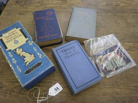
Lot 54

A cased Bartholomews six inch Motoring Map of Great Britain, assorted Dunlop maps etc.

Lot 750

An antique map of Rutland, unframed

Lot 1464

A 1938 Kelly`s London Post Office Directory with a directory map

Lot 2092

A Robert Morden Map of the County Palatine of Lancaster, circa 1695/1727. Nicely hand coloured, in good condition.

Lot 2094

An Original Christopher Saxton, Robert Vaughan Map of Brecknoc (Brecon) circa 1610/1637, nicely hand coloured, framed and glazed (The Robert Vaughan printing rarely Seen).

Lot 2095

An Original Christopher Saxton, William Kip Map of Brecknoc. Circa 1610/1637, nicely hand coloured, framed and glazed.

Lot 2096

An Original William Camden Map of Pembroke, engraved by George Owen, 1st Edition, 1607 Latin text verso. Uncoloured.

Lot 1151

A reproduction Map of Shropshire

Lot 1304

A hardbound Volume The British Dominions Year Book 1916 profusely illustrated and with fold out maps etc. a Geographia Map of England & Wales on linen.

Lot 1308

A circa 1934 hardbound volume History of Rome stamped in gold to the spine `Pinnocks Goldsmith`s Rome` with illustrations & fold-out f=map.

Lot 1407

A nicely framed Map `Glocestria Dvcatvs, cum Monvmethensi Comitatu Glocestershire & Monmouthshire` with ten heraldic symbols to the upper right. Signs of a central fold and slight loss in upper area from adhesions. A version of a map by Jan Jansson of 1646. 16 1/2`` x 20 1/2`` approx.

Lot 13

Four books - The New Dover Guide containing a plan of the town, a concise account of Dover Castle and a description of the villages near Dover, published in 1830. The Isle Of Thanet And The Cinque Ports by E W Brayley being volume 2, published in 1818. Colbran`s New Guide For Tunbridge Wells illustrated and edited by James Phippen, published in London and A Picture Of Margate And Its Vicinity by W C Oulton illustrated with a map and twenty views, published in London 1820.

Lot 15

Four books - Rochester And Chatham With Their Surroundings with ordnance map being a home and handbook no.9. The Saxon Dynasty Of Kent And Illustrated Pedigree Of The Kentish Kings by the Rev. R C Jenkins. The Old Inns Of Kent by D C Maynard and The Churches Of Kent by the late Sir Stephen R Glynne, with illustrations, published in London 1877.

Lot 248

A 19c linen rolled wall map of Ireland published by James Wyld Geographer To The Queen, Charring Cross East, London, with reference to railways completed and others proposed, the map 59"w, 72"h.

Lot 172

A mixed lot to include a cast iron "The Young Nigger Bank" money box, an Anchor Stone puzzle box, three wooden novelty treen shoes, a pair of cased gentleman`s spectacles, map, coins, etc

Lot 416

AFTER LIEUT. HENRY ROBERTS "General Chart: Exhibiting the discoveries made by Capt.n James Cook in this and his two preceding voyages; with the tracks of the ships under his command", a black and white engraved map

Lot 240

An early 19th Century map of Europe in ebonised glazed frame. 61cm x 100cm.

Lot 74

SAYER, ROBERT (act.1750-1780), New Map of the Counties of Cumberland and Westmoreland, 1760, coloured, framed, 70cm x 52cm, a Robert Morden coloured map of Herefordshire, framed, 38cm x 42cm, and a Morden map of Staffordshire, 42cm x 35cm (3)

Lot 303

Chaillu The Land of the Midnight Sun 1881 2 vol. first edition linen-backed colour folding map at rear of vol.I (slightly torn) engraved plates illustrations occasional foxing later half crimson calf t.e.g. slightly rubbed and scuffed 8vo 1881. ***Paul Du Chaillu (1835-1903) is best-known as an African explorer. He spent his early years on the West Coast of Africa where his father worked. This work was written when he settled in America to lecture and write about Africa..

Lot 309

Kingsley (Mary H.) Travels in West Africa 1897 Congo Français Corisco and Cameroons plates mostly photographic original cloth a little rubbed spine slightly faded 1897 § Moore (Decima) and Major F. G. Guggisberg We Two in West Africa frontispiece folding map illustrations original cloth rubbed & faded 1909 both foxed 8vo(2)

Lot 315

Bartlett Narrative...Texas New Mexico 1854 2 vol. first edition folding map and 16 tinted lithographed plates folding map with a few small holes some marginal water-staining occasional spotting or light foxing contemporary polished calf rebacked in buckram preserving original backstrips water-stained [Howes B201; Sabin 3746] 8vo 1854.

Lot 316

Brigham Guatemala: the Land of the Quetzal plates and illustrations 3 folding maps hinges weak 1887 § Payne (Will) and C. T. W. Wilson. Missionary Pioneering in Bolivia plates foxed and browned n.d. § Gallenga (A.) South America folding map (torn) catalogue at end ink signatures at head of title 1880 occasional spotting original cloth extremities rubbed the first with upper joint splitting the last soiled; and another South America 8vo(4)

Lot 317

Hall Appleton`s...United States & Canada folding maps New York 1867 § The Englishman`s Illustrated Guide Book to the United States and Canada folding coloured map illustrations g.e. 1874 § Godfrey (Edward K.) The Island of Nantucket maps Boston 1882; and two other United States and Canada Guides 8vo(5)

Lot 318

Hancock An Emigrant`s Five Years...America presentation copy from the author folding frontispiece map 3pp. advertisements at start and end map torn with no loss original cloth spine gilt 2 small red stains to lower cover spine ends and corners slighty frayed rubbed [Howes H153] 8vo 1860.

Lot 326

Perrin Du Lac (François Marie) Voyage dans les deu first edition lacking map and plate damp-staining and library stamp to title original grey wrappers uncut worn and repaired with tape some loss 8vo Lyons 1805.

Lot 336

Wimpffen A Voyage to Saint Domingo 1788 translated by J. Wright first English edition half-title folding engraved map hand-coloured in outline very short repaired tear just within printed area offsetting engraved bookplate of R. Edward Brenan Dungarvan contemporary tree calf spine gilt chip to head of spine joints starting but holding firm scarce 8vo for T.Cadell Junior and W.Davies 1817.

Lot 340

Sturt Expeditions...Southern Australia 2 vol. first edition half-titles 13 lithographed plates 4 hand-coloured 1 map only (of 2 lacking the large folding map) without advertisements bookplate of R.Edward Brenan of Dungarvan with his ownership inscription on half-title of vol.1 some foxing and soiling original cloth spines faded spine ends and corners worn [Ferguson 1704] 8vo 1833.

Lot 349

Lear Journal of a painter in Corsica first edition map illustrations occasional foxing original cloth neatly rebacked preserving original spine very slightly rubbed large 8vo 1870.

Lot 350

Corsica.- Lear (E) Journal... first edition map illustrations Clement Shorter`s copy with his bookplate contemporary morocco gilt detached at upper joint edges rubbed g.e. large 8vo 1870.

Lot 355

Norden Travels in Egypt and Nubia 1757 translated by Dr. Peter Templeman 2 vol. in 1 engraved folding frontispiece map and 6 plates 4pp. advertisements at end some offsetting engraved bookplate of Michael Kearney and his ink signature to title contemporary speckled calf upper joint starting but holding firm slight chipping to foot of spine rubbed especially spine still a good copy 8vo for Lockyer Davis and Charles Reymers 1757.

Lot 371

Hendschel (U.) Post und Reise-Karte von Deutschlan engraved map original outline hand-colouring dissected and linen-backed 1085 x 1245mm. original cloth slip-case with French and German labels worn Frankfurt J.Back & C.Sauter 1851; and another German folding map 8vo(2)

Lot 374

Wilmans. Mahlerische Ansichten des Rheins 3 parts in 1 32 engraved plates and folding map contemporary diced calf gilt rubbed 8vo Frankfurt am Main 1806.

Lot 380

Birdwood. The Industrial Arts of India folding map plates occasional foxing original cloth gilt g.e. soiled 8vo [c.1880].

Lot 385

Markham Shooting in the Himalayas 1854 first edition wood-engraved additional pictorial title tinted lithographed frontispiece and 7 plates folding map wood-engraved illustrations map with some foxing light marginal water-staining to plates a few other marks contemporary dark green half morocco spine gilt very short split to head of upper joint rubbed [Czech Asian p.134] 1854.

Loading...Loading...
  • 109198 item(s)
    /page

Recently Viewed Lots