We found 109182 price guide item(s) matching your search

Refine your search

Year

Filter by Price Range
  • List
  • Grid
  • 109182 item(s)
    /page

Lot 2506

Original vintage travel poster advertising KLM: To All Points West ... Everything Points to KLM Royal Dutch Airlines. Fun image of a plane flying over various images: a tourist leaning back to take a photo of a tall building, another on a lake holding up his camera in a small boat with mountains in the background, a Canadian mounted policeman ("Mountie") on his horse, a pair of tourists with a map looking through a telescope and a pair of acrobats. Artwork by the illustrator Emile Brumsteede (Mile; 1911-1962). Printed in Netherlands. Good condition, light soiling, repaired tears. County: Holland, year of printing:1954, designer: Mile (Emile Brumsteede), size (cm): 101x63

Lot 2602

Original vintage map poster of the capital of England -Historical Map of London - by the notable cartographer and pictorial map artist Leslie George Bullock (1895-1971) featuring colourful and detailed illustrations including notable landmarks, parks, railway lines, historical buildings, people and workers in different period dress (industrial workers, a highwayman on a horse, printing and weaving, brewing and shipping, knights and soldiers, Canterbury pilgrims, merchants, actors, a friar, Yeoman of the Guard, dockers etc.) and a key showing the time period from the Roman to the Victorian and 20th century periods for the historical sites and features, the line of the City Wall and significant events, framed by various coats of arms with the heading above for the Arms of the City of London and of the Guilds of London with the motto Domine Dirige Nos (Lord Guide Us), and the Metropolitan Boroughs AD 1899-1965, London County Council and Greater London Council, Port of London Authority, Westminster Abbey and London University etc. below and in the decorative corners. Printed by John Bartholomew and Son. Horizontal. Fair condition, creasing, tears, cut edges, pinholes, stains, small paper loss. County: UK, year of printing:1969, designer: LG Bullock, size (cm): 100x67

Lot 2615

Original vintage Road map of the Cape Peninsula, Malmesbury, Paarl & Gordons Bay Districts. Drawn by A.I Bannerman from the best available sources of information. Presented by the Vacuum oil company of South Africa Limited. Adverts for Pegasus motor spirit and Mobiloil. Fair condition, tears, creasing. Vacuum Oil Company was an American oil company known for its Gargoyle 600-W Steam Cylinder Oil. Vacuum Oil merged with the Standard Oil Co of New York, commonly known as Socony Oil to form Socony-Vacuum Oil Company, and is now a part of ExxonMobil. County: South Africa, year of printing:1920s, designer: A I Bannerman, size (cm): 70x49

Lot 4501

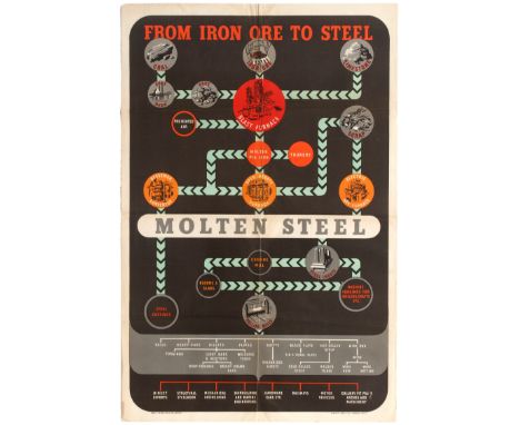
Set of 5 propaganda and educational posters issued in the UK. 1. Original vintage educational poster issued by the British Iron and Steel Federation featuring a illustrated chart presenting the steelmaking process, from iron ore to steel. Good condition, folded as issued, creases. County: UK, year of printing:1950s, designer: Unknown, size (cm): 76x50.5; 2. Original vintage information poster issued by the British Iron & Steel Federation. Good condition, folded as issued, faint creases, small tears in margins. County: UK, year of printing:1940s, designer: Unknown, size (cm): 69x105 (Horizontal); 3. Original vintage propaganda poster prepared for His Majesty's Government by the Economic Information Units and the Central Office of Information, this poster features various black and white photographs illustrating different areas of investments in Britain. Great image of the Battersea Power Station on top of the poster. Good condition, minor tears and creases in margins. County: UK, year of printing:1951, designer: Unknown, size (cm): 76x50.5; 4. Original vintage information poster issued by the British Iron & Steel Federation featuring a map of Great Britain showing the location of all important iron and steel making centres and their relationship to the coalfields of Great Britain. Fair condition, folded as issued, creases and minor tears in margins. County: UK, year of printing:1950s, designer: Unknown, size (cm): 75.5x50.5; 5. Original vintage weather and nature observation poster, including entries for temperature, rainfall, wind and barometer data's. All tables are still blanks. Good condition, folded as issued, creases, minor tears in margins. County: UK, year of printing:1940s, designer: Unknown, size (cm): 75.5x50.5

Lot 96

Original vintage Map of URNA Areas of Operation - The Gaza Strip - Lebanon. Created in December 1949, the United Nations Relief and Works Agency for Palestine Refugees in the Near East (UNRWA) is a relief and human development agency which supports more than 5 million registered Palestinian refugees, and their patrilineal descendants, who fled or were expelled from their homes during the 1948 Palestine war as well as those who fled or were expelled during and following the 1967 Six Day war. Originally intended to provide jobs on public works projects and direct relief, today UNRWA provides education, health care, and social services to the population it supports. Aid is provided in five areas of operation: Jordan, Lebanon, Syria, the Gaza Strip and the West Bank, including East Jerusalem; aid for Palestinian refugees outside these five areas is provided by UNHCR. Good condition, creasing. tears. County: Lebanon, year of printing:1971, designer: Unknown, size (cm): 60x45

Lot 168

'Scotland' , framed map, printed by Charles Knight, London, 1852, in a glazed frame, 39 x 29cm

Lot 169

'The Kingdome of Scotland', John Speed coloured reproduction map, in a glazed frame, 53 x 41cm

Lot 170

Galloway (Gallovidia), Timothy Pont, coloured map, after Blaeu, in a glazed frame, 57 x 47cm

Lot 177

Bartholomew's Large Scale Map of The Environs of Edinburgh, coloured map in a glazed frame, 70 x 50cm

Lot 180

Plan of Glasgow, produced under the direction of Alexander Gross, published by Geographia Limited, Fleet Street, London, coloured map in a glazed frame, 85 x 75cm

Lot 290

MISC FRAMED MAPS AND LOCAL O S MAP (UCKINGHALL AND RIPPLE) IN FOLDER

Lot 231

"17th century Map Room" 19th century Oil on Canvas, 24.5cm x 34.5cm, in a gilt gesso frame, to verso two old labels for Edinburgh framers

Lot 312

A WWII silk escape map of Bulgaria, Greece and Turkey, 52cm H x 60cm W

Lot 331

GREENWOOD (J & C), MAP OF LONDON FROM AN ACTUAL SURVEY MADE IN THE YEARS 1824, 1825 AND 1826, by J & C Greenwood Pringle & Co, published August 21st 1827, engraved by James and Josiah Neele, twenty four section map laid on linen, with royal coat of arms for King George IV, vignettes to the bottom corners of St Pauls Cathedral and Westminster Abbey, with marble edging, in original slop case (case worn), bookplate to the back of the map for George Chetwynd (2)The Greenwood brothers Christopher and John spent three years preparing this survey of London, illustrating for the first time the planned development of Belgravia by Thomas Cubidt, the completion of the Grand Surrey Canal and Regent's Park one year before it was completed in 1828. CONDITION REPORT: The map is heavily browned throughout. There are some water marks to the bottom edge to the right hand side of the Royal dedication and lesser so to the top right corner. There is wear to the paper edges along many of the folds and some of the paper is lifting, there is some small chipping and losses. There are small holes in the map backing to the folds along the centre and two other folds (see additional images) The case is in poor condition.

Lot 339

RITCHIE (L), WANDERINGS BY THE SEINE, with engraved plates by J.M.W. Turner, full leather, London, 1834; BARBER'S PICTURESQUE ILLUSTRATIONS OF THE ISLE OF WIGHT, steel engraved vignette and plates; another copy of the same - this one dedicated to The Queen - lacking map; ROSCOE (T), SUMMER TOUR TO THE ISLE OF WIGHT, London, 1843; (4)

Lot 366

Six Victorian Ordinance Survey maps of Montgomeryshire predominantly North East to include, Meifod, Llanwddyn, Hirnant, Penybontfawr and others, stamped 'Head Postmaster Oswestry Shropshire', canvas exteriors and with a Denbighshire map of Llanrhaeadr-ym-Mochnant (7)

Lot 391

An 18th century hand coloured map of Shropshire by Robert Morden, label verso for 'Harrods collectors treasures', 36cm x 42cm, framed and glazed

Lot 563

Antique Hand Coloured Engraving Map ' A Two Sheet Map of the Principality of Wales ' printed for C Smith, 1804, 54cms x 45cms, framed and glazed

Lot 649

Books - 1833 Barclay's Dictionary, Magna Britannia 1810, The Times Atlas 1897 Various Atlas's and Other Map Books, Map Pages from Books plus Victorian and Later Tourist Guide Books

Lot 1002

Hertfordshire. Kitchin (Thomas) - A new improved map of Hartfordshire from the best surveys and intelligence, divided into its hundreds, circa 1765, hand-coloured engraved map, with decorative title and dedication cartouches, 54 x 66cm

Lot 1010

After John Speed - reproduction map of Suffolk, 19th century new map of Suffolk, and one other reproduction example (3)

Lot 1026

Reproduction map of Suffolk

Lot 480

A box of miscellaneous books and ephemera to include Phillips Tape Indicator map of London by George Phillip & Sons Ltd, Ramblers Association Catering Handbook 1949-50

Lot 4040

Samuel Woodward, (cover title): 'Nine Maps of Roman Norfolk & Norwich', circa 1831, one coloured engraved map + eight coloured litho maps, no letterpress or title page, quarto, contemporary cloth gilt

Lot 4049

John Morton: 'The Natural History of Northamptonshire; with some account of the antiquities...', London, R. Knaplock & R. Wilkin, 1792, first edition, engraved folding map plus 14 engraved plates as called for, folio, contemporary panelled calf

Lot 4056

'Bacon's New Map of London...', Engraved coloured folding map on linen, circa 1890, approx size 760 x 990mm, original cloth gilt binding

Lot 4057

W.H. SMITH & SONS: "Plan of London", engraved coloured folding map on linen, circa 1880, approximately 570mm x 810mm, together with "PHILIPS" "THE INDICATOR MAP OF LONDON", coloured folding map on linen, approximately 575mm x 860mm, each in original cloth wallet style bindings (2)

Lot 4070

[George French Angas]: 'Australia; A Popular Account of its Physical Features...with the History of its Colonization', SPCK, [1865], folding coloured map + 6 black and white plates & 20 illustrations in text as called for, original decorative cloth gilt, all edges gilt

Lot 4071

Fanny Bullock & William Hunter Workman: 'Peaks and Glaciers of Nun Kun, A Record of Pioneer-Exploration and Mountaineering in the Punjab Himalaya', London, Constable, 1909, first edition, folding map + 92 illustrations from photographs as called for, original cloth gilt with mounted coloured illustration to top board, top edge gilt

Lot 362

A reproduction Saxton's map of Northamptonshire and a map of Lincolnshire, framed

Lot 168

*FIVE MIXED ITEMS INCLUDING THREE CAST IRON SIGNS, BAROMETER AND A FRAMED MAP

Lot 208

'The East Riding of Yorkshire', hand coloured map by Robert Morden first published 1695, 36cm x 40cm Condition Report & Further Details Click here for further images, condition, auction times & delivery costs

Lot 1011

A Map of Africa 'Abraham Ortelii', 1590, 33.5 x 48.5cm, another similar, later framed (2)

Lot 1419

'A New Map of Yorkshire, Divided into its Ridings', engraver John Cary, dated 1808, framed under glass, 93 x 110cm.

Lot 1047

A Bacon's map print of Herefordshire 46 x 30cm

Lot 1048

A map print of the Russian States after Cary 45 x 51cm

Lot 1049

Three early 20th century map prints after Cary - Monmouthshire, North Wales and South Wales 22 x 28cm

Lot 825

A map of Warwickshire by H Moll 32 x 21cm

Lot 826

A map of Europe by Nicolaus Blancardus 36 x 50cm

Lot 893

A quantity of military fabric badges and an American silk pilots map of Korean Peninsular

Lot 940

A John Ogilby road map London to Montgomery 34 x 47cm

Lot 114

A cast bronze medallion in presentation box from the Conference on security and cooperation in Europe, Helsinki 1975, the medallion measuring 11 cms diameter, the front showing a building (possibly the Dipoli building at Aalto university) with the words Helsinki 1975, Finlandia written to bottom right and initials RH75 , verso depicts a stylised map of Europe and text around the sides reads ' Conference on security and cooperation in Europe'.

Lot 367

Travel / Exploration Interest. A Picturesque Tour Along the Rhine, from Mentz to Cologne: With Illustrations of the Scenes of Remarkable Events, and of Popular Traditions, by Baron J. J. Von Gerning, translated from the German by John Black, London: R. Ackermann, 1820. Complete with 25 plates as called for (24 vibrant aquatint etchings with original delicate hand-colouring, one folding map), list of subscribers. Contents generally very good and bright. Quarto, later half crushed green morocco with raised bands, gilt title/date, all page edges gilt, marbled endpapers, binder's/bookseller's ticket (Gunther Leisten, Antiquar, Koln), discolouration to morocco, splitting to joints. From the collection of Harold Wilson but not inscribed

Lot 637

A collection of Royal commemorative china, including Victoria Jubilee 1887 plate depicting British Empire map, a Liverpool Road Pottery plate for Prince of Wales Investiture 1969, and Observer 1977 Silver Jubilee mugs depicting former Prime Ministers (including Harold Wilson), in one carton

Lot 508

A brass and wood coffee table with world map in top.

Lot 375

A 14ct yellow gold pendant of a stylised map of France set with a diamond, approx total weight 3.5g

Lot 278

§ Kurt Jackson (British, b.1961) Lands' End signed and dated 'Kurt J / 15.12.97' (lower right) watercolour 28 x 29cm (11 x 11in) Provenance: The Great Atlantic Map Works Gallery, Penzance

Lot 24

Leonard Douglas Fryer (British, 1891-1965), British Empire - Cayman Islands - King George VI - 1938 Definitive issue: 1½d black and yellow - design not adopted; 1½d black & blue (Beach View) - design adopted for ½d, 1½d & 2s values; 2d violet (Cayman Islands map) - design adopted for 1d & 3d values (3)

Lot 107

Framed map of the Severn Estuary, 68cm x 102cm, together with three framed photographic prints (4) Condition:

Lot 175

Advertising - Early 20th Century printed polychrome map of Bristol and district, the border with adverts for local businesses, printed by JW Harding & Co, Nottingham, 75cm x 72cm, framed and glazed Condition:

Lot 414

Darby's folding map of London, dated 1843, 42.5cm x 64cm, framed and glazed Condition:

Lot 14

Framed print of Morden Shropshire map, two framed Cecil Aldin prints "Good Morning Mrs Flanagan" and "Good morning Squire Brown". Condition reports are not available for Interiors Sales.

Lot 751

ANTIQUE MAPS, 17th Century John Saxton map of Surrey, together with 1 other early map of Surrey and a Georgian road map

Lot 777

EARLY MAP, Robert Morden hand coloured map of Northumberland, 16" x 13"

Lot 149

BOOK "SOUTH AUSTRALIA 1876", South Australia, Its History, Resourses and Production, William Harcus 1876. 1st with photographic illustrations and map, together with bound copies of The Spectator 1714, "Thoughts From Ruskin" Attwell 1901 and "The Door With Seven Locks" Edgar Wallace

Lot 527

FLY FISHING - A FISHERMANS MAP OF SALMON POOLS ON PART OF THE RIVER SPEY BY IAN SCOTT

Lot 528

FLY FISHING - A FISHERMANS MAP OF SALMON POOLS ON THE RIVER TWEED BY N HOLDSWORTH

Lot 529

FLY FISHING - A FISHERMANS MAP OF SALMON POOLS ON THE RIVER DEE BY N HOLDSWORTH

Lot 731

JOSEPHUS The Works of Josephus... Arnauld D'Andilly... 1701, London, fol. cont. fl. panelled cf. rebacked, engrvd. frontis. fldng. map & other engrvs.

Lot 758

GRAHAM, R.B.C. Mogreb-El-Acksa. A Journey in Morocco 1st.ed.1898, London, orig.gt.dec.cl. port. frontis. & map

Loading...Loading...
  • 109182 item(s)
    /page

Recently Viewed Lots