We found 109182 price guide item(s) matching your search
There are 109182 lots that match your search criteria. Subscribe now to get instant access to the full price guide service.
Click here to subscribe- List
- Grid
-
109182 item(s)/page


Lot 751
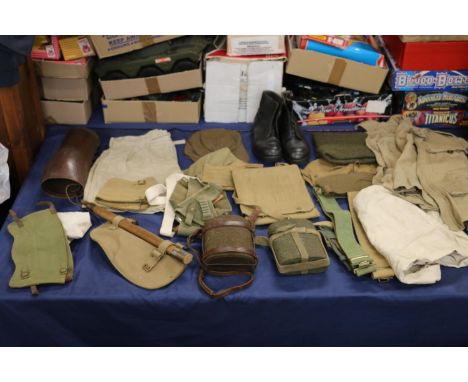
WWII silk escape map, double-sided including Romania, Northern Italy, Serbia, Bulgaria, Hungary, Croatia etc., also a case containing a British Red Cross nurses diaries and badges including Red Cross Monmouth shoulder titles, enamel badges WVS Civil Defence badge, George VI Services Rendered badge [341913], etc.

Lot 332
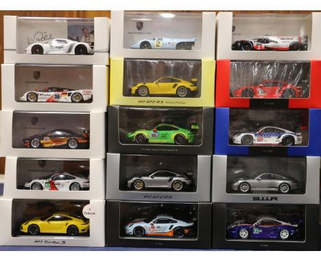
Fourteen 1:43 scale collectors model vehicles including Pauls Model Art Minichamps WAP 020 047 97 Porsche 993 GT 1 1996 and WAP 020 046 97 Porsche 956 C Coupe 1982. Spark (Minimax Import & Export Co Ltd) MAP 020 874 15 Le Mans 2015 Porsche 919 Hybrid. HPI Racing 8175 toyota Celica Turbo 4WD #3 1995 Safari. Auto World AWRSS1151 The Dukes of Hazrd General Lee 1969 Dodge Charger. IXO Models RAM087 Ford Focus RS 02 Winner Safari 2002. Model Icons 999509 Mitsubishi Lancer Evolution X Essecx Police ANPR Intercept Unit. Aston Martin Racing Collection A07MC1-43 Aston Martin Vantage GTE. etc., each boxed. (14)
Lot 122
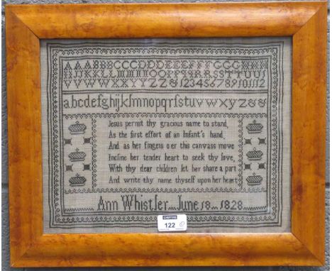
A needlework sampler dated 1828 by Ann Whistler, 25 x 32cm, maple framed, and a pen and ink map of Suffolk by 'Master J Vince', 46 x 58cm including maple frame (2)Map, quite browned, multiple creases to the left hand side, some minor light spots throughoutNeedlework: condition is goodSee images


Lot 212
Three boxed Beswick Beatrix Potter figures: Pigling Bland, And This Pig Had None and Benjamin Ate A Lettuce Leaf (all undamaged), a Polaroid 600 Extreme instant camera (working order but hand strap broken), hallmarked silver child's rattle with mother of pearl handle, a Florenza yellow metal coloured necklace, hardback copy of Longfellow's Poetical Works (1912), an American silver plated Paul Revere bowl, plated salt shaker and teapot etc. Also included a wall hanging cloth map of Lancashire and Yorkshire 122 x 92cm and a limited edition photographic print "Gateway To The Moors II", 5/50 by Joe Cornish 54.7 x 66.7cm (qty)


Lot 1414
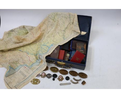
Army Air Forces Training Command diploma certificate dated 20th December 1944, an Army Service Forces Transportation Corps embarkation slip (USS Hermitage 22 November 1945) and a World War II map, sheet 72 France and Belgium 64.5cm x 48cm. Also included a US presidential memorial certificate for a Carlisle M Brown with gold embossed header (printed LBJ signature) and Veterans Administration letter from Omar Bradley (printed signature). (5)


Lot 125
A Map of Middlesex by John Speed and John Norden, 'Midle-Sex described with the most Famous Cities of London and Westminster', Thomas Bassett and Richard Chiswell, a hand-coloured engraved map with inset views of Westminster, London, Saint Peters and Saint Pauls, 40.5 cm x 52.5 cm, within a glazed frame (glass a/f)

Lot 152
A pair of J R R Tolkien books, to include: - The Hobbit (1957) 9th Impression: George Allen and Unwin. Wear and tears to dust jacket along edges and spine. - The Silmarillion (1977) 1st Edition 4th Impression: Cambridge University Press. Sun damage to spine of dust jacket and clipped inside. Pictorial map to end cover in-tact


Lot 140
Various wooden items and collectibles to include two silver-topped cut glass jars, length of longest 17.5cm, a fold-out map titled 'Reduced Survey Map of Windermere and Morecambe Bay', a Habana wooden cigar box (af), an oak four-section desktop stationery box, an inlaid wooden knee writing desk (af), and a wooden cased set of fish knives and forks (7).Condition Report: - The cigar box has damage to the side.
Lot 1084
TWO ITEMS - AN 1885 ORDNANCE SURVEY MAP OF CHESHIRE / DERBYSHIRE PLUS AN 1872 ORDNANCE SURVEY MAP OF NORTHENDERN, CHEADLE, WIMSLOW AND STOCKPORT PARISH, CHESHIRE ( EASTERN DIVISON ) PLUS AN 1884 MAP OF WARWICKSHIRE, AF & A PLAN OF LAND SITUATE IN ARDWICK BEING THE PROPERTY OF W & J BROCKLEHURST ESQRS SURVEYED BY W MELLOR - APPROX 120 X 95 CM

Lot 1184
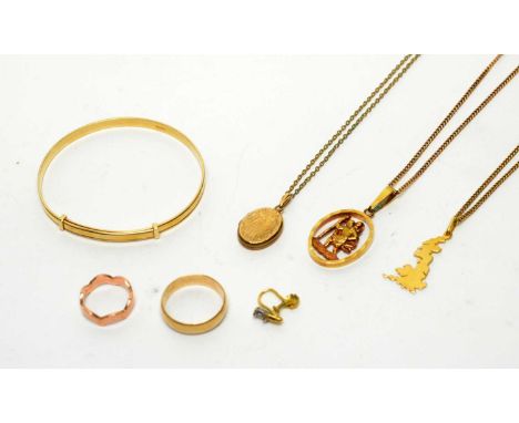
A collection of gold and other jewellery, including: 9ct gold bangle; 9ct gold St Christopher pendant, on 9ct gold chain; 9ct gold locket pendant; 9ct yellow gold wedding band, size P 1/2; 9ct rose gold ring, size G 1/2; 18ct gold United Kingdom map pendant; and other jewellery, 31.g gross.

Lot 576
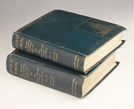
Nansen (Fridtjof), FARTHEST NORTH, BEING THE RECORD OF A VOYAGE OF EXPLORATION OF THE SHIP FRAM 1893-96 AND OF A FIFTEEN MONTHS' SLEIGH JOURNEY BY DR. NANSEN [...], 2 vols, first edition, green cloth boards, gilt embossed illustrations to covers, colour and monochrome plates and illustrations throughout, foldout map of The Route Of The Fram to vol 1 (General Map Of The Polar Regions not present), foldout map of The Kaiser Franz Josef Land to vol 2, Archibald Constable And Company, Westminster 1897 (2) (at fault)

Lot 585
Mogg (Edward), PATTERSON'S ROADS; BEING AN ENTIRELY ORIGINAL AND ACCURATE DESCRIPTION OF ALL THE DIRECT AND PRINCIPAL CROSS ROADS IN ENGLAND AND WALES WITH PART OF THE ROADS OF SCOTLAND, later full leather, fold-out 'General Map' frontispiece, fold-out 'Holyhead Road' plate, printed for Longman, Hurst et al, London 1822, with THE GENERAL TURNPIKE ROAD ACT, 3 GEO. IV. CAP. 126, second edition, blue card boards, London 1826, and The Highway Act, full leather, lacking title page, London 1773 (3) (at fault)
Lot 602
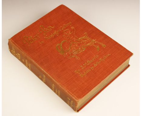
Barrie (J.M.), PETER PAN IN KENSIGNTON GARDENS, first thus, illustrated by Arthur Rackham, brown cloth boards, gilt embossed illustrated cover, map to front free endpaper, half title, tipped in tissue guarded frontispiece, illustrated title page, fifty tipped in tissue guarded plates bound in at the rear, Hodder & Stoughton, London 1906 (at fault) CONDITION REPORT:Expected shelf wear to lower edges and boards (particularly lower front corners). Bumps to all corners. 1cm partial split to upper edge of spine. 12mm split to lower edge of spine. Wear to spine edges. Age related darkening to pages (particularly towards page edges). Some finger marks to pages. Pencil inscription next to first line of chapter 1.
![[WWII / MILITARY] WWII silk escape map, Europe, double-sided; & a small q. of ephemera (Q).](https://cdn.globalauctionplatform.com/0e6331eb-2dce-4315-8855-b045010808cb/3608cbe4-dfd8-4a6a-a930-b045010e95b9/468x382.jpg)
![[FRANCE: BRITTANY, NORMANDY, etc.] TURNER (Dawson & Mary) & COTMAN (John Sell, illustrator:) Account of a Tour in Nor](https://cdn.globalauctionplatform.com/0e6331eb-2dce-4315-8855-b045010808cb/88663fea-0520-4714-8e4f-b045010ebdd1/468x382.jpg)
Lot 156
[FRANCE: BRITTANY, NORMANDY, etc.] TURNER (Dawson & Mary) & COTMAN (John Sell, illustrator:) Account of a Tour in Normandy; undertaken chiefly for the Purpose of Investigating the Architectural Antiquities ..., 2 vols, 8vo, 50 etched plates by Mary Turner, many after drawings by John Sell Cotman, 19 text illustrations; later green binder's pebble-grained cloth (some damp-staining to the covers, small portion torn from the margin of G6 in Vol. I. ), L.,1820; JACKSON (Mary Catherine) Word-Sketches of the Sweet South, 8vo, frontis., cloth, 1st Edn., L.,1873; JEPHSON (J.) Narrative of a Walking Tour in Brittany, Accompanied By Notes of a Photographic Expedition by Lovell Reeve, 8vo, mounted stereoscopic photographic view as frontispiece, pp. xvi, notice leaf tipped in, folding map with hand-colouring, 1st Edn.,L., 1859; TROLLOPE (T.) & TROLLOPE (Frances) A Summer in Brittany, 2 vols, 8vo, 2 hand-coloured costume frontispieces, 10 plates, engr. pictorial titles, original cloth, L.,1840; & 5 other vols (9).
![[MAPS] SAXTON & KIP "Bedford. Comitatus olim pars Cathifuclanorum", h-col'd engr. map, unframed, 12.5 x 15 inches [5], ce](https://cdn.globalauctionplatform.com/0e6331eb-2dce-4315-8855-b045010808cb/0f7f1e24-9b6e-4c78-8bd1-b045010eca4d/468x382.jpg)
![[IRELAND] a collection of DUBLIN imprint ALMANACKS, as follows: 1778, Watson; 1788 Watson + Exshaw + Wilson; 1791Watson + Exs](https://cdn.globalauctionplatform.com/0e6331eb-2dce-4315-8855-b045010808cb/03ca33ae-faaa-4377-9b86-b045010ecc6b/468x382.jpg)
Lot 173
[IRELAND] a collection of DUBLIN imprint ALMANACKS, as follows: 1778, Watson; 1788 Watson + Exshaw + Wilson; 1791Watson + Exshaw; 1805 Triple Almanack; 1806 Double Almanack; 1808 Stewart Almanack; 1809 Stewart + Engl. Registry + Wilson's with map at back; 1810 Treble with map at back; 1811 Stewart only; 1812 Treble (slight loss to pp. 195/6; rebacked) map at back; 1813 Stewart + Engl. Registry only, poor copy; 1814 Treble with map at back; 1815 Stewart + Wilson, no map; 1816 Treble with map at back (lacks frontis., rebacked); 1818 Treble with map at back; 1819 Treble with map at back (rebacked); 1823 Treble with map at back; 1824 Treble with map at back; 1825 Treble lacking frontis and map; 1826 Treble with map at back (small piece excised from title with loss); 1827 Treble with map at back; 1828 Treble with map at back; 1829 Treble with map at back (small piece excised from one of the titles with loss); 1832 Treble, lacks frontis & map, back cover off; 1833 Treble with map; 1836 & 1837 with facsimile maps?; 1839 defects, no map; 1840, 1841, 1842 Watson + Engl. Registry + P.O. Directory, 2 folding maps at back; 1843 & 1844 with 1 map only (not the P.O. one); in all, 33 volumes, variously bound (some expert repairs), a few red morocco with royal arms; sold as a collection not subject to return (33).
![[MAPS] Survey of Pakistan / Bangladesh DACCA GUIDE MAP, 34 x 26 ins., text etc. verso, wooden rollers "Corrected up to 1968",](https://cdn.globalauctionplatform.com/0e6331eb-2dce-4315-8855-b045010808cb/c66299eb-cafd-4526-97f9-b045010ed375/468x382.jpg)
![[ALGERIA] MORRELL (J. R.) Algeria...' 8vo, plates & illus., folding map loose within, morocco gilt (rebacked) with origin](https://cdn.globalauctionplatform.com/0e6331eb-2dce-4315-8855-b045010808cb/814f570f-4480-4c32-b702-b045010ee765/468x382.jpg)

Lot 254
TOLKIEN (J.R.R.) The Silmarillion, George Allen & Unwin, d.w., 1977, 1st edition, together with a Alan Lee illustrated copy of The Lord of the Rings, a Ted Marsh illustrated copy of the Silmarillion, a brass figure of Gandalf, a pewter goblet and a framed faux antique map of Middle Earth, f. & g., 27 x 34 inches. (Q).
![[CHINA] 9 plates only, incl. d.p. map, from Staunton's China, large folio, 1796.](https://cdn.globalauctionplatform.com/0e6331eb-2dce-4315-8855-b045010808cb/b8badc2e-bb17-4960-8d29-b045010f4299/468x382.jpg)
![[MAP] SPEEDE (John) Herefordshire, double-page, text verso, early colouring, unframed, 16 x 20.4 inches.](https://cdn.globalauctionplatform.com/0e6331eb-2dce-4315-8855-b045010808cb/98e4cadb-e33b-4198-b332-b045010ffcbf/468x382.jpg)
![[MILITARY MAPS] O. S. "Aldershot Command", 40 x 32 inches, folding, linen-backed, War Office, 1934; O. S. "Ten Mile Map" stam](https://cdn.globalauctionplatform.com/0e6331eb-2dce-4315-8855-b045010808cb/c6177bcf-56dd-4823-a867-b04501100623/468x382.jpg)
Lot 996
After James Malton (1761-1803) "A Picturesque and Descriptive View of the City of Dublin, displayed in a series of the most interesting Scenes taken in the Year 1791, with a brief authentic history from Earliest Accounts to the Present Time," 24 hand coloured engraved Plates (framed) each approx. 32cms x 42cms (12 1/2" x 16 1/2") in matching hogarth type frames; together with the printed text with engraved t.p., dedit., hand coloured Arms of the City of Dublin, fold. map of the City of Dublin, engd. Survey Plate, each text page with engd. vignettes, marble endpaper, full mor. with tooled gilt panels and borders, decor. panelled spine. Rare complete set, in good condition. (25)


Lot 308
A collection of English and other coinage, tokens, pocket watches and earrings, to include William III sixpence (date rubbed); George II halfpenny (1746); George III farthing (1806); halfpennies (1773, 1806 and date rubbed); George IIII shilling (1822); William IIII farthing and halfpenny (both 1837); Victoria and later shillings, sixpences, threepences; Louis XVI 2 sols; A Map of France 1794 token; Anglesey Parys Mines Co penny token; Exeter halfpenny 1792; Pidcock's Exhibition token; other coins, tokens and banknotes; five modern pocket watches of various designs; pair of 9 carat yellow gold knot design earrings; and other yellow metal and white metal earrings.Condition report:This lot contains the following British silver content coins:Shillings - 1822, 1874, 1924, 1927 (x3), 1929, 1930, 1944Sixpences - William III (rubbed), 1900, 1916, 1918, 1924, 1934, 1938Fourpences - 1836 (drilled), 1845, 2 rubbedThreepence - 1843 (rubbed)Twopence - 1838 (drilled)Australia shilling - 1942India - 1/4 rupee (1917)South Africa - shilling (1932) and sixpence (1941)


Lot 426
Selection of prints including two Snaffles style character prints titled 'The Sportsman' and 'The Spooney', Spy print of 'The Master of The Heythrop' (Mr Albert Brassey), Vale Royal, two small framed prints Mark Lane 'The Corn Exchange' and The Custom House, framed Thornton's New & Complete Survey of London & Westminster and a Map of The Various Meets of The Belvoir Hounds

Lot 434
Hand-coloured reproduction of "Prospect of a Noble Terras Walk" City of York, The Royal Sussex Regiment map of Sussex produced for the Women's Land Army Benevolent Fund by Donald McCullough April 1945, after John Speed map of "The North East Ridins of Yorkshire", after Robert Morden map of Lincolnshire & framed Tailor & Cutter Academy London diploma dated 1907

Lot 159
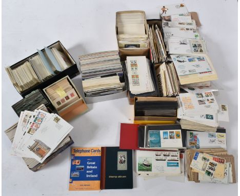
A large collection of foreign and British definitive and commemorative postage stamps, airmail, covers and first day covers, majority being 20th century but with some mid - late 19th century. Air mail covers to include Australia, Zambia, Uganda etc. FDCs, mostly 1990s, to include Football Legends 96, 100 Years of going to the Pictures 1996, D Day 1994, Swans 1993, Map 1991, etc. Lot to include a handful of Victorian stamps, including one cancelled penny red. A large collection, in various boxes.

Lot 88
PAPUA NEW GUINEA. Gold 100 kina, 1980 FM. Franklin Mint, United States. Proof. Coat of Arms of Papua New Guinea: a bird-of-paradise over a traditional spear and a kundu drum. "PAPUA NEW GUINEA 900/1000 FINE GOLD FM 1980". / Map and flag above value. "5th ANNIVERSARY OF INDEPENDENCE K100". Edge Milled.In secure plastic holder, graded NGC PF 69 ULTRA CAMEO, certification number 1907372-015. NGC Census in this grade: 11.NGC Census in higher grade: 4Total NGC Census: 17Reference: KM-14Mintage: 1,118.Weight: 9.57 g. (AGW=0.2769 oz.)Composition: 900.0/1000 Gold.PLEASE NOTE: 6% Buyer Premium + VAT on this lot. Additional 6% fee charged on the Saleroom. Delivery cost will be added to your order.This lot is exempt from VAT. Payment can be made in EUR, CHF, or USD for an exchange fee. Please contact us to find out more.

Lot 148
(Local Interest) Twenty Prints and Paintings to Include: Elizabeth Street - Woodland Stream, oil on board, 28 x 23 cm; Pair of glass paintings of scenes in nature, oil on glass, 29 x 44 cm; Pair of botanical studies, oil on board, monogram lower left, 27 x 60 cm; J. Wright - 'The Rev. George Heath', engraving published 1890, 25 x 34 cm in antique gilt frame; Map of Cirencester, 11 x 17 cm; A Chromolithograph and two coloured engravings of landscapes; The 19th century lithographs 'The Watering Place' and one other after W. F. Wells; together with five studio watercolour sketches and four printed photographs of trains and others (20)
-
109182 item(s)/page