We found 109198 price guide item(s) matching your search

Refine your search

Year

Filter by Price Range
  • List
  • Grid
  • 109198 item(s)
    /page

Lot 22

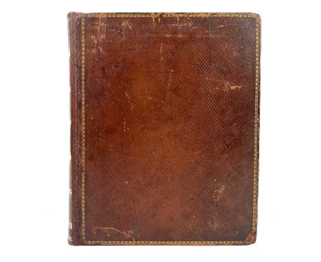
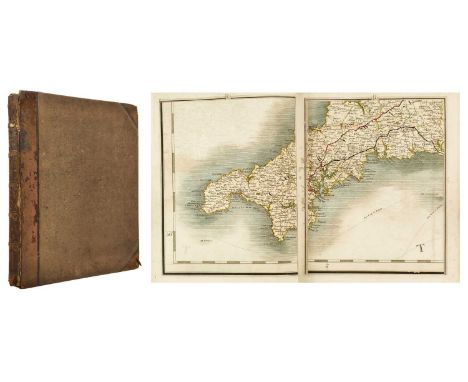
BORLASE, William. 'Observations on the Antiquities Historical and Monumental, of the County of Cornwall,' First edition, rebacked with original full calf by Chivers of Bath, red morocco label and ornate gilt embossing to spine, ex libris label to pastedown for Newport Reference Library, ink stamp to title page, presentation label to verso of titlepage 'to the library from E. A. Lee of the Coldra', dedication, i-xvi, pp.413, errata, 31 plates inc. 24 full page and map present, sporadic libris stamp to margins throughout, some toning and finger soiling to a generally good to very good copy, W. Jackson, Oxford, 1754.

Lot 221

JOHANNES BLAEU and TIMOTHY PONT 'Leogus et Haraia insulae ex Aebudarum numero quae quamquam isthmo cohaereant pro diversis habentur,' 'Lewis and Harray of the numbre of the Westerne Yles which two although they joyne be a necke of land ar accounted dyvers ylands,' hand coloured engraved map of The Isles of Harris and Lewis in the Outer Hebrides, some light spotting, middle fold, Spanish text to verso, mounted in card Amsterdam, circa 1654, 41.5cm x 54.5cm; Together with a late 18th-century map of the same Isles, 20cm x 32cm. (2)

Lot 223

CELLARIUS, Andreas (ca. 1596-1665) 'Harmonia Macrocosmica seu Atlas Universalis et novus, totius Universi Creati Cosmographiam generalem et noviam exhibens,' A hand tinted copper engraved celestial map, decorated in the baroque style, centre fold, some spotting, a rare survivor of an important work, large folio, mounted, framed and glazed, Amstelodami, Joannem Janssonium, c.1661. (44cm x 50cm).A plate from what is considered the most beautiful celestial atlas ever published (and one of the masterpieces of the golden age of celestial cartography). The Atlas Coelestis seu Harmonia macrocosmica, by the famous German cartographer, mathematician and cosmographer Andreas Cellarius, brings together old and new knowledge on the subject, showing the planetary systems according to the theories of Ptolemy (geocentrism), Copernicus (heliocentrism) and Tycho Brahe (geoheliocentrism). A very decorative and scarce framed leaf.

Lot 224

CELLARIUS, Andreas (ca. 1596-1665) 'Harmonia Macrocosmica seu Atlas Universalis et novus, totius Universi Creati Cosmographiam generalem et noviam exhibens,' A hand tinted copper engraved celestial map, decorated in the baroque style, centre fold, some spotting, large folio, a rare survivor of an important work, mounted, framed and glazed, Amstelodami, Joannem Janssonium, c.1661. (44cm x 50cm)A framed leaf from what is considered the most beautiful celestial atlas ever published and one of the masterpieces of the golden age of celestial cartography. The Atlas Coelestis seu Harmonia macrocosmica by the famous German cartographer, mathematician and cosmographer Andreas Cellarius brings together old and new knowledge on the subject, showing the planetary systems according to the theories of Ptolemy (geocentrism), Copernicus (heliocentrism) and Tycho Brahe (geoheliocentrism). This chart is noted as it is centered on a map of the world on a North Polar projection showing the Island of California.

Lot 225

CELLARIUS, Andreas (ca. 1596-1665) 'Harmonia Macrocosmica seu Atlas Universalis et novus, totius Universi Creati Cosmographiam generalem et noviam exhibens,' 'Braheum Structura Ex Hypothesi Brahei in Delineata,' a hand tinted copper engraved celestial map, decorated in the baroque style, centre fold, some spotting, large folio, a rare survivor of an important work, mounted, framed and glazed, Amstelodami, Joannem Janssonium, c.1661. (44cm x 50cm)A plate from what is considered the most beautiful celestial atlas ever published (and one of the masterpieces of the golden age of celestial cartography). The Atlas Coelestis seu Harmonia macrocosmica, by the famous German cartographer, mathematician and cosmographer Andreas Cellarius, brings together old and new knowledge on the subject, showing the planetary systems according to the theories of Ptolemy (geocentrism), Copernicus (heliocentrism) and Tycho Brahe (geoheliocentrism). A very decorative and scarce framed leaf.

Lot 235A

SPEED, John. Cornwall A hand coloured engraved map from Speed's 'The Theatre of the Empire of Great Britain', with inset view of Launceston, large strapwork cartouche and compass rose, Latin text to the verso titled 'Cornwallia sive Cornubia', framed and glazed, 41cm x 53cm, John Sudbury and George Humble, London, 1616.As this map lacks Irish or Virgivian Sea below the cartouche of Launceston and the fact there is Latin text to the rear, it indicates that this plate was published pre 1623 and was therefore published in 1616 (Quixley and Quixley. 'Antique Maps of Cornwall and the Isles of Scilly,' p.35). A vibrant example in vg condition. Very good overall condition, no rips or tears, colours are strong throughout. Sporadically, there are small incidences of singular spots. Although only seen close up and generally to the margins. I would suggest this map would want reframing, as the paper is slightly crumpled, with some fold marks visible. Coincidentally, whilst examining the map, it appears this was previously sold from 'The Old Master Galleries' in Oxford Street, London. This map has not been examined out of its frame.

Lot 236

Penzance Interest A substantial map of Penzance, annotated for the redesign of the harbour and docks , 1877 Penzance Harbour and Docks, Contract No.1, Drawing No.1, paper backed onto linen, surveyed in 1877 by Lieut H. R. G. Georges, Levelled by Capt W. Wynne, Ordnance Survey Office, Southampton, 120cm x 198cm.A unique map, used as a working document to establish the harbour from the dry dock that it was initially to the harbour layout, which we largely see today. With handwritten annotations indicating areas to be paved in granite (violet), macadamized (burnt sienna), merely filled up (pink), the areas of the harbour to be deepened (green) and the site of the new graving dock (yellow). Signed by John Matthews Jnr (responsible for the design of a number of lighthouses including Pendeen Watch and Beachy Head), the (then) mayor of Penzance, Charles Campbell Ross (1849-1920 whose familial home is now Morrab Gardens and Morrab Library) and other surveyors and engineers involved with the redesign of the harbour and docks. Though the map has suffered some loss and damage, it does not detract from the historical importance of the piece. Together with two maps from the same period of Pezance Harbour and surroundings without annotations and a print onto card of Penzance depicting the area before the harbour was modernised and before the building of the lido.

Lot 237A

Six Maps including examples by Robert Morden and Christopher Saxton Christopher Saxton; a 17th Century hand-coloured map of Huntingdon and another 17th century example of Brechnock-shire; Christopher Saxton & William Kip, Northamptoniae Comitatus Descriptio... Northamptonshire, hand-coloured county map, 28.5x36cm and a 17th Century Saxton Kip hand-coloured engraved map pf Rvtlandie (Rutland); Saxton - Kipp, hand-coloured engraved map of Dunelmensis, map of Durham, with some loss and tears; and Robert Morden (c.1650-1703) map of Shropshire with hand-tinted engravings, from Thomas Camden Britannica, published 1695-1722.

Lot 243

Cornish ephemera. J. & C. Walker. 'Cornwall,' a steel engraved map, backed onto linen, folded, colour borders, Longman, Orne, Rees & Co, London, 1843; 'The measurement in statute Acres. of the Parishes in Cornwall and Population in 1800 and 1811,' nine leaves of handwritten tables on folded string bound leaves, [c.1811]; John T. Barber. 'Poems of Old St. Ives,' printed thin card wraps, staple bound, W & J Jacobs, St Ives, [1956]; 'The St. Austell Recipe Book,' original printed boards, an amateur repair with wraps wrong way round, vg text block, J. Warne and son, Globe Offices, St. Austell, n.d; 'The Visitor's Guide to the Literature of Cornwall, Being a Catalogue,' by Joseph Pollard, staple bound, pp,23, Truro and Penzance, n.d; Thomas Taylor. 'Ruan Minor and Grade,' printed tin card wraps with vignette engraving of the church of St. Ruan Minor, staple bound, some spotting, one plate, pp.8, the Cornish Echo, Falmouth, 1929; With a lease of a house and land, The Rev'd John Rodgers to Mr Peter Thomas, Ludgvan, 25th July, 1854; With another indenture from Cornwall. (8)

Lot 247

The Isles of Scilly. Early tour guides and other works. J. S. Courtney. 'A Guide to Penzance and its Neighbourhood, Including the Islands of Scilly,' rebacked with original marbled boards, frontis lithograph, fold out map and seven illustrations as called for, some sporadic spotting but generally good to very good, pp.223 with a further pp.91 for the appendix, errata, E. Rowe, Penzance, 1845; Leonard H. Courtney. 'A Week in the Isles of Scilly,' revised edition, original publishers blind wraps, some light spotting, pp.121, 6 pages of advertisements to rear, E. Rowe, Penzance, 1867;J. C. and R. W. Tonkin. 'Guide to the Isles of Scilly,' second edition, original embossed cloth, rubbed and bumped, contemporary ink inscription to titlepage, tear to vg fold out map, frontis, pp.110, advertisements to rear, F. Roddaa, Penzance, 1887; With a third edition, with repaired card wraps, 1893; James G. Owen. 'Faire Lyonesse. A Guide to the Isles of Scilly,' original printed card wraps, tape repair to spine, staple bound with rear detaching, illustrated and advertisements throughout, pp.97, Coles & Owen, Bideford, 1897; With nine other works on the Isle's of Scilly including by Jessie Mothersole, Walter Besant and Ruth Tamar Carruth. (15)

Lot 256

AIKIN, J. 'A Description of the Country from thirty to forty Miles around Manchester,' Half leather with marbled boards, heavily rubbed in places, engraved frontispiece and additional title, two large folded engraved maps, one being of Manchester and Salford, closed tears repaired; the other in colour 'The New Map of The Country Round Manchester, 1794; occasional light spotting to leaves, John Stockdale, London, 1795.The back strip is splitting along the rear joint with chips and nibbles to the ends. Loss to leather to bottom right corner of rear board, generally rubbed and bumped all over. Ink owner signature to front free endpaper, spotting to frontis and engraved title page, finger soiling to printed title page, a-2 i-xi, list of plates, list of subscribers, pp.1-624, 73 plates as called for, the two thick paper fold out maps to the rear have tape repairs to verso, and due to the weight have died from the text block with pp.623 of the index.Sporadic spotting throughout, generally found near the plates.

Lot 26

KALM, Pieter. 'Reis Door Noord Amerika, geddan door den Heer Pieter Kalm, Professor in de Huishoudingskonst op de Hoge School to Aobo, en Medelid der Kolninglyke Zweedsche Maatschappy der Wetenschappen,' First Dutch edition, a deficient copy missing fold out plate four, map and extra titlepage (needless to say its binding!), nibbles and toning to edges of leaves but in a surprisingly good condition considering, pagination runs true, J. van Schoonhoven en Comp en G. van den Brink Janz, Utrecht, 1772.This Dutch edition was published in the same year as the first Swedish, which Lande calls "far superior to the [original] Swedish and English editions."

Lot 310

SMITH, William. 'A New & Compendious, History of the County of Warwick,' Modern half polished calf with marbled boards, compartmentalized spine with morocco labels and gilt tooled decorations, map and sixty plates with staining as expected, engraved title page, a very good copy, W. Evans, Birmingham, 1830.

Lot 361

Edmund H. Sedding Norman Architecture in Cornwall 1909. 'A Handbook to Old Cornish Ecclesesiastical Architecture, With Notes on Ancient Manor Houses with a Chapter on the Old Saints of Cornwall,' first edition, hard cover, 464 pages, white cloth spine with gilt lettering and architectural decoration to green boards, 162 b&w plates, fold out map of Cornwall to rear with one unrepaired tear, pages uncut, subscribers list showing 123 copies, large paper copy, fine condition, Ward & Co, Charing Cross, London, 1909.

Lot 372

FOLIO SOCIETY 'The Chronicles of Narnia,' by C.S. Lewis. Seven volumes in illustrative gilt slipcase displaying a map of Narnia, vg, The Folio Society, London, 2000.

Lot 402

(Ichthyology) KURONUMA, Katsuzo and ABE, Yoshitaka. 'Fishes of Kuwait,' Green cloth covers with black lettering to spine and front, unclipped photographic dj, map print to endpapers, card slip, pp.123, 20 colour plates at back and line drawings in text, vg to fine, Kuwait Institute for Scientific Research, 1972.A marine biological survey of vertebrate animals in the Kuwait coastal waters and the Arabian Gulf was conducted in 1969, This book is the report of that survey.

Lot 492

BORLASE, William. 'Antiquities, Historical and Monumental, of the County of Cornwall,' 'Consisting of Several Essays on the First Inhabitants, Druid Superstition, Customs and Remains of the Most Remote Antiquity in Britain and the British Isles, Exemplified and Proved by Monuments Now Extant in Cornwall and the Scilly Islands, with a Vocabulary of the Cornu-British Language,' the second edition revised, original full leather rebacked, gilt titles to spine, book sellers label to pastedown Thornton & Son Oxford, fold out frontis map, i-xvi, pp.464, plates and illustrations complete, some offsetting but generally a very good to fine text block, marble edge, W. Bowyer and J. Nichols, London, 1769.Formerly in the library of Cornish historian Charles Thomas (1928-2016).

Lot 494

BORLASE, William. 'Observations of The Antiquities, Historical and Monumental of the County of Cornwall,' First edition, original burr full leather tastefully rebacked, contemporary ink signature to head of title page, some small tide marks and soiling to margins throughout, 31 plates inc. 24 full page and map present, pp.413, a very good copy, W. Jackson, Oxford, 1754.Formerly in the library of Cornish historian Charles Thomas (1928-2016).

Lot 497

POLWHELE, Richard. 'The History of Cornwall,' Vols I, II, III bound in one, rebacked diced full calf, morocco labels, lacks title page to vol II, map and two plates, with seventeen plates altogether, some light spotting and toning, marbled edge, T. Flidell, Falmouth, Cadell and Davies, London, 1803.Formerly in the library of Cornish historian Charles Thomas (1928-2016).

Lot 521

BLIGHT, J. T. 'A Week at the Land's End First edition, original embossed cloth, frontis and engraved vignette to title page, fold out map, some light toning to edges of leaves, pp.233, advertisements to rear, vg, Longman, Green, Longman, and Roberts, London, 1861; C. E. Vulliamy. 'Unknown Cornwall,' illustrations by Charles Simpson, first edition, original cloth, plates and illustrations throughout, vg, John Lane The Bodley Head, London, 1925; With a copy of 'A Walk from London to Land's End and Back' by Elihu Burritt, 1868. (3)Formerly in the library of Cornish historian Charles Thomas (1928-2016).

Lot 539

RAYMOND, George Frederick. 'A New, Universal and Impartial History of England, From the Earliest Authentic Records, and Most Genuine Historical Evidence, To the Year 1784,' Modern full polished calf, compartmentalized spine with morocco label and gilt lettering, conservation to title page and engraved frontis, fold out map by Thomas Bowen rebacked onto thin card, numerous full plates, pp.608, list of subscribers to rear, J. Cooke, at Shakespear's Head, London, [c.1785].

Lot 54

Ancient Crosses, and Other Antiquities in the East of Cornwall J. T. Blight William Cornish, Penzance; second edition; loose title-page and three other pages, fragile; heavy-toning throughout; 1872; together with Arthur G Langdon, Old Cornish Crosses; Truro; Pollard; 1896. First edition, first printing. Very good in blue boards with fold-out frontispiece map.

Lot 61

Six works about Cornwall. Richard Stephen Charnoch. 'Patronymica Cornu-Britannica; or, the Etymology of Cornish Surnames,' first edition, original cloth with bevelled edges, small amount of spotting, a very good copy in original binding, Longmans, Green, Reader and Dyer, London, 1870; 'The Cornish Church Guide,' original publishers boards, plates, foldout map, advertisements, vg, Oscr Blackford, Truro, 1925; 'Cornish Recipes Ancient and Modern,' issued by the Cornwall Federation of Women's Institutes, eleventh edition, thin card wraps, pp.73, A. W. Jordan. Truro, 1934; With two guides to 'Fowey' and 'The Isles of Scilly' in vg condition; and one other. (6)

Lot 646

St Austell and Fowey interest. Four early guides, 1920’s. A. L. Rowse. 'St Austell Church, Town, Parish,' first edition, hardcover, very good condition with dustwrapper (slight tear), subscribers edition (larger format than the standard edition), limited to 719 copies this one being 123, 94 pages, 35 photographs and illustyrations, including a map of st austell, signed by A. L. Rowse, tipped in 12 newspaper cuttings, 4 invoices from local suppliers dated 1890/1891, a ‘’Walk-Round-The Church’’guide circa 1965, with a list of arrangements for the ‘Festival of Flowers Holy Trinity, St Austell 25th-27th June 1965, pub by H. E. Warne Ltd, St Austell, 1960.Four early Fowey guides bound in 1 volume: 'Fifty Years Vicar of Fowey a Memento of Trinity Sunday 1917,' pub by A. R. Mowbray & Co Ltd, London; H. S. Graham. 'Fowey Official Guide,' pub by William Brendon and Son Ltd, Plymouth, 33 pages plus copious local advertisements, circa 1920’s; 'Fowey South ‘The Official Guide’, circa 1930’s, pub by the Home Publishing co, Croydon, introduction by Arthur Quiller-Couch, 39 pages plus many pages of local advertisements; 'Fowey Official Guide,' pub by Vickery, Kyrle & Co Ltd, London, circa 1910; With the booklate of John Blowey.Harold Warren. 'The History of St Austell Market House,' circa 1980’s, 32 pages. (3)

Lot 660

(Ephemera and booklets) Eleven diverse works. Barak Longmate. 'Stockdale's Peerage of England, Scotland and Ireland,' vol I, toning and loss to original printed wrap, numerous plates, John Stockdale, London, 1811; 'Collins Standard Map of London,' engraved map backed onto linen, loss to original covers, folded, early 20th century; Paul Peter Piech. 'War and Misety,' limited edition, 76/125, twelve (as called for) individual woodcuts, housed in original folded slip, The Taurus Press, Kenton, n.d; Original headed letter paper from 'Arabesque' with the names Gregory Peck, Sophia Loren and Stanly Donen in red ink; With six other pieces including an original programme for 'Tilda's New Hat' by George Paston, 1909. (9)

Lot 67

CARY, John (engraver). 'Cary's New Map of England and Wales, with Part of Scotland. on which are carefully laid down, All the Direct and Principal Cross Roads, the Course of the Rivers and Navigable Canals,' Half leather, rubbed and bumped with splitting to joints, engraved title and hand-coloured general map, 80 of 81 maps with map 62 missing as is the norm, ex libris of J. J. Pitcairn (R. Austin Freeman and Clifford Ashdown) with owner stamp to the head margin of titlepage and front endpapers, later newspaper articles pasted to front pastedown and front free endpaper, index to rear pp.85, three pages of subscribers, some toning, light spotting to margins but otherwise a vg textblock, J. Cary, London, 1794.Cary's map incorporated the latest cartographic techniques of the period, including precise surveying and engraving methods. It set a standard for mapmaking that influenced future cartographers and contributed to the development of modern cartography. This is a good example of this aesthetically pleasing atlas, with a rather interesting former owner.

Lot 986

Mickleburgh (The Rev. James), Maps of the Society for Diffusion of Useful Knowledge with an Index of the Principal Places in the World, fo., halfcalf and marble boards, (front cover detached), illus. with 160 hand-coloured engraved maps including world hemispheres, a geological map of England and Wales, and 17 depicting North America, together with 51 plans of cities throughout the world; published by the Society and Chapman & Hall, London 1844.

Lot 987

A large linen-backed, hand-coloured map of Sutherland and the Northwest part of Scotland, of scale three-quarters of an inch to one mile, in slip-case; retailed by Mawson, Swan and Morgan, Newcastle-Upon-Tyne.

Lot 995

Drake (Francis), Eboracum: The History and Antiquities of the City of York, fo., full calf, illus. with mezzotint frontispiece, engravings, and fold-out map, 1736; bearing the bookplate of Serjeantson of Hanlith.

Lot 1614

After Thomas Dugdale (fl. 1838 - 1843) A map of Cumberland, watercolour tinted engraving, engraved by Joshua Archer, leaf from Thomas Dugdale, "Curiosities of Great Britain", John Tallis, London, circa 1850, in card mount and moulded frame under glass, 31 cm x 38.5 cm overall

Lot 1624

After John Cary (circa 1754 - 1835) A watercolour tinted map of Cumberland, engraving, dated 1793, in card mount and parcel gilt frame under glass, 34.5 cm x 39.5 cm overall

Lot 305

A 1944 dated British army webbing map case together with a tropical jungle green canvas map case

Lot 321

Second World War Pattern 1937 webbing, a water bottle, entrenching tool, map case and other webbing

Lot 494

Edward Baines, "A Companion to the Lakes of Cumberland, Westmoreland; and Lancashire; in a descriptive account of a family tour, and excursions on horseback and on foot. With a new, copious, and correct itinerary", London, Simpkin and Marshall, 1834, containing a watercolour tinted, cloth-backed map of The Lake District, Cumberland, Westmoreland and Lancashire affixed to the paste-down end paper

Lot 25

MAP OF SCOTLAND BY ROBERT MORDEN, LATE 17TH CENTURY later hand-coloured, framed and behind glass49cm x 40cm overall

Lot 307

A small collection of Ephemera and militaria, including an English Civil War musket ball with a 1903 letter documenting its origin, an 1850s leather bound passport, velum bound 1730s Almanac, a late 18th-century red calf leather pocketbook with an inscription, a French 19th century Charles Simonneau folding map and case of Paris and environs, a Lourd's pilgrims water scoop with Holly Mother belt clip, a probably Palais Royale porcelain finger scent of egg form, and other items.

Lot 348

Asia: a coloured engraved map, published by J H Colton & Co, No. 172 William Street, New York, 33.5cm by 41.5cm: and three engravings circa 1870 – The Duke of Edinburgh in China, The Hong Kong Club Illuminated, and The Royal Naval Hospital, Hong Kong, all approximately 16cm by 24cm (4)

Lot 820

F. De Wit Antique Print 1670 - Amsterdam Map of England Image Size: 23.5 x 20 in. Overall Framed Size: 33 x 28.75 in. Framed behind glass.

Lot 43

A remarkable late 19th century French 'Pendule Geo-Cosmographique'The globe signed E. Bartaux, Rue de Serpente 25, Paris. Contained in a glazed mahogany case with applied ebonised mouldings, the front door over a drawer and reeded part-ebonised tapering supports. The rectangular wooden dial plate set with five enamel dials, an enamel day-aperture a pocket globe and a map of the Northern Hemisphere, all geared together to offer a range of calendrical and world time information. A pocket globe signed E. Bartaux, Rue de Serpente 25, Paris is set to the top framed by a vertical 24-hour chapter ring with 12 white and 12 blue numerals to indicate day and night over a hemispherical meshed lower section. The main time dial sits below and is signed Pendule Geo-Cosmographique Universell with blued steel moon hands over four further subsidiary dials giving the leap year, the Dominical letter and Solar circle, information on how to adjust the moonphase (dated 1879), and another to give the Epact and Golden Number up to the year 2100, all sitting above the large multi coloured map with outer printed calendar and zodiac scale below another vertical chapter ring of 12 white and 12 blue Roman numerals in brass and silvered cartouches, further set with a small rolling moon. The clock movement with steel plates, (its wheels running in brass bushes), set over a further steel plate and a pair of skeletonised brass plates carrying the various drives, bevel gearing and motion work for the remaining dials, all within an open wooden framework, the pendulum with off-set crutch suspended below, striking the hours on a coiled steel gong. 2.02m (6ft 8ins) highFor further information on this lot please visit the Bonhams website

Lot 199

Maps of Brussels & Ghent, comprising of A map of Brussels, cartouch reads 'Brussels a large and beautiful city in the Dutchy of Brabant....' titled 'Brussels. for Mr. Tindals' continuation of Mr Rapin's History of England, engraving 39 x 48cm, on paper 40 x 52cm A map of Ghent titled 'Ghent a large city and castle in Flanders, twice taken by Duke of Marlbrough Viz. in years 1706 & 1708, for Mr. Tindals' continuation of Mr Rapin's History of England' engraving 39 x 48cm, on paper 40 x 52cm

Lot 200

1783 Russell Map of the United States, map titled in oval cartouch 'A Map of the United States of America, According to the Treaty of Peace of 1783' and at the top 'Engraved for Gutheries new System of Geography', the map with boarders coloured, engraving 41.5cm x 37cm paper 44cm x 37cm A rare map dating back to around 1783, created by John Russell, showing the United States shortly after the conclusion of the American Revolutionary War. This map accurately reflects the territorial boundaries of the United States as defined by the 1783 Treaty of Paris, which marked the formal end of the war. The depicted borders stretch from the middle of the Great Lakes (excluding Michigan) in the north, extending southward to West Florida, and from the Mississippi River to the Atlantic Ocean in the east. Condition: generally good, old tape to top from frame mount John Russell created this map, and it was engraved by William Darton in Tottenham, situated in the northern part of London. It originally formed part of the 1785 edition of Guthrie's New System of Geography.

Lot 202

2 Early Maps of Greece, Including: A detailed & partially coloured map with cartouch that reads 'HELLAS five GRAECIA PROPRIA' of the south of Greece portraying the cities of Athens, Corinth, Thebes, Argos, Mycenae and Sparta. From Cellarius' "Notitia Orbis Antiqui", edge of page 39.5cm x 25cm A Folio map titled 'ATTICA' E. Mitchell sculpt. originally from Thomson's New general atlas, 1815, showing the regions around Athens, edge of page 35.5cm x 52cm

Lot 235

Five maps to include Robert Mordan and Saxton Berkshire, Walbrook Ward and Dowgate Ward Taunt's Thames map, sheet 3 and 2Location: LWB

Lot 480

A vintage Station Pointer used for plotting bearings on a map or chart, possibly used for land surveying or coastal navigation, in a fitted caseLocation: A3B

Lot 1103

A gilt framed and glazed vintage map of the City of San Francisco by George F Cram. Approx. 51.5 cms x 35 cms. Est. £10 - £15.

Lot 1141

WILLIAM NICHELSON: A framed and glazed map entitled "A Draught of the Great Bay, Back Bay and Harbour of Trincomalay on the Island of Zeloan". Approx. 1000 cms x 92 cms. Est. £50 - £80.

Lot 1032

Ephemera, Trams, Buses and Cars, approx. 50 items to include a large format soft cover Shell Publication 'The Modern Motor Car' with 5 lift the flap illustrations (staples rusted centre page loose o/w gd), B.C.T. 1960s timetables, 1960s Reading Transport Society 'The Trolleybuses of Reading', folder of pre and post WW2 London Transport Trolleybus tickets (75+), 20+ Profile Publications, 1934 London Transport Bus Map, a selection of tram publications etc. ( gen gd)

Lot 1033

Transportation, Ephemera, Rail, approx. 100 mixed age items to include carriage posters (Ribblehead Viaduct, 1992 North London Lines with self adhesive back), The Wessex Scot window label, N.E.R. 1858 and 1865 Directors Reports, 1936 Trolleybus and Tram Map No. 2, excursion leaflets, BR writing paper and Taff Vale 1890s writing paper examples, 4 x 1948 B.R. timetables, assorted labels ('Ladies Only', 'Gas' etc.) various luggage labels (Golden Arrow, London Night Ferry etc.), train tickets and more (gen gd)

Lot 111

Trade cards, Spain, Jaime Boix Chocolates, Map of Europe, 'X' size, set of 52 cards, jigsaw style (gd)

Lot 1117

Ephemera, Transportation, Ian Allen ABC Bus booklets to comprise 1949 Bristol Tramways (complete with pull-out map), 1956 British Bus Fleets (annotated), 1949 Midland Red (staples rusted), 1949 East Kent (staples lightly rusting), Buses and Coaches (2) (all clean and crisp)

Lot 1125

Ephemera, a selection of items to include an 1844 dated letter written in French (possibly by the author Comte Auguste Bastard d'Estang), Lingfords Ideal Home Magazine, 1940 War Revision maps, qty. Jaime Boix chocolate trade cards, 1915 War Office map of Belgium, 1916 War Office map of France, few foreign bank notes, bookmarks, theatre and film items to include posters, programmes, magazines etc. inc. a proof for a poster for The Rumpus starring Ian Charmichael, 2 x The Rumpus posters (approx size 44 x 29 cm), 1895 drama programme, 1876 Churchman's Almanack, Play Pictorial Almanac x 4 circa 1900, The Play magazine x 12 circa 1920s, 17 theatre programmes 1950s to 70s. etc. An interesting lot (mixed cond)

Lot 1138

Ephemera, Motorcycle Racing, a collection of photographs and ephemera dating from the 1930s to the 1960s, believed to have been owned by R.G. Glover and or H. Glover. Most have been removed from a scrap book. Images include races, paddocks, running repairs etc. Some images annotated, places mentioned include Aintree, Wallasey, Rhydymwyn. Also, 1950s Map Of The T.T. Course, letters, magazine cuttings (one signed by Rem Fowler), hire purchase agreements for a B.S.A. Solo in 1956 etc. (most with adhesive marks to reverse or laid down)

Lot 1143

Ephemera, a large and interesting selection of ephemera to include a qty. of vintage soft drinks labels, 1960s advertising decorators leaflets, red leather brass bound Victorian CDV album (gd condition but pip on clasp missing), Art Nouveau French furniture catalogue, 1939 First Steps In Scouting booklet, 1865 dated French map of Europe on linen, 1954 Esquire magazine, 1950s Fairey Aviation Co. Ltd. Design Data folders, vintage photograph albums, approx 30 letters and documents from the 19thC in mixed condition and much more (gen gd)

Lot 1183

Collectables, Maps, 7 maps to comprise London Transport Underground maps 1955 and 1957 (2), London Transport Trolleybus and Tram Map Number 1 1938, Bacon's Map of Central London circa 1930 hard cover, folded, printed on linen, Bacon's New Large Print Map of London and Suburbs circa 1946 also hard backed, folded printed on linen, J.W. Ruddock & Sons 1945 map of the City of Lincoln (gen gd)

Lot 1193

Collectables, Map, Bacon's 1924 Wembley Exhibition Edition Pictorial Map Of London. An illustrated, linen backed folding sightseers' guide with fold out map to the inner front board entitled 'The Road To Wembley' (slight tear to centre bottom, some age toning, bumps and foxing but o/w gd)

Lot 444

Postcards, Isle of Man, a collection in modern album of approx. 88 cards, with RPs of Horse Tram Douglas, Tower of Refuge Douglas, Laxey Village, Peel Harbour, Ramsey from Hairpin Corner, Castletown Harbour, Manx Railway and locos; shipping SS Peel Castle, Tynwald, Duchess of Devonshire, Viking etc. Printed cards of SS Manxman, RMS Mona, Snaefell etc. Also comic, map, cats, printed topographical etc (mainly gd)

Lot 531

Postcards, Rail, approx. 200 cards to include British Rail, North Eastern, L.M.S., Ravenglass & Eskdale Elevated Railways etc. RPs, printed and artist drawn, Blaydon Station, Shildon Station, N.E.R. Fitting Shop Gateshead, Pegswood Station, F. Moore's Railway Photograph, N.E.R. York Station, L.M.S. Diesel Electric 4 coach train, Gravelly Hill Station, Eskdale Miniature Railway map, R. and E. Railway Irton Road Station, Eskdale Express at Eskdale Station (gen gd)

Lot 614

Postcards, a good mixed subject collection of approx. 132 cards inc. 3 map cards (Walker), rail (locos, Westcliff Stn interior printed), motor car (RP), motorbike (RP), aviation (Britomart Imperial Airways), HTL and Transparencies, comic (Comicus, Police), motor racing, sport (boxing, swimming, horse racing), military (badges, officials, regiments), theatre, diabolo, Studdy, Russo/Jap war etc. Nice mix (mainly gd)

Lot 729

Postcards, a mixed collection of approx. 330 cards in 4 modern albums, the majority modern (post WW2) comic cards with much smutty humour. Artists include Quip, Pedro, Wilkin, Taylor, Tempest, Fitzpatrick, McGill, Bamforth (lots). Also a few earlier comic inc. black humour (Lewin, Sandford, McGill), Golly (Upton), and modern map cards (mixed condition)

Lot 730

Postcards, Foreign, a mixed worldwide collection of approx. 350 mainly foreign illustrated cards in modern album, inc. Gruss Aus (France, Germany, Sweden, USA, Middle East etc), Wielandt, embossed, silhouette (Egypt), Russo/Jap war, ethnic, animals, good chromos, a few RPs (India), map etc. Nice mix (mainly gd)

Loading...Loading...
  • 109198 item(s)
    /page

Recently Viewed Lots