We found 109182 price guide item(s) matching your search
There are 109182 lots that match your search criteria. Subscribe now to get instant access to the full price guide service.
Click here to subscribe- List
- Grid
-
109182 item(s)/page


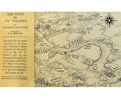
Lot 876
GRAHAME (K.) The Wind in the Willows. First Illustrated Edition. illus. throughout (some full-page, by Ernest H. Shepard), map on e/ps., half title, Methuen's 8pp. general literature list at end; publisher's gilt-pictorial cloth, gilt-lettered on spine, in pictorial d/wrapper. 1931. Illustrated
Lot 895
IRVING OF BONSHAW (J.B.) The Irvings, Irwins, Irvines, or Erinveines . . . an old Scottish border clan. portrait frontis., 10 coloured armorial plates & 81 photo plates (all tissue-guarded), folded map, 5 folded tables (& others in text), publisher's quarter leather & cloth, armorial on upper cover, (spine distressed), thick roy. 4to. Aberdeen: printed and published for the author . . . 1907. * pictorial bookplate of W.I. Armstrong & author's inscription - 'Yrs. Sincerely, / Bonshaw / 8th Nov 1907'.
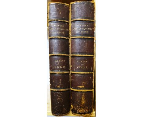
Lot 916
MORANT (Rev. P.) The History and Antiquities of the County of Essex . . . First Edition, 2 vols. engraved & folded county map, 8 folded maps of the hundreds, a folded plan & 22 other copper plates; 19th cent. half morocco & cloth, folio. 1768. * the principal antiquarian history; includes (as published) the revised Colchester text - with the North Prospect view & the detailed plan of the Borough; an EXTRA ILLUSTRATED set, with some 150 additional prints & maps inserted direct or mounted to size - including Buck's large views (ca. 1736), Weale's full- page engravings - some lithographed & coloured (1840s), Hooper's 18th cent. 'antiquarian' copper plates with letterpress, & Dawson's boundary maps (1840s); a handlist of items in these categories available on request

Lot 917
WRIGHT (T.) The History and Topography of the County of Essex . . . First Edition, 2 vols. engraved pictorial & printed titles, county map & 98 steel engraved plates; contemp. calf, gilt & blind-decorated panelled spines, marbled e/ps. & edges, 4to. 1836. * includes some interesting street & quayside views, & an 8pp. subscriber's list.
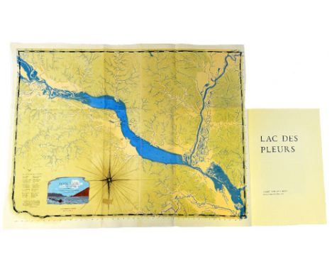
Lot 953
SCHANILEC (G.), editor. Lac des Pleurs: report from Lake Pepin. Limited Edition. 2 full-page coloured illus., 6 coloured illus. on folded leaves, a large-scale coloured & folded map (note on which loosely inserted), text decorations; gilt-lettered leather-backed marbled boards, folio., contained in its leather-backed burgundy cloth box, with paper label & onlaid coloured illus. Stockholm (Wisconsin): Midnight Paper Sales, 2015. * limitation of 100 numbered copies ( with a further 20 sets of unbound sheets), signed by the editor. Illustrated
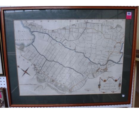
Lot 955
JAMES CLARKE. A Map of the Roads &c. between Keswick, and Broadwater; with James CLARKE - A Map of the Roads, Lakes &c. between Keswick and Ambleside. 58 x 82 & 46 x 78 cms. within mounts, hand coloured, very large- scale, decorative titles. * very detailed - with named houses (& some owners), turnpike gates (etc.), individual fields delineated; being plates 7 & 9 from Clarke's 'A Survey of the Lakes of Cumberland, Westmorland, and Lancashire' (1787) (2)


![GILPIN (W.) [Collected Works on Scenery]. 5 works - being 8 vols. (bound in 4). d-page hand-coloured map, 8 hand-coloured](https://cdn.globalauctionplatform.com/eea48093-787b-476f-879e-a50200d69f2c/9a9ca25c-22a6-47ff-dc0c-7ae948d524fa/468x382.jpg)
Lot 848
GILPIN (W.) [Collected Works on Scenery]. 5 works - being 8 vols. (bound in 4). d-page hand-coloured map, 8 hand-coloured plans, a table & 117 plates (mostly tinted, 2 hand-coloured); near contemp. uniform mottled calf, gilt-decorated spines, 1791-92. * comprises: Remarks on Forest Scenery . . . First Edition, 2 vols. (in one), 1791; Observations, Relative Chiefly to Picturesque Beauty . . . Particularly the High-Lands of Scotland. 2nd edition, 2 vols. (in one), 1792; Observations . . . Particularly the Mountains, and Lakes of Cumberland, and Westmoreland. 3rd edition, 2 vols. (in one), 1792; Three Essays (On Picturesque Beauty. Picturesque Travel: Sketching Landscape . . . ). First Edition, 1792; and bound with: Observations on the River Wye, and Several Parts of South Wales . . . 3rd edition, 1792 * old booklabels of Lady Catherine Bligh & Maj. Gen. Sir Charles Stewart.

Lot 856
VANCOUVER (G.) En Upptackts-Resa till Norra Stilla hafvet, och Kring Jordklotet . . . under Commando Captain George Vancouver. Ifran Engelikan i sammandrag utgifven af Anders Sparmann . . . 2 vols. (bound together). 8 plates & folded map; sometime rebound half calf & boards, red label, sm. 8vo. Stockholm, 1800-01.

Lot 858
DELESSERT (E.) Voyages dans les Deux Oceans: Atlantique et Pacifique, 1844 & 1847. 16 wood-engraved plates, folded plan & map, num. text illus., half title; old green morocco-backed cloth, gilt-decorated spine, patterned e/ps. Paris, 1848. * includes Brazil, United States, Cape of Good Hope, New Zealand, Philippines, China, East Indies (etc.).
![[JOSEPHUS] The Works of Flavius Josephus . . . translated from the original Greek . . . by John Court. copper-engraved](https://cdn.globalauctionplatform.com/eea48093-787b-476f-879e-a50200d69f2c/3e478e6b-2cb9-4c3e-b551-ce4a1a9b3589/468x382.jpg)


Lot 3004
Published British Museum, 1967 AD. Rapson, Edward James, Catalogue of the Coins of the Andhra Dynasty, The Western Ksatrapas, The Traikutaka Dynasty and The Bodhi Dynasty, British Museum, London, 1967 [Reprint edition, ccviii (text) and 268pp. (cataloguing 1,000 coins); folding map and 21 plates]; hardback, with dustwrapper. 975 grams, 22 x 15cm (8 3/4 x 6"). Remains a standard work on the subject, one of the series of catalogues of Indian coins in the British Museum collections, originally published 1908. [No Reserve] Fine condition; dustwrapper sunned and chipped, ownership stamp to f.e.p. and half title.

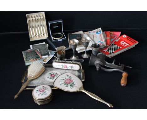
Lot 21
MISC - a collection of household items to include a Kenrick No.10 mincer, a dressing table set to include tray, mirror, brushes and box, ordinance survey maps to include Midlands, North Wales, Snowdon, The Lake District, Leeds and Bradford (1951 - second edition) and Dartmoor, the Bartholomew GT Map Series for South East Scotland, AA through routes to and from Liverpool, National road maps through central and southern Scotland, an LMS Map Sheet 4, a copy of a British Railway England map, a copy of the Elizabeth II Coronation approved souvenir programme, a Shell Historical Map of England & Wales, postcards, a set of x6 EPNS fish knives, a holy bible and a bangle decorated with footprints.

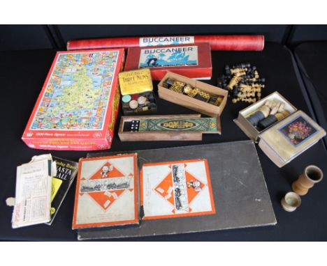
Lot 384
VINTAGE TOYS - a collection of vintage toys to include Buccaneer in original box and board in tube, a traditional Irish monopoly board and accessories - complete, a complete set of wooden chess pieces, an Historical Map of England & Wales 1500 piece jigsaw (unchecked), a pocket bridge device in original packet, chad valley domino pieces in a hand painted wooden dominos case, a set of two tone wooden dominoes, a wooden dice shaker, x16 draught pieces, a J & F Bell "Three Nuns" tin with a variety of loose game pieces, and a copy of The Sunday Times 'Canasta for All' by Colin Harding.


![[TOPOGRAPHY]. SOMERSET Greswell, Rev. William H.P. The Forests & Deer Parks of the County of Somerset, limited edition 149/35](https://cdn.globalauctionplatform.com/e83fd55a-067a-4c0f-b39b-a4f000990bfe/1ecc1c3b-8211-41fd-c155-24fa3d66e8bc/468x382.jpg)
Lot 990
[TOPOGRAPHY]. SOMERSET Greswell, Rev. William H.P. The Forests & Deer Parks of the County of Somerset, limited edition 149/350, Barnicott & Pearce, Taunton, 1905, grey-green cloth, two maps, octavo (spine browned; spine ends and joints partially frayed; upper board with top edge pinch mark); and MacDermot, Edward T. The History of the Forest of Exmoor, Barnicott & Pearce, Taunton, 1911, sage green buckram, map frontispiece, a further nine maps and plate illustrations (as called for), large octavo, INSCRIBED BY AUTHOR, (2).
![[TOPOGRAPHY]. CORNWALL Page, John Lloyd Warden. The North Coast of Cornwall, its Scenery, its People, its Antiquities and its](https://cdn.globalauctionplatform.com/e83fd55a-067a-4c0f-b39b-a4f000990bfe/e46b4a7d-f248-4f47-dd06-bd9c270f2027/468x382.jpg)
Lot 991
[TOPOGRAPHY]. CORNWALL Page, John Lloyd Warden. The North Coast of Cornwall, its Scenery, its People, its Antiquities and its Legends, Crofton / Simpkin et al., Bristol / London, 1897, large paper copy, limited edition 57/75, two-tone cream and green cloth, twenty-one plate illustrations, folding map, quarto.
![[TOPOGRAPHY]. DEVON Polwhele, Rev. Richard. The History of Devonshire, three volumes in one, for Cadell, Johnson & Dilly, Lon](https://cdn.globalauctionplatform.com/e83fd55a-067a-4c0f-b39b-a4f000990bfe/c99fcce5-a8bc-47be-baa1-af2e747217f2/468x382.jpg)
![[TOPOGRAPHY]. DEVON Lysons, Rev. Daniel & Samuel. A Concise Topographical Account or History of the County of Devon, two volu](https://cdn.globalauctionplatform.com/e83fd55a-067a-4c0f-b39b-a4f000990bfe/75c78aff-cf1d-4820-d082-a5c0badc5b2a/468x382.jpg)
![[TRAVEL] The Cruise of Her Majesty's Ship 'Bacchante' 1879-1882, compiled from the Private Journals, Letters, and Note-Books](https://cdn.globalauctionplatform.com/e83fd55a-067a-4c0f-b39b-a4f000990bfe/34336866-a9df-4ef1-c58a-3c962e12e7c5/468x382.jpg)
Lot 994
[TRAVEL] The Cruise of Her Majesty's Ship 'Bacchante' 1879-1882, compiled from the Private Journals, Letters, and Note-Books of Prince Albert Victor and Prince George of Wales, Vols 1 (The West and the South) and 2 (The East), Macmillan, London, 1886, blue cloth gilt with pictorial motif to upper covers, top edges gilt, folding map frontispiece, illustrations, quarto (vol. 2 with wear at spine head and damp marked lower cover).
![[MAPS]. CHRISTOPHER SAXTON (C.1540-C.1610) & WILLIAM KIP 'Warwici comitatus a cornauiis olim inhabitatus' [Warwickshire],
en](https://cdn.globalauctionplatform.com/e83fd55a-067a-4c0f-b39b-a4f000990bfe/a8617e2b-ad0e-43e4-b22d-f6717685a645/468x382.jpg)
![[MAPS]. CHRISTOPHER SAXTON (C.1540-C.1610) 'Oxonii Buckinghamiae et Berceriae Comitatum' [The Counties of Oxfordshire, Buckin](https://cdn.globalauctionplatform.com/e83fd55a-067a-4c0f-b39b-a4f000990bfe/cd2a7e4c-5ec2-479a-c8b8-e1ed0fb9d8df/468x382.jpg)


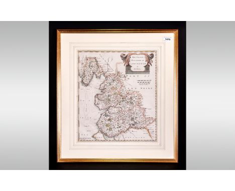
Lot 164
A bamboo sword stick, 93cm long, together with a walking stick, riding crop and framed map of Great Britain (4) CONDITION REPORT: Lot 164 - Riding crop is in fair condition, walking stick in fair condition, sword stick - scabbard is burnt and charred, collar lacking, sword top lacking, handle cracked (along grain), well worn, map faded and creased in areas.


Lot 40
John Ogilby Rare Hand Coloured Period Map Showing The Kingdon Of England & Wales With Royal Cartouches And Royal Crests, and a catalogue of major roads delineated, a new map revised, with full margins, in good original state. By John Ogilby his Majesties Cosmographer. Late 17th Century framed, glazed & mounted.
Lot 41
Robert Mordem County Map Of The Palatine Of Lancashire, period hand coloured print, framed, mounted & glazed showing Lancashire and its coastline and parts of Cheshire. Sold by Abel Swaleawnsham and John Churchill Late 17th Century. 23x25'' with full margins, from Mordens Famous Folio Of English County Maps Of The Period.

Lot 42
Rare Coastal Chart Map Of Lancashire, Showing The Isle Of Mann And Angelsey, with Vingenettes showing a little & great Ormes and the Chester Ban. Hand coloured wash of the period, cartouche dedicated to the most honourable Si John Lowther Bart, One of the commissioners for executing the office of Lord High Admiral Of England. Full margins. Late 17th Century framed, glazed & mounted. 29x25''


Lot 49
Christopher Saxon Map 'Lancashire Brigantum' Hand Coloured & Period From His Famous Book 'The County Maps Of England Depicting The County Of Lancashire & Its Coastline with parts of the West Morland and Cumberland 'Guliel Hole Sculptor with full margins and period hand wash. Late 17th Century, framed, glazed & mounted. 18x18''
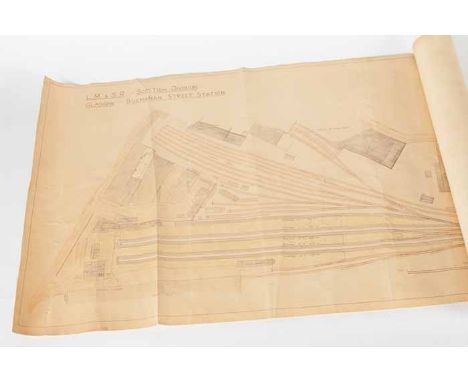
Lot 145
EARLY 20TH CENTURY RAILWAY STATION LAYOUT MAP OF BUCHANAN STREET STATION London, Midland & Scottish Railways Scottish Division track and platform full layout of Buchanan Street, Glasgow, scale of one inch to thirty three feet, printed onto thin fabric, rolled up in a cardboard sleeve, 56cm high x 167cm long

Lot 207
Henry W Taunt - A New Map of the River Thames, form Oxford to London, from entirely new surveys taken during the summer of 1871 - 2nd edition, April 1873 - book states 80 photographs but only 79 present CONDITION REPORT: appears complete, slight staining, green cloth binding slightly scuffed
-
109182 item(s)/page